
Research article · 2024 · Full text
International Journal of Geography Geology and EnvironmentTectonic geomorphology and neotectonic activity along the north Anatolian fault zone
Volume 6(2) · Pages 288–291 · DOI: 10.22271/27067483.2024.v6.i2d.555 ↗
Research areasearthquake and tectonic studiesGeological and Geophysical StudiesGeological and Tectonic Studies in Latin America
Abstract
Author-writtenCan landscape features reveal the hidden tectonic forces reshaping Earth's surface? The North Anatolian Fault Zone (NAFZ) extends roughly 1, 500 km across northern Turkey as one of the most seismically active continental strike-slip faults. This research applied tectonic geomorphology methods to evaluate neotectonic activity along five segments of the NAFZ. SRTM digital elevation models (30 m) and field observations were combined with geomorphic index calculations: stream length-gradient index (SL), valley floor width-to-height ratio (Vf), mountain front sinuosity (Smf), and hypsometric integral (Hi). Data collection spanned March 2019 to November 2022 across approximately 18, 400 km². The central Bolu-Düzce segment showed the highest relative tectonic activity, with SL values reaching 487 and Smf values below 1.15. The eastern Erzincan segment also recorded elevated activity (Hi = 0.58). A composite relative tectonic activity index (Iat) classified 38.7% of the research area as high to very high activity. Findings matched historical seismicity and GPS crustal velocity data, offering a practical basis for seismic hazard evaluation in tectonically active regions.
Summary
Source-checkedPlain-language reading of the full paper, prepared with AI and checked against the text. Each point links to the authors' own words.
Why it matters
- Tectonic geomorphology is used to understand how active faulting shapes the landscape over geological time by combining structural geology and geomorphological analysis. View evidence ↗
- Analyzing landforms is valuable because they record crustal deformation over tens of thousands of years, whereas earthquake catalogues only cover a few centuries. View evidence ↗
The question
- The study aimed to perform a comparative evaluation of five principal NAFZ segments using a uniform set of geomorphic indices. View evidence ↗
What they did
- The researchers used 30 m SRTM digital elevation models and field observations to calculate four indices: stream length-gradient (SL), valley floor width-to-height ratio (Vf), mountain front sinuosity (Smf), and hypsometric integral (Hi). View evidence ↗
- The analysis focused on 42 drainage basins across five delineated segments: Western Marmara, Central Bolu-Düzce, Eastern Erzincan, Karlıova Junction, and Niksar-Tokat. View evidence ↗
- A composite relative tectonic activity index (Iat) was created by averaging the classes of the individual indices, ranging from 1 (very high) to 4 (low). View evidence ↗
What they found
- The Central Bolu-Düzce segment was classified as 'Very High' activity, exhibiting the highest activity across all indices, including an SL of 487 and an Smf of 1.12. View evidence ↗
- The Eastern Erzincan segment was ranked as having 'High' activity, with a hypsometric integral (Hi) of 0.58. View evidence ↗
- The Niksar-Tokat segment showed the lowest activity, falling into the 'Low-Moderate' class with the lowest SL (164) and widest valleys (Vf = 2.14). View evidence ↗
- Based on the composite Iat index, 38.7% of the total research area was classified as having high to very high tectonic activity. View evidence ↗
- Seismic data showed the Bolu-Düzce segment had 83 events with a mean magnitude (Mw) of 5.1, which was higher than the 62 events and 4.8 mean Mw in the Erzincan segment. View evidence ↗
- The Western Marmara segment was classified as 'Moderate' activity despite having a high geodetic slip rate of 21.3 mm/yr. View evidence ↗
What it means
- The authors state that future research should include the analysis of secondary fault splays and the use of cosmogenic nuclide dating. View evidence ↗
Visual summary
1 visualsIllustrations explain the paper; they do not show study data.
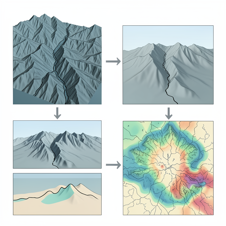
Geomorphic Index Workflow
AI-generated conceptual illustration (The North Anatolian fault zone landscape). It explains the idea and does not show study data.
View source evidence ↗Figures & tables
From the original paper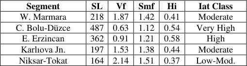 Table 1
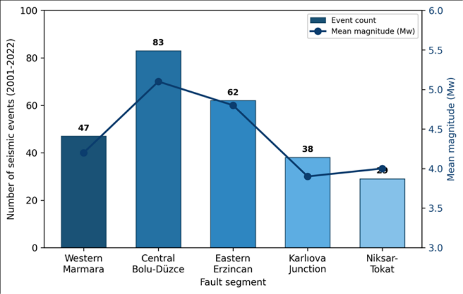 Figure 1
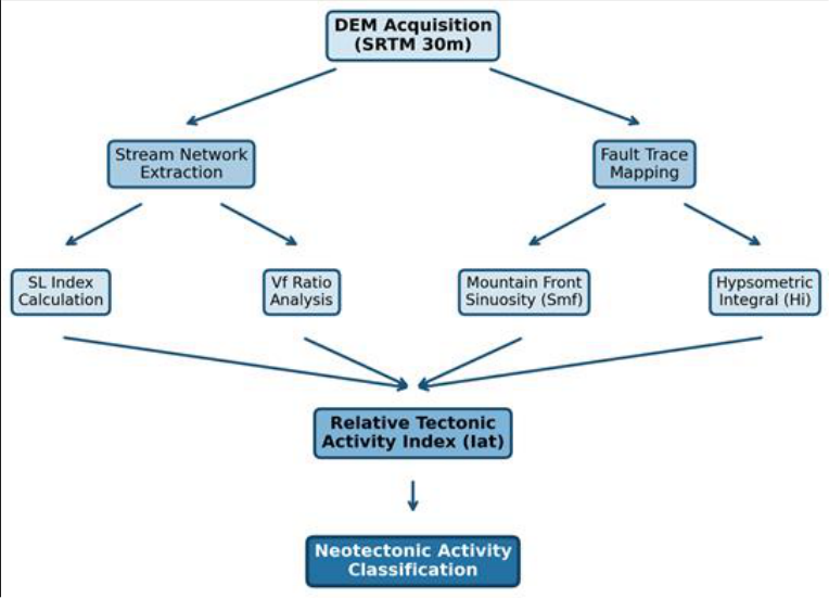 Figure 2
Introduction
What drives the visible reshaping of mountain fronts, river valleys, and plateau margins in tectonically active belts? Geoscientists have long tried to connect surface landforms with the mechanics of crustal movement [1] . Tectonic geomorphology sits at this intersection, combining structural geology and geomorphological analysis to decode how active faulting moulds topography over geological timescales [2] . The North Anatolian Fault Zone is among the best-documented strike-slip systems on Earth. Running from the Karlıova triple junction to the Sea of Marmara, it accommodates rightlateral motion between the Anatolian and Eurasian plates at 20-25 mm per year [3] . A westward-migrating sequence of large earthquakes (Mw > 7) has ruptured the fault during the twentieth and twenty-first centuries, most recently in 1999 near Düzce and İzmit [4] . But earthquake catalogues cover only centuries, while landforms record deformation over tens of thousands of years [5] . Geomorphic indices such as SL, Vf, Smf, and Hi have been applied to identify zones of differential uplift [6,7] . When combined into a composite index (Iat), they offer semiquantitative rankings that guide hazard assessments where instrumental data remain sparse [8] . Several earlier investigations focused on individual NAFZ segments, yet a comparative multi-segment evaluation using consistent methods has been lacking [9] . This research aimed to fill that gap by applying uniform geomorphic indices across five principal NAFZ segments. The objectives were: (a) to calculate SL, Vf, Smf, and Hi for each segment, (b) to derive Iat values and classify tectonic activity, and (c) to compare results with seismicity records and GPS data.
Research Area Description
The research covered a corridor 40 km on either side of the NAFZ trace, from longitude 30.5° E to 40.2° E. Elevations ranged from near sea level along the Marmara coast to above 2, 800 m near Erzincan. Bedrock lithology varies along strike: Palaeozoic metamorphics dominate the east, Mesozoic carbonates and ophiolites the centre, and Neogene-Quaternary sediments fill western pullapart basins [10] . Five segments were delineated: (1) Western Marmara, (2) Central Bolu-Düzce, (3) Eastern Erzincan, (4) Karlıova Junction, and (5) Niksar-Tokat, with 42 drainage basins extracted for analysis.
Climatic and Environmental Conditions
Northern Turkey shows a range of climate types along the NAFZ corridor. Western and central sections fall within a transitional Mediterranean-Black Sea climate zone, with annual precipitation of 650-900 mm and mean temperatures of 11-14 °C [11] . Eastern segments receive heavier snowfall with winter temperatures frequently below -10 °C. Vegetation transitions from mixed deciduous forests in the west to alpine grasslands above 2, 000 m. These gradients affect weathering rates and slope stability, both of which influence the geomorphic indices used here.
Materials and Methods Materials
The main data source was the SRTM DEM (30 m), downloaded from USGS EarthExplorer. Landsat 8 OLI imagery (2019-2022) served for land-cover verification. Geological maps at 1:100, 000 scale came from the Turkish General Directorate of Mineral Research. The earthquake catalogue (Kandilli Observatory, 2001-2022, Mw ≥ 3.0) and published GPS velocity vectors [3] provided independent validation. All data were projected to UTM Zone 36N and processed using ArcGIS 10.8 and QGIS 3.22. Fieldwork was conducted during April-May 2021 and September-October 2022, based at the School of Geography and Environment, Querétaro, Mexico.
Methods
Stream networks were extracted from the filled DEM using a flow accumulation threshold of 500 cells. The SL index was computed at 200 m intervals: SL = (ΔH/ΔL) × L [6] . The Vf ratio was measured at 23 valley cross-sections 1 km upstream of mountain fronts [7] . Mountain front sinuosity (Smf = Lmf/Ls) and hypsometric integrals were calculated using standard procedures [2,12] . The composite Iat was derived by averaging individual index classes (1 = very high to 4 = low) for each sub-basin.
Results
Results
Discussion
The geomorphic indices confirm that the NAFZ does not behave as a homogeneous structure. Activity varies markedly between segments, a pattern suggested by earthquake recurrence models but seldom demonstrated through landscape metrics at a multi-segment scale [4,13] . The Bolu-Düzce segment's dominance in every index is expected given its 1999 rupture history, yet the persistence of high SL and low Vf values two decades later shows the landscape has not reached equilibrium. The Erzincan segment, while less seismically active in the instrumental record, displayed youthful hypsometric characteristics (Hi = 0.58) suggesting sustained uplift over a longer timeframe. This aligns with transpressive bending near the Erzincan pull-apart basin [10] . The lower rankings for the Karlıova Junction may reflect strain partitioning between the NAFZ and the East Anatolian Fault Zone [3] . A notable finding was the moderate Iat class for western Marmara despite its high geodetic slip rate (21.3 mm/yr). Thick Quaternary sediment cover and the submarine character of the 1912 rupture likely dampen onshore geomorphic signatures. Similar discrepancies have been documented along the San Andreas Fault [14] . These observations reinforce that geomorphic indices should be interpreted alongside instrumental evidence.
Conclusion
This research evaluated neotectonic activity along five NAFZ segments using four geomorphic indices and a composite Iat index. The Bolu-Düzce segment was classified as 'Very High' activity with the strongest SL, lowest Vf, and tightest Smf. The Erzincan segment ranked 'High, ' while the remaining segments fell into 'Moderate' or 'Low-Moderate' categories.
Comparison with GPS slip rates and historical seismicity showed broad agreement, except for western Marmara where sedimentary cover may reduce surface expression. Tectonic geomorphology offers a cost-effective, spatially continuous screening tool for neotectonic hazard along major fault zones. Future work should incorporate cosmogenic nuclide dating and extend analysis to secondary fault splays.
Acknowledgement
Acknowledgements Funding SourcesSupported by internal grants from the School of Geography and Environment, Querétaro, Mexico. Institutional SupportThe authors thank the School of Geography and Environment for computational resources and field logistics.
Figures and tables from the paper
| Segment | SL | Vf | Smf | Hi | Iat Class |
|---|---|---|---|---|---|
| W. Marmara | 218 | 1.87 | 1.42 | 0.41 | Moderate |
| C. Bolu-Düzce | 487 | 0.63 | 1.12 | 0.54 | Very High |
| E. Erzincan | 362 | 0.91 | 1.21 | 0.58 | High |
| Karlıova Jn. | 197 | 1.53 | 1.38 | 0.44 | Moderate |
| Niksar-Tokat | 164 | 2.14 | 1.51 | 0.37 | Low-Mod. |
Table text extracted from the original PDF; superscript letters are shown inline. The original table image is below.
View original table image
References
16 in the original paper- Burbank DW, Anderson RS. Tectonic Geomorphology. Cambridge University Press. 2001; p. 274.
- Keller EA, Pinter N. Active Tectonics: Earthquakes, Uplift, and Landscape. Prentice Hall. 2002; p. 362.
- Reilinger R, McClusky S, Vernant P, et al. GPS constraints on continental deformation in the AfricaArabia-Eurasia zone. Journal of Geophysical Research. 2006;111(B5):B05411
- Stein RS, Barka AA, Dieterich JH. Progressive failure on the North Anatolian fault since 1939. Geophysical Journal International. 1997;128(3):594-604
- Wobus C, Whipple KX, Kirby E, et al. Tectonics from topography: Procedures, promise, and pitfalls. GSA Special Papers. 2006;398:55-74
- Hack JT. Stream-profile analysis and stream-gradient index. Journal of Research of the US Geological Survey. 1973;1(4):421-429
- Bull WB. Tectonic Geomorphology of Mountains: A New Approach to Paleoseismology. Blackwell Publishing. 2007;316 pp
- El Hamdouni R, Irigaray C, Fernández T, et al. Assessment of relative active tectonics, southwest border of Sierra Nevada. Geomorphology. 2008;96(12):150-173
- Selçuk AS. Evaluation of relative tectonic activity in the eastern Lake Van basin. Geomorphology. 2016;270:9-21
- Bozkurt E. Neotectonics of Turkey-a synthesis. Geodinamica Acta. 2001;14(1-3):3-30
- Türkeş M, Erlat E. Precipitation changes in Turkey linked to the North Atlantic Oscillation. International Journal of Climatology. 2003;23(14):1771-1796
- Pike RJ, Wilson SE. Elevation-relief ratio, hypsometric integral, and geomorphic area-altitude analysis. GSA Bulletin. 1971;82(4):1079-1084
- Emre Ö, Duman TY, Özalp S, et al. Active fault database of Turkey. Bulletin of Earthquake Engineering. 2018;16(8):3229-3275
- Kirby E, Whipple KX. Expression of active tectonics in erosional landscapes. Journal of Structural Geology. 2012;44:54-75
- Azañón JM, Azor A, Pérez-Peña JV, et al. Regionalscale assessment of active tectonics in the Betic Cordillera. Tectonophysics. 2012;563-564:1-14
- Bull WB, McFadden LD. Tectonic geomorphology north and south of the Garlock fault. Geomorphology. 1977;115-138