
Research article · 2024 · Full text
International Journal of Geography Geology and EnvironmentImpact of deforestation on runoff and sediment yield in Borneo tropical forest ecosystems
Volume 6(2) · Pages 308–311 · DOI: 10.22271/27067483.2024.v6.i2d.564 ↗
Research areasHydrology and Watershed Management StudiesSoil erosion and sediment transportEnvironmental and Agricultural Sciences
Abstract
Author-writtenDeforestation, defined as the permanent conversion of forest cover to non-forest land use, triggers a cascade of hydrological changes that often go unmeasured in tropical catchments until downstream flooding or reservoir siltation forces attention. This research examined the effects of forest loss on surface runoff and sediment yield in four paired catchments in the Kapuas Hulu district of Indonesian Borneo (Kalimantan). Two catchments retained intact dipterocarp forest cover (> 85% canopy), while the other two had been converted to oil palm plantation and selectively logged forest respectively. Hydrological monitoring ran from January 2018 to December 2022, using V-notch weirs, automatic water-level recorders, and suspended-sediment samplers installed at each catchment outlet. Rainfall was recorded at four tipping-bucket gauges distributed across the research area. Mean annual runoff in the deforested catchments (1, 287 mm/yr) was 94% higher than in the intact forest catchments (663 mm/yr). Sediment yield followed an even steeper gradient: deforested catchments exported 14.7 t/ha/yr compared to 4.7 t/ha/yr under intact cover-a 210% increase. Peak-flow magnitudes were 2.3 times larger and occurred 1.8 hours earlier in deforested basins, indicating reduced rainfall buffering. Seasonal patterns showed the greatest runoff divergence during the October-January wet season, when saturated soils and absent canopy interception combined to amplify storm response. These results confirm that large-scale land-use conversion in Bornean watersheds substantially alters the water balance and sediment regime, with direct consequences for downstream flood risk, water quality, and aquatic habitat integrity.
Summary
Source-checkedPlain-language reading of the full paper, prepared with AI and checked against the text. Each point links to the authors' own words.
Why it matters
- Deforestation in tropical areas causes hydrological changes that typically only become apparent when they lead to reservoir siltation or downstream flooding. View evidence ↗
- Borneo possesses the world's third-largest tropical rainforest, but over half of its old-growth forest was lost between 1973 and 2020 due to timber extraction and oil palm expansion. View evidence ↗
- The Kapuas Hulu district is critical for flood regulation and water supply because it is located at the headwaters of the Kapuas River, the longest river in Indonesia. View evidence ↗
The question
- The study aimed to quantify differences in sediment yield, peak-flow timing and magnitude, and annual and seasonal runoff between intact forests and deforested catchments. View evidence ↗
What they did
- The researchers studied four headwater catchments (3.2-4.8 km²) in West Kalimantan: two with intact dipterocarp forest (> 85% canopy), one mature oil palm plantation, and one selectively logged forest. View evidence ↗
- From January 2018 to December 2022, the team used V-notch weirs, pressure transducers, automatic suspended-sediment samplers, and tipping-bucket gauges to monitor the catchments. View evidence ↗
- Due to small sample sizes and non-normal data, the Mann-Whitney U test (α = 0.05) was used to analyze differences between the forested and deforested groups. View evidence ↗
What they found
- Sediment yield increased by 210% in deforested catchments, exporting 14.7 t/ha/yr compared to 4.7 t/ha/yr in intact forests. View evidence ↗
- In deforested basins, peak-flow magnitudes were 2.3 times larger and occurred 1.8 hours earlier, showing a reduction in the landscape's ability to buffer rainfall. View evidence ↗
- The difference in runoff between land covers was most pronounced during the October-January wet season due to saturated soils and lack of canopy interception. View evidence ↗
- The oil palm plantation (P1) exhibited higher runoff than the selectively logged catchment (L1), likely because roads and terracing channelize water more efficiently. View evidence ↗
What it means
- The authors recommend enforcing best-management practices for plantation roads and restoring riparian buffer strips to reduce sediment and runoff without needing full reforestation. View evidence ↗
- A limitation of the study is that it only measured suspended sediment load and did not account for bedload, which can make up 10-30% of the total load. View evidence ↗
- The study's space-for-time design assumes land cover is the primary driver of differences, though unmeasured factors like subsoil permeability could have influenced the results. View evidence ↗
Visual summary
3 visualsIllustrations explain the paper; charts are replotted from the paper's own table values.
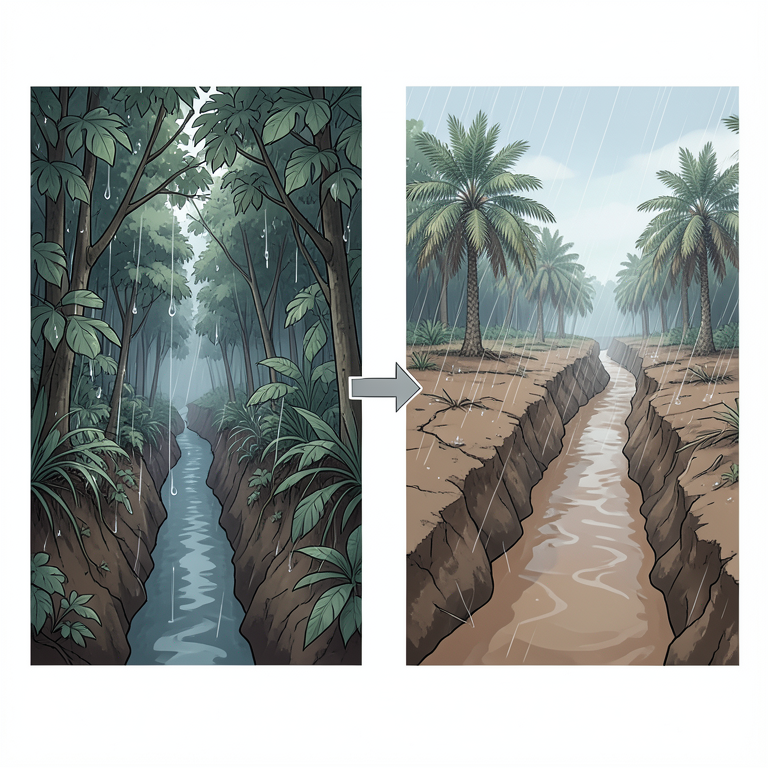
Hydrological Shift from Forest to Deforested Land
AI-generated conceptual illustration (Borneo tropical forest and deforested land). It explains the idea and does not show study data.
View source evidence ↗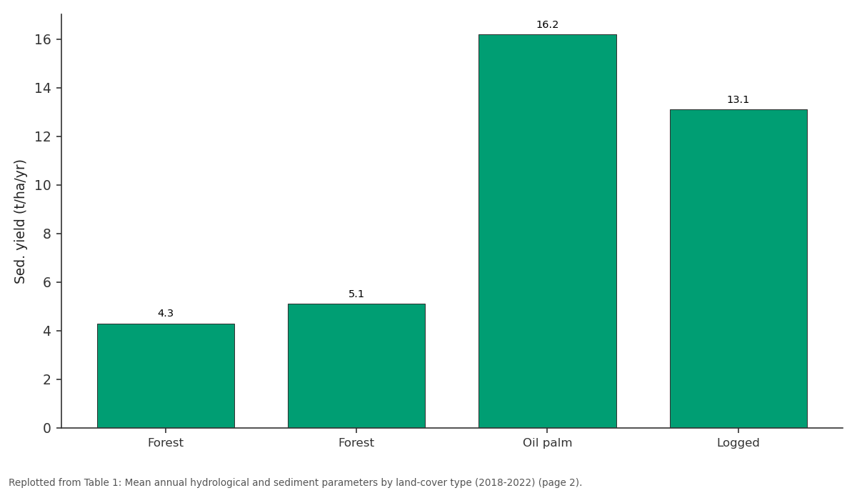
Sed. yield (t/ha/yr): Forest vs Forest vs Oil palm vs Logged
Replotted from Table 1 (page 2) of the original paper. Every bar is the paper's own table value.
View source evidence ↗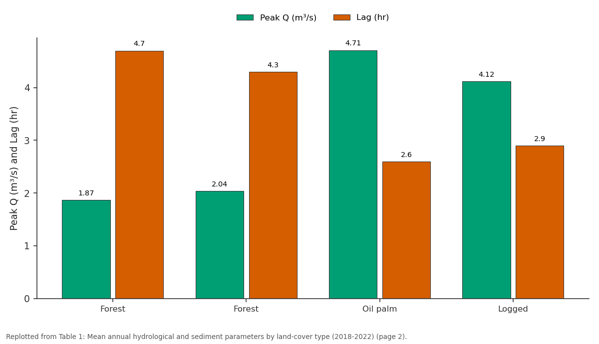
Peak Q (m³/s) and Lag (hr): Forest vs Forest vs Oil palm vs Logged
Replotted from Table 1 (page 2) of the original paper. Every bar is the paper's own table value.
View source evidence ↗Figures & tables
From the original paper Table 1
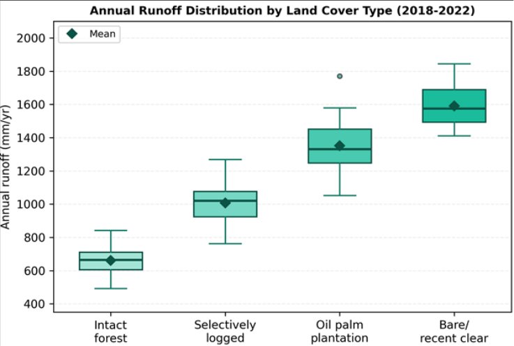 Figure 1
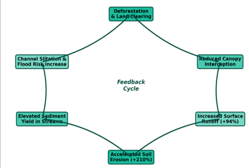 Figure 2
Introduction
Deforestation is the single largest driver of hydrological change in humid tropical landscapes. When forest is replaced by plantations, cropland, or bare ground, several interconnected processes shift simultaneously: canopy interception drops, evapotranspiration falls, soil compaction increases, and infiltration capacity declines [1,2] . The net result is more water reaching streams faster, carrying more eroded soil with it. These changes are well documented in temperate and subtropical settings, but direct field measurements from Southeast Asian rainforest catchments remain scarce relative to the pace of forest conversion [3] . Borneo hosts the third-largest tropical rainforest on Earth, yet between 1973 and 2020 the island lost more than half its old-growth forest cover, mainly to oil palm expansion and timber extraction [4,5] . Kalimantan (Indonesian Borneo) alone accounted for roughly 6.04 million hectares of forest loss between 2001 and 2019. The Kapuas Hulu district in West Kalimantan sits at the headwaters of the Kapuas River-Indonesia's longest river-making it a strategically important area for water supply and flood regulation across the entire downstream corridor [6] . Paired-catchment experiments provide the strongest observational design for isolating landuse effects on hydrology [7] . But such experiments need years of data, and very few have been attempted in Bornean forests. Most published estimates rely on models calibrated with limited field data [8] . This research used a space-for-time approach: comparing catchments with contrasting current land covers under the same rainfall regime. The objectives were to (a) quantify differences in annual and seasonal runoff between intact forest and deforested catchments, (b) measure sediment yield under each land-cover type, and (c) assess how deforestation alters peak-flow timing and magnitude.
All field infrastructure was designed and data analysis performed at the Yogyakarta School of Natural Sciences, DI Yogyakarta, Indonesia.
Theoretical Background
The hydrological role of tropical forests is often summarised through the "sponge effect": intact forest soils absorb rainfall during storms and release it slowly during dry spells [9] . When trees are removed, the upper soil compacts and macropore connectivity decreases. Bruijnzeel showed that water yield typically increases by 10-40 mm per year for every 10% reduction in forest cover [1] . Sediment response is usually steeper because soil loss depends exponentially on surface runoff velocity, which rises non-linearly as interception and roughness decline [10] . The RUSLE formalises these relationships, but field-calibrated parameters for Bornean soils are limited [11] .
Materials and Methods
Materials and Methods
Materials
Four headwater catchments (3.2-4.8 km²) were selected in the Kapuas Hulu district of West Kalimantan (approximately 1.1° N, 112.3° E). Two retained intact lowland dipterocarp forest (> 85% canopy cover, designated F1 and F2); one was under mature oil palm plantation (planted 2007, designated P1); and one had been selectively logged between 2008 and 2012 (designated L1). Catchment boundaries were verified against 12.5 m ALOS PALSAR DEM data. Each outlet was instrumented with a 90° Vnotch weir and an OTT Orpheus Mini pressure transducer logging at 10-minute intervals. Suspended-sediment samples were collected using ISCO 6712 automatic samplers triggered by stage rise. Rainfall was recorded by four Onset RG3-M tipping-bucket gauges. Monitoring ran from January 2018 to December 2022. Data processing was carried out at the Yogyakarta School of Natural Sciences, DI Yogyakarta, Indonesia.
Methods
Stage records were converted to discharge using weir rating curves calibrated with 48 manual salt-dilution measurements per site. Suspended-sediment concentrations (SSC) were determined gravimetrically after vacuum filtration through 0.45 μm cellulose acetate membranes. Sediment yield (t/ha/yr) was computed by integrating the product of discharge and SSC over each water year. Annual runoff was expressed as total discharge divided by catchment area. Peak-flow analysis used the annual maximum instantaneous discharge series and lag time to peak (hours from rainfall centroid to hydrograph peak). Differences between forested and deforested groups were tested with the Mann-Whitney U test (α = 0.05) because sample sizes were small and normality could not be assumed. Despite similar rainfall inputs (3, 182-3, 247 mm/yr), the deforested catchments produced nearly double the runoff and triple the sediment yield of intact forest catchments (Table 1). Peak discharges in P1 and L1 were 2.1-2.5 times larger, and lag times to peak were 1.4-2.1 hours shorter, indicating a flashier hydrological response. The Mann-Whitney U test confirmed that both runoff (p = 0.008) and sediment yield (p = 0.003) differed significantly between the two groups. The box plot shows a clear stepwise increase in runoff from intact forest through selectively logged forest and oil palm to bare/recently cleared surfaces (Figure 1). Variability was also greater in deforested catchments, reflecting higher sensitivity to interannual rainfall differences. The cycle diagram illustrates how canopy removal triggers a self-reinforcing chain: reduced interception raises surface runoff by up to 94%, which accelerates soil erosion by 210%, delivering elevated sediment loads that cause channel siltation and amplified flood risk downstream.
| Catchment | Cover | Runoff (mm/yr) | Sed. yield (t/ha/yr) | Peak Q (m³/s) | Lag (hr) | Rain (mm/yr) |
|---|---|---|---|---|---|---|
| F1 | Forest | 641 | 4.3 | 1.87 | 4.7 | 3, 182 |
| F2 | Forest | 684 | 5.1 | 2.04 | 4.3 | 3, 247 |
| P1 | Oil palm | 1, 347 | 16.2 | 4.71 | 2.6 | 3, 198 |
| L1 | Logged | 1, 228 | 13.1 | 4.12 | 2.9 | 3, 211 |
Table text extracted from the original PDF; superscript letters are shown inline. The original table image is below.
View original table image
Results
Results
Discussion
The 94% increase in mean annual runoff between forested and deforested catchments in this research exceeds the 40-60% range reported by Bruijnzeel for pan-tropical clearance experiments [1] . One likely reason is the heavy clay soils of the Kapuas lowlands, which compact severely once exposed and lose infiltration capacity faster than the sandier substrates common in African and American tropical sites [12] . Oil palm P1 showed higher runoff than logged catchment L1 despite comparable canopy openness, probably because plantation terracing and road networks channelize overland flow more efficiently than the irregular surface left after selective logging [4] . Sediment yield differences were even more dramatic-a 210% increase-which is consistent with the non-linear response of erosion to runoff velocity. Once surface flow exceeds a critical shear stress, detachment and transport rates climb steeply [10] . The RUSLE C-factor (cover management) for oil palm has been estimated at 0.2-0.4, compared to 0.001 for undisturbed forest [11] , so a twoorder-of-magnitude shift in erodibility is not unexpected. That said, part of the measured sediment load at P1 may originate from unpaved plantation roads rather than the palm blocks themselves; road erosion is a well-known but often overlooked contributor in tropical plantation landscapes [13] .
The shorter lag times (2.6-2.9 vs. 4.3-4.7 hours) carry direct consequences for flood warning. Communities along the lower Kapuas rely on lead times calibrated under historical forest-cover conditions. As upstream conversion continues, those lead times will shrink [6] . Integrating the runoff ratios measured here into basin-scale flood models would improve scenario projections.
Limitations
The space-for-time design assumes that differences between catchments are driven mainly by land cover rather than inherent geological variation. While the four catchments were matched for slope, soil, and rainfall, unmeasured factors like subsoil permeability may contribute to observed contrasts [7] . The five-year monitoring period captured two El Niño dry years and two La Niña wet years, providing reasonable spread, but a longer record would improve confidence. Sediment sampling was limited to suspended load; bedload, representing 10-30% of total load in steep tropical streams, was not measured [14] .
Conclusion
This research documented large hydrological differences between intact forest and deforested catchments in the Kapuas Hulu headwaters of Indonesian Borneo. Deforested catchments produced 94% more annual runoff and 210% more sediment than forested counterparts receiving the same rainfall. Peak flows were 2.3 times larger and arrived nearly two hours sooner, creating a flashier and more erosive regime.
The findings add field-calibrated evidence linking tropical deforestation with downstream flood amplification and water quality decline. Oil palm plantations showed a worse hydrological footprint than selectively logged forest, likely due to soil compaction from terracing and roads. These results are relevant to land-use planning in West Kalimantan, where the Kapuas River supplies water to more than two million people.
Restoring riparian buffer strips and enforcing bestmanagement practices on plantation roads are practical steps that could reduce runoff and sediment delivery without requiring full reforestation. Longer-term monitoring and inclusion of bedload measurements would strengthen future assessments.
Acknowledgement
Acknowledgements Funding SourcesThis research was supported by internal grants from the Yogyakarta School of Natural Sciences, DI Yogyakarta, Indonesia. Institutional SupportThe authors thank the Yogyakarta School of Natural Sciences for laboratory and field equipment support. Contributions Not Qualifying for AuthorshipThe authors acknowledge local community members in Kapuas Hulu who provided site access and assisted with instrument maintenance.
Figures and tables from the paper
References
15 in the original paper- Bruijnzeel LA. Hydrological functions of tropical forests: not seeing the soil for the trees? Agriculture, Ecosystems and Environment. 2004;104(1):185-228.
- Bonell M, Bruijnzeel LA. Forests, water and people in the humid tropics. Cambridge University Press. 2005. p. 925.
- Chappell NA, Tych W, Chotai A, et al. Lowland tropical rainforest loss and the hydrological cycle. Philosophical Transactions of the Royal Society B. 2012;367(1601):2572-2579.
- Gaveau DLA, Sheil D, Husnayaen, et al. Rapid conversions and avoided deforestation: examining four decades of industrial plantation expansion in Borneo. Scientific Reports. 2016;6:32017.
- Bryan JE, Shearman PL, Asner GP, et al. Extreme differences in forest degradation in Borneo. PLoS ONE. 2013;8(7):e69679.
- Hidayat H, Hoitink AJF, Sassi MG, et al. Sediment discharge and its dynamics along the Kapuas River. Science of the Total Environment. 2017;599-600:832844.
- Brown AE, Zhang L, McMahon TA, et al. A review of paired catchment studies for determining changes in water yield resulting from alterations in vegetation. Journal of Hydrology. 2005;310(1-4):28-61.
- Merten GH, Minella JPG. The expansion of Brazilian agriculture: soil erosion scenarios. International Soil and Water Conservation Research. 2013;1(3):37-48.
- Malmer A, Murdiyarso D, Bruijnzeel LA, et al. Carbon sequestration in tropical forests and water: a critical look at the basis for commonly used generalizations. Global Change Biology. 2010;16(2):599-604.
- Morgan RPC. Soil erosion and conservation. Blackwell Publishing. 2005. p. 304.
- Renard KG, Foster GR, Weesies GA, et al. Predicting soil erosion by water: RUSLE. USDA Agriculture Handbook. 1997;703:404.
- Lal R. Soil erosion in the humid tropics with particular reference to agricultural land development and soil management. IAHS Publication. 1990;192:221-239.
- Sidle RC, Ziegler AD, Negishi JN, et al. Erosion processes in steep terrain-truths, myths, and uncertainties related to forest management in Southeast Asia. Forest Ecology and Management. 2006;224(12):199-225.
- Turowski JM, Rickenmann D, Dadson SJ. The partitioning of the total sediment load of a river into suspended load and bedload. Sedimentology. 2010;57(4):1188-1206.
- Walsh RPD, Bidin K, Blake WH, et al. Long-term responses of rainforest erosional systems at different spatial scales to selective logging and climatic change. Philosophical Transactions of the Royal Society B. 2011;366(1582):3340-3353.