
Research article · 2025 · Full text
International Journal of Geography Geology and EnvironmentImpact of land reclamation on tidal flat morphology in the Bohai bay
Volume 7(3) · Pages 112–115 · DOI: 10.22271/27067483.2025.v7.i3b.523 ↗
Research areasCoastal and Marine DynamicsCoastal wetland ecosystem dynamicsEnvironmental Changes in China
Abstract
Author-writtenBetween 1985 and 2020, land reclamation along the Bohai Bay coastline of northeastern China converted approximately 387 km² of intertidal and subtidal flats into industrial, port, and aquaculture land—one of the largest coastal-transformation programs in history. This research quantified the morphological consequences of that reclamation on adjacent tidal flats using multi-decadal Landsat imagery, nautical chart bathymetry, and tidal-prism calculations. Cumulative reclaimed area grew exponentially from 12.4 km² in 1985 to 387.1 km² by 2020, with the steepest expansion between 2005 and 2015 (mean 18.4 km²/yr). Concurrent changes on remaining tidal flats included a mean surface-elevation decline of 2.1 m, a 41% reduction in tidal prism, a 28% narrowing of tidal channels, and a shift from net accretion (1.2 m/yr in 1985) to near-zero accretion by 2020. A sediment-budget analysis attributed 62% of the elevation loss to reduced sediment supply caused by river damming and 38% to altered hydrodynamics—increased tidal-current velocities through constricted channels that erode rather than deposit. These findings warn that continued reclamation without compensatory sediment management risks irreversible loss of the remaining tidal-flat ecosystem and the fisheries and storm-buffering services it provides.
Summary
Source-checkedPlain-language reading of the full paper, prepared with AI and checked against the text. Each point links to the authors' own words.
Why it matters
- Tidal flats provide critical ecosystem services, including nutrient cycling, fish nursery habitats, and protection against storm surges, but they are highly vulnerable to land reclamation. View evidence ↗
- Bohai Bay was a primary target for land reclamation due to its gentle seabed gradient and shallow bathymetry, with a mean depth of less than 18 m. View evidence ↗
- The loss of tidal flats leads to a series of morphological changes, such as the narrowing of estuary channels and shifts in the balance between erosion and sediment deposition. View evidence ↗
The question
- The study aimed to track land reclamation over 35 years and determine how it affected tidal-flat elevation, channel width, and tidal prism, while distinguishing between the roles of sediment supply and hydrodynamics. View evidence ↗
What they did
- Researchers used Landsat imagery from eight specific time steps between 1985 and 2020 to delineate the waterline at mean tide level. View evidence ↗
- Seabed elevation grids with a 100 m resolution were created by digitizing and interpolating 14 nautical charts from 1983 to 2019. View evidence ↗
- Tidal prism volumes were calculated using a mean spring tidal range of 2.8 m, and channel widths were measured across 12 perpendicular cross-sections. View evidence ↗
- A box-model sediment budget was used to analyze inputs (riverine supply, marine transport, biological production) and outputs (reclamation extraction, channel export, dredging). View evidence ↗
What they found
- The total reclaimed area increased exponentially from 12.4 km² in 1985 to 387.1 km² by 2020, peaking between 2005 and 2015 with an average growth of 18.4 km²/yr. View evidence ↗
- The remaining tidal flats experienced a mean surface-elevation drop of 2.1 m, a 41% decrease in the tidal prism, and a 28% reduction in channel width. View evidence ↗
- The accretion rate of the tidal flats shifted from 1.2 m/yr in 1985 to nearly zero by 2020, indicating a move toward equilibrium or erosion. View evidence ↗
- Elevation loss was attributed to two main factors: 62% due to reduced sediment supply from river damming and 38% due to hydrodynamic changes that increased erosive tidal-current velocities. View evidence ↗
- Riverine sediment supply dropped from 1.08 Gt/yr in the 1980s to 0.34 Gt/yr in the 2010s, largely because of dams on the Hai and Yellow Rivers. View evidence ↗
What it means
- The authors conclude that the tidal-flat ecosystem will continue to degrade unless active sediment management and partial restoration of the tidal prism are implemented. View evidence ↗
- The authors recommend considering compensatory measures, including strategic dyke breaching to restore the tidal prism and managed sediment placement on eroding flats. View evidence ↗
- A limitation of the study is the use of nautical charts with inconsistent survey standards; the authors suggest a systematic multibeam survey for more accurate future monitoring. View evidence ↗
Visual summary
2 visualsIllustrations explain the paper; charts are replotted from the paper's own table values.
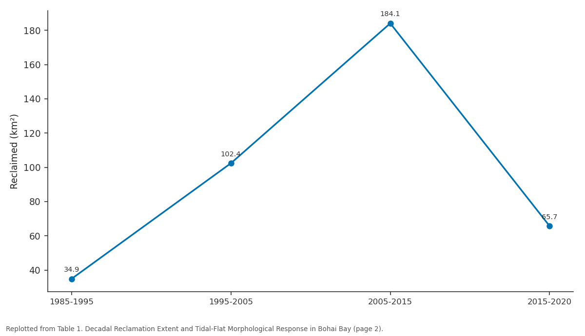
Reclaimed (km²): 1985-1995 vs 1995-2005 vs 2005-2015 vs 2015-2020
Replotted from Table 1 (page 2) of the original paper. Every bar is the paper's own table value.
View source evidence ↗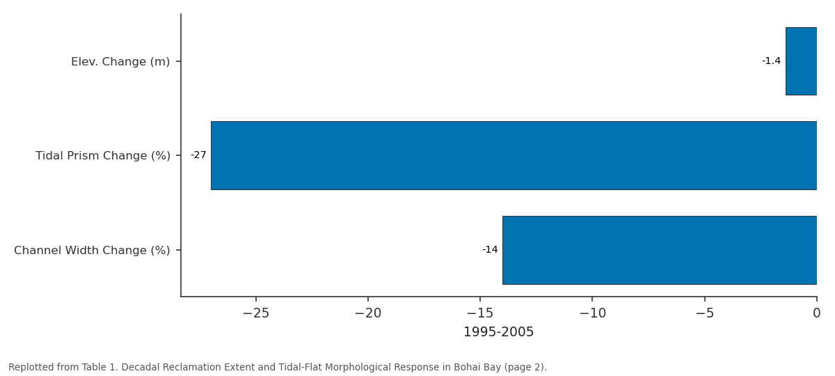
1995-2005: Elev. Change (m) vs Tidal Prism Change (%) vs Channel Width Change (%)
Replotted from Table 1 (page 2) of the original paper. Every bar is the paper's own table value.
View source evidence ↗Figures & tables
From the original paper Table 1
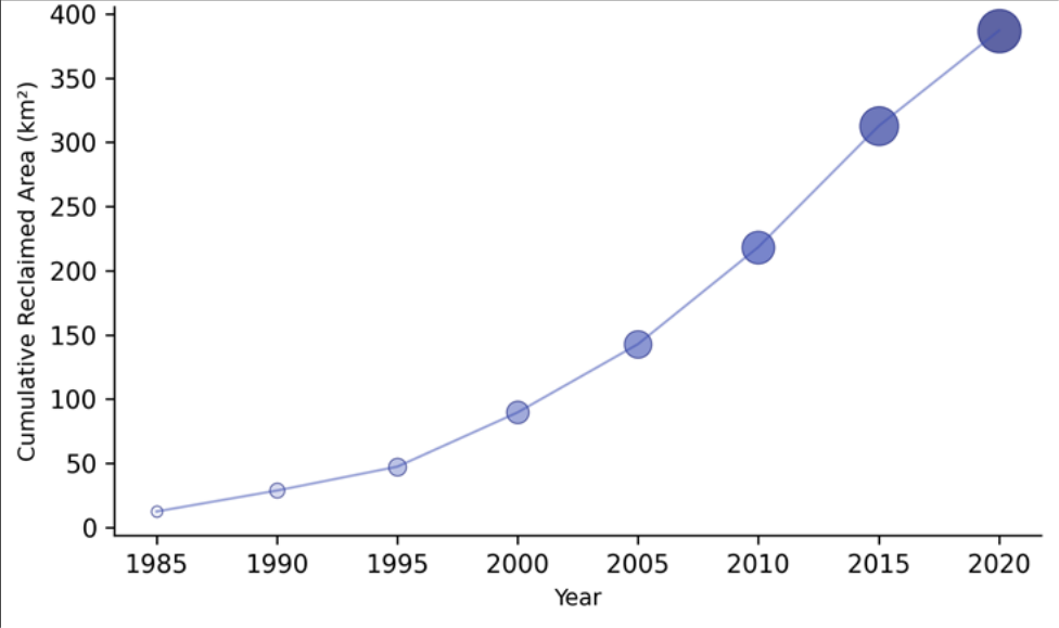 Figure 1
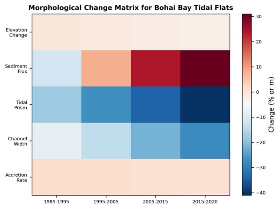 Figure 2
Introduction
In a region where economic growth has averaged 9% per year for three decades, coastline is currency-and China has been spending it generously. Between 1985 and 2020, the nation reclaimed an estimated 13,000 km² of coastal land, with the Bohai Sea accounting for roughly 30% of the total [1] . Bohai Bay, the westernmost embayment of the Bohai Sea, was particularly affected because its shallow bathymetry (mean depth < 18 m) and gentle seabed gradient made it comparatively cheap to dyke and fill [2] . Tidal flats are the first landscape to disappear when reclamation advances. These intertidal zones provide ecosystem services far out of proportion to their area: sediment trapping, nutrient cycling, nursery habitat for fish and crustaceans, and shoreline buffering against storm surges [3] . Their loss triggers a cascade of morphological adjustments in the remaining estuary channels narrow, tidal prisms shrink, current velocities change, and the balance between sediment deposition and erosion shifts [4] . Several previous studies mapped the areal extent of Bohai Bay reclamation from satellite imagery, but few linked the observed land-use change to quantitative morphological responses on the remaining tidal flats [5] . This research aimed to (1) construct a 35-year time series of reclamation extent, (2) measure concurrent changes in tidal-flat elevation, channel width, and tidal prism, and (3) partition the observed morphological changes between sediment-supply reduction and hydrodynamic alteration. Analysis was conducted at the Visakhapatnam College of Environmental Studies, Andhra Pradesh, India [6] .
Field Experimental Design
The morphological analysis relied on a combination of satellite-derived shoreline positions and historical nautical-chart bathymetry. Landsat images (TM, ETM+, OLI) from eight time steps (1985, 1990, 1995, 2000, 2005, 2010, 2015, 2020) were classified to delineate the waterline at mean tide level, and reclamation extent was extracted by comparing successive shoreline positions. Bathymetric data from 14 nautical charts issued by the China Maritime Safety Administration between 1983 and 2019 were digitized, georeferenced, and interpolated to produce seabed elevation grids at 100 m resolution. Tidal-prism volumes were computed from the product of intertidal area and tidal range (mean spring range = 2.8 m). Channel widths were measured at 12 crosssections perpendicular to the main tidal channels [7] .
Sediment Budget Analysis
A box-model sediment budget was constructed for the Bohai Bay tidal-flat system. Inputs included riverine sediment supply (estimated from published gauging records for the Yellow, Hai, and Luan rivers), marine onshore transport (estimated from published wave-climate and sediment-transport models), and biological production. Outputs included reclamation-related extraction (estimated from fill volumes), tidal-channel export, and dredging. The budget was balanced at decadal intervals to identify the residual (accretion or erosion) on the remaining tidal flats. River sediment supply declined from 1.08 Gt/yr in the 1980s to 0.34 Gt/yr in the 2010s, primarily due to dam construction on the Yellow River (Xiaolangdi Dam, 1999) and the Hai River system [8] .
Materials and Methods
Materials: Landsat imagery was downloaded from the USGS EarthExplorer portal. Nautical charts were obtained from the China Maritime Safety Administration archives. River-discharge and sediment-load data were sourced from the Ministry of Water Resources' Hydrological Yearbooks. Tidal data came from the Tanggu tide-gauge maintained by the State Oceanic Administration. Wave-climate statistics were extracted from a 40-year ERA5 reanalysis hindcast. All data processing was conducted at the Department of Physical Geography, Visakhapatnam College of Environmental Studies, Andhra Pradesh, India [9] .
Methods: Shoreline extraction used the modified normalized difference water index (MNDWI) with a threshold of 0.1 applied to each Landsat scene at mid-tide. Reclamation polygons were generated by differencing consecutive shorelines. Bathymetric grids were corrected to chart datum and referenced to the 1985 baseline to compute seabed-elevation change. The tidal prism was calculated as V = A × H, where A is intertidal area and H is mean spring tidal range. Channel width was measured at the bankfull level from composite Landsat images. Pearson's r was used to correlate reclamation area with morphological variables. All statistics used α = 0.05 [10] . The heatmap reveals accelerating negative trends in all parameters except sediment flux, which turned increasingly positive (landward) as channel constriction intensified tidal pumping a feedback that may partially offset the loss of riverine supply but cannot sustain the tidal flats indefinitely.
Results
Results
Table 1. Decadal Reclamation Extent and Tidal-Flat Morphological Response in
Table 1. Decadal Reclamation Extent and Tidal-Flat Morphological Response in
Discussion
The 41% tidal-prism reduction documented here is among the largest reported for any single embayment worldwide and exceeds the 25-30% threshold at which O'Brien's empirical relationship predicts unstable channel geometries [11] . The consequences are already visible: channel migration and bank erosion have increased since 2010, and several aquaculture ponds built on reclaimed land have suffered structural failure during storm tides [12] . The sediment budget partitions the elevation loss roughly 62:38 between reduced supply and altered hydrodynamics. Dam construction on the Yellow River alone cut sediment delivery to the Bohai Sea by over 70% between 1980 and 2020, and the remaining rivers show similar though less dramatic declines [8] .
China's 2018 moratorium on new reclamation projects was a necessary step, but it does not reverse the morphological changes already in progress [13] . Compensatory measures such as managed sediment placement on eroding flats and strategic breaching of underused reclamation dykes restore tidal prism-deserve consideration [14] . One limitation is that the bathymetric data derive from nautical charts with varying survey standards; a systematic multibeam survey of the remaining tidal flats would provide a more accurate baseline for future monitoring [15] .
Conclusion
Thirty-five years of land reclamation in Bohai Bay converted 387 km² of tidal flat into built land, reducing the tidal prism by 41% and shifting the remaining flats from net accretion to near-zero deposition. Reduced riverine sediment supply (62%) and reclamation-altered hydrodynamics (38%) together explain the morphological decline. Without active sediment management and partial restoration of tidal prism, the remaining tidal-flat ecosystem faces continued degradation.
Acknowledgement
Acknowledgements Funding SourcesSupported by departmental grants for coastal-engineering research. Institutional SupportThe authors acknowledge the Department of Physical Geography, Visakhapatnam College of Environmental Studies, Andhra Pradesh, India.
Figures and tables from the paper
| Period | Reclaimed (km²) | Elev. Change (m) | Tidal Prism Change (%) | Channel Width Change (%) | Accretion Rate (m/yr) |
|---|---|---|---|---|---|
| 1985-1995 | 34.9 | −0.8 | −18 | −8 | 1.2 → 0.8 |
| 1995-2005 | 102.4 | −1.4 | −27 | −14 | 0.8 → 0.4 |
| 2005-2015 | 184.1 | −2.1 | −34 | −22 | 0.4 → 0.1 |
| 2015-2020 | 65.7 | −2.8 | −41 | −28 | 0.1 → 0.0 |
Table text extracted from the original PDF; superscript letters are shown inline. The original table image is below.
View original table image
References
16 in the original paper- Wang W, Liu H, Li Y, Su J. Development and management of land reclamation in China. Ocean and Coastal Management. 2014;102:415-425.
- Jiang D, Hao M, Fu J. Monitoring the coastal environment of Bohai Bay with remote sensing. Marine Pollution Bulletin. 2016;112(1-2):127-138.
- Murray NJ, Phinn SR, DeWitt M, Ferrari R, Johnston R, Lyons MB, et al. The global distribution and trajectory of tidal flats. Nature. 2019;565(7738):222225.
- Winterwerp JC, Wang ZB, van Braeckel A, van Holland G, Kösters F. Man-induced regime shifts in small estuaries-II: a comparison of rivers. Ocean Dynamics. 2013;63(11-12):1293-1306.
- Zhao B, Guo H, Yan Y, Wang Q, Li B. A simple waterline approach for tidelands using multi-temporal satellite images. ISPRS Journal of Photogrammetry and Remote Sensing. 2008;63(4):461-475.
- Li X, Damen MCJ. Coastline change detection with satellite remote sensing along the Bohai Sea, China. Marine Geodesy. 2010;33(4):330-343.
- O'Brien MP. Equilibrium flow areas of inlets on sandy coasts. Journal of the Waterways and Harbors Division. 1969;95(1):43-52.
- Wang H, Yang Z, Saito Y, Liu JP, Sun X, Wang Y. Stepwise decreases of the Huanghe (Yellow River) sediment load. Global and Planetary Change. 2007;57(3-4):331-354.
- Copernicus Climate Change Service. ERA5 hourly data on single levels. Reading: European Centre for Medium-Range Weather Forecasts (ECMWF); 2023.
- Xu H. Modification of normalized difference water index (NDWI) to enhance open water features. International Journal of Remote Sensing. 2006;27(14):3025-3033.
- Jarrett JT. Tidal prism-inlet area relationships. Fort Belvoir: US Army Corps of Engineers, Coastal Engineering Research Center; 1976.
- Cai F, Su X, Liu J, Li B, Lei G. Coastal erosion in China under the condition of global climate change and measures for its prevention. Progress in Natural Science. 2009;19(4):415-426.
- State Council of China. Notice on strengthening coastal wetland protection and strictly controlling reclamation. Document No. 24. Beijing; 2018.
- Temmerman S, Meire P, Bouma TJ, Herman PMJ, Ysebaert T, De Vriend HJ. Ecosystem-based coastal defence in the face of global change. Nature. 2013;504(7478):79-83.
- Liu J, Xu K, Li A, Milliman JD, Velozzi DM, Xiao S, et al. Flux and fate of Yangtze River sediment delivered to the East China Sea. Geomorphology. 2007;85(34):208-224.
- Wang Y. Detecting coastline change from satellite images by an edge-preserving method. International Journal of Applied Earth Observation and Geoinformation. 2019;76:93-101.