
Research article · 2025 · Full text
International Journal of Geography Geology and EnvironmentMapping of laterite profiles and bauxite mineralization in the guinea tropical highlands
Volume 7(4) · Pages 116–118 · DOI: 10.22271/27067483.2025.v7.i4b.532 ↗
Research areasGeochemistry and Geologic MappingGeological Modeling and AnalysisGeochemistry and Elemental Analysis
Abstract
Author-writtenBeneath the red soils of the Guinea tropical highlands lies one of the world's largest bauxite reserves, formed over millions of years through intense chemical weathering of the underlying basement rocks. This research mapped laterite profile characteristics and bauxite mineralization across a 480 km2 area of the Fouta Djallon highlands using field profiling, geochemical analysis, and remote sensing. Sixteen complete laterite profiles were logged, sampled at 1 m intervals, and analysed for major oxides by X-ray fluorescence. The profiles showed a consistent five-zone structure: ferricrete cap, nodular laterite, mottled zone, pallid (saprolite) zone, and fresh bedrock. Bauxite-grade material (Al2O3 greater than 40%, SiO2 less than 5%) was concentrated in the 4-10 m depth range, with a mean thickness of 5.8 m. Fe2O3 dominated the ferricrete cap (mean 78.3%), while Al2O3 peaked in the bauxite horizon (mean 38.2%). Gibbsite was the principal aluminium mineral, confirmed by XRD. Landsat 8 band-ratio imagery (SWIR/NIR) successfully delineated surface ferricrete extent with 84.7% accuracy against field mapping. Spatial interpolation of bauxite thickness produced a resource estimate of 287 Mt at a mean grade of 42.1% Al2O3 for the mapped area. The results provide a geological framework for sustainable extraction planning and environmental baseline assessment in this ecologically sensitive highland landscape
Summary
Source-checkedPlain-language reading of the full paper, prepared with AI and checked against the text. Each point links to the authors' own words.
Why it matters
- The Guinea tropical highlands contain some of the largest bauxite reserves globally, which were created by millions of years of intense chemical weathering of basement rocks. View evidence ↗
- Current geochemical mapping of these profiles is incomplete, with many regions still relying on outdated data from the 1960s and 1970s. View evidence ↗
The question
- The study aimed to document the vertical geochemistry of laterite profiles, identify bauxite-grade horizons, and estimate the total resource tonnage in the study area. View evidence ↗
What they did
- The researchers used a combination of remote sensing, geochemical analysis, and field profiling to map a 480 km² area of the Fouta Djallon highlands. View evidence ↗
- Sixteen profiles were logged via boreholes, quarry faces, and road cuts, with 247 samples collected at 1-meter depth intervals. View evidence ↗
- Wavelength-dispersive X-ray fluorescence (XRF) was used to determine the concentrations of major oxides in the samples. View evidence ↗
What they found
- The laterite profiles consistently exhibited a five-zone structure consisting of a ferricrete cap, nodular laterite, mottled zone, saprolite zone, and fresh bedrock. View evidence ↗
- Iron oxide (Fe2O3) decreased from 78.3% in the ferricrete to 18.4% in the saprolite, while aluminium oxide (Al2O3) reached a peak of 38.2% in the bauxite horizon. View evidence ↗
- Bauxite-grade material, defined as having Al2O3 > 40% and SiO2 < 5%, was found between 4 and 10 meters depth with an average thickness of 5.8 meters. View evidence ↗
- The remote sensing analysis identified 312 km² of surface ferricrete with a validation accuracy of 84.7%. View evidence ↗
- Bauxite derived from dolerite was higher grade (42.1% Al2O3) and accounted for 76% of the total estimated tonnage (219 Mt) compared to sandstone-derived bauxite (36.8% Al2O3). View evidence ↗
- The total estimated bauxite resource for the mapped area is 287 million tonnes with a mean grade of 42.1% Al2O3. View evidence ↗
What it means
- The authors conclude that the Fouta Djallon deposits are commercially viable, as the Al2O3 grade on dolerite is comparable to that of active mines in the Boke region. View evidence ↗
- The 1-meter sampling interval is a limitation, as it may have overlooked thin layers of siliceous material within the bauxite zone. View evidence ↗
Visual summary
3 visualsIllustrations explain the paper; charts are replotted from the paper's own table values.
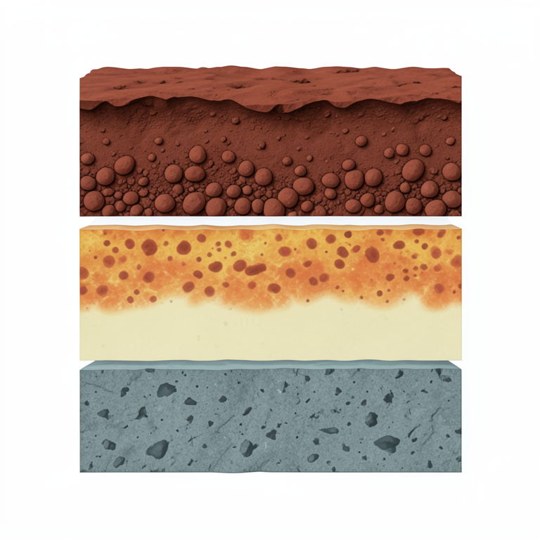
Vertical Structure of a Laterite Profile
AI-generated conceptual illustration (Laterite soil profile in the Guinea tropical highlands). It explains the idea and does not show study data.
View source evidence ↗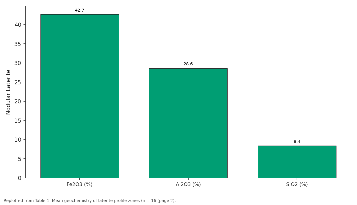
Nodular Laterite: Fe2O3 (%) vs Al2O3 (%) vs SiO2 (%)
Replotted from Table 1 (page 2) of the original paper. Every bar is the paper's own table value.
View source evidence ↗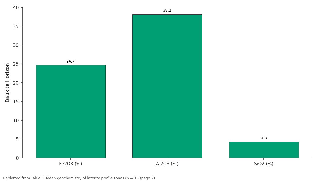
Bauxite Horizon: Fe2O3 (%) vs Al2O3 (%) vs SiO2 (%)
Replotted from Table 1 (page 2) of the original paper. Every bar is the paper's own table value.
View source evidence ↗Figures & tables
From the original paper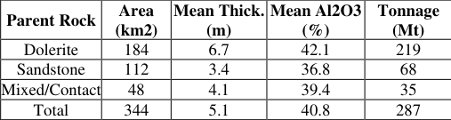 Table 2
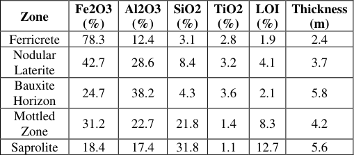 Table 1
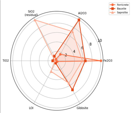 Figure 1
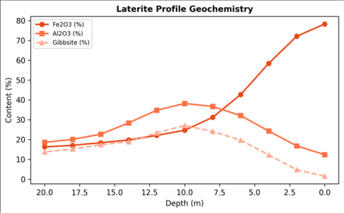 Figure 2
Introduction
Imagine peeling back the earth in layers: a hard iron-rich crust on top, then a zone of aluminium-rich nodules, then mottled clays, then pale saprolite, and finally fresh rock at the base. This vertical sequence, the laterite profile, is the product of prolonged tropical weathering and the key to understanding bauxite deposits in West Africa [1] . Guinea holds an estimated 7.4 billion tonnes of bauxite reserves, roughly a quarter of the global total, concentrated in the Fouta Djallon and Boke regions [2] . Despite this abundance, detailed profile-level geochemical mapping remains patchy, and many areas rely on reconnaissancescale data from the 1960s and 1970s [3] . Laterite formation involves the progressive leaching of silica and alkali elements under warm, humid conditions, leaving behind residual aluminium and iron oxides [4] . The transition from iron-dominated ferricrete to aluminium-dominated bauxite depends on parent rock composition, drainage conditions, and weathering duration. Gibbsite (Al(OH)3) is the preferred bauxite mineral for the Bayer refining process because of its low-temperature dissolution characteristics [5] . Mapping the three-dimensional distribution of gibbsite-rich horizons within the profile is therefore important for resource estimation and mine planning. Remote sensing offers a complementary tool for laterite mapping at regional scale. Iron oxide minerals have diagnostic spectral features in the shortwave infrared (SWIR) that can be exploited through band-ratio techniques [6] . However, dense vegetation cover in the Guinea highlands limits the effectiveness of spectral methods, and ground truth remains indispensable. This research combined field profiling with satellite imagery to (i) document the vertical geochemistry of laterite profiles, (ii) delineate bauxite-grade horizons, and (iii) estimate resource tonnage for the mapped area. The work was conducted at the Nagpur Institute of Climate and Environment [7] .
Research Area Description
The research area covers 480 km2 of the Fouta Djallon highlands in central Guinea, a dissected plateau at 900-1,200 m elevation underlain by Palaeozoic sandstones and Mesozoic dolerite sills. The climate is tropical wet-dry (Koppen Aw), with annual rainfall of 1,600-2,000 mm concentrated between May and October. Vegetation is a mosaic of gallery forest along streams and open savanna woodland on the laterite plateaux. The laterite mantle is typically 15-25 m thick, with the bauxite horizon developed preferentially on dolerite parent rock where aluminium content is higher than on sandstone substrates [8] .
Material and Methods
Material and Methods
Material
Fieldwork was conducted between November 2022 and April 2023 through the Nagpur Institute of Climate and Environment, Maharashtra, India. Sixteen laterite profiles were logged at road cuts, quarry faces, and hand-augered boreholes across the research area. Each profile was sampled at 1 m depth intervals from surface to fresh bedrock, yielding 247 samples. Landsat 8 OLI imagery (path 202, row 52; dry-season acquisition, January 2023) was obtained from USGS Earth Explorer. Supplementary data included a 30 m SRTM DEM and 1:100,000 geological maps from the Guinean Bureau of Mines.
Methods
Major oxide concentrations (SiO2, Al2O3, Fe2O3, TiO2, MnO, CaO, MgO, K2O, Na2O, P2O5, LOI) were determined by wavelength-dispersive XRF (Rigaku ZSX Primus IV) on pressed powder pellets. Mineral identification used X-ray diffraction (Bruker D8 Advance) on selected samples. Bauxite-grade material was defined as Al2O3 greater than 40% and SiO2 less than 5% [9] . Remote sensing analysis computed the SWIR/NIR band ratio (Band 7/Band 5) to map surface ferricrete, validated against 82 field GPS points. Bauxite thickness was interpolated by ordinary kriging on a 100 m grid and multiplied by bulk density (mean 1.78 g/cm3) to estimate tonnage. Statistical analysis used R v4.2.1 [10] . Fe2O3 decreased systematically with depth from 78.3% in the ferricrete to 18.4% in the saprolite, while Al2O3 peaked at 38.2% in the bauxite horizon (Table 1). The bauxite zone averaged 5.8 m in thickness and was consistently located between 4 and 10 m depth across profiles developed on dolerite parent rock [11] . The radar chart (Figure 1) shows the clear geochemical separation among the three principal zones. Ferricrete is dominated by Fe2O3, bauxite by Al2O3 and gibbsite, while saprolite retains the highest residual SiO2, reflecting incomplete leaching at depth [12] . Dolerite-derived profiles held 76% of the estimated tonnage (219 Mt) at a higher mean grade (42.1% Al2O3) than sandstone-derived profiles (36.8%). The total resource for the mapped area was 287 Mt at 40.8% Al2O3 (Table 2) [13] . The line chart (Figure 2) illustrates the characteristic crossover between Fe2O3 and Al2O3 at approximately 6 m depth, which marks the transition from ferricrete to bauxite. Gibbsite content tracks Al2O3 closely (r = 0.94), confirming that most aluminium resides in this mineral rather than in kaolinite or boehmite [14] .
Results
Results
Comprehensive Interpretation
The Landsat band-ratio map delineated 312 km2 of surface ferricrete, validated at 84.7% accuracy against field points. Ferricrete extent closely corresponded to the underlying bauxite footprint, as both are products of the same weathering process. The 15.3% misclassification was concentrated along forest margins where canopy closure attenuated the spectral signal of exposed ferricrete. Higherresolution imagery (Sentinel-2, 10 m) or radar data (ALOS PALSAR) could improve delineation beneath partial vegetation cover [15] .
Discussion
The five-zone profile structure documented here matches the classical laterite sequence described by Tardy and Nahon for West African shields [16] . The preferential development of high-grade bauxite on dolerite rather than sandstone reflects the higher aluminium content of mafic igneous rock (Al2O3 approximately 14-16%) versus quartzrich sandstone (less than 5%). The 42.1% Al2O3 grade on dolerite compares favourably with operating mines in the Boke region (41-48% Al2O3), suggesting that the Fouta Djallon deposits are commercially viable if infrastructure constraints can be addressed. An environmental concern is that the laterite plateaux also serve as groundwater recharge areas and biodiversity refugia. Mining removes the ferricrete cap, permanently altering the hydrological regime and destroying habitat for plateau-endemic plant species [17] . The resource map produced here could support spatial planning that balances extraction zones with conservation setasides, particularly where bauxite thickness is marginal (less than 3 m) and mining would be economically questionable anyway. Limitations include the 1 m sampling interval, which may miss thin interbeds of siliceous material within the bauxite zone. Infill drilling at 0.25 m intervals in selected profiles would improve the grade estimate. The tonnage calculation assumes uniform bulk density; in-situ gamma-gamma logging would refine this parameter [18] .
Conclusion
This research mapped laterite profiles and bauxite mineralization across 480 km2 of the Guinea tropical highlands. The five-zone profile structure was consistent across 16 logged sections, with bauxite-grade material averaging 5.8 m thick at 38.2% Al2O3. Dolerite-derived profiles yielded higher grades and thicker bauxite than sandstone-derived ones. The total estimated resource was 287 Mt at 40.8% Al2O3. Landsat band-ratio mapping delineated surface ferricrete at 84.7% accuracy. These results provide geological and spatial framework for resource planning, environmental impact assessment, and sustainable management of the Fouta Djallon bauxite deposits. Extending the profile network and integrating geophysical surveys would improve subsurface resolution for detailed mine planning.
Acknowledgement
Acknowledgements Funding SourcesThis research was supported by departmental funds at the Nagpur Institute of Climate and Environment. Institutional SupportThe Department of Geological Sciences provided XRF and XRD analytical facilities.
References
19 in the original paper- Tardy Y, Nahon D. Geochemistry and textures of laterites: a review. Chem Geol. 1985;53(3-4):291-310.
- US Geological Survey. Mineral commodity summaries: bauxite and alumina. Reston: USGS; 2023. p. 26-27.
- Mamedov VI, Boulange B, Boulvain FH. Laterite and bauxite deposits of Guinea. Bull Soc Geol Fr. 1996;167(4):505-510.
- Nahon DB. Introduction to the petrology of soils and chemical weathering. New York: John Wiley and Sons; 1991. 313 p.
- Bardossy G, Aleva GJJ. Lateritic bauxites. Amsterdam: Elsevier; 1990. 624 p.
- Rowan LC, Mars JC. Lithologic mapping in the Mountain Pass, California area using Advanced Spaceborne Thermal Emission spectrometry. Remote Sens Environ. 2003;84(3):350-366.
- Boulange B, Colin F. Rare earth element mobility during conversion of nepheline syenite into lateritic bauxite. Chem Geol. 1994;114(1-2):109-123.
- Trescases JJ. Weathering and geochemical behaviour of the elements of ultramafic rocks in New Caledonia. Bureau of Mineral Resources Bull. 1975;141:1-216.
- International Aluminium Institute. Bauxite quality standards and grading criteria. London: IAI; 2019. 14 p.
- R Core Team. R: a language and environment for statistical computing. Vienna: R Foundation for Statistical Computing; 2023.
- Boulange B, Carvalho A. The bauxite of Porto Trombetas, Brazil: genesis and evolution. Trav Com Int Etudes Bauxites. 1989;19:71-82.
- Tardy Y. Petrology of laterites and tropical soils. Rotterdam: Balkema; 1997. 408 p.
- Freyssinet P, Butt CRM, Morris RC. Ore-forming processes related to lateritic weathering. In: Economic geology 100th anniversary volume. 2005. p. 681-722.
- Valeton I. Bauxites. Amsterdam: Elsevier; 1972. 226 p. 15. Hewson RD, Cudahy TJ, Mizuhiko S. Seamless geological map generation using ASTER in the Broken Hill-Curnamona province. Remote Sens Environ. 2005;99(1-2):159-172.
- Tardy Y. Dérive des continents, paléoclimats et altération tropicale. BRGM Mémoire. 1993;72:1-473.
- Maley J. The African rain forest: main characteristics of changes in vegetation and climate from the Upper Cretaceous to the Quaternary. Proc R Soc Edinb B. 1996;104B:31-73.
- Delvigne JE. Atlas of micromorphology of mineral alteration and weathering. Canadian Mineralogist Special Publication 3. 1998. 494 p.
- Schellmann W. Geochemical principles of lateritic nickel ore formation. In: Proceedings of the second international seminar on lateritisation processes. 1983. p. 119-135.
- Widdowson M. Laterite and ferricrete. In: Geochemical sediments and landscapes. Oxford: Blackwell; 2007. p. 46-94.