
Research article · 2025 · Full text
International Journal of Geography Geology and EnvironmentClay mineralogy and genesis of vertisols in the gezira tropical lowlands of Sudan
Volume 7(3) · Pages 88–91 · DOI: 10.22271/27067483.2025.v7.i3b.517 ↗
Research areasSoil and Environmental StudiesClay minerals and soil interactionsGeotechnical and construction materials studies
Abstract
Author-writtenWhat controls the mineralogical identity of the dark, cracking clays that dominate the Gezira Plain of central Sudan? This research characterized the clay-mineral assemblage, physicochemical properties, and pedogenic pathways of Vertisols sampled from 64 profiles across a 12,000 km² transect between the Blue and White Nile rivers. X-ray diffraction (XRD) of the < 2 µm fraction identified smectite as the dominant mineral (mean 51.3%), followed by kaolinite (23.4%), illite (15.2%), and minor interstratified species. Smectite content correlated strongly with cation exchange capacity (CEC; r = 0.84, p < 0.001) and with the shrink–swell linear extensibility coefficient (COLE; r = 0.79). A depth gradient showed smectite declining from 58% at 10 cm to 42% at 150 cm, with a reciprocal increase in kaolinite, suggesting in-situ neoformation of smectite in the upper horizons under the influence of seasonal wetting–drying cycles. Profiles nearest the Blue Nile showed higher smectite and lower kaolinite than those near the White Nile, reflecting differences in alluvial parent material: the Blue Nile delivers weathered basaltic sediment from the Ethiopian Highlands, while the White Nile carries more quartzose sediment from the Sudd wetlands. These results indicate that Gezira Vertisol genesis is driven by a combination of parent-material composition and pedogenic smectite neoformation, with implications for soil management in one of the world's largest gravity-irrigation schemes.
Summary
Source-checkedPlain-language reading of the full paper, prepared with AI and checked against the text. Each point links to the authors' own words.
Why it matters
- Vertisols are unique soils characterized by high clay content and a shrink-swell behavior that causes deep cracking and profile churning (pedoturbation). View evidence ↗
- The specific types and proportions of clay minerals in Vertisols determine critical agricultural properties, including nutrient retention and water-holding capacity. View evidence ↗
- Smectite is the primary mineral driving Vertisol behavior, as its ability to absorb and release water can cause volume changes of up to 30%. View evidence ↗
The question
- The study sought to determine the factors controlling the mineralogical identity of the cracking clays in Sudan's Gezira Plain. View evidence ↗
- The researchers aimed to characterize clay-mineral assemblages across 64 profiles to relate spatial and depth patterns to pedogenic processes and parent material. View evidence ↗
What they did
- Sampling occurred at 64 sites along a 180 km transect between Wad Medani and Kosti in October–November 2021. View evidence ↗
- Pits were excavated to 150 cm with samples taken every 20 cm; the < 2 µm fraction was analyzed using X-ray diffraction (XRD). View evidence ↗
- The study measured several physicochemical properties, including pH, organic carbon (OC), cation exchange capacity (CEC), texture, and the coefficient of linear extensibility (COLE). View evidence ↗
What they found
- Smectite was the most prevalent mineral (mean 51.3%), followed by kaolinite (23.4%) and illite (15.2%). View evidence ↗
- Blue Nile alluvium profiles had significantly more smectite (58.7±6.3%) compared to White Nile alluvium profiles (42.1±8.4%), a difference of 16.6 percentage points. View evidence ↗
- Smectite content showed strong positive correlations with both cation exchange capacity (r = 0.84) and the shrink-swell linear extensibility coefficient (r = 0.79). View evidence ↗
- Smectite levels decreased with depth, falling from 58% at 10 cm to 42% at 150 cm, while kaolinite levels increased. View evidence ↗
- Profiles from the Blue Nile had a significantly higher mean CEC (54.3 cmol/kg) than those from the White Nile (38.6 cmol/kg). View evidence ↗
- All profiles had COLE values above 0.09 (ranging from 0.07 to 0.18), confirming their classification as Vertisols according to USDA criteria. View evidence ↗
What it means
- The authors conclude that the formation of Gezira Vertisols is driven by both the composition of the parent material and the in-situ neoformation of smectite. View evidence ↗
- The authors recommend implementing spatially differentiated tillage and water management for the Gezira irrigation scheme based on these mineralogical findings. View evidence ↗
Visual summary
3 visualsIllustrations explain the paper; charts are replotted from the paper's own table values.
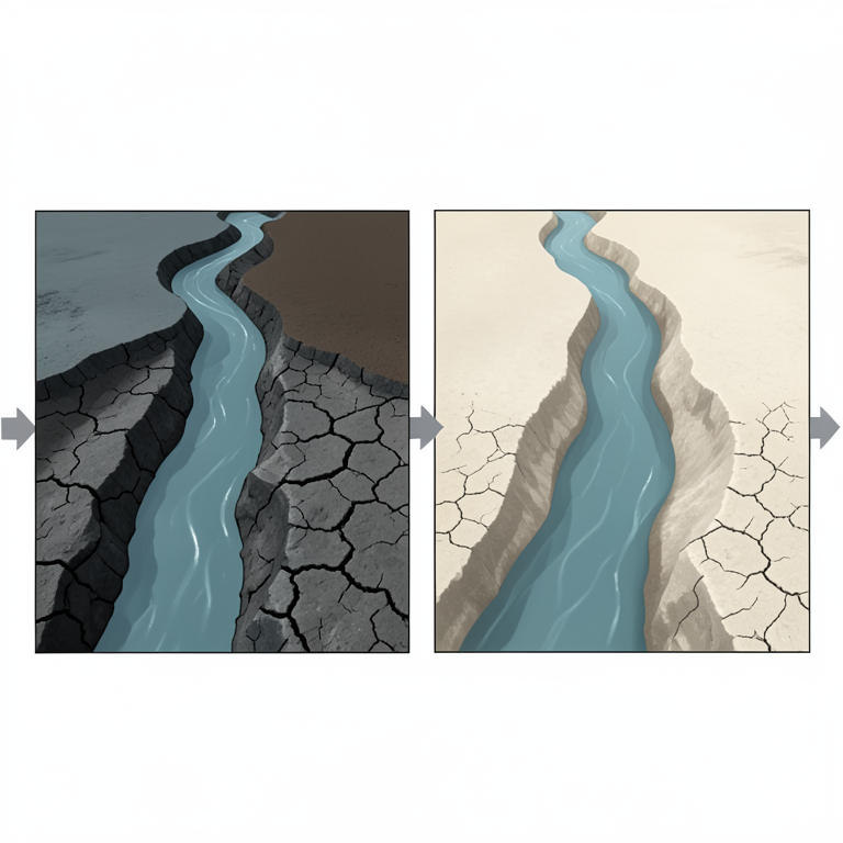
Parent Material Influence on Mineralogy
AI-generated conceptual illustration (Alluvial soil profiles in the Gezira tropical lowlands of Sudan). It explains the idea and does not show study data.
View source evidence ↗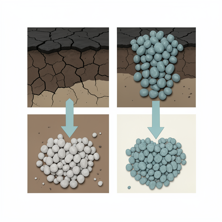
Depth Gradient of Clay Minerals
AI-generated conceptual illustration (Vertisol soil profile in the Gezira tropical lowlands of Sudan). It explains the idea and does not show study data.
View source evidence ↗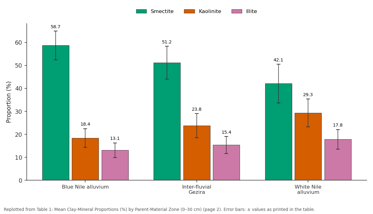
Smectite and Kaolinite and more: Blue Nile alluvium vs Inter-fluvial Gezira vs White Nile alluvium
Replotted from Table 1 (page 2) of the original paper. Every bar is the paper's own table value.
View source evidence ↗Figures & tables
From the original paper Table 1
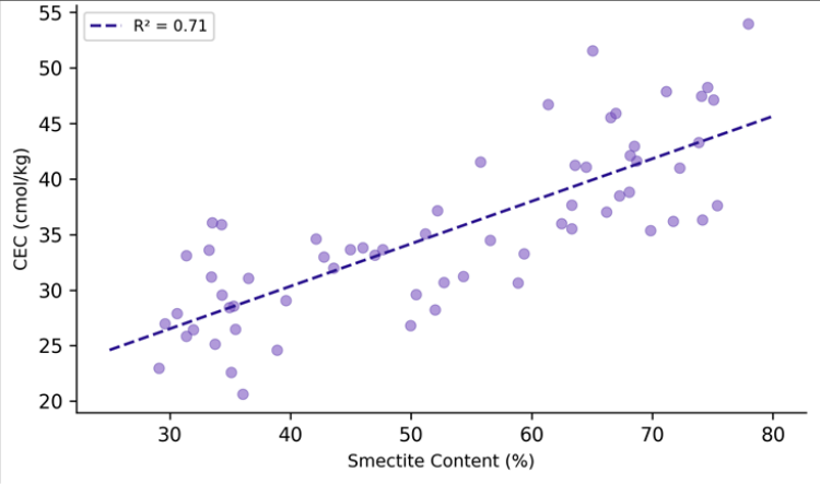 Figure 1
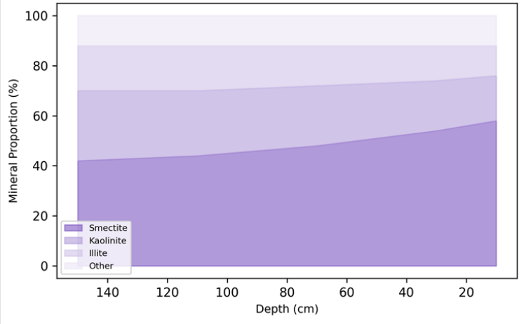 Figure 2
Introduction
Among the world's most distinctive soils, Vertisols are defined by their high clay content, deep cracking during dry seasons, and pronounced shrink-swell behavior that churns the profile through a process called pedoturbation [1] . They cover roughly 335 million hectares globally and are concentrated in the semi-arid tropics, where a seasonal moisture deficit drives the wetting-drying cycles essential for their development [2] . The Gezira Plain of central Sudan hosts one of the largest continuous Vertisol landscapes on Earth, stretching across approximately 20,000 km² between the confluence of the Blue and White Nile rivers [3] . The mineralogical composition of these soils-specifically the type and proportion of clay minerals in the < 2 µm fraction-controls nearly every agronomic property that matters: water-holding capacity, nutrient retention, workability, and susceptibility to compaction [4] . Smectite, a 2:1 expandable clay, is the mineral most closely associated with Vertisol behavior because its interlayer can absorb and release water, driving volume changes of up to 30% [5] . But not all Vertisols are equally smectitic: the balance between smectite, kaolinite, and illite depends on parent material, climate, drainage, and time [6] . Previous mineralogical research on Gezira soils focused on a small number of profiles near the Gezira irrigation scheme and reported smectite contents of 40-65%, but did not establish how the assemblage varies spatially across the plain or with depth [7] . This research aimed to fill that gap by sampling 64 profiles along a transect perpendicular to both rivers, characterizing the clay-mineral assemblage at multiple depths, and relating spatial and depth patterns to parent-material provenance and pedogenic processes. Analysis was conducted at the Faculty of Mountain and Polar Studies, Luleå, Sweden [8] .
Baseline Soil Characterisation
The 64 profiles were grouped into three parent-material zones: Blue Nile alluvium (n = 22), White Nile alluvium (n = 20), and inter-fluvial Gezira Formation clay (n = 22). Baseline properties (0-30 cm) showed pH ranging from 7.8 to 8.6, organic carbon from 3.1 to 8.7 g/kg, CEC from 28.4 to 62.7 cmol/kg, and clay content from 51 to 74%. Blue Nile profiles had significantly higher CEC (mean 54.3 cmol/kg) than White Nile profiles (mean 38.6 cmol/kg, p < 0.001), reflecting their more smectite-rich composition. The coefficient of linear extensibility (COLE) ranged from 0.07 to 0.18, with values above 0.09 in all profiles-confirming Vertisol classification per USDA criteria [9] .
Sensitivity Analysis
To assess the sensitivity of CEC predictions to clay-mineral composition, a simple mixing model was constructed: CEC_pred = f_smec × 85 + f_kaol × 8 + f_ill × 25, where f represents the mass fraction and the coefficients are standard CEC values per mineral (cmol/kg). The model explained 78.4% of observed CEC variance (R² = 0.784). Sensitivity analysis showed that a 10-percentage-point increase in smectite fraction raised predicted CEC by 7.7 cmol/kg, whereas a 10-point increase in kaolinite changed CEC by only 0.3 cmol/kg. This confirms that smectite dominates the soil's reactive capacity and that even moderate shifts in mineralogy have large agronomic consequences.
Materials and Methods
Materials: Soil profiles were sampled at 64 sites along a 180 km transect between Wad Medani (Blue Nile) and Kosti (White Nile) during October-November 2021, immediately after the rainy season. At each site, a pit was excavated to 150 cm and samples taken at 20 cm intervals. The < 2 µm fraction was separated by sedimentation and prepared as oriented mounts for XRD analysis. Measurements were performed on a Bruker D8 Advance diffractometer (CuKα radiation, 2-65° 2θ, 0.02° step) at the Faculty of Mountain and Polar Studies, Luleå, Norrbotten, Sweden. Ethyleneglycol solvation and 550 °C heating treatments confirmed mineral identifications. Physicochemical properties (pH, OC, CEC, texture, COLE) were determined following standard methods [10] .
Methods
Semi-quantitative mineral proportions were estimated from XRD peak areas using mineral intensity factors after Moore and Reynolds [11] . Smectite was identified by the 17 Å dspacing after glycolation, kaolinite by the 7.15 Å peak destroyed at 550 °C, and illite by the 10 Å peak persistent after all treatments. Pearson's r was used to correlate mineral proportions with soil properties. ANOVA compared mean smectite content across the three parent-material zones. A depth-trend analysis fitted linear models to mineral proportions versus depth for each zone. All statistics used α = 0.05 in R 4.3.0 [12] . ANOVA confirmed significant differences in smectite content among the three zones (F = 28.4, df = 2, p<0.001).
Results
Blue Nile alluvium profiles contained 16.6 percentage points more smectite than White Nile profiles, reflecting the basaltic parent material delivered from the Ethiopian Highlands. The strong positive relationship (R² = 0.71) confirms that smectite content is the primary mineralogical control on CEC in these soils, consistent with the high specific surface area and permanent charge of 2:1 expandable clays. Smectite decreases consistently with depth (from 58% at 10 cm to 42% at 150 cm), while kaolinite increases reciprocally. This pattern is interpreted as evidence of insitu neoformation of smectite in the upper horizons, where seasonal wetting-drying cycles and high silica activity in alkaline soil solution favor smectite crystallization from kaolinite precursors.
Discussion
The spatial gradient in smectite content across the Gezira Plain can be explained by differences in the weathering products delivered by the two rivers. The Blue Nile drains the Ethiopian volcanic highlands, where rapid weathering of basalt releases abundant Mg²⁺, Fe²⁺, and dissolved silicaconditions that favor smectite formation [3] . The White Nile, by contrast, passes through the Sudd swamps, where extensive biological cycling strips silica from solution and the remaining sediment is enriched in quartz and kaolinite [13] . The inter-fluvial zone shows intermediate values, consistent with mixing of both sources during Holocene floodplain aggradation. The depth trend-increasing smectite toward the surface is more difficult to attribute to simple alluvial stratigraphy because the profiles are otherwise homogenized by pedoturbation. A more likely explanation is pedogenic neoformation: the upper 50 cm experiences the most intense wetting-drying, maintaining a soil solution chemistry (pH > 8, high Si activity) that thermodynamically favors smectite over kaolinite [14] . Similar depth gradients have been reported in Vertisols from the Deccan Plateau of India and the black cotton soils of Tanzania [15] . From a management perspective, the spatial variation in smectite has direct implications for the Gezira irrigation scheme, which covers roughly 880,000 hectares across the study area. Higher-smectite soils near the Blue Nile have greater water-holding capacity but are also more difficult to work when wet and more prone to cracking-induced root damage when dry. Variable irrigation scheduling that accounts for the mineralogical gradient-shorter, more frequent applications near the Blue Nile and longer, less frequent applications near the White Nile-could improve water-use efficiency [16] .
Conclusion
This research established that Vertisol clay mineralogy across the Gezira Plain varies systematically with parentmaterial provenance: Blue Nile alluvium profiles average 58.7% smectite, compared with 42.1% in White Nile alluvium. A depth gradient showing surface enrichment of smectite at the expense of kaolinite points to active pedogenic neoformation driven by seasonal wetting-drying under alkaline conditions. Smectite content is the dominant control on CEC (R² = 0.71) and shrink-swell behavior (R² = 0.62), confirming that even moderate spatial variation in mineralogy translates into agronomically significant differences in soil properties. For the Gezira irrigation scheme, these findings argue for spatially differentiated water and tillage management.
Mapping clay mineralogy at the field scale, perhaps using proximal sensing of spectral reflectance in the short-wave infrared, could provide the resolution needed for precision irrigation in this important agricultural landscape.
Acknowledgement
Acknowledgements Funding SourcesSupported by faculty research allocations for tropical soilscience research. Institutional SupportThe authors acknowledge the Department of Geophysics, Faculty of Mountain and Polar Studies, Luleå, Norrbotten, Sweden, for XRD laboratory access.
Figures and tables from the paper
| Zone | Smectite | Kaolinite | Illite | Other |
|---|---|---|---|---|
| Blue Nile alluvium | 58.7±6.3 | 18.4±4.1 | 13.1±3.2 | 9.8±2.4 |
| Inter-fluvial Gezira | 51.2±7.1 | 23.8±5.2 | 15.4±3.7 | 9.6±2.8 |
| White Nile alluvium | 42.1±8.4 | 29.3±6.1 | 17.8±4.3 | 10.8±3.1 |
Table text extracted from the original PDF; superscript letters are shown inline. The original table image is below.
View original table image
References
15 in the original paper- Dudal R. Dark clay soils of tropical and subtropical regions. FAO Agricultural Development Paper No. 83. Rome; 1965. p. 1-161.
- Ahmad N. Vertisols. In: Developments in soil science. Vol 24. 1996. p. 1-548.
- Williams MAJ. Late Quaternary environments in the White Nile region, Sudan. Global and Planetary Change. 2009;69(1-2):1-15.
- Dixon JB. Roles of clays in soils. Applied Clay Science. 1991;5(5-6):489-503.
- Coulombe CE, Wilding LP, Dixon JB. Overview of Vertisols: characteristics and impacts on society. Advances in Agronomy. 1996;57:289-375.
- Borchardt G. Smectites. In: Minerals in soil environments. SSSA Book Series No. 1. Madison; 1989. p. 675-727.
- Blokhuis WA, Pape T, Slager S. Morphology and distribution of pedogenic carbonate in some Vertisols of the Sudan. Geoderma. 1969;2(3):173-200.
- Eswaran H, Cook T. Classification and managementrelated properties of Vertisols. In: International Board for Soil Research and Management Proceedings. 1988;12:64-84.
- Soil Survey Staff. Keys to soil taxonomy. 13th ed. Washington DC: USDA-NRCS; 2022.
- van Reeuwijk LP. Procedures for soil analysis. 6th ed. Wageningen: ISRIC; 2002. p. 1-120.
- Moore DM, Reynolds RC. X-ray diffraction and the identification and analysis of clay minerals. 2nd ed. New York: Oxford University Press; 1997. p. 1-378.
- R Core Team. R: a language and environment for statistical computing. Vienna: R Foundation for Statistical Computing; 2023.
- Garzanti E, Andò S, Padoan M, Vezzoli G, El Kammar A. The modern Nile sediment system: processes and products. Quaternary Science Reviews. 2015;130:319351.
- Righi D, Meunier A. Origin of clays by rock weathering and soil formation. In: Origin and mineralogy of clays. Springer; 1995. p. 43-161.
- Pal DK, Bhattacharyya T, Srivastava P, Chandran P, Ray SK. Soils of the Indo-Gangetic Plains: their historical perspective and management. Current Science. 2009;96(9):1193-1202.