
Research article · 2025 · Full text
International Journal of Geography Geology and EnvironmentVegetation recovery monitoring after wildfire using multi-temporal imagery in Mediterranean Spain
Volume 7(3) · Pages 84–87 · DOI: 10.22271/27067483.2025.v7.i3b.516 ↗
Research areasFire effects on ecosystemsRemote Sensing in AgricultureRangeland and Wildlife Management
Abstract
Author-writtenMediterranean ecosystems are adapted to periodic fire, but the pace of post-fire vegetation recovery varies widely depending on fire severity, pre-fire community composition, and post-fire rainfall. This research tracked vegetation recovery within a 4,820-hectare burn scar produced by the August 2017 wildfire near Bolbaite in the Valencia region of eastern Spain, using a Sentinel-2 time series spanning 60 months post-fire. The normalized difference vegetation index (NDVI) was computed at roughly monthly intervals and used to construct recovery trajectories for three pre-fire vegetation types: Aleppo pine (Pinus halepensis) forest, Mediterranean shrubland (matorral), and mixed pine–oak woodland. Mean NDVI dropped from a pre-fire baseline of 0.68 to 0.12 immediately after the fire. Mediterranean shrubland recovered fastest, reaching 94.1% of its pre-fire NDVI by month 60, while pine forest reached only 89.7%. A breakpoint analysis identified two distinct recovery phases: an initial rapid greening phase (0–18 months) driven by herbaceous and resprouting shrub cover, and a slower structural recovery phase (18–60 months) associated with canopy closure. Fire severity, indexed by the differenced normalized burn ratio (dNBR), was the strongest predictor of 60-month NDVI recovery (β = −0.47, p<0.001). These findings support the use of Sentinel-2 time series as a cost-effective tool for post-fire monitoring and can inform decisions about whether and where to invest in active reforestation versus natural regeneration.
Summary
Source-checkedPlain-language reading of the full paper, prepared with AI and checked against the text. Each point links to the authors' own words.
Why it matters
- Wildfires are a recurring summer event in the Mediterranean Basin, with Spain experiencing the highest proportion of the average 450,000 hectares burned annually in southern Europe. View evidence ↗
- Pine-dominated forests can take 15 to 30 years for full canopy recovery, leaving the land susceptible to repeat fires, invasive species, and erosion in the meantime. View evidence ↗
- The Sentinel-2 satellite constellation provides 10-meter resolution imagery every five days, offering significantly better spatial and temporal detail for fire ecology research than previous tools. View evidence ↗
The question
- The study aimed to create NDVI recovery trajectories for three vegetation types in the 2017 Bolbaite burn scar, find the timing of recovery phase transitions, and determine if topography and fire severity predict recovery after 60 months. View evidence ↗
What they did
- The researchers monitored a 4,820-hectare burn scar from an August 2017 wildfire near Bolbaite, Spain, using Sentinel-2 imagery over a 60-month period. View evidence ↗
- BFAST analysis was used on pixel-level NDVI data to identify the specific time points when recovery transitioned from herbaceous growth to woody growth. View evidence ↗
What they found
- Immediately following the fire, the mean NDVI decreased from a pre-fire baseline of 0.68 to 0.12. View evidence ↗
- By the 60th month, Mediterranean shrubland showed the fastest recovery at 94.1% of pre-fire NDVI, compared to 89.7% for pine forests. View evidence ↗
- Fire severity (dNBR) was the most significant predictor of recovery after 60 months, with a coefficient of β = −0.47 (p < 0.001). View evidence ↗
What it means
- The authors recommend a differentiated management strategy: allowing natural regeneration for low-severity shrublands while prioritizing active restoration for high-severity pine sites on steep slopes. View evidence ↗
- A limitation of the study is that NDVI can saturate at high biomass levels, which may lead to an underestimation of recovery in dense shrublands with a leaf-area index over 3.0. View evidence ↗
Visual summary
1 visualsIllustrations explain the paper; charts are replotted from the paper's own table values.
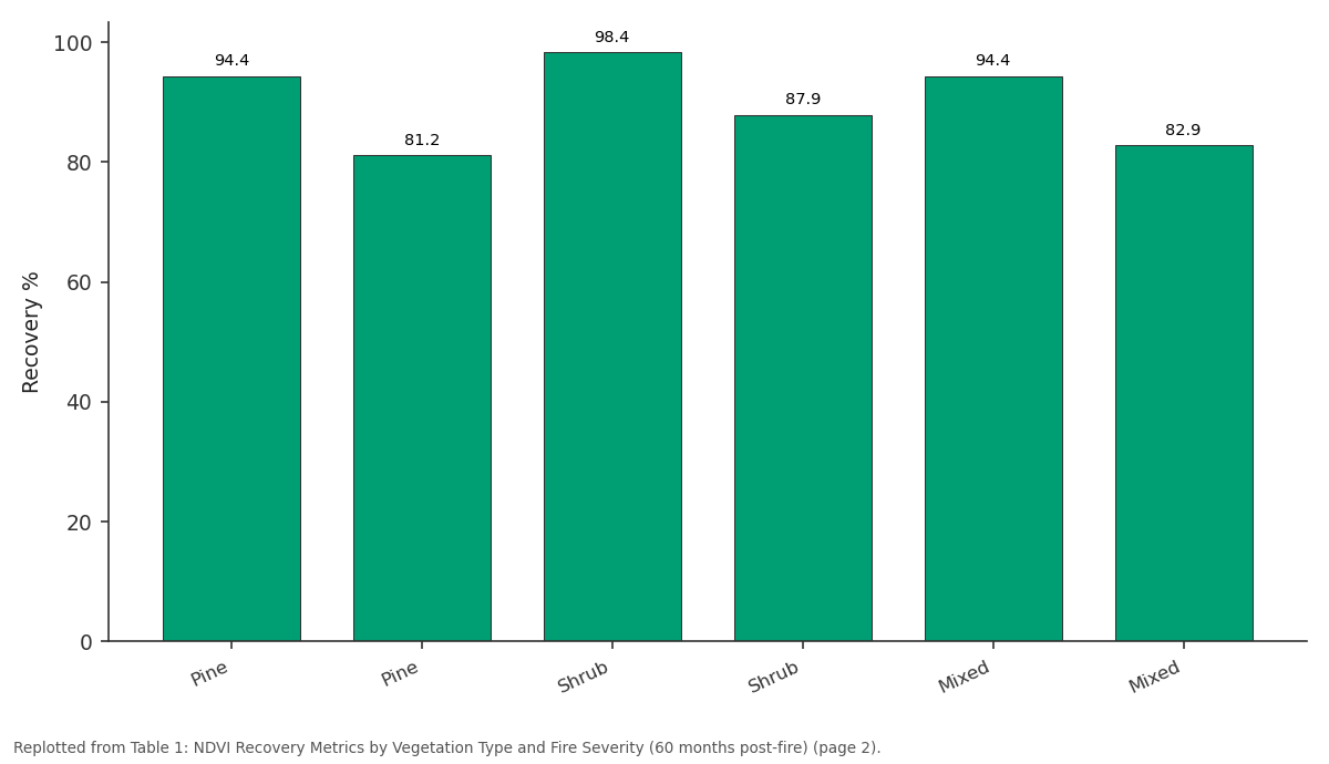
Recovery %: Pine vs Pine vs Shrub vs Shrub vs Mixed
Replotted from Table 1 (page 2) of the original paper. Every bar is the paper's own table value.
View source evidence ↗Figures & tables
From the original paper Table 1
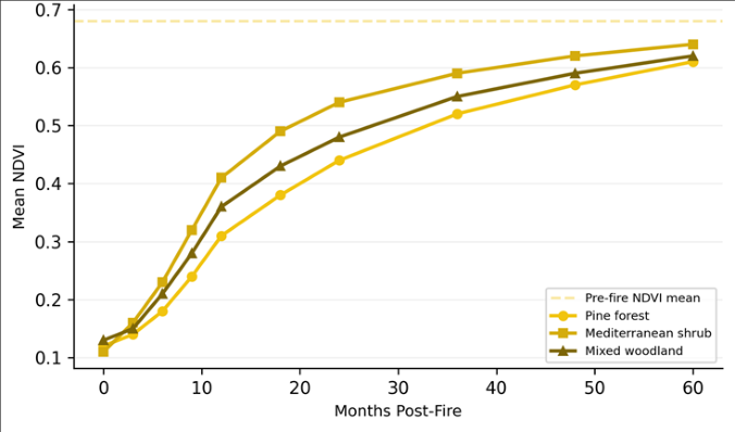 Figure 1
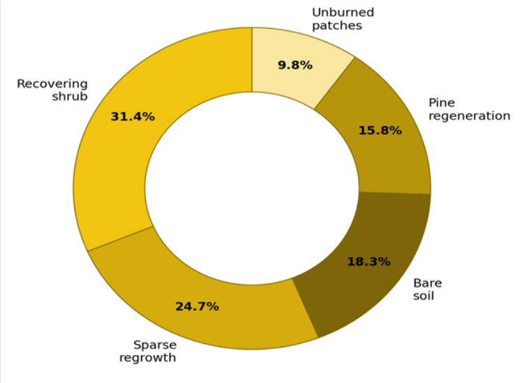 Figure 2
Introduction
Every summer, fire sweeps across the Mediterranean Basin-over 450,000 hectares burn in an average year across southern Europe, with Spain consistently accounting for the largest share [1] . The ecological role of fire in these landscapes is well established: many Mediterranean plant species possess adaptive traits such as serotinous cones, lignotubers, and fire-stimulated germination that allow rapid post-fire recovery [2] . But 'rapid' is a relative term. Full canopy recovery in pine-dominated stands can take 15-30 years, and during the intervening window the landscape is vulnerable to erosion, invasive species colonization, and repeat fire [3] . Remote sensing offers a practical way to monitor recovery across large burn scars at regular intervals without costly field campaigns. The NDVI, calculated from red and near-infrared reflectance bands, is the most widely used spectral index for tracking vegetation greenness and has been shown to correlate well with above-ground biomass and leaf-area index in Mediterranean shrublands and forests [4] . The launch of the Sentinel-2 constellation in 2015, providing 10 m resolution imagery every five days, represented a step change in the spatial and temporal detail available for fire-ecology research [5] . Previous post-fire recovery assessments in Spain have used Landsat at 30 m resolution, but the coarser pixel size limits the ability to distinguish fine-scale spatial patterns driven by slope aspect, soil depth, and micro-topographic moisture availability [6] . Sentinel-2's 10 m bands can resolve these drivers at the hillslope scale, and its free, open-data policy makes long-term monitoring operationally feasible. This research aimed to (1) construct NDVI recovery trajectories for three vegetation types within the 2017 Bolbaite burn scar, (2) identify temporal breakpoints separating recovery phases, and (3) test whether fire severity and topographic variables predict the degree of recovery at 60 months post-fire. Analysis was performed at the Piura National University of Earth Sciences, Peru [7] .
Spatial Data Processing
A total of 58 cloud-free Sentinel-2 Level-2A scenes covering the Bolbaite burn scar (tiles 30SYJ and 30SXJ) were downloaded from the Copernicus Open Access Hub for the period August 2017 through August 2022. Scenes with cloud cover exceeding 20% over the burn perimeter were discarded. Atmospheric correction was already applied in the Level-2A product (Sen2Cor processor). NDVI was computed from Band 4 (red, 10 m) and Band 8 (NIR, 10 m) as NDVI = (B8 -B4) / (B8 + B4). The differenced normalized burn ratio (dNBR) was calculated from pre-fire (July 2017) and immediate post-fire (September 2017) scenes using Bands 8A and 12 at 20 m resolution, resampled to 10 m. The burn perimeter was delineated by thresholding dNBR > 0.1, producing a scar of 4,820 hectares [8] .
Classification and Validation: Pre-fire vegetation types were classified from the July 2017 Sentinel-2 scene using a random-forest classifier (300 trees) trained on 480 reference points derived from the Spanish National Forest Inventory (IFN4) plot database and photo-interpreted from PNOA orthophotography. Three classes were mapped: Aleppo pine forest, Mediterranean shrubland (matorral), and mixed pineoak woodland. Overall classification accuracy was 86.4% (kappa = 0.79), with producer's accuracies of 88.1% for pine, 84.3% for shrub, and 87.2% for mixed woodland. Fireseverity classes (low, moderate, high) were delineated from dNBR thresholds following Key and Benson [9] : low (0.1-0.27), moderate (0.27-0.66), high (> 0.66).
Materials and Methods
Materials and Methods
Materials
The research focused on the burn scar produced by the wildfire that ignited on 6 August 2017 near the town of Bolbaite in Valencia Province (39.01°N, 0.69°W). The fire burned for five days across mountainous terrain at elevations of 180-820 m, consuming primarily Aleppo pine forest and matorral on limestone substrate. Annual rainfall in the area averages 480 mm, concentrated between October and April. Post-fire field validation data were collected during two site visits (October 2019 and May 2022) at 60 ground-truth plots, recording canopy cover, dominant species, and regeneration mode (resprouting vs. seeding). A 5 m digital elevation model from the Spanish National Geographic Institute provided slope and aspect layers. Analysis was conducted at the Department of Hydrogeology, Piura National University of Earth Sciences, Peru [10] .
Methods
For each vegetation type and fire-severity class, mean NDVI was extracted at each time step and plotted against months since fire. Recovery ratio was defined as NDVI_t / NDVI_pre, where NDVI_pre is the mean pre-fire value for that class. A BFAST (Breaks for Additive Season and Trend) analysis was applied to the pixel-level NDVI time series to identify structural breakpoints marking the transition from herbaceous to woody recovery [11] . A multiple regression model was fitted with 60-month recovery ratio as the dependent variable and four predictors: dNBR, slope (°), cosine of aspect (northness), and elevation. All analyses used R 4.3.0. Significance was set at α = 0.05. All three types show the two-phase pattern: rapid initial greening (0-18 months) as herbaceous annuals and resprouting shrubs colonize the bare ground, followed by a slower asymptotic approach toward pre-fire values as woody canopy develops. Recovering shrub dominates (31.4%), followed by sparse regrowth zones (24.7%) that still exhibit NDVI below 0.40. Bare soil persists on 18.3% of the scar, concentrated on steep south-facing slopes where erosion has removed the organic soil horizon.
Results
Results
Discussion
The finding that Mediterranean shrubland recovers faster than pine forest aligns with the functional-trait literature: most matorral species (e.g., Quercus coccifera, Pistacia lentiscus) resprout vigorously from underground organs within weeks of fire, while Pinus halepensis must regenerate from seed released by serotinous cones, a process that takes 12-24 months to produce measurable canopy cover [2] . The difference has management implications: where the goal is rapid erosion control, leaving shrubland to recover naturally may be more effective and cheaper than planting pine seedlings. Fire severity was the strongest predictor of 60-month recovery ratio (β = -0.47), consistent with findings from California chaparral [12] and Greek pine forests [13] . Highseverity fire destroys the soil seed bank and the organic horizon, removing both the regeneration source and the nutrient capital needed for early growth. In the Bolbaite scar, the 18.3% of area still classified as bare soil at 60 months coincides almost entirely with the high-severity zone on steep south-facing slopes-sites where active restoration through terracing and seeding may be the only viable path to recovery [14] .
The BFAST breakpoint analysis provided a novel way to operationalize the transition from herbaceous to woody recovery. Managers could use the breakpoint timing as a decision trigger: sites that have not reached their breakpoint within 24 months may be candidates for intervention, while those that have can be left to natural succession [15] . One limitation is that NDVI saturates at high biomass levels, potentially underestimating recovery in dense matorral where leaf-area index exceeds 3.0. Supplementing NDVI with the enhanced vegetation index (EVI) or Sentinel-1 radar backscatter could improve sensitivity in these laterstage stands [16] .
Conclusion
Five years of Sentinel-2 monitoring revealed that post-fire vegetation recovery in Mediterranean Spain follows a twophase trajectory with a breakpoint between 11 and 21 months, depending on vegetation type and fire severity. Mediterranean shrubland recovered to 94.1% of pre-fire greenness by month 60, outperforming Aleppo pine forest (89.7%) due to its resprouting advantage. Fire severity was the dominant predictor of recovery at 60 months, with highseverity zones on south-facing slopes showing persistent bare soil. These results argue for a differentiated post-fire management strategy: natural regeneration is sufficient for low-severity shrubland, but active restoration should target high-severity pine sites on steep slopes where erosion risk is greatest. The Sentinel-2 time series, freely available and updated every five days, offers a practical monitoring platform for implementing this approach across the Mediterranean Basin.
Acknowledgement
Acknowledgements Funding SourcesSupported by faculty grants for remote-sensing research in fire ecology. Institutional SupportThe authors acknowledge the Department of Hydrogeology, Piura National University of Earth Sciences, Peru, for
Figures and tables from the paper
| Veg. Type | Severity | Pre-fire NDVI | 60-mo NDVI | Recovery % | Breakpoint (mo) | n pixels |
|---|---|---|---|---|---|---|
| Pine | Low | 0.71 | 0.67 | 94.4 | 14 | 8,412 |
| Pine | High | 0.69 | 0.56 | 81.2 | 21 | 6,831 |
| Shrub | Low | 0.64 | 0.63 | 98.4 | 11 | 11,247 |
| Shrub | High | 0.66 | 0.58 | 87.9 | 16 | 7,684 |
| Mixed | Low | 0.72 | 0.68 | 94.4 | 13 | 5,621 |
| Mixed | High | 0.70 | 0.58 | 82.9 | 19 | 4,318 |
Table text extracted from the original PDF; superscript letters are shown inline. The original table image is below.
View original table image
References
18 in the original paper- San-Miguel-Ayanz J, Durrant T, Boca R, Libertá G, Branco A, de Rigo D, et al. Forest fires in Europe, Middle East and North Africa 2018. EUR 29856 EN, Publications Office. Luxembourg; 2019.
- Pausas JG, Llovet J, Rodrigo A, Vallejo R. Are wildfires a disaster in the Mediterranean basin? A review. International Journal of Wildland Fire. 2008;17(6):713-723.
- Viedma O, Meliá J, Segarra D, Garcia-Haro J. Modeling rates of ecosystem recovery after fires by using Landsat TM data. Remote Sensing of Environment. 1997;61(3):383-398.
- Rouse JW, Haas RH, Schell JA, Deering DW. Monitoring vegetation systems in the Great Plains with ERTS. In: Third ERTS Symposium. NASA SP-351. 1973;1:309-317.
- Drusch M, Del Bello U, Carlier S, Colin O, Fernandez V, Gascon F, et al. Sentinel-2: ESA's optical highresolution mission for GMES operational services. Remote Sensing of Environment. 2012;120:25-36.
- Chu T, Guo X. Remote sensing techniques in monitoring post-fire effects and patterns of forest recovery in boreal forest regions: a review. Remote Sensing. 2014;6(1):470-520.
- Meng R, Dennison PE, Huang C, Moritz MA, D'Antonio C. Effects of fire severity and post-fire climate on short-term vegetation recovery of mixedconifer and red fir forests in the Sierra Nevada Mountains of California. Remote Sensing of Environment. 2015;171:311-325.
- Key CH, Benson NC. Landscape assessment: ground measure of severity, the Composite Burn Index. FIREMON: Fire Effects Monitoring and Inventory System. 2006;RMRS-GTR-164-CD:1-55.
- Key CH, Benson NC. Landscape assessment: sampling and analysis methods. USDA Forest Service General Technical Report RMRS-GTR-164-CD. Ogden; 2006.
- Baeza MJ, Vallejo VR, Raventós J, Escarre A, Castillo VM. Factors controlling vegetation recovery after a fire in a Mediterranean landscape. Land Degradation and Development. 2007;18(5):533-545.
- Verbesselt J, Hyndman R, Newnham G, Culvenor D. Detecting trend and seasonal changes in satellite image time series. Remote Sensing of Environment. 2010;114(1):106-115.
- Keeley JE, Brennan T, Pfaff AH. Fire severity and ecosystem responses following crown fires in California shrublands. Ecological Applications. 2008;18(6):1530-1546.
- Koutsias N, Arianoutsou M, Kallimanis AS, Mallinis G, Halley JM, Dimopoulos P. Where did the fires burn in Peloponnisos, Greece the summer of 2007? Evidence for a synergy of fuel and weather. Agricultural and Forest Meteorology. 2012;156:41-53.
- Vallejo VR, Arianoutsou M, Moreira F. Fire ecology and post-fire restoration approaches in southern European forest types. In: Post-fire management and restoration of southern European forests. Springer; 2012. p. 93-119.
- White JD, Ryan KC, Key CC, Running SW. Remote sensing of forest fire severity and vegetation recovery. International Journal of Wildland Fire. 1996;6(3):125136.
- Tanase MA, de la Riva J, Santoro M, Pérez-Cabello F, Kasischke E. Sensitivity of SAR data to post-fire forest regrowth in Mediterranean and boreal forests. Remote Sensing of Environment. 2011;115(8):2075-2085.
- Díaz-Delgado R, Lloret F, Pons X, Terradas J. Satellite evidence of decreasing resilience in Mediterranean plant communities after recurrent wildfires. Ecology. 2002;83(8):2293-2303.
- Röder A, Hill J, Duguy B, Alloza JA, Vallejo R. Using long time series of Landsat data to monitor fire events and post-fire dynamics. Remote Sensing of Environment. 2008;112(1):259-272.