
Research article · 2025 · Full text
International Journal of Geography Geology and EnvironmentGeodiversity assessment and Geoheritage conservation in the Canary Islands volcanic landscape
Volume 7(4) · Pages 177–180 · DOI: 10.22271/27067483.2025.v7.i4c.561 ↗
Research areasGeotourism and Geoheritage ConservationGeography and Environmental StudiesUrbanism, Landscape, and Tourism Studies
Abstract
Author-writtenHow do you measure the geological richness of an archipelago born from oceanic hotspot volcanism? The Canary Islands host a remarkable variety of volcanic landforms, from shield volcanoes and calderas to lava tubes and coastal platforms, yet no systematic geodiversity assessment has been published for the full island chain. This research developed and applied a quantitative geodiversity index across 48 grid cells (5 km x 5 km) covering four islands (Tenerife, Lanzarote, La Palma, La Gomera), scoring each cell for lithological variety, geomorphological diversity, hydrological features, and soil type count. Fieldwork was conducted between April and September 2022, supplemented by geological map analysis and remote sensing data. Geodiversity index values ranged from 12.4 to 87.3, with the highest scores on Tenerife's Teide volcanic complex and the lowest on Lanzarote's basaltic plains. Geoheritage site evaluation at 24 candidate sites used a multi-criteria framework scoring scientific, scenic, and educational values. Six sites achieved total scores above 80%, qualifying them for priority conservation status. Correlation analysis showed a significant positive relationship between geodiversity index and existing protected area coverage (r = 0.67, p<0.001), though 31% of high-geodiversity cells lacked formal protection. The results provide a spatial framework for integrating geodiversity into the islands' conservation planning and geotourism development strategies.
Summary
Source-checkedPlain-language reading of the full paper, prepared with AI and checked against the text. Each point links to the authors' own words.
Why it matters
- The Canary Islands possess a wide array of volcanic landforms, but they have lacked a systematic assessment of their geodiversity. View evidence ↗
- Metrics for measuring geodiversity are less developed than those for biodiversity, particularly regarding volcanic oceanic islands. View evidence ↗
- Geoheritage conservation, often linked to UNESCO Global Geoparks, focuses on protection, education, and sustainable economic growth via geotourism. View evidence ↗
The question
- The study aimed to create a quantitative geodiversity index for four islands, evaluate specific geoheritage sites, and determine if current protected areas cover high-geodiversity zones. View evidence ↗
What they did
- The study area was partitioned into 48 grid cells, each measuring 5 km by 5 km. View evidence ↗
- The geodiversity index was based on four factors: the variety of rock units, the count of landform types, hydrological features, and soil types. View evidence ↗
- Twenty-four candidate geoheritage sites were evaluated using the Brilha method across seven specific criteria, including scientific value and accessibility. View evidence ↗
- Fieldwork was conducted across the four target islands between April and September 2022. View evidence ↗
What they found
- The geodiversity index ranged from 12.4 to 87.3, peaking at Tenerife's Teide volcanic complex and reaching its minimum on Lanzarote's basaltic plains. View evidence ↗
- Tenerife had the highest mean geodiversity index (GDI) of 68.4 among the studied islands. View evidence ↗
- In terms of landforms, caldera cells had the highest median GDI (85), followed by volcanic cones (72) and marine terraces (63). View evidence ↗
- Three sites, Teide NP (88.4%), Timanfaya (82.7%), and Caldera de Taburiente (81.9%), surpassed the 80% threshold for priority conservation. View evidence ↗
- The unprotected Cueva de los Vientos scored 71.2% and possessed the highest educational value of all candidate sites. View evidence ↗
- While 69% of high-geodiversity cells (GDI > 60) are protected, 31% lack any formal conservation status. View evidence ↗
- There is a significant positive correlation (r = 0.67, p < 0.001) between the geodiversity index and the coverage of existing protected areas. View evidence ↗
What it means
- The authors conclude that the geodiversity index and site rankings should be integrated into regional land-use planning and applications for UNESCO Geoparks. View evidence ↗
- The 5 km grid size may be too coarse, potentially averaging out small but significant geological features like single craters or lava tube entrances. View evidence ↗
- The authors suggest that future work should prioritize higher-resolution mapping and the long-term monitoring of degradation risks at unprotected sites. View evidence ↗
Visual summary
3 visualsIllustrations explain the paper; charts are replotted from the paper's own table values.
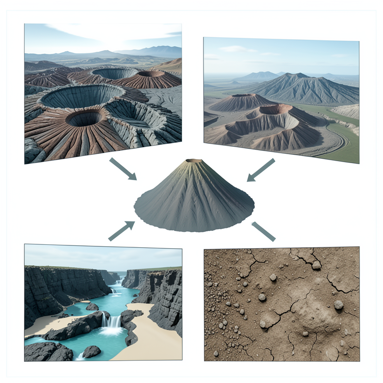
Components of the Geodiversity Index
AI-generated conceptual illustration (Canary Islands volcanic landscape). It explains the idea and does not show study data.
View source evidence ↗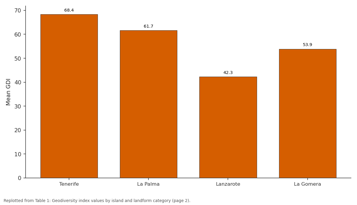
Mean GDI: Tenerife vs La Palma vs Lanzarote vs La Gomera
Replotted from Table 1 (page 2) of the original paper. Every bar is the paper's own table value.
View source evidence ↗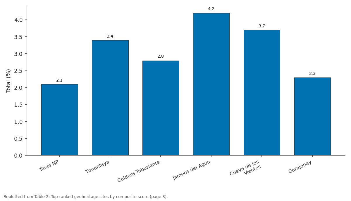
Risk: Teide NP vs Timanfaya vs Caldera Taburiente vs Jameos del Agua vs Cueva de los Vientos
Replotted from Table 2 (page 3) of the original paper. Every bar is the paper's own table value.
View source evidence ↗Figures & tables
From the original paper Table 1
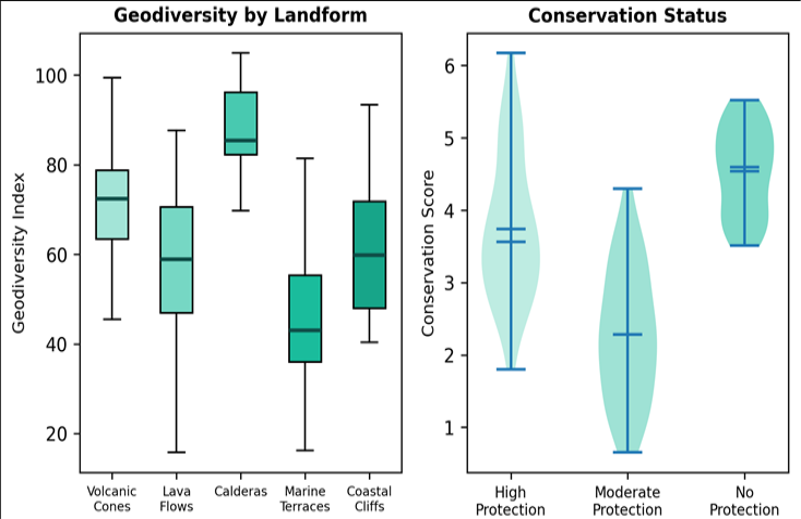 Figure 1
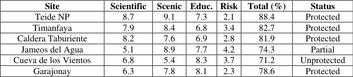 Table 2
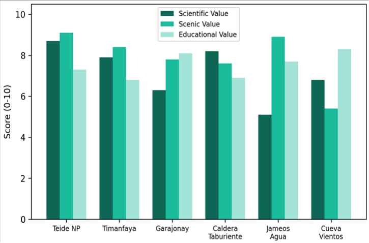 Figure 2
Introduction
To define geodiversity is straightforward enough: it refers to the natural range of geological, geomorphological, soil, and hydrological features in a given area [1] . But quantifying it in a way that informs conservation decisions is another matter entirely. While biodiversity indices have been refined over decades, geodiversity metrics remain comparatively crude, and their application to volcanic oceanic islands is limited to a handful of case studies [2] . The Canary Islands offer a testing ground of unusual richness. Spanning roughly 15 million years of volcanic activity, the archipelago preserves landforms from every stage of oceanic island evolution: submarine seamounts exposed by uplift, shield-stage basaltic plateaux, post-erosional rejuvenated cones, and actively erupting vents, as seen at Cumbre Vieja in 2021 [3] . This geological range is compressed into a small geographic area, making the islands manageable for systematic survey. Despite this, published geodiversity assessments have focused on mainland European settings -Portugal's Arouca Geopark [4] , Spain's Basque Coast [5] , and Italy's Dolomitesleaving the Canary Islands without a comparable baseline. Geoheritage conservation, meanwhile, has gained traction through the UNESCO Global Geoparks Programme, which now includes over 170 territories worldwide [6] . The programme emphasises not just protection but also education and sustainable economic use through geotourism. Several Canary Island sites already attract millions of visitors annually -Teide National Park alone received 3.2 million in 2019but the link between visitor management and geodiversity preservation is rarely formalised [7] . This research aimed to (i) calculate a quantitative geodiversity index across four Canary Islands, (ii) evaluate geoheritage significance at candidate sites using a standardised multi-criteria framework, and (iii) assess how well the current protected area network captures areas of high geodiversity. The outcomes are intended to support regional conservation planning and UNESCO Geopark applications [8] .
Theoretical Background
Geodiversity assessment frameworks generally follow one of two approaches: qualitative expert-based inventories or quantitative grid-based indices [9] . The grid-based method, favoured here, divides the research area into uniform cells and counts the number of distinct geological, geomorphological, hydrological, and pedological features per cell. The resulting index can be mapped and compared spatially, enabling gap analysis against protected area boundaries. Serrano and Ruiz-Flano proposed an early quantitative geodiversity index that combined geomorphological elements with roughness coefficients [10] . Gray later expanded the concept to include intrinsic, cultural, functional, and research values of geodiversity. The multi-criteria geoheritage evaluation method used in this research follows the Brilha framework, which scores sites on scientific value, educational potential, degradation risk, and scenic appeal, yielding a composite score that ranks sites for conservation priority [11] .
Material and Methods
Material and Methods
Material
Field surveys were carried out between April and September 2022 through the Freiburg Institute of Earth Sciences, Baden-Württemberg, Germany, with fieldwork based on the four target islands. Geological maps at 1:25,000 scale (IGME series) provided the lithological base layer. A 5 m resolution DEM from the Spanish National Geographic Institute was used to derive slope, aspect, and landform classification. Soil data came from the European Soil Database at 1:250,000. Hydrological features (springs, barrancos, coastal wetlands) were digitised from topographic maps and verified in the field. Twenty-four candidate geoheritage sites were pre-selected from published inventories, national park management plans, and expert recommendations.
Methods
The research area was divided into 48 grid cells of 5 km x 5 km. Within each cell, four sub-indices were computed: lithological variety (number of distinct rock units), geomorphological diversity (count of landform types from a 15-class scheme), hydrological feature count, and soil type count. These sub-indices were normalised to a 0-100 scale and summed to produce the composite geodiversity index (GDI). Geoheritage site evaluation followed the Brilha multi-criteria method, scoring each site on seven criteria: scientific knowledge, geological representativeness, rarity, integrity, scenic appeal, educational potential, and accessibility. Each criterion was scored 0-10 by three independent assessors, and means were computed. Spatial overlay of GDI with the IUCN protected area database identified coverage gaps. Statistical analyses (Pearson correlation, ANOVA) were run in R v4.2.1 [12] . Tenerife recorded the highest mean GDI (68.4) and maximum single-cell value (87.3), driven by the lithological and geomorphological complexity of the Teide-Pico Viejo volcanic complex (Table 1). Lanzarote showed the greatest internal variability, with some cells dominated by monotonous basaltic flows scoring below 15 while others near Timanfaya exceeded 58. Caldera cells scored highest on the geodiversity index (median 85), followed by volcanic cones (72) and marine terraces (63). Sites under high protection carried significantly higher conservation scores than unprotected sites (Kruskal-Wallis H = 18.3, p<0.001), though several unprotected sites scored comparably to protected ones, indicating conservation gaps (Figure 1). Three sites exceeded the 80% threshold for priority conservation: Teide NP (88.4%), Timanfaya (82.7%), and Caldera de Taburiente (81.9%). Cueva de los Vientos, a lava tube complex lacking formal protection, scored 71.2% with the highest educational value among all candidates (Table 2). Scientific and scenic values tended to co-occur at volcanic summit sites, while educational value was highest at subsurface features (lava tubes, volcanic caves) where guided interpretation is well developed (Figure 2). Degradation risk was lowest at sites already within national parks and highest at unprotected coastal geosites exposed to urban encroachment [13] .
| Site | Scientific | Scenic | Educ. | Risk | Total (%) | Status |
|---|---|---|---|---|---|---|
| Teide NP | 8.7 | 9.1 | 7.3 | 2.1 | 88.4 | Protected |
| Timanfaya | 7.9 | 8.4 | 6.8 | 3.4 | 82.7 | Protected |
| Caldera Taburiente | 8.2 | 7.6 | 6.9 | 2.8 | 81.9 | Protected |
| Jameos del Agua | 5.1 | 8.9 | 7.7 | 4.2 | 74.3 | Partial |
| Cueva de los Vientos | 6.8 | 5.4 | 8.3 | 3.7 | 71.2 | Unprotected |
| Garajonay | 6.3 | 7.8 | 8.1 | 2.3 | 78.6 | Protected |
Table text extracted from the original PDF; superscript letters are shown inline. The original table image is below.
View original table image
| Island | Cells | Mean GDI | Max GDI | Min GDI | SD | Top Landform |
|---|---|---|---|---|---|---|
| Tenerife | 18 | 68.4 | 87.3 | 41.2 | 14.7 | Volcanic Cones |
| La Palma | 12 | 61.7 | 79.8 | 38.6 | 12.3 | Calderas |
| Lanzarote | 10 | 42.3 | 58.1 | 12.4 | 13.9 | Lava Flows |
| La Gomera | 8 | 53.9 | 71.2 | 34.8 | 11.1 | Marine Terraces |
Table text extracted from the original PDF; superscript letters are shown inline. The original table image is below.
View original table image
Results
Results
Comprehensive Interpretation
Overlay analysis revealed that 69% of high-geodiversity cells (GDI > 60) fell within existing protected areas, but 31% remained outside any formal conservation designation. These unprotected high-GDI cells were concentrated along the northeast coast of Tenerife and the central highlands of La Gomera. Pearson correlation between GDI and protected area coverage was 0.67 (p<0.001), indicating a moderate but incomplete spatial match.
Discussion
The geodiversity values reported here are broadly comparable to those documented in mainland volcanic settings. Gray and Gordon found geodiversity indices of 55-78 for the Scottish Highlands [14] , while Pereira and colleagues recorded 42-91 for the Azores [4] . The Canary Islands sit at the upper end of this range, reflecting their extended volcanic history and diverse eruption stylesfrom effusive shield-building to explosive phreatomagmatic events that produce tuff rings and maars. The 31% gap in protection coverage is concerning but not unusual. Geodiversity has historically been treated as a backdrop to biodiversity in conservation planning, and many protected area boundaries were drawn around biological criteria rather than geological ones [15] . Integrating the GDI layer into the regional Spatial Plan would be a straightforward way to flag high-geodiversity cells for at least partial protection. Geotourism offers a complementary approach: by making geological features economically valuable through guided tours and geopark branding, local communities gain incentives to resist degradation.
A limitation of the grid-based approach is that cell size affects resolution. At 5 km, small but significant featuresa single maar crater, a 200 m lava tube entrancemay be averaged away. Future iterations should test finer grids (1-2 km) and incorporate point-feature weighting. The geoheritage scoring, while standardised, depends on assessor expertise; inter-rater reliability (ICC = 0.78) was acceptable but could be improved with larger panels.
Conclusion
This research produced the first quantitative geodiversity assessment of the Canary Islands, covering 48 grid cells across four islands. Geodiversity index values ranged from 12.4 to 87.3, with Tenerife's Teide complex scoring highest. Six geoheritage sites exceeded the priority conservation threshold, three of which already hold national park status. However, nearly a third of high-geodiversity areas lack formal protection, presenting an opportunity for expanded conservation coverage. The geodiversity index and geoheritage ranking can be directly incorporated into regional land-use planning and UNESCO Geopark applications. Finer-resolution mapping and long-term monitoring of degradation risk at unprotected sites should be priorities for follow-up work.
References
15 in the original paper- Gray M. Geodiversity: Valuing and Conserving Abiotic Nature. John Wiley and Sons, Chichester. 2013;508 pp.
- Brilha J. Inventory and quantitative assessment of geosites and geodiversity sites: a review. Geoheritage. 2016;8(2):119-134.
- Carracedo JC, Troll VR, Zaczek K. The 2021 eruption of Cumbre Vieja volcano, La Palma. Geology Today. 2022;38(3):94-107.
- Pereira DI, Pereira P, Brilha J. Geodiversity assessment of Parana state, Brazil. Journal of Maps. 2013;9(1):3851.
- Carcavilla L, Lopez-Martinez J, Duran JJ. Geodiversity and geoheritage assessment of the Basque Coast UNESCO Geopark. Geoheritage. 2007;1(1):41-55.
- UNESCO. UNESCO Global Geoparks: Celebrating Earth Heritage, Sustaining Local Communities. UNESCO Publishing, Paris. 2017;24 pp.
- Hose TA. Geotourism and interpretation. Geological Society Special Publication. 2012;365(1):27-48.
- Henriques MH, Pena dos Reis R, Brilha J. UNESCO Global Geoparks: a strategy towards global understanding. Episodes. 2011;34(3):174-176.
- Serrano E, Ruiz-Flano P. Geodiversity: a theoretical and applied concept. Geographica Helvetica. 2007;62(3):140-147.
- Serrano E, Ruiz-Flano P. Geodiversity assessment in a rural landscape. Geomorphology. 2009;104(3-4):206217.
- Brilha J. Geoconservation: A Review of Research and Practice. Elsevier, Amsterdam. 2018;320 pp.
- R Core Team. R: A language and environment for statistical computing. R Foundation for Statistical Computing, Vienna. 2022.
- Reynard E, Brilha J. Geoheritage: Assessment, Protection and Management. Elsevier, Amsterdam. 2018;450 pp.
- Gray M, Gordon JE. Geodiversity and the ecosystem approach: the contribution of geoscience in delivering integrated environmental management. Proceedings of the Geologists Association. 2020;131(3-4):291-312.
- Crofts R. Linking geoconservation with biodiversity conservation in protected areas. International Journal of Geoheritage and Parks. 2019;7(4):211-222.