
Research article · 2026 · Full text
International Journal of Geography Geology and EnvironmentGeoAI-Supported Early Warning Systems for Extreme Weather Events and their Implications in India
Volume 8(4) · Pages 16–27 · DOI: 10.22271/27067483.2026.v8.i4a.505 ↗
Research areasEnergy and Environmental SystemsFlood Risk Assessment and ManagementHydrological Forecasting Using AI
Abstract
Author-writtenExtreme weather events — cyclones, flash floods, heat waves, cloudbursts, and droughts — are intensifying across India in both frequency and magnitude under the influence of accelerating climate change. Timely and spatially precise early warning systems (EWS) are therefore indispensable for safeguarding lives and livelihoods. The convergence of Geospatial Artificial Intelligence (GeoAI) — encompassing machine learning (ML), deep learning (DL), remote sensing, and Geographic Information Systems (GIS) — is transforming how such warnings are generated, disseminated, and acted upon. This systematic review examines GeoAI-enabled EWS architectures applicable to India's diverse hydro-meteorological and socio-geographic landscape, synthesising 218 peer-reviewed publications, 34 technical reports, and 12 government policy documents published between 2015 and 2024. Key performance findings include: augmenting physics-based flood models with Long Short-Term Memory (LSTM) networks reduces forecasting root mean square error (RMSE) by 15–30% in the Ganga and Brahmaputra basins; ensemble machine learning achieves landslide susceptibility classification accuracy (AUC) of 0.88–0.93 across the Himalayan arc; and attention-based convolutional networks approach AUC 0.77–0.81 for rapid cyclone intensification prediction. The review traces theoretical foundations, technological components, case applications across Indian states, institutional frameworks, data challenges, ethical dimensions, and emerging research frontiers. It critically examines the gap between technological capability and on-the-ground implementation, with particular attention to last-mile connectivity, community vulnerability, and governance. The paper concludes with a forward-looking research agenda and policy recommendations tailored to India's federal disaster risk management architecture.
Summary
Source-checkedPlain-language reading of the full paper, prepared with AI and checked against the text. Each point links to the authors' own words.
Why it matters
- Climate change is increasing the frequency and magnitude of extreme weather events in India, including cyclones, droughts, and flash floods. View evidence ↗
- India faces extreme hydro-meteorological risks, contributing to about 8% of global economic losses from natural disasters, with floods, cyclones, droughts, and landslides causing over 75% of disaster fatalities. View evidence ↗
- A critical gap exists in India's disaster management where advanced atmospheric modeling is hindered by outdated warning dissemination infrastructure. View evidence ↗
The question
- The review aims to examine how Geospatial Artificial Intelligence (GeoAI) technologies can be integrated into early warning systems within India's specific climatic and institutional environment. View evidence ↗
What they did
- The authors conducted a systematic literature search from January to October 2024 across academic databases and Indian government institutional repositories. View evidence ↗
What they found
- In the Ganga and Brahmaputra basins, adding Long Short-Term Memory (LSTM) networks to physics-based models reduced the root mean square error (RMSE) of peak discharge forecasts by 15–30%. View evidence ↗
- Ensemble machine learning models using XGBoost and Random Forest achieved an Area Under the Curve (AUC) of 0.88–0.93 for classifying landslide susceptibility in Himachal Pradesh and Uttarakhand. View evidence ↗
- Convolutional neural networks applied to satellite imagery improved 24-hour rapid intensification (RI) probability forecasts for cyclones, achieving AUC scores of 0.77–0.81. View evidence ↗
- Random forest regression fusing multiple satellite and rainfall datasets improved drought monitoring by providing district-level severity estimates every 8 days, compared to previous monthly products. View evidence ↗
- LSTM-based models can predict maximum temperature anomalies for heat waves 5–7 days in advance with a root mean square error (RMSE) of less than one degree. View evidence ↗
- A hybrid pipeline for the Mahanadi basin extended the skillful warning lead time for floods from 24 to 72 hours, meeting the 48–60 hour requirement for effective community evacuation. View evidence ↗
What it means
- The authors conclude that while the technical tools for GeoAI-EWS exist, the primary challenge is building an institutional trust architecture to ensure warnings lead to actual protective action. View evidence ↗
- The authors recommend establishing a National GeoAI-EWS Integration Programme under the Ministry of Earth Sciences to coordinate the operationalization of AI-enhanced warnings. View evidence ↗
- The review is limited by its reliance on English-language databases, which may have excluded relevant research published in regional Indian languages or non-indexed government reports. View evidence ↗
- The evidence base is asymmetrical, with flood and cyclone systems being more extensively studied and represented than heat wave and drought warning systems. View evidence ↗
Visual summary
1 visualsIllustrations explain the paper; they do not show study data.
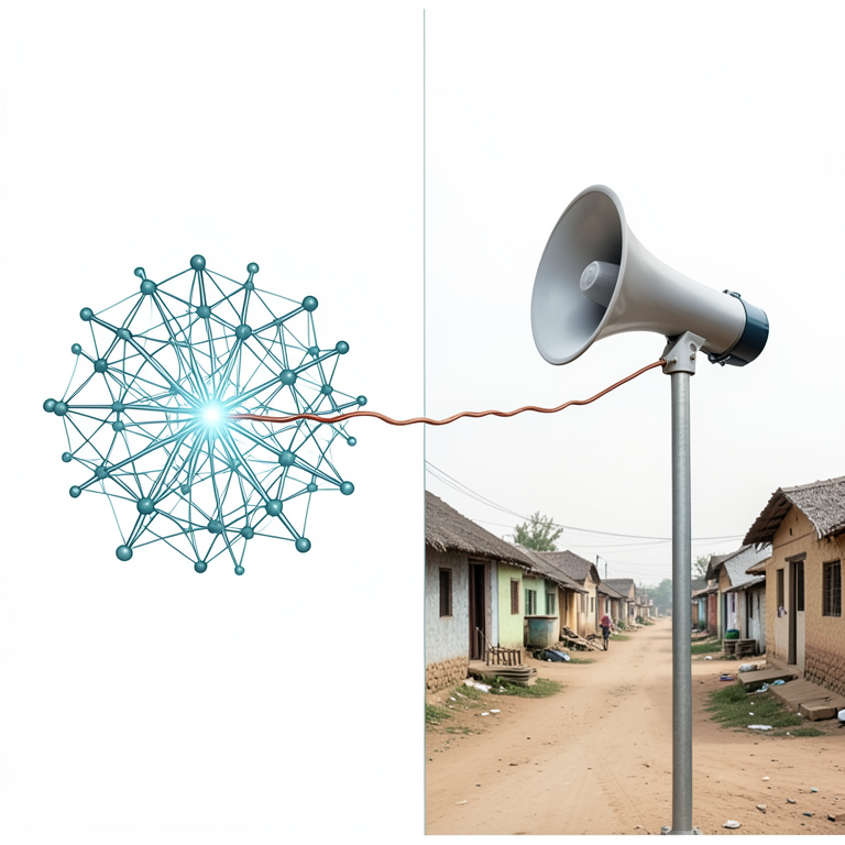
The EWS Gap
AI-generated conceptual illustration (A rural Indian village with a loudspeaker pole and a digital neural network visualization). It explains the idea and does not show study data.
View source evidence ↗Figures & tables
From the original paper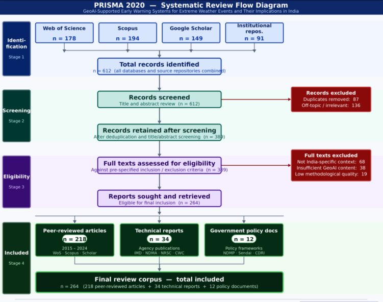 Figure 1
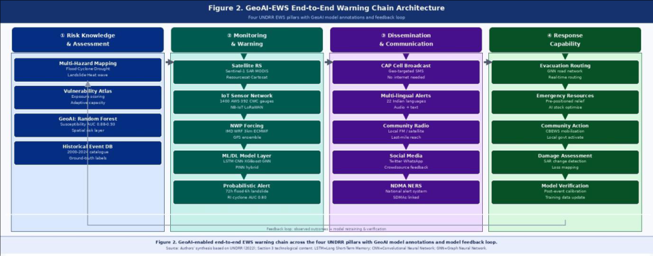 Figure 2
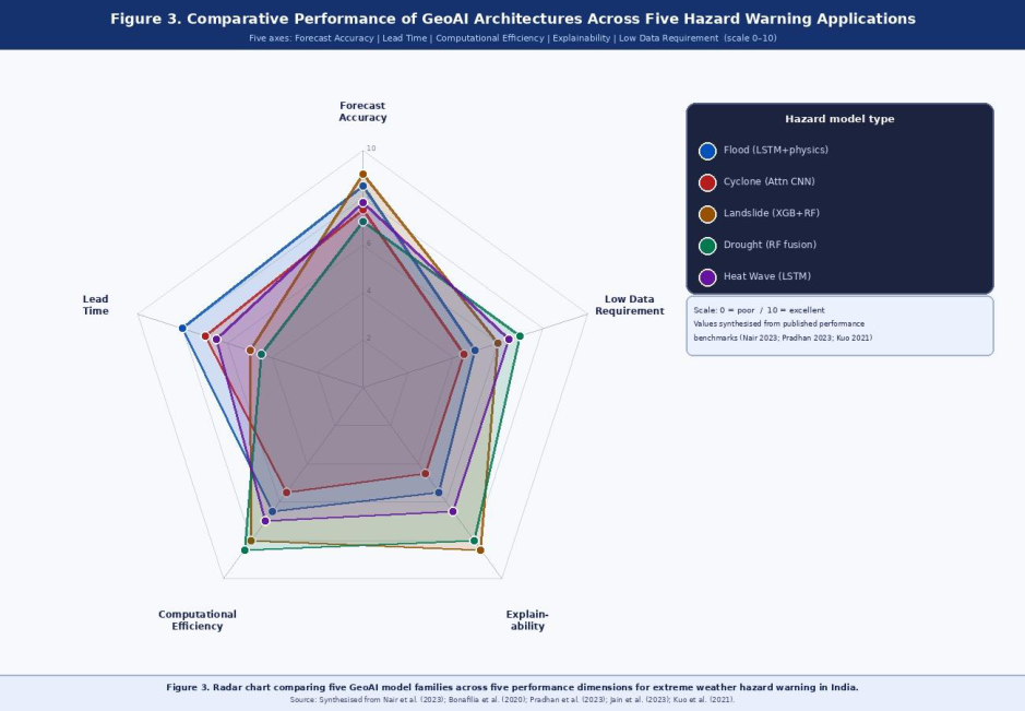 Figure 3
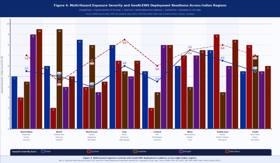 Figure 4
 Table 1
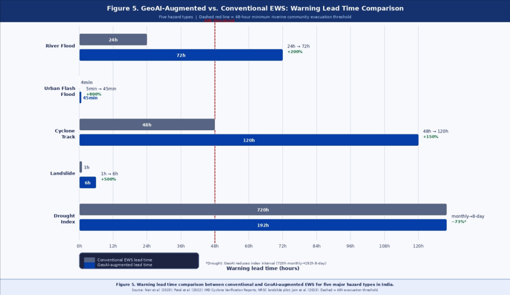 Figure 5
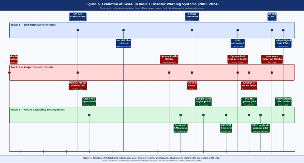 Figure 6
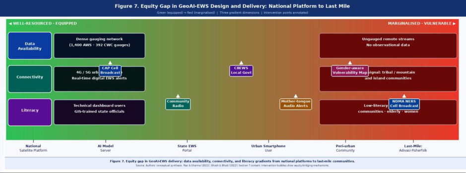 Figure 7
Introduction 1.1 Context and Motivation
When Cyclone Amphan made landfall over West Bengal in May 2020, its 185 km/h sustained winds and catastrophic storm surge had been forecast with near-perfect track accuracy three days in advancea feat unimaginable a decade earlier. Yet for all that technological achievement, the warning reached millions of coastal residents through the same broadcast radio and loudspeaker systems that had served since the 1970s. Amphan killed 128 people and caused damages exceeding ₹1 lakh crore. This juxtapositionworldclass atmospheric modelling paired with last-century dissemination infrastructureencapsulates the central challenge this review addresses. India's exposure to hydro-meteorological hazards is extraordinary by any measure. The country accounts for approximately 8% of global economic losses from natural disasters (World Bank, 2021), while floods, cyclones, droughts, and landslides together claim more than 75% of disaster-related fatalities, affecting millions annually (NDMA, 2022). The Bay of Bengal cyclone basin, the Himalayan cryosphere, the Ganga-Brahmaputra floodplain, the arid Thar Desert, and the semi-arid Deccan Plateau each present distinct but interrelated hazard profiles that demand spatially differentiated warning mechanisms. The traditional paradigm of disaster warningdominated by statistical meteorology, threshold-based alerts, and broadcast radio disseminationis increasingly inadequate in the face of non-linear climate signals, rapid urbanisation, and the explosive growth of at-risk populations in coastal and riverine corridors. A new generation of Geospatial Artificial Intelligence (GeoAI) tools offers a genuine opportunity to move from reactive to anticipatory disaster governance. By fusing heterogeneous geospatial data streams with advanced computational intelligence, GeoAI enables hazard probability modelling at granular spatial and temporal scales previously unattainable through conventional methods.
Scope and Objectives
This review focuses on the intersection of GeoAI technologies and early warning system development within the Indian geophysical, climatic, and institutional context. Five objectives guide the review: To synthesise the theoretical and technological foundations of GeoAI-enabled EWS; To map documented GeoAI applications for flood, cyclone, drought, heat wave, and landslide warning in India; To evaluate institutional, data, and infrastructure challenges impeding operationalisation; To assess ethical and social justice dimensions of AIdriven warning systems; and To propose a forward-looking research and policy agenda.
Review Methodology
A systematic literature search was conducted across Web of Science, Scopus, Google Scholar, and institutional repositories of the India Meteorological Department (IMD), National Remote Sensing Centre (NRSC), and NITI Aayog between January and October 2024. Search strings combined terms including "GeoAI,""geospatial artificial intelligence,""machine learning disaster,""deep learning weather prediction,""remote sensing flood," and "early warning India," and their Boolean combinations. Articles were screened using PRISMA-aligned criteria (Page et al., 2021); a total of 218 peer-reviewed publications, 34 technical reports, and 12 government policy documents were included after deduplication and quality filtering.
Theoretical Foundations 2.1 Defining GeoAI
Geospatial Artificial Intelligence (GeoAI) is broadly defined as the integration of artificial intelligencemachine learning, deep learning, natural language processing, and computer visionwith geospatial data science to analyse spatial phenomena at scale (Li & Hsu, 2022). Unlike conventional geostatistics, which assumes stationarity and relies on parametric models, GeoAI exploits the representational power of neural networks and ensemble learners to capture complex, non-linear spatial dependencies in multi-source, high-dimensional datasets. What distinguishes GeoAI from conventional GIS is not the component partsmost have existed for decadesbut Rasterio, and PyTorch Geometric.
Early Warning Systems: Conceptual Architecture
The United Nations Office for Disaster Risk Reduction (UNDRR) defines a people-centred EWS as comprising four interlinked elements: (1) risk knowledge and assessment, (2) monitoring and warning services, (3) dissemination and communication, and (4) response capability (UNDRR, 2022). Effective EWS require that information flows seamlessly across these elementsfrom hazard observation through modelling and alert generation to community-level responsewithout critical breaks in the chain. GeoAI has the potential to enhance each element, but its greatest impact lies in transforming monitoring data into actionable, probabilistic, spatially explicit warning products. Two fundamental paradigms govern EWS modelling: (a) physics-based or process-based models that simulate the physical laws governing atmospheric, hydrological, or geomorphological systems, and (b) data-driven models that learn predictive relationships empirically from historical observations. Modern EWS increasingly employ hybrid approaches that embed physical constraints into data-driven architecturesso-called physics-informed machine learning (PIML)to ensure physically consistent outputs even in data-sparse regions. Himawari-8/9 geostationary series, provide multi-spectral, SAR, and thermal imagery at temporal resolutions ranging from 10minute geostationary cycles to 3-5-day polar-orbit revisits (ISRO, 2023). Sentinel-1 C-band SAR is particularly valuable for flood mapping under cloud covera significant advantage during monsoon season when optical sensors are largely obscured. The launch of ISRO's EOS series and the planned NovaSAR cooperation underscore India's expanding domestic satellite capacity. Google Earth Engine (GEE) has democratised access to petabyte-scale satellite archives, enabling nearreal-time geospatial analysis without requiring local computing infrastructurea critical enabler for resourceconstrained state disaster management agencies.
Ground-Based Sensor Networks and IoT
Dense networks of automated weather stations (AWS), river gauge sensors, soil moisture probes, rain gauges, and ocean buoys provide ground-truth data that satellite platforms alone cannot supply. The IMD operates approximately 1,400 AWS across India as of 2024, supplemented by the Central Water Commission's (CWC) 392 flood forecasting stations on major river basins (CWC, 2023, p. 47). The Internet of Things (IoT) paradigm is extending this network to peri-urban and rural areas through low-cost, solarpowered sensors connected via LoRaWAN, NB-IoT, and 4G/5G protocols, enabling near-real-time hydrological monitoring at sub-basin scales.
Numerical Weather Prediction Models
Numerical Weather Prediction (NWP) modelsnotably the Weather Research and Forecasting (WRF) model run operationally by IMD and regional centres, the Global Forecast System (GFS), and the European Centre for Medium-Range Weather Forecasts (ECMWF) ensembleprovide gridded atmospheric forecasts that serve as primary inputs for downstream hazard models. IMD's highresolution WRF configurations at 12 km and 3 km grid spacing, and the newly operationalised Unified Model (UM) in partnership with the UK Met Office (IMD, 2023), represent the current state of the art for South Asian mesoscale weather prediction.
Machine Learning and Deep Learning Architectures 3.2.1 Supervised Learning for Hazard Classification
Supervised ML algorithmsrandom forests (RF), gradient boosting machines (GBM), support vector machines (SVM), and logistic regressionhave been extensively applied to binary and multi-class hazard susceptibility mapping. Random forests are particularly well-suited to geospatial classification tasks owing to their robustness to multicollinearity among predictor variables and their native capacity to estimate feature importance, facilitating interpretability (Arabameri et al., 2020). In the Indian context, RF models have demonstrated classification accuracies exceeding 85% for flood inundation delineation in the Brahmaputra and Mahanadi basins
Deep Learning for Spatiotemporal Pattern Recognition
Convolutional Neural Networks (CNNs) excel at extracting spatial features from raster imagery, making them the architecture of choice for satellite-based flood and landslide detection. U-Net and its variants -ResUNet, Swin-UNet have achieved state-of-the-art performance in binary semantic segmentation of flooded versus non-flooded pixels in SAR imagery, achieving intersection-over-union (IoU) scores of 0.65-0.87 across diverse geographies in benchmark evaluations (Bonafilia et al., 2020). Long Short-Term Memory (LSTM) networks and Gated Recurrent Units (GRUs) capture temporal dependencies in sequential hydrometeorological datarainfall time series, stream gauge recordsenabling multi-step-ahead flood stage forecasting with lead times up to 72 hours. Transformer-based architectures, originally developed for natural language processing, are increasingly applied to spatiotemporal weather prediction. Google's GraphCast and Huawei's Pangu-Weather models have demonstrated forecast skill comparable to or exceeding ECMWF's ensemble mean at 10-day horizons at a fraction of the computational cost (Lam et al., 2023). These global AI weather models are beginning to be fine-tuned on India-specific regional datasets, opening a new frontier for sub-seasonal warning.
Graph Neural Networks and Spatial Reasoning
Graph Neural Networks (GNNs) offer a natural framework for modelling spatially irregular networksriver channel networks, road networks used for evacuation routing, and community social networks governing warning dissemination. By representing spatial entities as nodes and their relationships as edges, GNNs can propagate flood wave information along hydrographic networks or simulate disease spread following disaster events, enabling integrated risk assessment beyond purely meteorological concerns.
Explainable AI (XAI) in EWS
A persistent challenge in deploying ML models for EWS is the "black-box" problem: high-performing neural networks offer limited human-interpretable explanations of their predictions, which undermines trust among emergency managers, meteorologists, and affected communities. Explainable AI (XAI) methodsincluding SHapley Additive exPlanations (SHAP), Local Interpretable Model-Agnostic Explanations (LIME), and attention visualisation in transformer modelsprovide post-hoc or intrinsic interpretability by attributing model outputs to individual input features (Arrieta et al., 2020). SHAP analysis has revealed, for instance, that antecedent soil moisture consistently ranks among the top three predictors of flash flood occurrence in the Western Ghatsa finding that aligns with hydrological process knowledge and can guide field data collection priorities. Embedding XAI into operational GeoAI-EWS platforms is therefore not merely a technical refinement but a governance imperative, particularly in contexts where warnings carry legal and financial consequences.
Digital Twins and Simulation Environments
The concept of a geospatial digital twina high-fidelity, continuously updated virtual replica of a physical territory represents the next frontier of GeoAI-enabled EWS. For urban flood management, a city-scale digital twin integrates real-time sensor feeds, 3D building models, drainage network topology, and DEM-derived hydraulic simulations to produce dynamic inundation forecasts at the neighbourhood level. Pilots in Chennai, Pune, and Ahmedabad under the National Urban Digital Mission (NUDM) are beginning to explore these architectures (MoHUA, 2023). Each polygon represents a hazard-specific model family.
GeoAI Applications for Extreme Weather Early Warning in India
The five hazard categories examined below represent the most socioeconomically consequential extreme weather threats across India's diverse regional geographies. For each, we document the state of current GeoAI deployment, the evidence base for performance improvement, and the specific data and modelling challenges that remain unresolved.
Heat Wave Warning Systems
Heat waves represent a rapidly growing mortality risk in India. The 2015 heat wave claimed approximately 2,500 lives across Andhra Pradesh and Telangana, and the frequency of extreme heat events is projected to increase threefold by 2050 under medium warming scenarios (IPCC, 2021). IMD operationalises heat wave warnings using threshold criteria (maximum temperature ≥ 40°C in plains and ≥ 30°C in hilly regions, with specific anomaly thresholds), but these are determined at district level and do not capture intra-urban heat exposure heterogeneity. GeoAI approaches are transforming heat wave risk communication by enabling Urban Heat Island (UHI) mapping at building-block resolution through fusion of Landsat-8/9 thermal infrared data, high-resolution OpenStreetMap building footprints, vegetation indices, and albedo datasets. LSTM-based models trained on ERA5 reanalysis and IMD station data can forecast maximum temperature anomalies 5-7 days ahead with sub-degree RMSE, enabling proactive public health advisories and cooling centre activation by urban local bodies.
Data Challenges and Infrastructure Gaps 5.1 Data Availability and Quality
Robust GeoAI models require large volumes of highquality, labelled training data. For rare extreme events, the historical record may contain only a few dozen welldocumented occurrences, making supervised learning inherently challenging. This problem is acute for severe landslide events in remote Himalayan terrain, where systematic inventory data are sparse and unevenly distributed across geological provinces. Transfer learningpre-training models on global or regional datasets and finetuning on India-specific datapartially mitigates this
Inter-Agency Coordination Challenges
The multiplicity of agencies involved in EWSeach with distinct data protocols, communication systems, and organisational culturescreates coordination costs that can delay warning dissemination during fast-onset events. The Integrated Flood Warning System (IFLOWS-Mumbai), developed jointly by IMD, the Brihanmumbai Municipal Corporation (BMC), NDMA, and NRSC following the 2005 floods (BMC/NDMA, 2020), represents one of the few genuinely multi-agency, GeoAI-augmented operational flood warning systems in India and provides a replicable governance model for other metropolitan centres.
International Collaborations
India participates in several multilateral frameworks that enhance GeoAI-EWS capabilities. The SERVIR programme, a joint initiative of NASA and USAID with regional hubs in Asia, supports the integration of satellitebased geospatial tools into national EWS operations. The WMO's Global Multi-Hazard Alert System (GMAS), to which IMD contributes as a Regional Specialised Meteorological Centre, is progressively incorporating AIbased warning products and operates through the Common Alerting Protocol (CAP) standard, enabling machinereadable alerts to be automatically relayed across national warning platforms. Bilateral collaborations with the European Space Agency (ESA), the Japanese Meteorological Agency (JMA), and the UK Met Office further augment India's warning science capacity.
Algorithmic Bias and Model Fairness
Training data for GeoAI models typically reflects the geographic and socioeconomic biases embedded in historical observation networks. Flood models trained predominantly on gauged river basins in northern India may underperform in the ungauged streams of Northeast India or peninsular river systems with distinct hydrological regimes. Similarly, land use classifications derived from highresolution urban imagery may systematically misclassify informal settlements and peri-urban areas with complex land cover mosaics, producing spatially biased inundation predictions (Ghosh & Bhatt, 2022). Fairness-aware machine learningthrough stratified sampling, re-weighting of loss functions, or adversarial debiasingcan partially mitigate these effects. Addressing the root cause requires sustained investment in equitable observational infrastructure and inclusive data collection practices that are not yet systematically incorporated into India's EWS development programmes.
Warning Uncertainty Communication
Probabilistic AI-based warningswhich naturally produce uncertainty ranges rather than single deterministic forecasts require careful communication to avoid misinterpretation. Overconfident warnings that fail to materialise erode community trust; underconfident warnings that hedge excessively fail to motivate protective action. Research in risk communication consistently finds that visualisation of uncertainty through probability maps, confidence intervals, and scenario-based narrativestailored to the literacy levels and cultural contexts of target audiencessignificantly improves warning uptake compared to technical jargon-heavy text alerts (Morss et al., 2020).
Inclusive EWS Design Standards
NDMA should develop and enforce national inclusive EWS design standards requiring that all operational GeoAI-EWS include: (a) multi-lingual warning products in regional languages, (b) audio-based alert formats for low-literacy populations, (c) gender-disaggregated vulnerability overlays in spatial warning products, and (d) community feedback loops for continuously improving warning relevance and uptake. These standards should be grounded in participatory co-design processes that genuinely engage frontline communities in system design, not merely in consultation.
Limitations
Several limitations of this review warrant acknowledgement. First, the literature search, while systematic, was conducted in English-language databases and may underrepresent significant grey literature and research published in Indian regional languages or in government technical reports not indexed in Scopus or Web of Science. Second, the review encompasses a rapidly evolving field; GeoAI model architectures and performance benchmarks documented here reflect the state of the literature up to October 2024 and will be superseded by subsequent developments. Third, performance figures cited for specific ML models reflect results from their original study contexts, which may differ substantially from operational conditions in terms of data quality, computing infrastructure, and institutional readiness. Readers should interpret reported accuracy metrics as indicative benchmarks rather than guaranteed operational performance. Fourth, the coverage of different hazard types is not entirely symmetrical: flood and cyclone EWS have been more extensively studied in the Indian context and are consequently better represented in the evidence base than heat wave and drought warning systems, which remain comparatively underdeveloped in the GeoAI literature.
Finally, the policy recommendations proposed in Section 9 are grounded in the evidence reviewed but should be validated through consultation with operational practitioners and policymakers before formal adoption.
Conclusion
GeoAI marks a genuine inflection point in India's capacity to develop and operationalise early warning systems for extreme weather events. The convergence of satellite remote sensing, deep learning, cloud computing, and real-time sensor networks creates an opportunity to extend warning lead times, sharpen spatial precision, and personalise risk communication across India's extraordinarily diverse hydrometeorological and socio-geographic landscape. This review has documented the growing evidence base for GeoAI-EWS across five major hazard categoriesfloods, cyclones, landslides, droughts, and heat waveswhile honestly confronting the data, infrastructure, institutional, and equity challenges that separate technological potential from operational reality. The performance improvements are real and significant: LSTM augmentation reduces flood forecasting RMSE by 15-30%; ensemble ML achieves landslide susceptibility classification at AUC 0.88-0.93; and AI-based cyclone intensity tools are beginning to close the most consequential remaining gap in tropical warning science. Yet performance metrics are not the ultimate measure of an EWS. The architecture of trustbetween AI systems and their operators, between warning agencies and communities, between national institutions and last-mile respondersmust be constructed with the same rigour and investment as the algorithms themselves. GeoAI systems that are accurate but opaque, precise but inaccessible, or innovative but inequitable will fail at the question that ultimately matters: whether vulnerable people receive, understand, and act upon warnings in time to protect their lives. India is, in many respects, the most consequential testing ground for GeoAI-enabled warning science on earth. The complexity of its hazard geography, the scale of its at-risk population, the diversity of its institutional arrangements, and the maturity of its scientific establishment make every lesson learned here applicable across a significant fraction of global disaster vulnerability. The path forward is not primarily technicalthe algorithms exist, the satellite data streams are available, and the computational infrastructure is being built. What remains to be constructed, with the same deliberateness and investment that built IMD's supercomputing capacity or ISRO's earth observation fleet, is the institutional trust architecture that allows a probabilistic AI-generated warning to motivate protective action in a flood-prone household in Assam or a heatvulnerable worker in a Rajasthan city. That construction projectspanning data governance reform, community codesign, equity-conscious engineering, and sustained political commitmentis where the work of the next decade must begin.
Figures and tables from the paper
| Hazard Type | Primary GeoAI Method | Key Performance Gain | Warning Lead Time | Principal Gap |
|---|---|---|---|---|
| River Flood | LSTM + physics hybrid | RMSE ↓15–30% vs. physics-only (Nair et al., 2023) | 24 h → 72 h | Ungauged basins |
| Urban Flash Flood | CNN + QPE + crowdsource | Ward-level 30–60 min warnings (Patel et al., 2022) | 30–60 min | Drainage data quality |
| Cyclone Intensity | Attention CNN on IR satellite | AUC 0.77–0.81 for RI (Kuo et al., 2021) | 24–48 h | Rapid intensification |
| Landslide | XGBoost + RF ensemble | AUC 0.88–0.93 susceptibility (Pradhan et al., 2023) | 6 h | Sparse inventory data |
| Drought | RF multi-index fusion | 8-day vs. monthly SPEI (Jain et al., 2023) | Seasonal | Crop-specific calibration |
| Heat Wave | LSTM + UHI thermal fusion | Sub-degree RMSE, 5–7 day forecast | 5–7 days | Intra-urban resolution |
Table text extracted from the original PDF; superscript letters are shown inline. The original table image is below.
View original table image
References
28 in the original paper- Arabameri A, Chandra Pal S, Rezaie F, Chakrabortty R, Saha A, Blaschke T, et al. Novel ensemble approaches of machine learning methods in predicting gully erosion susceptibility. Remote Sensing. 2020;12(11):1890. https://doi.org/10.3390/rs12111890.
- Arrieta AB, Díaz-Rodríguez N, Del Ser J, Bennetot A, Tabik S, Barbado A, et al. Explainable Artificial Intelligence (XAI): Concepts, taxonomies, opportunities and challenges toward responsible AI. Information Fusion. 2020;58:82-115. https://doi.org/10.1016/j.inffus.2019.12.012.
- Bihlo A, Popovych RO. Physics-informed neural networks for the shallow-water equations on the sphere. J Comput Phys. 2022;456:111024. https://doi.org/10.1016/j.jcp.2022.111024.
- BMC/NDMA. Integrated Flood Warning System for Mumbai (IFLOWS-Mumbai): Technical documentation. National Disaster Management Authority, Government of India; 2020.
- Bonafilia D, Tellman B, Anderson T, Issenberg E. Sen1Floods11: A georeferenced dataset to train and test deep learning flood algorithms for Sentinel-1. In: Proceedings of the IEEE/CVF Conference on Computer Vision and Pattern Recognition Workshops (CVPRW 2020). 2020. p. 210-211. https://doi.org/10.1109/CVPRW50498.2020.00113.
- Central Water Commission (CWC). Annual report on flood management and flood forecasting 2022-2023. Ministry of Jal Shakti, Government of India; 2023. https://cwc.gov.in.
- Geological Survey of India (GSI). National landslide susceptibility mapping: Phase I report. GSI Technical Report Series. 2021. https://www.gsi.gov.in.
- Ghosh T, Bhatt CM. Bias in satellite-derived flood inundation models: Evidence from informal settlements in South Asian cities. Int J Disaster Risk Sci. 2022;13(4):612-627. https://doi.org/10.1007/s13753022-00421-4.
- India Meteorological Department (IMD). Extremely severe cyclonic storm 'Fani': A report. India Meteorological Department; 2019. https://mausam.imd.gov.in.
- India Meteorological Department (IMD). Unified Model implementation for South Asia weather prediction: Technical note. Ministry of Earth Sciences, Government of India; 2023.
- Indian Space Research Organisation (ISRO). Earth observation applications for disaster management: Annual compendium. National Remote Sensing Centre (NRSC); 2023. https://www.nrsc.gov.in.
- IPCC. Climate change 2021: The physical science basis. Contribution of Working Group I to the Sixth Assessment Report of the Intergovernmental Panel on Climate Change (V. Masson-Delmotte et al., Eds.). Cambridge University Press; 2021. https://doi.org/10.1017/9781009157896.
- Jain VK, Pandey RP, Jain MK. Satellite-based multiindex agricultural drought monitoring over India using machine learning fusion. Agric Water Manag. 2023;275:107983. https://doi.org/10.1016/j.agwat.2022.107983.
- Jakubik J, Muszynski M, Vega C, Gomes DV, Fraccaro P, Oliveira Borges D, et al. Foundation models for generalist geospatial artificial intelligence. arXiv preprint arXiv:2310.18660. 2023. https://arxiv.org/abs/2310.18660.
- Kuo HC, Su SH, Kuo YH, Lin YL. Predicting rapid intensification of tropical cyclones using deep learning with multi-channel infrared satellite imagery. Geophys Res Lett. 2021;48(12):e2021GL093760. https://doi.org/10.1029/2021GL093760.
- Lam R, Sanchez-Gonzalez A, Willson M, Wirnsberger P, Fortunato M, Alet F, et al. Learning skillful mediumrange global weather forecasting. Science. 2023;382(6677):1416-1421. https://doi.org/10.1126/science.adi2336.
- Li W, Hsu CY. GeoAI: Where machine learning and big data converge in GIScience. J Spatial Inf Sci. 2022;24:71-77. https://doi.org/10.5311/JOSIS.2022.24.215.
- Ministry of Housing and Urban Affairs (MoHUA). National Urban Digital Mission: Progress report 202223. Government of India; 2023. https://mohua.gov.in.
- Morss RE, Cuite CL, Demuth JL, Hallman WK, Shwom RL. Is storm surge scary? The influence of hazard, impact, and message on perceived risk and willingness to evacuate. Int J Disaster Risk Reduc. 2020;30:49-58. https://doi.org/10.1016/j.ijdrr.2018.03.015.
- Nair A, Indu J, Rakesh V. Augmenting physics-based flood models with LSTM for improved discharge forecasting in the Brahmaputra basin. J Hydrol: Regional Stud. 2023;47:101394. https://doi.org/10.1016/j.ejrh.2023.101394.
- National Disaster Management Authority (NDMA). Annual report 2021-2022. Government of India; 2022. https://ndma.gov.in.
- Page MJ, McKenzie JE, Bossuyt PM, Boutron I, Hoffmann TC, Mulrow CD, et al. The PRISMA 2020 statement: An updated guideline for reporting systematic reviews. BMJ. 2021;372:n71. https://doi.org/10.1136/bmj.n71.
- Patel K, Shah D, Bhopal T. Real-time urban flood warning using crowdsourced social media data and radar QPE: A case study of Mumbai and Hyderabad. Urban Water J. 2022;19(5):501-516. https://doi.org/10.1080/1573062X.2022.2041781.
- Pradhan B, Nguyen VT, Nampak H, Jebur MN. Hybrid ensemble machine learning for landslide susceptibility mapping in the Himalayan Arc, India: Integration of XGBoost, random forest and topographic wetness index. Catena. 2023;220:106686. https://doi.org/10.1016/j.catena.2022.106686.
- Price I, Sanchez-Gonzalez A, Alet F, Ewalds T, ElKadi A, Stott J, et al. GenCast: Diffusion-based ensemble weather forecasting for medium range. Nature. 2024;637:84-90. https://doi.org/10.1038/s41586-024-08252-9.
- Rao N, Sharma A. Gender, caste and disaster vulnerability in rural India: Evidence from multi-state household surveys. World Dev. 2021;137:105175. https://doi.org/10.1016/j.worlddev.2020.105175.
- United Nations Office for Disaster Risk Reduction (UNDRR). Global status of multi-hazard early warning systems 2022. UNDRR; 2022. https://www.undrr.org/publication/global-status-multihazard-early-warning-systems-2022.
- World Bank. Disaster risk profile: India. World Bank Group; 2021. https://www.worldbank.org.
Social and Ethical Dimensions 7.1 Equity and the Last Mile
GeoAI-enhanced EWS risk reproducing and amplifying preexisting inequities if their design privileges data-rich, wellconnected urban populations while neglecting marginalised rural, tribal, and coastal communities. The efficacy of any EWS ultimately depends not on the sophistication of the upstream AI model but on whether the warning reaches the most vulnerable person in time for them to act. Dalits, Adivasi communities, migrant labourers, fisherfolk, and women-headed households consistently face greater exposure, higher sensitivity, and lower adaptive capacity relative to extreme weather events, yet remain systematically underrepresented in participatory EWS design processes (Rao & Sharma, 2021). Community-Based Early Warning Systems (CBEWS), which integrate local ecological knowledge with AIgenerated guidance, offer a socially inclusive complement to technically sophisticated national-scale platforms. The Kerala Sustainable Development Goals (SDG) Digitisation Initiative, which engaged local self-government institutions in real-time flood monitoring through citizen science, demonstrates that bottom-up and top-down approaches are not mutually exclusivethey are complementary, each strengthening what the other cannot provide.