
Research article · 2026 · Full text
International Journal of Geography Geology and EnvironmentArticle review: Stratigraphic attributes and depositional environment evolution of the kometan formation, northern Iraq
Volume 8(3) · Pages 01–07 · DOI: 10.22271/27067483.2026.v8.i3a.486 ↗
Research areasPaleontology and Stratigraphy of FossilsGeochemistry and Elemental AnalysisHydrocarbon exploration and reservoir analysis
Abstract
Author-writtenThe Kometan Formation is recognized as one of the most widespread of basin carbonate units, in northern Iraq during the Turonian-Early Campanian depositional cycle. Although they are important economically for petroleum exploration and industry, only limited systematic sedimentological investigation has been carried out on the basin carbonate sequences in Iraq. This study reviews the stratigraphy, age, thickness, contacts, type section, lithostratigraphic units, and regional correlatives of the Kometan formation. Neritic limestone is a relatively fine-grained limestone that is strongly lithified. It is made up of heavy minerals and high-modulus material. The Mushorah facies of northwestern Iraq is known to be of Early Santonian to Early Campanian age. This means the northeastern Iraq was dated Late Turonian to Early Campanian age. The lower contact is an unconformity where the surface is erosive; on the other hand, the upper contact is similarly an unconformity where the surface is non-erosive. The formation’s lithostratigraphic units are Lower Formation, Middle Formation and Upper Formation. The three units display a bedding character with variations in lithology. Variations in thickness were due to tectonic activities, redeposition and interfacing of facies. Regional correlates include Jordan, Syria, Iraq, Kuwait, southern Turkey, and Iran. The suggestion for a single entity of the Kometan and Mushorah formations, with the Mushorah being an internal facies of the Kometan, is assessed against the global norms of stratigraphic nomenclature.
Summary
Source-checkedPlain-language reading of the full paper, prepared with AI and checked against the text. Each point links to the authors' own words.
Why it matters
- The Kometan Formation is a widespread basin carbonate unit in northern Iraq deposited during the Turonian-Early Campanian cycle. View evidence ↗
- Despite their economic importance for the petroleum industry, basin carbonate sequences in Iraq have seen limited systematic sedimentological study. View evidence ↗
- The Kometan Formation serves as a hydrocarbon reservoir in several fields, including Avana, Baba Domes, Bai Hassan (oil), and Jambur (gas). View evidence ↗
The question
- The study aims to review the stratigraphic attributes of the Kometan formation, including its age, thickness, contacts, and regional correlatives. View evidence ↗
- The authors evaluate whether the Kometan and Mushorah formations should be combined into a single entity, with the Mushorah acting as an internal facies. View evidence ↗
What they did
- The type section for the Kometan Formation is located at the rock walls of Kometan or Ain Dza villages in northern Rania city, northeast Iraq. View evidence ↗
What they found
- At the type section, the formation is 36 meters thick and consists of thinly-bedded, moderately hard grey chalky limestone. View evidence ↗
- The Lower Unit of the type section is 12 meters thick and composed of fine white to light-grey limestones with basal glauconite. View evidence ↗
- The Upper Unit of the type section is 15 meters thick and consists of fine-grained white to light grey limestone with thin sequences of chert nodules. View evidence ↗
- The formation's lower contact is an erosive unconformity, while the upper contact is a non-erosive unconformity. View evidence ↗
- The formation has regional equivalents, including the Aruma Formation in Saudi Arabia, and the Judea Formation and Belqa Series in Syria and Jordan. View evidence ↗
What it means
- The authors conclude that while lithological similarities exist, the Kometan and Mushorah should be treated as separate formations due to differences in age, depositional environments, and stratigraphic nomenclature. View evidence ↗
- The Kometan Formation is concluded to be an economically significant unit, serving as a potential source rock and a hydrocarbon reservoir due to its fracture porosity. View evidence ↗
Visual summary
1 visualsIllustrations explain the paper; they do not show study data.
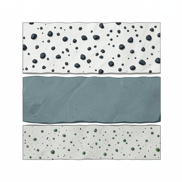
Lithostratigraphic Division of the Kometan Formation
AI-generated conceptual illustration (Sedimentary rock layers of the Kometan Formation in northern Iraq). It explains the idea and does not show study data.
View source evidence ↗Figures & tables
From the original paper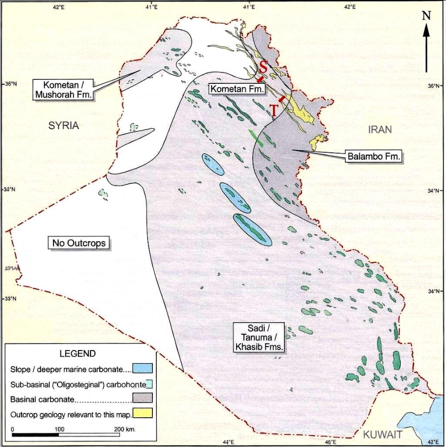 Figure 1
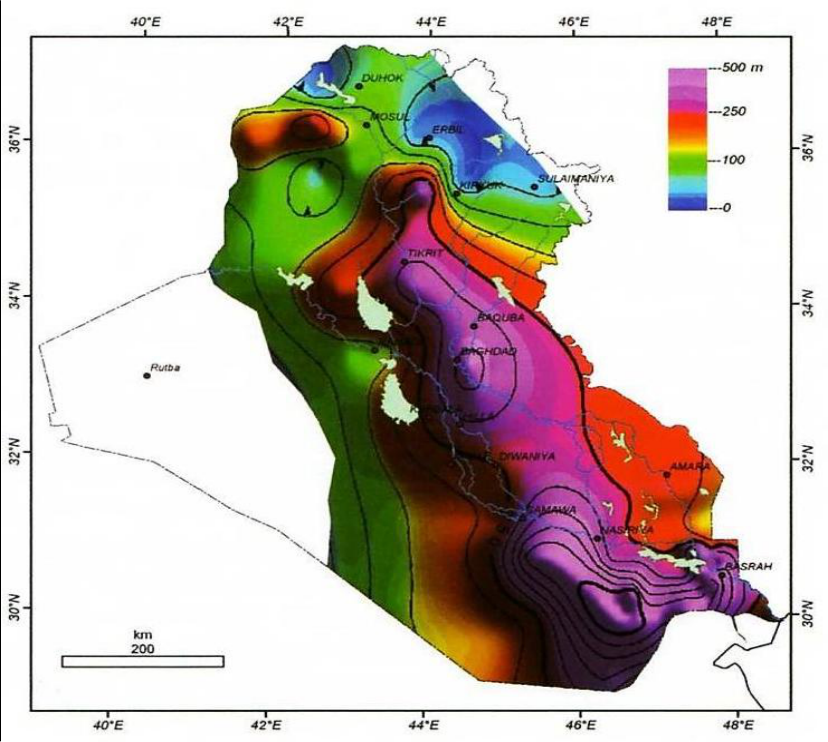 Figure 2
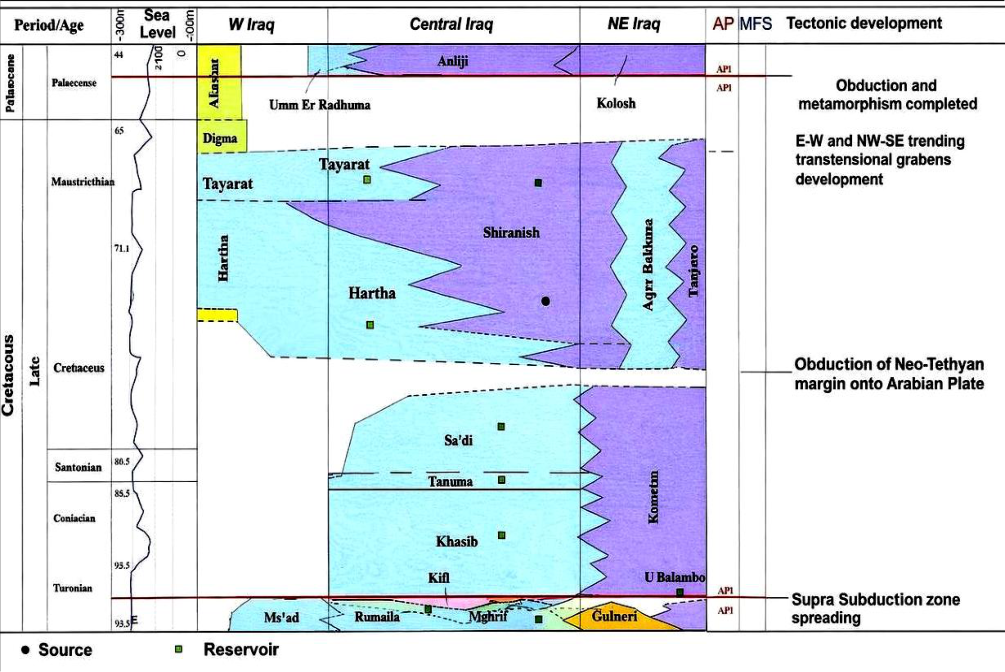 Figure 3
Introduction
Carbonate sequences in basins are important when analysing petroleum systems but, in particular Iraq, these sequences have not been studied in detail, on a sedimentological basis. Evaluating a petroleum system requires extensive sedimentological and organic geochemical studies of the source rock, which is generally identified with ancient sediments of basins deposited rapidly under deep burial conditions. A reservoir can also be intensely fractured basin carbonates, besides a source-rock. The Kometan Formations illustrate a hydrocarbon reservoir in Avana and Baba Domes in Kirkuk Field, producing oil from its upper sequences in Bai Hassan Field and generating gas in Jambur Field. One of the main taxonomic discussions we will address in this review is that of Buday (1980) [8] who suggested two basin carbonate sequences of Kometan and Mushorah formations be lumped into a single formation 'Kometan' and Mushorah will be intern facies. This proposal must be evaluated with geological proof and international standards stratigraphic nomenclature. If this is true, the areally merged Kometan Formation is potentially among the thickest Turonian-Early Campanian depositional cycle formations in northern Iraq.
Paleogeography
The mid-Cretaceous tectonic pulse caused the ceasing of the second depositional cycle. The unstable shelf was disturbed during this orogenic episode, which affected considerable thickening and facies changes in the Turonian-Lower Campanian secondary depositional cycle, which was relatively long-lasting. The most well-documented characteristics of this cycle include the progressive basinward migration toward southwest Iraq and the dominant northwest-southeast orientation of secondary basin axes. In this period, the northwestern part of Iraq was under the control of the elevated structural highs of the Mosul and Khleisia. These partitioned the Tethys Sea into the Mediterranean Tethys that extended through Syria, Lebanon, Palestine and Jordan. Conversely, the second was Indopacific Tethys which extended through Iraq, Arabian Gulf, Iran and Saudi Arabia (Buday, 1980) [8] . The Rutba High is another paleohigh that formed in western Iraq, particularly the regions west of the Abu Jir secondary zone. A small region affected by fault movement along basement blocks the Rutba and Khleisia highs east-west elongate. According to Buday (1980) [8] , the Qasimchaq's Older Barrier uplifted very strongly which had previously separated the Indopacific Tethys basin southwestward. During this period, there were only local basins that had open marine water connection. The Gulneri Formation is an argillaceous unit representing reduced sediments which accumulated in a secondary basin. Due to the partial erosion of its deposits within the secondary basins by the Turonian uplift, the lateral extents of this formation are poorly constrained. Ditmar et al. (1971, in Buday, 1980) [27,8] said that the Upper Turonian-Lower Campanian secondary cycle was separated into a number of secondary sub-basins by the subaqueous and emergent barriers. The facies distribution of sequences of this cycle indicates the existence of a large sedimentary basin encompassing the entire Iraq, where carbonates and marly limestones were laid down in shallower progressively shallower facies towards the Rutba and Khleisia paleohighs (Fig. 1) in the southwest. Due to the link with older local basins, Qamchuqa barrier topography has reduced morphological impact because of tectonic movements during the Early Turonian. The link to the Mosul High further widened the dam in the northwestern section. Ditmar et al. (1971, in Buday, 1980) [27,8] thus relate the thin sedimentary mantle concentrated over this barrier to its proximity to sea level or to its emergence. The present High Folded Zone and Jamjamal and Kirkuk secondary subzones in foothill zone are paleobasin zones. In the late Turonian, post-Hercynian tectonic movements returned and caused the uplift of the Qamchuqa barrier. During the same time, a long, deep basin developed parallel to its southwestern flanks in the east-west direction. It was probably in the Makhmur sub-zone of the Low Folded Zone and over the stable shelf margin bordering the Khleisia High, between Ana, Mushorah and Khleisia.
The entire territory of Iraq was part of this basin, which received the Kometan Formation facies in the north of the country and the Mushorah Formation facies in the western and northwestern parts of the country. According to Kaddouri (1982) [15] , Upper [27,8] , a reduction in depth and definition of the basin occurred southwestward of Mesopotamia (between southeastern Kut and Tigris). The region west of the Al Salman Zone was predominantly not affected by the Turronian-Campanian marine transgression except for the area to the north of the Rutba High which contained a local basin that was East-West orientated linked to Euphrates and effectively isolated Khleisia and Rutba highs.
Stratigraphy of the Kometan Formation
Significant tectonic events have taken place in Iraq in the Cretaceous time period, relating to the Kometan formation's stratigraphy of Iraq. The sequences of the formation have economic importance for petroleum exploration and the cement and construction stone industry. The lithology and topography of the site and sequences of Qeamchuqa Formation were helpful for the engineering of Dokan Dam and construction of Mountain Roads of Sulaymaniyah Region.
Type Section
The Kometan Formation is the name given to the rock walls of the Kometan or Ain Dza villages in northern Rania city northeast Iraq. As per Bellen et al. (1959) [7] , Dunnington (1959) [7] was the first to write description. Almost 400 meters from the village center, the formation base is an outcrop of Kometan surface. The uppermost layers of the formation are located about 220 m from the village. Type section is located at 44°48'18"E, 36°24'28"N. According to the authors Bellen & al (1959) [7] , based on this fauna, the formation is assigned an Early Turonian-Santonian age and the lower and upper contacts are of two dimensions, unconformable.
Lithostratigraphic Units
The Kometan Formation is generally divided into three lithostratigraphic units according to two complementary criteria: (1) character of bedding and (2) composition. The same three sub-categories are in the scheme of the Northern Oil Company, and in the way that has been suggested by Al-Jubbury (1991) [22] , Hammodi (1995) [24] , Al-Dhaif, and Al-Khaffaf (2005) [25] .
Lower Unit
The lower unit of the type section, which is 12 m thick, consists of fine white to light-grey limestones, at the base of which some glauconite occurs (Bellen et al., 1959). As per al-Jubbury (1991) [22] , the Sarjanar -Sulaymaniyah area's limestone is hard, white-yellowish, well bedded, finer grain limestone with chert balls, iron oxide patches and many planktonic fossils (Ostracoda, Globotruncana, Oligostegina), and fractures filled with calcite. Major diagenetic processes include silicification, dissolution, and compaction.
According to Hammodi (1995) [24] , Kirkuk K-117 unit has gray-white chalky limestone (wackestone-packstone) intercalated with thin shales. The white limestone material of the unit (62m) in Jambur-46 (Al-Dhaif,) contains argillaceous limestone.
Middle Unit
This middle unit consists of thick sequences of fine-grained lead gray limestone rich in chert nodules in its upper part (Bellen et al., 1959) [7] Al-Jubbury (1991) [22] describes the Sarjanar brown well-bedded carbonate 55m to have thin beds of chert (5 to 10cm), chert nodules and pyrite grains.
The unit is very rich in planktonic foraminifera such as Globotruncana, Heterohelix, and Hedbergella along with calci-spheres. Other characteristics include a very high amount of bioclasts, amino and abundant benthic fauna and important fractures and veins filled with calcite. Diagenetic processes include compaction, recrystallisation, silicification, dissolution. According to Hammodi, Kirkuk K-117 refers to laminated shale that alternates with blackto-greenish lead limestone containing pyrite. This description is similar to Al-Dhaif's description (82 m) Jambur-46.
Upper Unit
The Upper Unit, 15 m thick in the type section, consists of fines grained, white to light grey limestone intercalated with chert nodules in thin sequence. In his 1991 work, Al-Jubbury discussed the Sarjanar area's formation (20 meters). He referred to it as a well-bedded gray limestone that is rich in bioturbation features. Also present in the limestone are calcareous nodules (3 cm) and bits, chert nodules and pyrite in the top sequences. The amount of benthic fauna, quartz grains, carbonate clasts and bioclasts are more in this unit together with planktonics. Principal diagenetic processes include recrystallization, silicification, compaction and dissolution. Kirkuk K-117 indicated marly limestone bearing Calcispheres and pyrite were reported by Hammodi (1995) [24] for this unit. Jambur-46 Al-Dhaif described a 63 m depth of a light brown limestone alternation.
Age
Although beyond the scope of this review, biostratigraphic evidence from previous studies supplies the vital timeframe needed for age derivation. It is the consensus opinion that the Kometan Formation, northeastern Iraq, is Late Turonian to Early Campanian in age; and that the Mushorah Formation, northwestern Iraq, is Early Santonian to Early Campanian in age. Kometan facies were laid down in eastern Iraq as early as the Late Turonian and remained active until Early Campanian time. In northwestern Iraq, conditions for the deposition of Mushorah facies deposits did not exist until Early Campanian.
Thickness and Distribution
Data on the thicknesses of the Kometan and Mushorah formations published show significant lateral variation in their areas. All variation can be represent for each formation and merger context. Kometan's thickness variation has several suggested causes. Haddad (2004) [23] stated that the absence of the formation in Jamjamal-2 and the reduced thickness of the formation in Baiji-1, Hamrin, and Ajeel fields is due to a hiatus in deposition or a sediment gravity flow down a steep slope. According to Schlager and Kenter (1990, in Hammodi, 1995) [24] , slope angles greater than two degrees prevent sediment accumulations from being found on basin floors. Hammodi (1995) [24] also stated that stratigraphic reworking would result in middle-unit redeposition due to strike-slip tectonic movement along important shallow-water slopes. The Kometan Formation isopach map (Hammodi, 1995) [24] shows a northwest-southeast basin axis orientation agreement with the general structural trend of the Turonian-Lower Campanian depositional cycle. Two secondary subbasins are delineated, one in Kirkuk and the other trending to Khanaqin. According to Fig. 1, in the north-western sector the axis of the basin bends to the NE-SW direction because of the Mosul High. Additional thickness error is caused due to facies interfingering of Kometan, Mushorah, and their Balambo equivalents during drilling.
Formation Contacts 8.1. Lower Contact
The base contact of Kometan Formation varies from one site to another and otherwise on the underlying formation. Underneath it, Balambo, Qamchuqa, Dokan, and Gulneri formations, mostly Cenomanian in age. As reported by Dunnington (1953) [28] in Bellen et al (1959) [7] , the Balambo Formation in northeastern Iraq has an unconformable lower contact due to either non-deposition or an erosional surface which is found at the Balambo Formation. Two evidence has been assigned for glauconite enrichment on the base of Kometan. The bioturbation on the upper surface of Balambo. As per Bellen et al. (1959) [7] , the lower contact of the Dokan Formation in Kirkuk K-116 well is represented by a thin erosional unit of black shale like the Gulneri Formation in Sulaymaniyah region. There are also records of contact character views. Sarraj (2006, in Karim et al., 2008) [16] and Karim et al (2008) [16] suggested a conformable, gradational lower contact between the Dokan and Kometan formations in the Dokan area because of the lack of subaerial erosional features and that sedimentation continued into the transitional zone. Zardasht and Karim (2009) [19] similarly concluded that the upper surface of the Gulneri does not contain conglomeratic features, paleosol features or erosive features. This means that the base of the Gulneri formation is gradational. As Sadooni and Al-Sharhan (2003) [17] and Jassim and Goff (2006) [14] confirm, the junction with the Qamchuqa Formation suggested another about fauna stop and basal glauconite.
Upper Contact
The Kometan Formation's upper contact touches only one unit and displays uniformity, while the lower contact displays non-uniformity. This layer is the Shiranish formation. As reported by Bellen et al. (1959) [7] , in the type section the upper contact is unconformable with the Campanian Shiranish Formation, which is separated by a thin conglomerate that contains fine pebbles (diameter <2 cm) and sandstone fill of well-rounded green glauconite grains and fine carbonate bioclasts from the Kometan. The highest Kometan sequences have a bed at the top with erosion and cavities. Many kinds of contacts have been identified for the top boundary. Karim et al. (2008) [16] identified 3 kinds of upper contact which include; (1) Gradational e.g. Sections of Jaq-Jaq, Azimara and Azimara Tourist Valley with glauconitic-bored e.g. upper and lower Dikan, Kometan village and Hizob Bridge sections and sharp e.g Qamchuqa Valley.
According to Hammodi (1995) [24] , at Kirkuk K-117, there is a gradational contact of a type with an uncontroversial character between the tandawa character and a Jambur J-13 with space variability nature. Youkhana; Al-Jubbury 1991; and Saied 1978 [22,18] are of opposite view and regard the upper contact as conformable because of continuous depositional features without erosional markers in northeastern Iraq.
Formation Equivalents 9.1. Local Equivalents
In Iraq, the Kometan Formation of northeastern Iraq is laterally equivalent to the Late Turonian-Santonian part of the Balambo Formation, and to the Mushorah Formation (Coniacian-Santonian) of northwestern Iraq. In centralsouthern Iraq, the Khashib (Late Turonian) and Tanuma (Coniacian-Santonian) form the equivalent of the middle Kometan sequences. Lower sequences of the Saadi Formation (Late Santonian) correlate with the upper Kometan (Buday, 1980) [8] fig ( 3).
Regional Correlatives
The Aruma Formation in Saudi Arabia is equivalent to the upper Kometan sequences. In western Syria and Jordan, the lower Kometan corresponds to the Judea Formation and the upper Kometan corresponds to the Belqa Series. Correlatives of the phosphatic Surkhaneh formation and the red Dairu beds in central Syria. The sequences of the Middle Ghudair Formation in southeast Kuwait are Kometan equivalents, likewise for the phosphatic Karababa Formation in southern Turkey. In southwestern Iran's Lurestan area, the Bangestan Group (Sarvak and Ilam formations) is the analogue for the middle and upper Kometan and the Gurpi Formation for the upper Kometan (Lurestan and Khuzestan; James and Wynd, in Hammodi, 1995; Buday, 1980) [24,8] . Dunnington (1953, in Bellen et al., 1959) [28,7] [27,8] , the Mushorah sequences, especially those in their upper parts, were facies in the Kometan Formation in the north-western region. Youkhanna, in Buday, 1980) [8] established three major and two minor biostratigraphic zones for the Kometan sequences based on the planktonic Globotruncana assemblages. Saied (1978) [8] set up five biozones in Injana-5 well in northern Iraq. Abdul-Muniem and Saied identified many foraminifera from Shaqlawa (1979) [4] Kaddouri (1982) [15] showed that late turonianearly campanian cycle deposits from northwestern Iraq extend into northeastern Syria. Al-Tamimi (1986) [20] divided the sequence into four biostratigraphic zones while Al-Jubbury (1991) [22] classified it into three lithological units. Hammodi 1995 interpreted the Kometan depositional environment as outer shelf to upper slope, extending into mid-slope on an occasional basis and a five-zone biostratigraphy was established. Al-Dhaif (1995) [24] confirmed the limestone-argillaceous limestone alternation character. Abwai and Hammoudi created five Kirkuk-area biozones in 1999. Haddad (2004) [23] proposed a deep setting for the formation in the middle-to-outer ramp, an environmental interpretation that Al-Khaffaf (2005) [25] confirmed for the Dokan area. AL-Barzinjy (2008) [5] noted that the Kometan outcrops are characterized by a particularly high concentration of siliceous nodules that associated with stylolite veins due to high overburden pressure. According to Karim et al. (2008) [16] , three types of contact exist with the Shiranish Formation above. Taha and Karim (2009) [19] interpreted the conformable, gradational Gulneri-Kometan contact in Dokan as a possible merger of the two formations. According to Aqrawi et al. (2010) [6] , hydrocarbon generation from Kometan in the fields of Avana, Baba domes, Bai Hassan, Jambur and Taq Taq is due to a significant extent of fracturing the formation despite its low matrix porosity and permeability.
Review of Previous Studies
Review of Previous Studies
Kometan and Mushorah: One Formation or Two?
Mushorah Formation was first defined by Dunnington (1953 in Bellen et al. 1959) [28,7] from well Mushorah-1 (Mu-1), drilled on Mushorah Dagh anticline in far northwestern Iraq, in the foothills zone. The type section predominantly contains partially silicified globotruncanid limestones and marly limestones. Laterally distinct facies parameters: sequences in Ain Zalah wells are well bedded while those of the Makhmur and Samarra wells show dolomitization, anhydrite and chert nodules (Bellen et al., 1959; Johnson, in Jassim and Goff, 2006) [7,14] . On the other hand, Bellen et al. (1959) [7] states that the facies of Mashurah, besides being rich in Oligostegina fossils, also includes. Guembelina sp., Globigerina cretacea, G. lapparenti bulloides, G. lapparenti Bulimina prolixa, Anomalina sp., Miliolides, Ostracods, and Gastropods. Mushorah facies are predominantly element in the Makhmur zone of the foothills belt. The depositional basin of typical Mushorah facies extends northwestward across Iraq into Syrian territory and southward to cover the northern flanks of the stable shelf. Towards the south west, Mushorah facies gets inter-fingered with Saadi Formation facies which are not well defined towards south east. The mushorah facies are partly equivalent to the Balambo Formation in northeast Iraq and the Sakhn and Karababa formations in Turkey. The Mushorah Formation is considered an upper Kometan sequences sub-basin equivalent for most researchers. There are two opposing schools of thought with regards to its taxonomy. According to the first school (Ditmar et al., 1971, in Buday, 1980; Al-Tamimi, 1986; Hammodi, 1995) [27, 8, 20, 24] , Mussorah and Kometan Formation should be combined. This school considers the Mushorah as an internal facies. The second school (Dunnington, 1953, in Bellen et al., 1959; Hart, 1960; Chatton and Hart, 1960; Northern Oil Company, 1988-1992; Haddad, 2004) [28,7,11,23] supports the maintenance of Mushorah as a lithostratigraphic unit of its own. As observed by Hart in 1960, lenticular Mushorahequivalent facies in the Kirkuk Field wells (Qarajuq-1, Bai Hassan-13, Kirkuk-116) differ from the Ain Zalah wells. Organic components from Early Campanian problematicum and planktonic foraminiferal assemblages, not seen before in the Mushorah type section, are present in the Kirkuk wells. According to Ditmar et al. (1971, in Buday, 1980) [27,8] , Mushorah facies in Kometan sequences of Kirkuk, Makhmur and Bakhmah are of Early Santonian-Early Campanian ages. They are thus younger than "normal" Kometan sequences despite their lithological similarity. This is not due to increased slope gradients on the middle ramp. Haddad (2004) [23] supported the independent status of Ash-1 based on its origin in a sub-pelagic slope environment next to the shelf. Haddad claims that wells Kirkuk-116, Bai Hassan-81, Khabbaz-1 and Qarajuq-1 contain only normal Mushorah facies while Kirkuk-117 and Kuwair-2 contain Mushorah facies interfingering with Kometan. In northeastern parts of Iraq, the Mushorah facies disappear altogether and are entirely replaced by Kometan facies, although Early Santonian-Early Campanian deposits may be present in the lower Shiranish basin facies. In contrast, the Kometan facies occupies extensive areas of central and northern Iraq, covering most of the southeastern margins of the interference zone, and the high-fold and foothills zones south of the Great Zab River (Jassim and Goff, 2006) [14] .
Conclusions
The Kometan Formation is an important basin carbonate unit in northern Iraq, and has established economic significance as a hydrocarbon reservoir-by virtue of its fracture porosity-as well as a potential source rock. The stratigraphic age of northeast Iraq is Late Turonian to Early Campanian. At the type section near Rania, a formation is 36 m thick and shows marked thickness variation over its area due to basin paleotopography and tectonic controls. Although in certain localities gradational contacts have been documented, the lower and upper contacts are basically unconformable. A three-fold division of the LUSU into Lower, Middle and Upper Units provides an easy lithostratigraphic framework for use in various outcrop and subsurface sections. The presence of regional correlatives in Saudi Arabia, Jordan, Syria, Turkey and Iran and Kuwait confirm the broader significance of the formation in the Cretaceous. The question of whether to combine the Kometan and Mushorah formations remains contentious: lithological similarities support their unification, but distinct depositional environments, age differences in some localities, and the requirements of formal stratigraphic nomenclature support treating them as separate formations pending a formal
Figures and tables from the paper
References
28 in the original paper- Aqrawi AAM, Goff JC, Horbury AD, Sadooni FN. The petroleum geology of Iraq. Scientific Press; 2001. 424 p.
- Abawi TS, Hammoudi RA. Planktonic foraminiferal stratigraphy of Shiranish Formation, SulaimaniahDokan region, northeastern Iraq. Rev Esp Micropaleontol. 1999;14(1):153-164.
- Abawi TS, Mahmood SA. Biostratigraphy of the Kometan and Gulneri formations (Upper Cretaceous) in Jambur Well No. 46, northern Iraq. Iraqi J Earth Sci. 2004;5(1):1-8.
- Abdel-Munium A, Saied VY. Micropaleontology of large sediments in Erbil, Shaqlawa, Koisinjaq and Rania areas, northern Iraq. Directorate General of Geological Survey and Mineral Investigation; 1979. Unpublished report. p. 1-109.
- Al-Barzinjy ST. Origin of chert nodules in Kometan Formation from Dokan area, northeastern Iraq. Iraqi Bull Geol Min. 2008;4(1):95-104.
- Aqrawi AAM, Goff JC, Horbury AD, Sadooni FN. The petroleum geology of Iraq. Scientific Press; 2010. 424 p.
- Van Bellen RC, Dunnington HV, Wetzel R, Morton DM. Lexique stratigraphique international: Asie, Fascicule 10a, Iraq. Paris: Centre National de la Recherche Scientifique; 1959. 333 p.
- Buday T. The regional geology of Iraq: stratigraphy and paleogeography. Mosul: Dar Al-Kutub Publishing House; 1980. 445 p.
- Buday T, Jassim SZ. The regional geology of Iraq. Vol. 2. magmatism and metamorphism. Baghdad: State Establishment of Geological Survey and Mineral Investigation; 1987. 352 p.
- Dunham RJ. Classification of carbonate rocks according to depositional texture. In: Ham WE, editor. Classification of carbonate rocks. AAPG Memoir 1. Tulsa: American Association of Petroleum Geologists; 1962. p. 108-121.
- Hart E. Kometan and Mushorah formations relationship. Kirkuk: NOC Library; 1960. Unpublished report.
- Jassim SZ, Goff JC. Geology of Iraq. Prague: Dolin; Brno: Moravian Museum; 2006. 341 p.
- Jassim SZ, Buday T. Late Turonian-Danian megasequence AP9. In: Jassim SZ, Goff JC, editors. Geology of Iraq. Prague: Dolin; Brno: Moravian Museum; 2006. p. 141-154.
- Jassim SZ, Buday T. Units of the unstable shelf and the Zagros suture. In: Jassim SZ, Goff JC, editors. Geology of Iraq. Prague: Dolin; Brno: Moravian Museum; 2006. p. 71-83.
- Kaddouri N. Late Turonian-Early Campanian sedimentation in Iraq. J Geol Soc Iraq. 1982;15(1):9-18.
- Governorate, Kurdistan Region, northeastern Iraq. Iraqi Bull Geol Min. 2008;4(2):16-27.
- Sadooni FN, Al-Sharhan AS. Stratigraphy, microfacies and petroleum potential of the Mauddud Formation (Albian-Cenomanian) in the Arabian Gulf Basin. AAPG Bull. 2003;87(10):1653-1680.
- Saied VY. Biostratigraphy of Upper Cretaceous sediments in the lower part of Well Injana No. 5, northeastern Iraq. Baghdad: SOM; 1978. Unpublished report.
- Taha ZA, Karim KH. New ideas about Gulneri Shale Formation (Early Turonian) in Dokan area, Kurdistan Region, northeastern Iraq. Iraqi Bull Geol Min. 2009;5(2):29-39.
- Al-Tamimi FM. Microfossil study of the Kometan Formation for paleoenvironmental determination [MSc thesis]. Baghdad: University of Baghdad, College of Science; 1986. 174 p.
- Al-Jubouri AI, Haddad SN, Al-Juwaini QS. Microfacies analysis of the Dokan Formation in selected wells from Jambur Field, northeastern Iraq. Rafidain J Sci. 2007;13(1):62-76.
- Al-Jubouri QMH. Geology and microfacies of the Kometan and Shiranish formations in the Sarjanar area, Sulaymaniyah, northeastern Iraq [MSc thesis]. Erbil: Salahaddin University, College of Science; 1991. 101 p.
- Haddad SN. Sequence stratigraphy of the Middle Turonian-Early Campanian formations in selected wells from northeastern Iraq [PhD dissertation]. Mosul: University of Mosul, College of Science; 2004. 173 p.
- Hamoudi RA. Stratigraphy of the Turonian-Early Campanian depositional subsequence in selected wells in Iraq [PhD dissertation]. Mosul: University of Mosul, College of Science; 1995. 215 p.
- Al-Khaffaf AO. Stratigraphy of the Kometan Formation (Upper Cretaceous) in the Dokan-Ain Diza area, northeastern Iraq [MSc thesis]. Mosul: University of Mosul, College of Science; 2005. 79 p.
- North Oil Company. Final report of Well Jadida-1 (Jd1). Kirkuk: North Oil Company Library; 1977. Unpublished report.
- Ditmar V, et al. Geological conditions and hydrocarbon prospects of the Republic of Iraq. Vol. 1: Northern and central parts. Baghdad: INOC; 1971. Unpublished report.
- Dunnington HV. 1953. Stratigraphic distribution of oil fields in Iraq and Iran. In: Weeks LG, editor. Habitat of oil. Tulsa: American Association of Petroleum Geologists; 1953. p. 764-805