
Research article · 2026 · Full text
International Journal of Geography Geology and EnvironmentGeological and geophysical characterisation of subsurface formations for engineering applications in Uyo, Akwa Ibom state, Nigeria
Volume 8(2) · Pages 123–129 · DOI: 10.22271/27067483.2026.v8.i2a.483 ↗
Research areasGeophysical and Geoelectrical MethodsGeotechnical and construction materials studiesGroundwater and Watershed Analysis
Abstract
Author-writtenThis study presents a geological and geophysical characterisation of subsurface formations in Uyo, Akwa Ibom State, Nigeria, using electrical resistivity sounding for engineering and hydrogeological applications. Vertical Electrical Sounding (VES) with the Schlumberger electrode configuration was employed to delineate subsurface lithology, assess soil competence, identify aquifer horizons, and evaluate factors relevant to engineering foundation stability within the Niger Delta sedimentary basin. The results indicate heterogeneous subsurface conditions consisting mainly of clay, sandy clay, fine sand, and coarse sand formations. Apparent resistivity values ranged approximately from 28 Ωm to over 600 Ωm, reflecting variations in lithology, grain size distribution, and moisture content. Near-surface conductive layers were interpreted predominantly as clay-rich or silty soils with relatively lower bearing capacity, while intermediate resistivity zones correspond to sandy clay or fine sand formations exhibiting moderate mechanical competence. Higher resistivity layers occurring at moderate depths were interpreted as coarse sand or sand-gravel formations representing competent geotechnical units suitable for engineering foundations and potential groundwater occurrence. Derived Dar Zarrouk parameters indicate weak to moderate overburden protective capacity, suggesting some vulnerability to environmental influences, whereas transverse resistance values suggest generally moderate to high subsurface competence. The results demonstrate favourable conditions for engineering development in areas underlain by resistive sandy formations while emphasising the importance of integrated geophysical and geotechnical investigations for sustainable infrastructure planning in the Niger Delta region.
Summary
Source-checkedPlain-language reading of the full paper, prepared with AI and checked against the text. Each point links to the authors' own words.
Why it matters
- Rapid urban and infrastructural growth in the Niger Delta has created a high demand for accurate subsurface data to support construction and environmental management. View evidence ↗
- Failing to properly characterize the subsurface before building can lead to higher costs, groundwater intrusion, excessive settlement, and structural instability. View evidence ↗
- Uyo is located in the Niger Delta Basin and is primarily characterized by the Benin Formation, which consists of unconsolidated sands mixed with clay and sandy clay layers. View evidence ↗
The question
- The study aims to provide a detailed evaluation of Uyo's subsurface formations using electrical resistivity to assess aquifer occurrence, environmental vulnerability, and suitability for foundations. View evidence ↗
What they did
- Researchers used Vertical Electrical Sounding (VES) with a Schlumberger electrode configuration to identify subsurface lithology and evaluate soil competence for engineering stability. View evidence ↗
- The survey was conducted across four representative Vertical Electrical Sounding (VES) stations in the study area. View evidence ↗
- Data inversion modeling showed root-mean-square (RMS) error values between 3% and 8%, which the authors consider an acceptable agreement between observed and calculated data. View evidence ↗
What they found
- The near-surface layer (3 to 5 m thick) consists of clayey sand, clay, or silt with resistivity values from 28 to 40 Ωm, indicating weak soils. View evidence ↗
- The second subsurface layer, interpreted as fine sand or sandy clay, has a thickness of 7 to 9 m and resistivity values between 110 and 180 Ωm. View evidence ↗
- The third layer consists of coarse sand or sand-gravel with high resistivity values (460 to 610 Ωm), making it a competent unit for engineering foundations. View evidence ↗
- Competent geotechnical layers were found at depths of 10 to 14 m, characterized by resistivity values between 460 and 610 Ωm. View evidence ↗
- Longitudinal conductance values ranged from 0.13 to 0.20 Siemens, indicating a weak to moderate protective capacity of the overburden. View evidence ↗
- Near-surface resistivity values between 28 and 40 Ωm indicate soils that may be slightly to moderately corrosive to buried metallic infrastructure. View evidence ↗
What it means
- The authors conclude that Uyo's subsurface is generally suitable for engineering development, especially in areas with competent sandy formations at moderate depths. View evidence ↗
- The authors recommend integrating geophysical, geotechnical, and hydrochemical investigations to ensure sustainable design due to shallow clay layers and environmental factors. View evidence ↗
- The authors state that their interpretations are preliminary geophysical indicators and should not be used as definitive engineering design parameters without further geotechnical testing. View evidence ↗
Visual summary
3 visualsIllustrations explain the paper; charts are replotted from the paper's own table values.
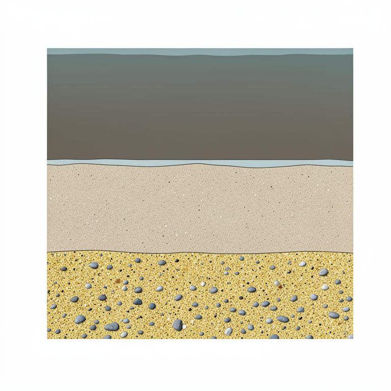
Subsurface Lithology Profile
AI-generated conceptual illustration (Subsurface geological formations in Uyo, Nigeria). It explains the idea and does not show study data.
View source evidence ↗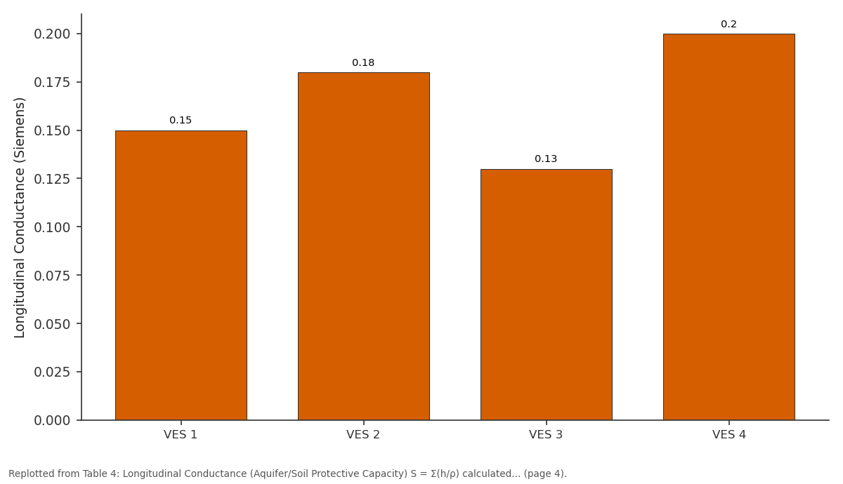
Longitudinal Conductance (Siemens): VES 1 vs VES 2 vs VES 3 vs VES 4
Replotted from Table 4 (page 4) of the original paper. Every bar is the paper's own table value.
View source evidence ↗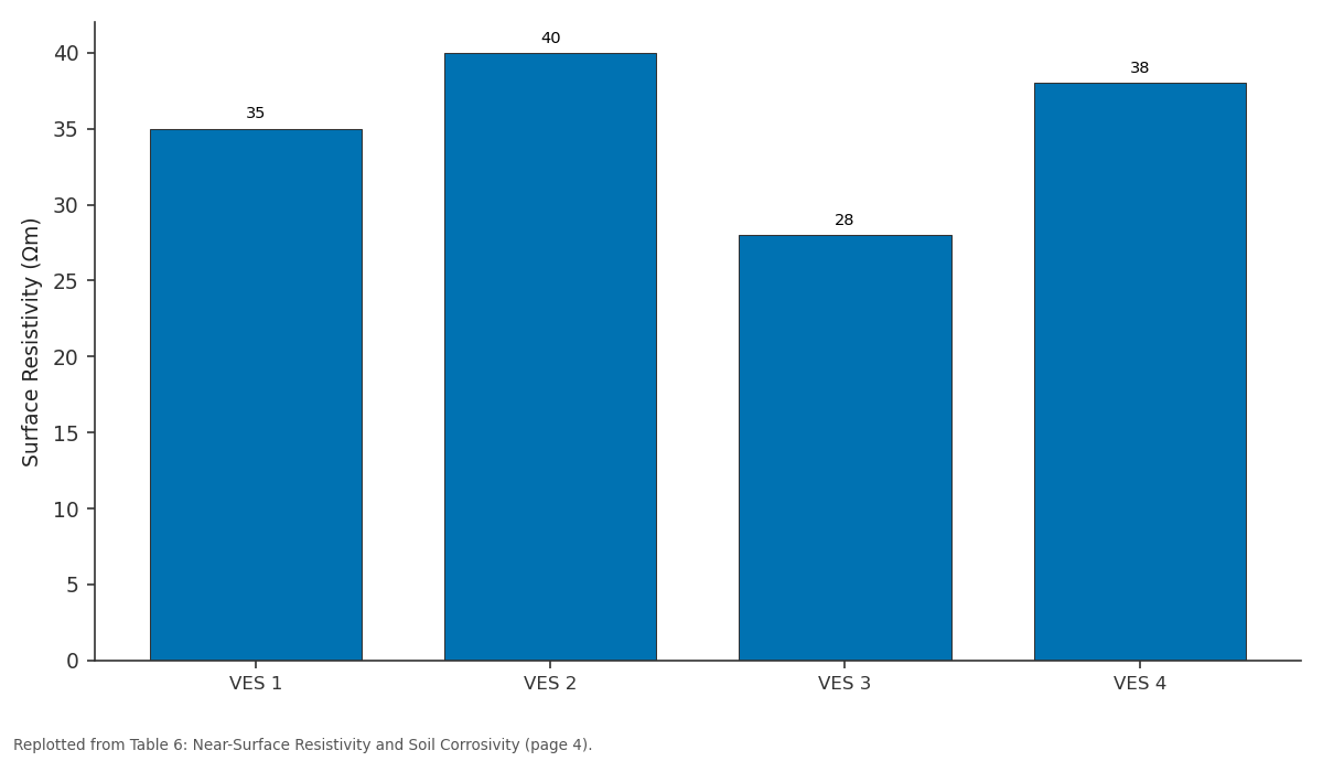
Surface Resistivity (Ωm): VES 1 vs VES 2 vs VES 3 vs VES 4
Replotted from Table 6 (page 4) of the original paper. Every bar is the paper's own table value.
View source evidence ↗Figures & tables
From the original paper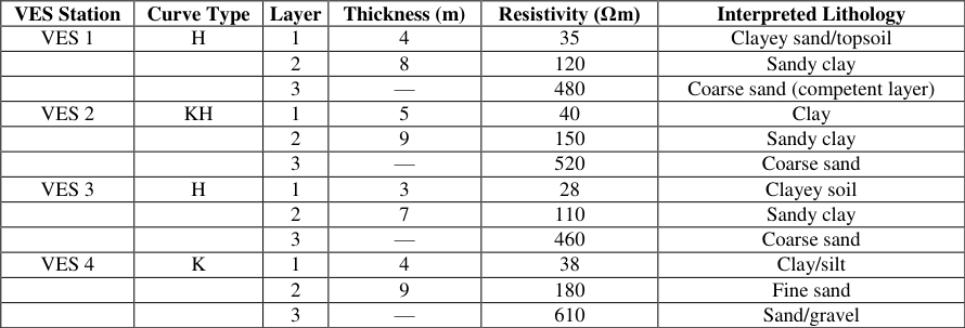 Table 1
 Table 2
 Table 3
 Table 4
 Table 5
 Table 6
 Table 7
Introduction
Rapid urban development and infrastructural expansion in many parts of the Niger Delta have increased the demand for reliable subsurface information for engineering construction, groundwater development, and environmental management. In sedimentary environments such as Uyo, Akwa Ibom State, Nigeria, variability in subsurface lithology, soil competence, and groundwater conditions presents significant challenges for foundation design, site selection, and sustainable infrastructure planning. Inadequate subsurface characterisation prior to construction has been associated with structural instability, excessive settlement, groundwater intrusion, and increased engineering costs (Facazio et al., 2002) [15] . Geophysical methods, particularly electrical resistivity techniques, are widely applied for subsurface investigation because they provide rapid, cost-effective, and non-destructive means of evaluating lithological variations, aquifer distribution, soil competence, and environmental conditions. Electrical resistivity sounding has proven especially effective in sedimentary terrains where variations in grain size, clay content, moisture saturation, and pore fluid conductivity significantly influence electrical properties (Asfahani, 2013; Dewashish et al., 2014) [5,9] . Such variations allow reliable differentiation between clay-rich formations, sandy layers, and competent geological units relevant to engineering applications.
The geological setting of Uyo lies within the Niger Delta Basin, dominated by coastal plain sands of the Benin Formation, composed mainly of unconsolidated sands interbedded with clay and sandy clay layers. These formations exert strong control on groundwater occurrence and engineering stability. Clay-rich strata often exhibit low bearing capacity and high compressibility, whereas sandy formations typically provide better drainage and foundation competence (Okiongbo & Akpofure, 2012) [20] . Similar geoelectric investigations in southern Nigeria have demonstrated the usefulness of resistivity methods for aquifer delineation and engineering assessment in such sedimentary environments (Ikpe et al., 2025) [16] . In addition to engineering considerations, environmental pressures associated with urbanisation, industrial activities, and petroleum exploration in the Niger Delta may influence soil properties and groundwater quality. Integrated geological and geophysical approaches have therefore been recommended for comprehensive subsurface evaluation and sustainable environmental management (Adiat et al., 2013; Adeniyi et al., 2013) [2,1] . Although electrical resistivity sounding has been widely applied in groundwater exploration and engineering investigations within the Niger Delta region, site-specific integrated assessments combining subsurface lithological characterisation, engineering competence evaluation, and hydrogeophysical protective capacity remain limited for Uyo and its immediate environs. This study, therefore, addresses this gap by providing a detailed resistivity-based evaluation of subsurface formations in Uyo, with emphasis on foundation suitability, aquifer occurrence, and environmental vulnerability. The findings contribute location-specific data that can support infrastructure planning, groundwater management, and environmental monitoring within rapidly urbanising sedimentary environments of southern Nigeria.
Materials and Methods
Materials and Methods
Study Area and Geological Setting
The study was conducted in Uyo, Akwa Ibom State, Nigeria, located within the Niger Delta sedimentary basin. The area is predominantly underlain by the Benin Formation, consisting mainly of unconsolidated coastal plain sands interbedded with clay and sandy clay units. These formations influence subsurface electrical properties, groundwater occurrence, soil competence, and engineering stability. The humid tropical climate, characterised by high rainfall and shallow groundwater conditions, promotes infiltration processes that can affect both geophysical responses and engineering suitability of near-surface soils.
Geophysical Survey Method
Electrical resistivity sounding was employed as the primary geophysical method for subsurface characterisation because of its effectiveness in delineating lithological variations, identifying competent foundation layers, and evaluating groundwater influence on engineering stability. Vertical Electrical Sounding (VES) using the Schlumberger electrode configuration was adopted due to its sensitivity to vertical resistivity variations and suitability for sedimentary environments. The array involves progressive expansion of the current electrode spacing while maintaining relatively smaller potential electrode spacing, thereby enabling deeper subsurface investigation with good resolution.
Field Data Acquisition
Field measurements were carried out using a digital resistivity meter (terrameter), stainless steel electrodes, insulated cables, measuring tapes, a hammer, and a Global Positioning System (GPS) receiver for accurate spatial referencing. Current was injected into the ground through two outer electrodes (A and B), while the potential difference was measured across the inner electrodes (M and N). The apparent resistivity (ρa) was determined using:
where ρa is the apparent resistivity (Ωm), ΔV is the measured potential difference (volts), I is the injected current (amperes), and K is the geometric factor dependent on electrode spacing. For the Schlumberger array, the geometric factor K is expressed as:
where AB is the distance between current electrodes and MN is the distance between the potential electrodes. Electrode spacing was progressively increased to achieve greater investigation depth. Survey stations were selected to minimise cultural noise such as buried metallic infrastructure and electrical interference. A total of four Vertical Electrical Sounding (VES) stations were established across the study area to provide representative subsurface coverage. Station locations were selected based on accessibility, minimal anthropogenic interference, geological representativeness, and relevance to engineering development zones. The spatial distribution was designed to capture lateral variations in lithology and groundwater conditions within the sedimentary terrain.
Data Processing and Inversion
Apparent resistivity data were plotted against electrode spacing on log-log scales to produce resistivity sounding curves. Preliminary interpretation involved curve matching with theoretical master curves, followed by computerassisted inversion to obtain true layer resistivities and thicknesses. Iterative modelling was performed until acceptable root-mean-square (RMS) error values were achieved between observed and calculated resistivity data. The resulting curve types, including H, KH, and K curves, were used to infer subsurface lithological layering typical of sedimentary terrains. Root-mean-square (RMS) error values obtained during inversion modelling ranged between approximately 3% and 8%, indicating acceptable agreement between observed and calculated resistivity data. These values suggest reliable geoelectric models suitable for lithological interpretation, although uncertainties inherent in geophysical inversion remain recognised.
Lithological and Engineering Interpretation
Lithological interpretation was based on established resistivity ranges in coastal sedimentary environments. Low resistivity values were interpreted as clay or silty formations, moderate values as sandy clay or fine sand, and high resistivity values as coarse sand or gravel formations. Particular emphasis was placed on identifying competent subsurface layers suitable for engineering foundations. Depth to competent layer, overburden thickness, and subsurface competence were inferred from layer resistivity and thickness parameters.
Dar Zarrouk Parameter Estimation
Hydrogeophysical parameters relevant to engineering assessment were derived using Dar Zarrouk relationships. Longitudinal conductance (S), which reflects overburden protective capacity and soil competence, was calculated as:
where h is the thickness of each layer and ρ is the corresponding resistivity. Higher S values generally indicate increased clay content and improved protective capacity. Transverse resistance (T), used as an indicator of subsurface competence and groundwater potential, was calculated as:
Higher T values typically correspond to thicker and more resistive formations associated with stronger geotechnical competence and favourable groundwater conditions. However, these parameters were interpreted qualitatively and not directly equated to hydraulic transmissivity without supporting hydrogeological data.
Soil Corrosivity Assessment
Near-surface resistivity values were used as indicators of soil corrosivity potential. Low resistivity soils are generally more conductive and may exhibit higher corrosivity towards buried metallic infrastructure due to increased moisture content and ionic concentration. This assessment provided supplementary information relevant to engineering design and infrastructure durability.
Quality Control Measures
Quality assurance procedures included proper electrode grounding to minimise contact resistance, repeated measurements at each station for consistency, instrument calibration prior to data acquisition, and careful selection of survey locations to minimise anthropogenic interference. Data inversion incorporated RMS error monitoring to ensure reliable geoelectric models and geologically plausible interpretations.
Data Presentation and Analytical Approach
Interpreted resistivity layer parameters, Dar Zarrouk indices, and engineering suitability indicators were presented in tabular form to facilitate clear hydrogeophysical interpretation. Comparative analysis of resistivity distribution, overburden characteristics, competent layer depth, and soil corrosivity potential was undertaken to assess subsurface suitability for engineering applications in the study area.
Results
Table 1 [5] . Electrical resistivity investigations remain particularly effective in distinguishing competent sandy formations from claydominated units because of their contrasting electrical properties (Dewashish et al., 2014) [9] . While electrical resistivity data provide valuable indirect information on subsurface competence, engineering parameters such as bearing capacity, compressibility, and shear strength require confirmation through geotechnical testing, including borehole sampling, laboratory analysis, and in situ penetration tests. Consequently, interpretations presented in this study should be regarded as preliminary geophysical indicators rather than definitive engineering design parameters (Dewashish et al., 2014) [9] . The shallow low-resistivity layers identified in the results, typically between about 28 Ωm and 40 Ωm, are interpreted primarily as clayey or silty soils with relatively high moisture retention. Such formations are generally associated with reduced bearing capacity and increased compressibility, which may pose challenges for engineering foundations. Studies of aquifer and soil characterisation in southeastern Nigeria have shown that clay-rich overburden significantly influences both groundwater vulnerability and engineering stability (Bija et al., 2018) [7] . The presence of these conductive layers, therefore, has implications for foundation design, soil stability, and corrosion potential of buried infrastructure. Intermediate resistivity layers ranging roughly between 110 Ωm and 180 Ωm were interpreted as sandy clay or fine sand formations. These transitional lithologies often exhibit moderate permeability and may serve as semi-confining layers for underlying aquifers. Multi-criteria geoelectric assessments integrating geological parameters have demonstrated that such formations play a crucial role in determining groundwater occurrence and subsurface stability (Adiat et al., 2013) [2] . Their mechanical properties are typically intermediate between cohesive clay soils and granular sands, requiring careful geotechnical evaluation before engineering development.
| VES Station | Curve Type | Layer | Thickness (m) | Resistivity (Ωm) | Interpreted Lithology |
|---|---|---|---|---|---|
| VES 1 | H | 1 | 4 | 35 | Clayey sand/topsoil |
| 2 | 8 | 120 | Sandy clay | ||
| 3 | — | 480 | Coarse sand (competent layer) | ||
| VES 2 | KH | 1 | 5 | 40 | Clay |
| 2 | 9 | 150 | Sandy clay | ||
| 3 | — | 520 | Coarse sand | ||
| VES 3 | H | 1 | 3 | 28 | Clayey soil |
| 2 | 7 | 110 | Sandy clay | ||
| 3 | — | 460 | Coarse sand | ||
| VES 4 | K | 1 | 4 | 38 | Clay/silt |
| 2 | 9 | 180 | Fine sand | ||
| 3 | — | 610 | Sand/gravel |
Table text extracted from the original PDF; superscript letters are shown inline. The original table image is below.
View original table image
The deeper high-resistivity zones exceeding approximately 460 Ωm were interpreted as coarse sand or sand-gravel formations representing competent geotechnical layers. These formations are generally associated with higher strength, improved drainage characteristics, and favourable foundation conditions. Electrical resistivity tomography studies have consistently shown that resistive sandy formations correlate with productive aquifers and mechanically stable subsurface conditions in sedimentary basins (Adeniyi et al., 2013) [1] . Comparable findings have been reported in groundwater vulnerability mapping studies in the Niger Delta, where resistive sandy units form the principal aquifer horizons (Okiongbo & Akpofure, 2012) [20] . The calculated longitudinal conductance values indicate a weak to moderate protective capacity of the overburden. Such values suggest limited clay shielding in some locations, which may increase susceptibility to contaminant migration and groundwater vulnerability. Aquifer protection studies have emphasised the importance of overburden thickness and resistivity characteristics in controlling contaminant infiltration, particularly in urbanised and industrial environments (Facazio et al., 2002) [15] . In similar sedimentary environments in southern Nigeria, moderate protective capacity has been associated with increased need for groundwater monitoring and environmental management (Ikpe et al., 2025) [16] . Longitudinal conductance values below approximately 0.1 Siemens are commonly interpreted as weak protective capacity, values between about 0.1 and 0.7 Siemens indicate moderate protection, while values exceeding 0.7 Siemens suggest strong aquifer protection (Facazio et al., 2002) [15] . However, these classifications are empirical and may vary depending on geological context. Furthermore, Dar Zarrouk parameters alone cannot reliably determine hydraulic transmissivity or aquifer productivity without complementary hydrogeological data such as pumping tests or borehole lithological logs (Adiat et al., 2013) [2] . Transverse resistance values derived from the competent sandy layers suggest moderate to high subsurface competence and favourable groundwater potential. Higher transverse resistance generally corresponds to thicker resistive formations with better hydraulic conductivity and mechanical stability. However, previous studies caution that transverse resistance should be interpreted as a qualitative indicator unless calibrated with hydrogeological data such as pumping tests or borehole yields (Eyankware et al., 2022) [14] . Consequently, the engineering and hydrogeological interpretations presented here should ideally be complemented by geotechnical and hydrochemical investigations. Environmental considerations remain important in the Niger Delta region due to industrialisation and hydrocarbonrelated activities. Previous environmental geochemical studies in the region have demonstrated the influence of hydrocarbon pollution, atmospheric deposition, and anthropogenic activities on soil and water systems (Aghanwa et al., 2025; Okpoji et al., 2025) [3,21] . Integrated hydrochemical and geophysical approaches have therefore been recommended for comprehensive groundwater vulnerability and environmental assessment in the region (Okagbare et al., 2025) [19] . Compared with similar geoelectric investigations in southern Nigeria, the resistivity ranges obtained in this study fall within reported values for coastal plain sand environments, although slight variations in overburden thickness and protective capacity may reflect local sedimentological differences, groundwater conditions, and anthropogenic influences. These comparisons highlight the importance of site-specific investigations despite broadly similar regional geological settings. The resistivity results suggest that the subsurface formations in Uyo exhibit generally favourable engineering characteristics, particularly within the deeper coarse sandy formations that provide competent foundation conditions. However, the presence of shallow clay-rich layers, moderate protective capacity, and potential environmental pressures necessitate careful geotechnical design, environmental monitoring, and integrated hydrogeophysical assessment to ensure sustainable infrastructure development and groundwater resource management in the area.
Conclusion
The geophysical investigation carried out in Uyo, Akwa Ibom State, using electrical resistivity sounding has provided valuable insight into subsurface lithology, engineering competence, and hydrogeological characteristics of the area. The results reveal a heterogeneous subsurface composed predominantly of clay, sandy clay, fine sand, and coarse sand formations typical of the coastal plain sands of the Niger Delta sedimentary basin. These variations in resistivity reflect differences in grain size, moisture content, and lithological composition, all of which influence both engineering suitability and groundwater occurrence. Near-surface layers characterised by relatively low resistivity values indicate clayey or silty soils with comparatively lower bearing capacity and higher compressibility, which may pose challenges for shallow foundation structures without appropriate ground improvement measures. Intermediate resistivity layers interpreted as sandy clay or fine sand formations suggest moderate subsurface competence and may act as semiconfining units within the hydrogeological system. The deeper high-resistivity layers, corresponding to coarse sand or sand-gravel formations, represent the principal competent geotechnical units suitable for engineering foundations and groundwater development due to their favourable permeability and mechanical strength. Derived hydrogeophysical parameters indicate weak to moderate protective capacity of the overburden, suggesting some vulnerability of subsurface formations to environmental influences. Transverse resistance values point to generally moderate to high subsurface competence and favourable engineering conditions, although confirmation through geotechnical testing and hydrogeological measurements would enhance confidence in these interpretations. The study demonstrates that the subsurface formations in Uyo are generally suitable for engineering development, particularly where competent sandy formations occur at moderate depths. However, the presence of shallow clayrich layers and potential environmental influences underscores the importance of integrated geophysical, geotechnical, and hydrochemical investigations for sustainable engineering design, infrastructure stability, and groundwater resource protection in the Niger Delta region.
Figures and tables from the paper
| VES Station | Overburden Thickness (m) | Mean Resistivity (Ωm) | Overburden Character |
|---|---|---|---|
| VES 1 | 12 | 78 | Sandy clay dominant |
| VES 2 | 14 | 95 | Clay-sandy clay mixture |
| VES 3 | 10 | 69 | Clay-rich overburden |
| VES 4 | 13 | 109 | Sandy overburden |
Table text extracted from the original PDF; superscript letters are shown inline. The original table image is below.
View original table image
| VES Station | Depth to Competent Layer (m) | Resistivity (Ωm) | Lithology |
|---|---|---|---|
| VES 1 | 12 | 480 | Coarse sand |
| VES 2 | 14 | 520 | Coarse sand |
| VES 3 | 10 | 460 | Coarse sand |
| VES 4 | 13 | 610 | Sand/gravel |
Table text extracted from the original PDF; superscript letters are shown inline. The original table image is below.
View original table image
| VES Station | Longitudinal Conductance (Siemens) | Protective Capacity Classification |
|---|---|---|
| VES 1 | 0.15 | Moderate |
| VES 2 | 0.18 | Moderate |
| VES 3 | 0.13 | Weak-moderate |
| VES 4 | 0.20 | Moderate-good |
Table text extracted from the original PDF; superscript letters are shown inline. The original table image is below.
View original table image
| VES Station | Transverse Resistance (Ωm²) | Interpretation |
|---|---|---|
| VES 1 | 11520 | Moderately competent subsurface |
| VES 2 | 14560 | Competent formation |
| VES 3 | 11960 | Moderately competent |
| VES 4 | 17690 | Highly competent subsurface |
Table text extracted from the original PDF; superscript letters are shown inline. The original table image is below.
View original table image
| VES Station | Surface Resistivity (Ωm) | Corrosivity Rating |
|---|---|---|
| VES 1 | 35 | Moderately corrosive soil |
| VES 2 | 40 | Slightly corrosive |
| VES 3 | 28 | Moderately corrosive |
| VES 4 | 38 | Slightly corrosive |
Table text extracted from the original PDF; superscript letters are shown inline. The original table image is below.
View original table image
| VES Station | Subsurface Condition | Foundation Implication |
|---|---|---|
| VES 1 | Moderate competence | Ground improvement advisable |
| VES 2 | Good competence | Suitable for a shallow foundation |
| VES 3 | Moderate competence | Stabilisation recommended |
| VES 4 | High competence | Suitable for engineering works |
Table text extracted from the original PDF; superscript letters are shown inline. The original table image is below.
View original table image
References
23 in the original paper- Adeniyi OO, Olayinka AI, Ojo JS. Delineation of groundwater potential zones using electrical resistivity tomography in a crystalline basement terrain. Journal of African Earth Sciences. 2013;85:31-41.
- Adiat KAN, Nawawi MNM, Abdullah K. Application of multi-criteria decision analysis to geoelectric and geologic parameters for spatial prediction of groundwater resources potential and aquifer evaluation. Pure and Applied Geophysics. 2013;170(3):453-471.
- Aghanwa CI, Umueni UE, Etukudo NJ, Amachree JB, Okpoji AU, Ejeka CJ, et al. Atmospheric deposition of soot and heavy metals from gas flaring into surface waters of Ebocha, Rivers State, Nigeria. Asian Journal of Environment & Ecology. 2025;24(11):137-147.
- Agoubi B, Kharroubi A, Abida H. A Mamdani adaptive neural fuzzy inference system for improvement of groundwater vulnerability assessment. Groundwater. 2018;56(6):978-985.
- Asfahani J. Neogene aquifer properties specified through the interpretation of electrical resistivity. Hydrological Sciences Journal. 2013;58(2):468-482.
- Babasola OV, Nmoka GI. Assessment of groundwater potential and vulnerability using electrical resistivity techniques: A case study of the FUPRE Campus and Agbarho axis, Delta State, Nigeria. Hydrology. 2025;13(1):1-XX.
- Bija FA, Etuk SE, Okorie EA. Characterisation of aquifers in parts of Abia State, southeastern Nigeria. Earth Science Pakistan. 2018;2(1):18-22.
- Chernicoff S. An introduction to physical geology. 2nd ed. Pearson Education; 2007.
- Dewashish KM, Kumar P, Singh V, Singh SK, Tiwari AK. Electrical resistivity tomography for subsurface imaging: A review. Journal of Environmental & Engineering Geophysics. 2014;19(3):147-159.
- Egbai JC. Vertical electrical sounding for the investigation of a clay deposit in Orerokpe, Delta State. Journal of Emerging Trends in Engineering and Applied Sciences. 2011;2(2):260-265.
- Egbai JC, Oseji JO, Ogala JE, Emmanuel ED. Resistivity method applied to aquifer protection study in Agbor-Obi and environs, Delta State, Nigeria. International Journal of Applied Engineering Research. 2019;14(2):373-383.
- Ekesiobi SU, Thompson NI, Akpan NA, Okeke NP, Ohaturuonye SO, Okabekwe VC, et al. Integrated water quality and human health risk assessment in Diobu, Port Harcourt, Rivers State, Nigeria. Asian Journal of Chemical Sciences. 2026;16(1):90-99.
- Eyankware MO, Aleke B. Geoelectric investigation of anisotropic rock formations in a basement complex terrain, southwestern Nigeria. Journal of Geophysics and Engineering. 2021;18(3):055501-055501.
- Eyankware MO, Omosanya KO, Adelusi AA. Delineation of groundwater potential zones using geoelectric and hydrogeological parameters in a crystalline basement terrain, southwestern Nigeria. Journal of African Earth Sciences. 2022;193:104574104574.
- Facazio DA, Hill ME, Reilly TE. Aquifer protection in urban and industrial areas. Journal of Hydrology. 2002;263(1-2):1-13.
- Ikpe OM, Ekanem AM, George NJ, Thomas JE. Geophysical assessment of aquifer protectivity, groundwater potential and flow dynamics in northern Akwa Ibom State, Nigeria: Implications for sustainable freshwater management. Geosystems and Geoenvironment. 2025;4(3):100401-100401.
- Izuchukwu EC, Etukudo NJ, Akpan NA, Igwegbe KC, Edodi IT, Okpoji AU, et al. Physicochemical, microbiological and toxicological assessment of borehole water in Rumuokoro, Port Harcourt, Nigeria. Asian Journal of Geographical Research. 2026;9(1):99112.
- Ogbaji HO, Akpan NA, Ijioma CC, Okpoji AU, Eze VC, Obi JN, et al. Seasonal variation in hydrocarbon contamination of sediments and biota in Bonny Estuary, Rivers State, Nigeria. Asian Journal of Geographical Research. 2025;8(4):330-338.
- Okagbare UV, Umueni UE, Ekpe JE, Etukudo NJ, Okpoji AU, Okoye PI, et al. Geophysical and hydrochemical assessment of groundwater vulnerability to oil pollution in Yenagoa, Bayelsa State, Nigeria. Journal of Environment, Climate, and Ecology. 2025;2(2):138-146.
- Okiongbo KS, Akpofure E. Determination of aquifer properties and groundwater vulnerability mapping using the geoelectric method in Yenagoa City and its environs, Bayelsa State, South-South Nigeria. Journal of Water Resource and Protection. 2012;4:354-362.
- Okpoji AU, Ekwere IO, Igwegbe KC, Anarado CJO, Ogbonna C, Ewuola AA, et al. Volatile organic compounds from gas flaring and their atmospheric implications in the Niger Delta. Journal of Life Science and Public Health. 2025;1(1):32-39.
- Okpoji AU, Orji-Azuka LN, Igwegbe KC, Ekwere IO, Ewuola AA, Garuba MH, et al. Water quality and ecotoxicological impacts of surfactants and heavy metals in urban rivers of the Niger Delta, Nigeria. Asian Journal of Geological Research. 2025;8(3):697707.
- Umueni UE, Rasheed HO, Edodi IO, Aningo GN, Okpoji AU, Etesin MU, et al. Nutrient enrichment and eutrophication potential of agricultural runoff in Otuoke, Bayelsa State, Nigeria. Asian Journal of Agricultural and Horticultural Research. 2025;12(4):154-163.