
Research article · 2025 · Full text
International Journal of Geography Geology and EnvironmentGeomorphological characteristics of Mahendragarh district using remote sensing and GIS techniques
Volume 7(12) · Pages 17–24 · DOI: 10.22271/27067483.2025.v7.i12a.452 ↗
Research areasGroundwater and Watershed AnalysisGeochemistry and Geologic MappingSoil erosion and sediment transport
Abstract
Author-writtenThe study of geomorphological characterstics involves demarcation of different units from satellite data and these units are classified based on there nature of genesis, extent and their processes. The study has been done through Remote Sensing approach using Survey of India (SOI) map of Mahendragarh District. The aims of this study are to find out the geomorphological characteristics of Mahendragarh District using satellite images LISS-III and digital SOI topographic maps. Geomorphologically, the area of Mahendragarh can be divided into four different geomorphic regions characterized by different geomorphic elements and relief charecteristics. These are plain area, Sand dunes, Hilly area and Seasonal Rivers. Slope anlysis has been done with the help of contours which has been taken from topo-sheets 2007. The slope of Mahendragarh district is reverse in comparison to rest of Haryana. The Sahibi, the Dohan and the Kasaunti or Krishnawati are the main seasonal streams of the district. Narnaul branch and Mahendragarh distributaries of the Jawaharlal Nehru canal command system makes the chief canal network in the region.
Summary
Source-checkedPlain-language reading of the full paper, prepared with AI and checked against the text. Each point links to the authors' own words.
Why it matters
- Geomorphology is a critical science for understanding landscape evolution, natural hazards, and the distribution of natural resources on Earth's surface. View evidence ↗
- Mahendragarh district is characterized by dry-land topography typical of semi-arid to arid environments, featuring sandy plains, shifting sand dunes, and barren rocky hills. View evidence ↗
- Remote Sensing and GIS technologies have revolutionized geomorphology by allowing for the precise identification of natural resources and landform patterns. View evidence ↗
The question
- The study aims to determine the geomorphological characteristics of the Mahendragarh District using LISS-III satellite imagery and digital Survey of India (SOI) topographic maps. View evidence ↗
What they did
- The study area is the Mahendragarh district in South-Western Haryana, covering a total geographical area of 1944 Km². View evidence ↗
- The researchers used eight 2007 Survey of India topographic sheets at a 1:50,000 scale as primary data sources. View evidence ↗
- The methodology involved creating a mosaic using Erdas 9.0 and digitizing contours and a Digital Elevation Model (DEM) using Arc GIS 9.3. View evidence ↗
- Slope and aspect maps were derived from the DEM, while canal and seasonal river distributions were digitized directly from the topographic sheets. View evidence ↗
What they found
- Plain areas are the dominant geomorphic feature, covering 1801.2 Km², which represents 92.7% of the district's total area. View evidence ↗
- Hilly areas, including the Dhosi hills and Aravalli range, cover 83.6 Km², or approximately 4.3% of the total area. View evidence ↗
- Sand dunes cover an area of 51 Km², which is 2.6% of the total district area. View evidence ↗
- Seasonal rivers occupy the smallest geomorphic portion, covering only 9.4 Km² (0.5% of the total area). View evidence ↗
- The slope of the Mahendragarh district is found to be reverse compared to the rest of Haryana. View evidence ↗
- The elevation of the district ranges from a minimum height of 240 meters to a maximum of 650 meters. View evidence ↗
- The lowest slopes are primarily located in the North and North-East, while the highest slopes are found in the South-West and the Aravalli range. View evidence ↗
What it means
- The authors conclude that Mahendragarh is divided into four distinct geomorphic regions: plains, sand dunes, hilly areas, and seasonal rivers, with plains being the most extensive. View evidence ↗
Figures & tables
From the original paper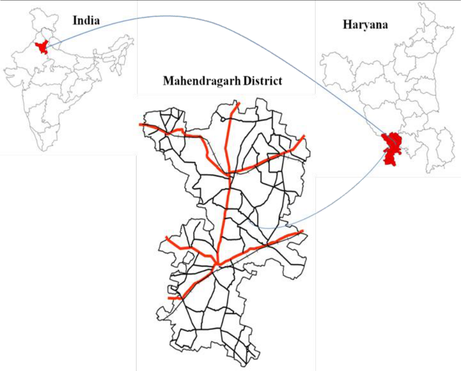 Figure 1
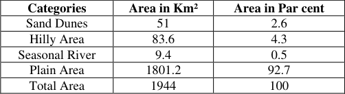 Table 1
 Table 2
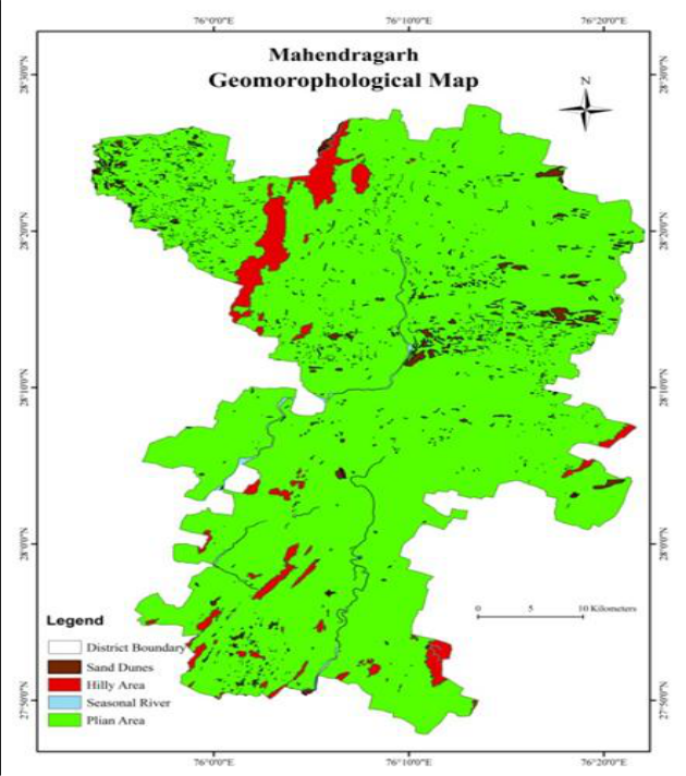 Figure 2
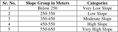 Table 3
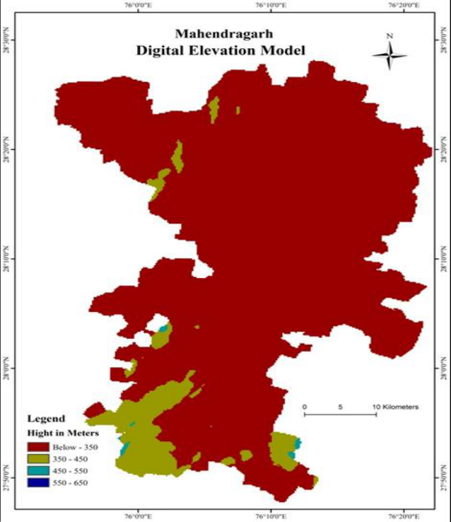 Figure 3
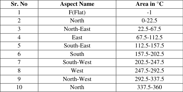 Table 4
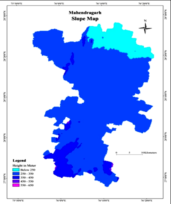 Figure 4
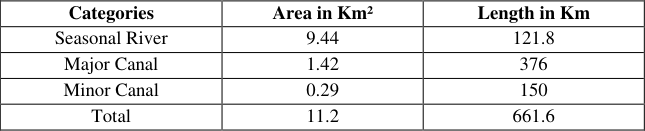 Table 5
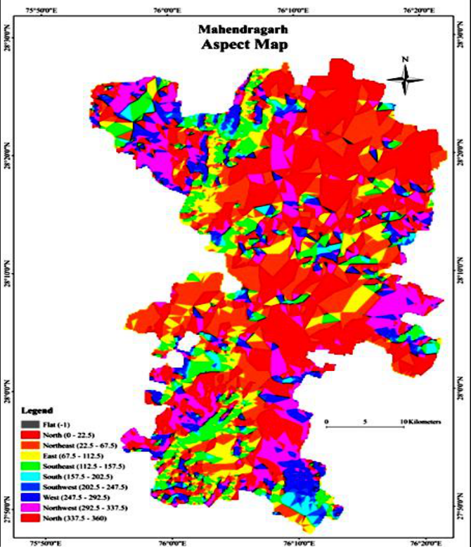 Figure 5
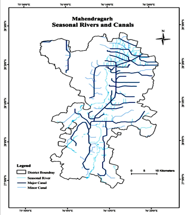 Figure 6
Introduction
Geomorphology is defined as the science of landforms with an emphasis on their origin, evolution, from and distribution across the physical landscape. The geomorphological analysis involves delineation of distinct units from satellite data and classification of these units based on there nature of genesis, extent and their processes (Reddy et al., 2002) [9] . Geomorphology is important for the understanding of Earth surface processes, geochronology, natural resources, natural hazards and landscape evolution. It involves the partition of the particular area based on morphology, genetics, composition, structure, land cover, soil, ecology as well as landforms. Geomorphological studies in India has received great fill up by the works of geologist and geographers. There has been an emphasis on various aspects of geomorphology from regional to coastal, structural, fluvial, climatic and Applied Geomorphology (Sharma HS, 1982) [10] . Most of the surface area of Haryana is constituted of the Late Quaternary deposits. The structural and denudational hills can also be subdivided into, the West North West-East North East (WNW-ENE) trending series of parallel ridges of Siwalik rocks in the northern part and widely spaced North North East-South South West (NNE-SSW) ranges and isolated hills of Delhi super group in southern part (Geology and Mineral Resources of Haryana, 2012) [6] . The Mahendragarh district has dry-land topography as there are present sandy plain inland stream shifting sand dune and devoid of vegetation dissected upland tract fixed or fossil sand dune and rarely denuded barren rocky hills ranges which is a group of terrain whose features truly connected with semi-arid to arid environment. The two well-known sandy plain are present in Mahendragarh district. The first sandy plain is generally present in western and eastern parts of Aravali ranges mostly found in Mahendragarh district. The natural drainage system of district consist of mainly three seasonal streams, the Sahibi, the Dohan and the Krishnawati seasonal streams. Remote Sensing identifies the locations of geomorphological features and natural resource. The advancement in Remote Sensing and GIS has revolutionized the field of Geomorphology. These Remote Sensing and GIS techniques allowing geomorphologists to identify vegetation and geomorphological patterns present within the imagery.
Thus, the GIS environment can be used to add further detection process through visualisation, analysis and modelling techniques and to correct Remote Sensing imagery for topographic effects (Smith RG, et al., 1996) [12] .
Study Area
Mahendragarh district, located in South-Western part of Haryana and the geographically area covered is 1944 Km². It is located between 2748' N to 2828' N latitudes and 7554' E to 7622' E longitudes. It is surrounded by Bhiwani district in North, Rewari district in East, Alwar, Jaipur and Sikar in South and in West by Sikar and Jhunjhunu districts of Rajasthan State. Landscape of the district comprises of undulating plains, sand dunes and baring rocky surface. Topography of the district is peculiar. The residuals of the Aravali are spreading in the district giving the rocky outlook. Climate of the district is hot and semi-arid in nature. The location map of the study area is shown in Figure 1.
Data Sources and Methodology
Data in this study are used digital topographic maps Survey of India (SOI). We have taken Topo-sheets no 43V_15, H 43V_16, H 43W_3, H 43W_4, H 43W_7, H 43W_8, G 43_D13 and G 43 E_1 of 2007 with a 1:50000 scale. A mosaic has created from all toposheet using Erdas 9.0 software. Then, contours are digitized with the help of Arc GIS 9.3 software. These contours are utilised for the study of Geomorphology of Mahendragarh district. Digital Elevation Model was prepared in Arc GIS 9.3 software using topo-sheets to raster tool with the help of contours. Slope map has been prepared by using Digital Elevation Model (DEM) similarly aspect map is also prepared by using Digital Elevation Model (DEM). With the help of topo-sheets, we digitized the canal distribution and seasonal rivers.
Geomorphology
Geomorphologically, the area of Mahendragarh district can be divided into four different geomorphic regions characterized by different geomorphic elements and relief characteristics. These are Plain area, Sand dunes, Hilly area and Seasonal Rivers. This is shown in Figure 2 and explained with the help of Table 1. S and dunes is one of category or class having an area of 51 Km² and cover about 26 per cent of total area. Sand dunes are mostly present in North-West and South-West and near Mahendragarh block of Mahendragarh district. The third category is high category relief zone height varies from 450 to 550 meters. High relief zone is present in Nangal Choudhary block, near Dhosi hills, lower part of Satnali block. The fourth category is very high category relief zone and its height varies between 550 to 650 meters. This relief zone lies in very few part of Sorth-West as a continuous range of the study area.
| Categories | Area in Km² | Area in Par cent |
|---|---|---|
| Sand Dunes | 51 | 2.6 |
| Hilly Area | 83.6 | 4.3 |
| Seasonal River | 9.4 | 0.5 |
| Plain Area | 1801.2 | 92.7 |
| Total Area | 1944 | 100 |
Table text extracted from the original PDF; superscript letters are shown inline. The original table image is below.
View original table image
Slope
The term slope has two commonly used meanings, one referring to the angle of inclination of the surface, express in degrees or a percent, and the other is the inclined surface itself. Slope displays the grade of steepness expressed in degree or as per cent slope (Cires J, et al., 1994) [2] . DEM slope is generated for a fixed slope length which is related to the sampling intervals. The study of slope is not only of academic, but also of practical, significance. Slope map for the Mahendragarh has been prepared by using Digital Elevation Model (DEM).
Aspect
Aspect identifies the down-slope direction. Aspect images may enhance landforms such as fluvial network, alluvial fans, faceted fault related scarps etc. (Cires J, et al., 1994) [2] . Aspect usually known to the horizontal direction to which a mountain slope faces. 4. Mahendragarh distributaries of the Jawaharlal Nehru canal command system makes the chief canal network in the region. The natural slope of surface is from South to North in the canal command area but the direction of flow of water in canal is from North to South by lifting systems. This canal system is better only in the Mahendragarh block. These are the main source of drinking, irrigation and recharge the ground water. Seasonal rivers and canal distribution of Mahendragarh district is shown in Figure 6, and described in Table 5. 6 The seasonal river in Mahendragarh district covers 9.44 Km² area and length of 121.8 Km. The major canals are also made for distribution of water. Major canal system covers area of 1.42 Km² and length of 376 Km whereas minor canals have area of 0.29 Km² and length of 150 Km.
| Categories | Area in Km² | Length in Km |
|---|---|---|
| Seasonal River | 9.44 | 121.8 |
| Major Canal | 1.42 | 376 |
| Minor Canal | 0.29 | 150 |
| Total | 11.2 | 661.6 |
Table text extracted from the original PDF; superscript letters are shown inline. The original table image is below.
View original table image
Figures and tables from the paper
| Sr. No. | Altitudinal Zone in Meters | Category of Relief Zones |
|---|---|---|
| 1 | Below 350 | Low |
| 2 | 350-450 | Medium |
| 3 | 450-550 | High |
| 4 | 550-650 | Very High |
Table text extracted from the original PDF; superscript letters are shown inline. The original table image is below.
View original table image
| Sr. No. | Slope Group in Meters | Categories |
|---|---|---|
| 1 | Below 250 | Very Low Slope |
| 2 | 250-350 | Low Slope |
| 3 | 350-450 | Moderate Slope |
| 4 | 450-550 | High Slope |
| 5 | 550-650 | Very High Slope |
Table text extracted from the original PDF; superscript letters are shown inline. The original table image is below.
View original table image
| Sr. No | Aspect Name | Area in °C |
|---|---|---|
| 1 | F(Flat) | -1 |
| 2 | North | 0-22.5 |
| 3 | North-East | 22.5-67.5 |
| 4 | East | 67.5-112.5 |
| 5 | South-East | 112.5-157.5 |
| 6 | South | 157.5-202.5 |
| 7 | South-West | 202.5-247.5 |
| 8 | West | 247.5-292.5 |
| 9 | North-West | 292.5-337.5 |
| 10 | North | 337.5-360 |
Table text extracted from the original PDF; superscript letters are shown inline. The original table image is below.
View original table image
References
13 in the original paper- Chorley R, Schumm SA, Sugden DE. Geomorphic processes and landforms. 1 st Ed. London: Methuen & Co. Ltd; 1984.
- Cires J, Marturia J, Paz de A, Casanovas J, Llopart A. Digital elevation models; 1994.
- A useful tool for geological mapping-examples from Catalonia. In: Computer methods in the geosciences. Elsevier Science Ltd; 1994.
- Dayal P. A textbook of geomorphology. 6 th Ed. New Delhi: Rajesh Publications; 2011.
- Gibson P, Power C. Introductory remote sensing: digital image processing and applications. 1st ed. London: Routledge; 2000.
- Goudie A, Viles H. Landscapes and geomorphology: a very short introduction. 1 st Ed. New York: Oxford University Press; 2010.
- Geological Survey of India. Geology and mineral resources of Haryana. Miscellaneous Publication No. 30, Part XVIII. 2nd rev ed. Government of India; 2012.
- Singh J, Kumar S, Bhoria S. Analysis of water resources in Mahendragarh District. APJEM Arth Prabhand: J Econ Manag. 2013;2(9).
- Mehra G, Rajeshwari. GIS-based delineation of microwatershed and its applications: Mahendragarh District, Haryana. J Hum Ecol. 2012;38(2).
- Reddy OBI GP, Maji KA, Srinivas VC, Velayutham M. Geomorphological analysis for inventory of degraded lands in a basaltic river basin using remote sensing and GIS. J Indian Soc Remote Sens. 2002;30(1-2).
- Sharma SH. Perspectives in geomorphology: essays on Indian geomorphology. 1 st Ed. New Delhi: Concept Publishing Company; 1982.
- Smith RG. Integrating remote sensing, GPS and GIS for geomorphological mapping in mountain environments. In: Proceedings of the 4 th International Symposium on High Mountain Remote Sensing Cartography, KarlstadKiruna-Tromsø; 1996.
- Zhou Q, Liu X. Analysis of errors of derived slope and aspect related to DEM data properties. Comput Geosci; 2004, p. 30.