
Research article · 2025 · Full text
International Journal of Agriculture and NutritionAssessment of natural radioactivity in agricultural surface soil samples in Kufa
Volume 7(12) · Pages 07–10 · DOI: 10.33545/26646064.2025.v7.i12a.318 ↗
Research areasRadioactivity and Radon MeasurementsRadioactive contamination and transferNuclear and radioactivity studies
Abstract
Author-writtenThis article investigates the natural radioactivity levels of agricultural surface soils of the city of Kufa, Najaf Governorate, Iraq. Mainly three naturally occurring radionuclides, which are responsible for external and internal radiation exposure ²³⁸U, ²³²Th, and ⁴⁰K were considered. The reason of monitoring these radionuclides is that it can be transported from soil to crop and finally to the man as well as animal food chain which results in increased chronic exposure. A total of fifteen soil samples were sampled from the agricultural sites to account for variations in land use, irrigation and soil texture. We prepared samples by air-drying them, sieved and homogenized for later stored in sealed containers to reach secular equilibrium prior to measurement. Gamma-ray spectrometry with a NaI(Tl) detector was used to measure (or assess) the concentrations of radionuclides. The measured concentrations of U-238, Th-232 and K-40 were found to vary between 22.8 and 28.4Bq/kg, 17.5 and 22.7Bq/kg and 309 and 380Bq/kg respectively from the same results. All values were less than the global safety levels of U-238, 33Bq/kg, Th-232, 45Bq/kg, and K-40, 420Bq/kg, respectively. Small differences were explained by the nature of the soil, minerals and agricultural practices which are specific for each region. These results confirm that the natural radioactivity in the agricultural soils of Kufa does not reach dangerous levels and will not have a significant radiological impact on human health and crops. These results serve as a baseline for broader environmental monitoring and will help to promote sustainable land use of farmland in that region.
Summary
Source-checkedPlain-language reading of the full paper, prepared with AI and checked against the text. Each point links to the authors' own words.
Why it matters
- Soil natural radioactivity is driven by primordial radionuclides, specifically uranium-238, thorium-232, and potassium-40, which have persisted since the Earth's crust formed. View evidence ↗
- Monitoring these radionuclides is necessary because they can move from the soil into crops and then into the human and animal food chains, leading to chronic radiation exposure. View evidence ↗
- The concentration and occurrence of natural radionuclides vary by region due to differences in climate, soil-forming processes, mineral composition, and geological structure. View evidence ↗
The question
- The study aims to investigate the levels of natural radioactivity in the agricultural surface soils of Kufa, located in the Najaf Governorate of Iraq. View evidence ↗
- The research seeks to establish a baseline database to better understand exposure risks and support sustainable land management in Kufa. View evidence ↗
What they did
- Fifteen soil samples were collected from agricultural sites, selected to represent various soil textures, irrigation methods, and land uses. View evidence ↗
- Samples were sealed and stored for 21 to 30 days to ensure secular equilibrium between radium-226 and its short-lived progeny before measurement. View evidence ↗
- The concentrations of radionuclides were measured using gamma-ray spectrometry equipped with a NaI(Tl) detector. View evidence ↗
- To reduce background interference, the detector was placed inside a lead shield with a thickness of 10 to 15 cm. View evidence ↗
What they found
- The measured activity concentrations ranged from 22.8 to 28.4 Bq/kg for U-238, 17.5 to 22.7 Bq/kg for Th-232, and 309 to 380 Bq/kg for K-40. View evidence ↗
- All measured values were below the global safety limits of 33 Bq/kg for U-238, 45 Bq/kg for Th-232, and 420 Bq/kg for K-40. View evidence ↗
- Higher thorium concentrations in some samples were attributed to clay-rich fractions, while potassium variability was linked to both mineralogy and the use of fertilizers. View evidence ↗
What it means
- The authors conclude that natural radioactivity in Kufa's agricultural soils is not at dangerous levels and will not significantly impact crops or human health. View evidence ↗
- The findings establish a basis for future environmental monitoring and indicate that the soils are safe for human and agricultural use. View evidence ↗
Visual summary
3 visualsIllustrations explain the paper; charts are replotted from the paper's own table values.
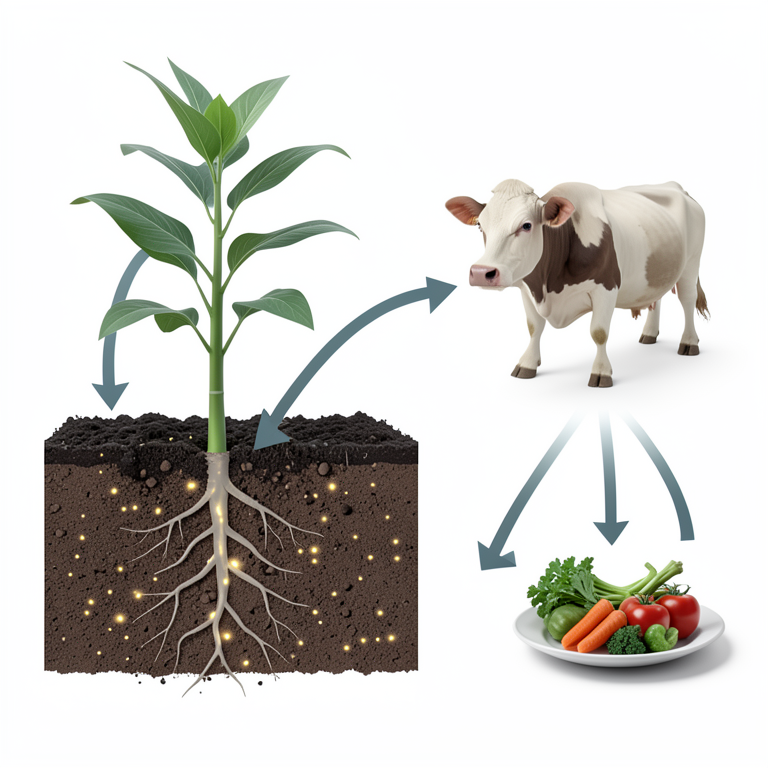
Radionuclide Transfer Pathway
AI-generated conceptual illustration (Agricultural surface soil and crops in Kufa). It explains the idea and does not show study data.
View source evidence ↗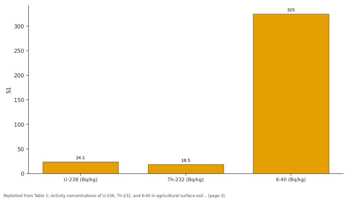
S1: U-238 (Bq/kg) vs Th-232 (Bq/kg) vs K-40 (Bq/kg)
Replotted from Table 1 (page 3) of the original paper. Every bar is the paper's own table value.
View source evidence ↗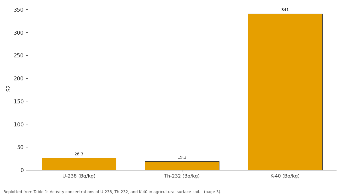
S2: U-238 (Bq/kg) vs Th-232 (Bq/kg) vs K-40 (Bq/kg)
Replotted from Table 1 (page 3) of the original paper. Every bar is the paper's own table value.
View source evidence ↗Figures & tables
From the original paper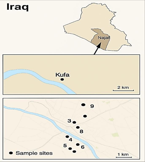 Figure 1
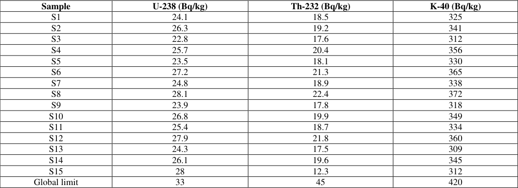 Table 1
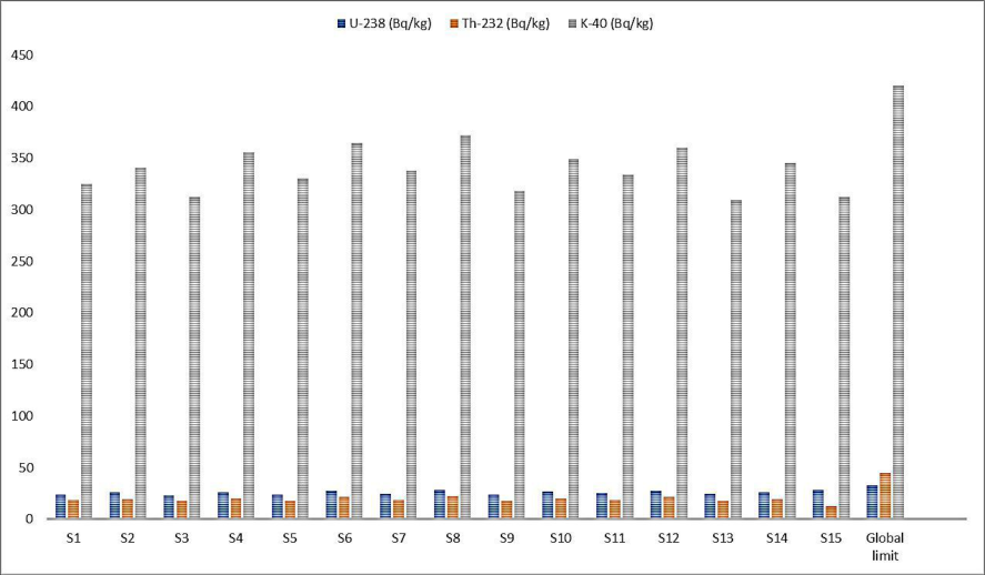 Figure 2
Introduction
Natural radioactivity of soil is caused by the presence of primordial radionuclide of uranium-238 (²³⁸U), thorium-232 (²³²Th) and potassium-40 (⁴⁰K) which have not been spent since the formation of the Earth's crust. These radionuclides represent a major source of external gamma radiation as well as internal exposure from ingestion or inhalation routes (UNSCEAR 2008 [1] ). Due to the ability to transfer from soil to plants whereby humans and livestock can also be exposed to long-term radiation via the food chain, the monitoring of radionuclides in agricultural soils is vital (IAEA, 2010) [2] . Since the geological structure as well as mineral composition, climate and soil-forming processes differ greatly, natural radionuclides differ significantly in both their occurrence and activity concentration from region to region. These differences can be seen clearly in studies in various countries. For instance, high background radiation area of the Kerala state in India, which is characterized by monazite-rich sands, showed elevated thorium levels (Nair et al, [3] ), whereas much lower values, associated with the sedimentary formations, are found in the central Europe (Cinelli et al, [4] ). At Ramsar in Iran, abnormally high natural radioactivity has been reported (Ghiassi-Nejad et al., 2002) [5] .The compilation of data from these international studies will also provide comparative baseline data for levels of soil radioactivity in other parts of the world. Environmental radioactivity studies in Iraq show relatively low levels of radionuclides in areas impacted by Tigris and Euphrates river sediments, whereas some areas are characterized by higher levels of radioactivity as a result of geological or anthropogenic factors (Al-Kareem et al., 2016) [6] . Kufa is an agricultural region which is highly reliant on the Euphrates river for irrigating its land; the region is also part of the Najaf Governorate. Surface soil of radish, an important crop in agriculture, has received little research on natural radioactivity, especially those soils used for food production. NaI(Tl) gamma-ray spectrometry is one of the most frequently used gamma detectors for the assessment of natural radionuclides in environmental samples. This method is expected to generate accurate results for the isotopes of ²³⁸U, ²³²Th and ⁴⁰K and is recognized standard method for environmental monitoring (Knoll, 2010) [7] . Determining natural radioactivity in the agricultural soils of Kufa is a major requirement to a fuller baseline database and to understand the risk of exposure as well as sustainable land management. These outputs will be a part of the radiation monitoring programs and will aid in the protection of the community dependent on these farmlands.
Study Area
Kufa is situated in Iraq's central Najaf Governorate, some 170 km south of Baghdad. The city is located on the eastern edge of the banks of the Euphrates River and is the most agro-ecological center in the world. The region has irrigated farmland which helps grow wheat, barley, vegetables, and palm orchards. Kufa soil is mainly alluvial soil, as it is produced from deposition material over the years by the Euphrates River, which makes it fertile soil suitable for planting. This research is concerned with fifteen surface soil sampling sites on the agricultural belt of Kufa. We selected these sites to encompass a range of land use, irrigation sources, and soil texture. Detailed sampling locations (latitude and longitude) were recorded to the nearest 0.1m using a high-accuracy GPS receiver. The geographic location of these sampling locations is mapped to capture spatial coverage of the core agricultural region, which means that collected samples represent the radiological properties for soils that directly contribute to local food production.
Laboratory sample preparation
Samples are air-dried in a fume cupboard at room temperature to constant weight. Subsequently, if necessary for moisture content determination, oven-dry at 105 °C for a short time. Use consistent protocol across samples. [8,9] Remove stones, roots, and large organic fragments. Crush and grind to pass a 2 mm sieve. For gamma spectrometry finer grinding (≤1 mm) improves homogeneity. [9,3] Weigh a known mass (typical 300-500 g) into counting containers. Use standardized geometry (e.g., 1 L Marinelli beaker or cylindrical container) for all samples and standards. Record exact mass. [3,10] Seal containers hermetically to prevent radon loss. Store sealed samples for 21-30 days to allow secular equilibrium between 226Ra and its short-lived progeny (important when measuring U-series by gamma peaks). Many studies use 30 days; one-month storage is common. [10,11]
Detector, shielding and counting geometry
Detector: NaI (Tl) scintillation detector (commonly 3″×3″ or larger). NaI (Tl) offers good sensitivity and lower cost but lower energy resolution than HPGe. Use when NaI is the chosen system. [11,13] Shielding: place detector inside lead shield, typically 10-15 cm lead thickness, to reduce background. Use a background measurement with an empty but sealed geometry-matched container. [12,11] Geometry: maintain identical sample-to-detector geometry for samples and calibration standards. Use the same container type and orientation. [13]
Results and discussion
In this study, fifteen agricultural surface-soil samples were collected from different locations in Kufa to assess the natural radioactivity levels. The samples were prepared and measured using a NaI (Tl) gamma spectrometer, focusing on the activity concentrations of uranium-238 (U-238), thorium-232 (Th-232), and potassium-40 (K-40). These radionuclides were selected because they are the main contributors to natural radioactivity in soils and are commonly used to evaluate radiological safety in agricultural areas. The values measured for each of the samples were then compared with the international reference values declared by UNSCEAR to confirm that they are within the established limits regarding human exposure and agricultural use. The results suggest that the soils of Kufa are not radiologically hazardous, having simply natural activity concentrations in typical ranges for sedimentary soils, and hence provides a reference for future environmental surveillance in the area. The radioactivity levels of U-238 (22.8-28.4 Bq/kg), Th-232 (17.5-22.7 Bq/kg), and K-40 (309-380 Bq/kg) were all lower than the maximum limits recommended by international organizations. Although uranium levels among the samples differed slightly, this is likely representative of natural variability of soil composition and mineral content, particularly the granitic bedrock from which the soil was formed. Activated concentrations of thorium were higher in some samples due to clay-rich fractions, whereas potassium variability had both mineralogical and agricultural connotations linked to fertilizer application. Radiologically, the measured radionuclides are found to be within natural concentrations and so agricultural soils of Kufa do not represent a risk to human health or agricultural activities [14,15] .
Conclusion
The assessment of natural radioactivity in agricultural surface-soil samples from Kufa shows that the activity concentrations of U-238, Th-232, and K-40 range within safe limits are recommended by international standards. Uranium levels varied between 22.8 and 28.4 Bq/kg, thorium between 17.5 and 22.7 Bq/kg, and potassium between 309 and 380 Bq/kg. The absence of the parameters indicates that the soils are not radiologically contaminated and that radiological risk does not exist. The results lay the foundation for environmental monitoring and also indicate that the agricultural soils of Kufa are safe for agricultural and human use without significant radiation risk.
Figures and tables from the paper
| Sample | U-238 (Bq/kg) | Th-232 (Bq/kg) | K-40 (Bq/kg) |
|---|---|---|---|
| S1 | 24.1 | 18.5 | 325 |
| S2 | 26.3 | 19.2 | 341 |
| S3 | 22.8 | 17.6 | 312 |
| S4 | 25.7 | 20.4 | 356 |
| S5 | 23.5 | 18.1 | 330 |
| S6 | 27.2 | 21.3 | 365 |
| S7 | 24.8 | 18.9 | 338 |
| S8 | 28.1 | 22.4 | 372 |
| S9 | 23.9 | 17.8 | 318 |
| S10 | 26.8 | 19.9 | 349 |
| S11 | 25.4 | 18.7 | 334 |
| S12 | 27.9 | 21.8 | 360 |
| S13 | 24.3 | 17.5 | 309 |
| S14 | 26.1 | 19.6 | 345 |
| S15 | 28 | 12.3 | 312 |
| Global limit | 33 | 45 | 420 |
Table text extracted from the original PDF; superscript letters are shown inline. The original table image is below.
View original table image
References
9 in the original paper- The United Nations Scientific Committee on the Effects of Atomic Radiation. Sources and effects of ionizing radiation. UNSCEAR; 2008.
- International Atomic Energy Agency. Radiation protection and safety of radiation sources. IAEA; 2010.
- Nair RN, et al. Natural background radiation in the high-background-radiation area of Kerala. 2009. International Journal of Agriculture and Nutrition https://www.agriculturejournal.net
- Cinelli G, et al. Soil radioactivity atlas of Europe. J Environ Radioact. 2015; 150:594-601.
- Ghiassi-Nejad M, et al. Very high background radiation areas of Ramsar. Health Phys. 2002;82(1):87-93.
- Al-Kareem HS, et al. Natural radioactivity levels in Iraqi soils. Environ Earth Sci. 2016;75(2):1-10.
- Knoll GF. Radiation detection and measurement. John Wiley & Sons; 2010.
- Ahmed RS, Mohammed RS, Abdaljalil RO. The activity concentrations and radium equivalent activity in soil samples collected from the eastern part of Basrah Governorate in Southern Iraq. Int J Anal Chem. 2018;2018:2541020.
- Nafae TM, Hasan HA, Mohammed AN, Hashim AF. Radiation hazard assessment by measuring of soil radioactivity levels in Al Anbar (Al Fallujah District) and Wasit Governorate in Iraq. Int J High Energy Phys. 2018;5(1):5-11.