
Research article · 2025 · Full text
International Journal of Geography Geology and EnvironmentApplication of selected engineering geological methods for landslide hazard assessment in the Klisan/Sartka area, western Sulaymaniyah
Volume 7(10) · Pages 17–24 · DOI: 10.22271/27067483.2025.v7.i10a.424 ↗
Research areasLandslides and related hazards
Abstract
Author-writtenThe study of slope stability in the Sartka region, a significant tourist destination in the Dukan district of the Kurdistan Region of Iraq, is crucial due to its ongoing urban expansion. The landslide rock falls, and ground failures have considerably affected family camps, tourist roads, and recently built residential areas on slopes affected by cutting and filling operations, exposing them to landslide risks. This study focuses on assessing the risk of landslides in mountainous regions using the Landslide Possibility Index method. The method assesses factors that affect slope stability and identifies areas of risk. It improves predictions about cut slopes in mountainous roads. The study identifies the predominant type of landslides and classifies sites based on factors like slope angle, fracture degree, weathering degree, discontinuity gradient, spacing, orientation of discontinuities, vegetation cover, water infiltration, and previous landslides. In addition to the magnitude and range of the dangers that slopes are subject to, five stations were selected, information was gathered, and ten LPI system parameters were measured in the field. The results indicate varying degrees of risk for different sections, ranging from moderate to very high. The slopes in the study area are characterized by a high degree of fracturing and weathering, with very minimal spacing between the joints, and a favorable orientation of these joints in relation to the bedding plane dip. as well as the marl layers of the Kometan and Tanjero formations increase the vulnerability of rock slopes to weathering and erosion, leading to more slope failures. The research highlights the need for preventative measures and engineering solutions to protect structures and ensure public safety in the area.
Summary
Source-checkedPlain-language reading of the full paper, prepared with AI and checked against the text. Each point links to the authors' own words.
Why it matters
- Slope stability analysis in the Sartka region of Iraq is critical because the area is a major tourist destination experiencing continuous urban growth. View evidence ↗
- Landslides and ground failures in the area have already impacted residential zones, tourist roads, and family camps, particularly where slopes were modified by cutting and filling. View evidence ↗
- The presence of marl layers within the Tanjero and Kometan formations makes rock slopes more susceptible to erosion and weathering, which increases the frequency of failures. View evidence ↗
The question
- The research aims to assess landslide risks in mountainous regions by applying the Landslide Possibility Index (LPI) method. View evidence ↗
What they did
- The researchers used an integrated approach combining satellite imagery analysis (Google Earth and ArcMap GIS) with field observations to identify unstable slopes. View evidence ↗
- The study involved gathering data and measuring ten LPI system parameters across five selected field stations. View evidence ↗
- The LPI method quantitatively assesses risk based on ten factors, including slope, weathering, rock fracturing, vegetation cover, and water seepage. View evidence ↗
What they found
- Station 1 was classified as high risk (Category V) with a total LPI score of 25. View evidence ↗
- Station 2 was identified as the most stable site, falling into the moderate risk zone (Category IV) with a score of 18. View evidence ↗
- Station 3 (referred to as the second segment in the summary) was classified as high risk (Category V) with a score of 22. View evidence ↗
- High-risk sites were characterized by severe weathering, high fracturing, and joint spacing of less than 0.05 m. View evidence ↗
What it means
- To maintain stability, the authors state that cutting and filling operations on these slopes must be prohibited. View evidence ↗
Visual summary
1 visualsIllustrations explain the paper; they do not show study data.
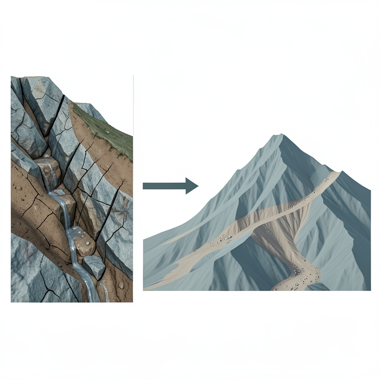
LPI Factor Framework
AI-generated conceptual illustration (a mountainous landscape in the Klisan/Sartka area with rocky slopes and sparse vegetation). It explains the idea and does not show study data.
View source evidence ↗Figures & tables
From the original paper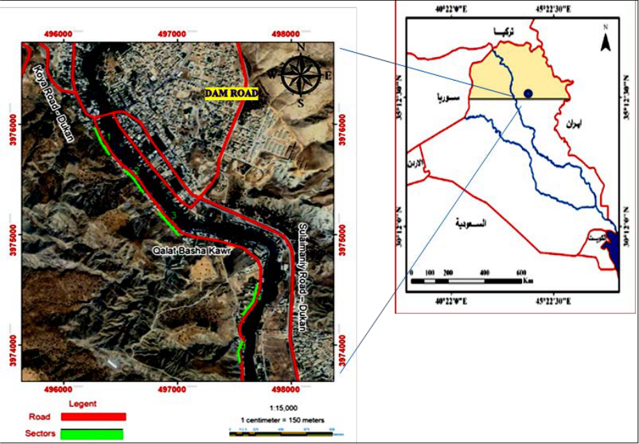 Figure 1
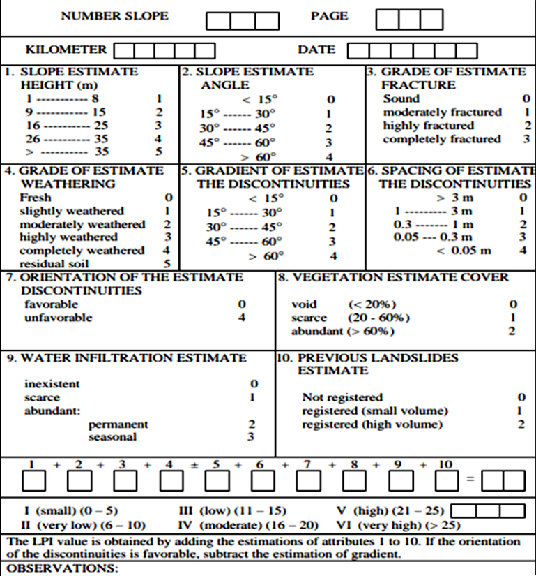 Figure 2
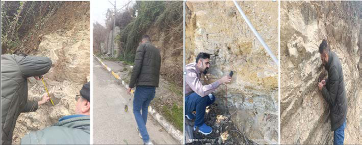 Figure 3
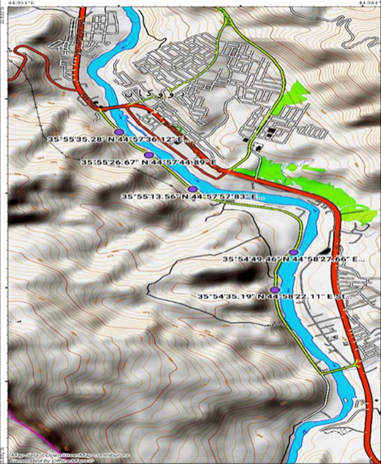 Figure 3
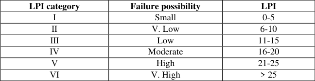 Table 1
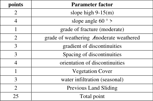 Table 2
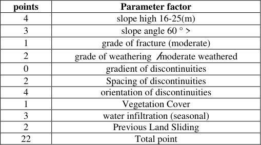 Table 3
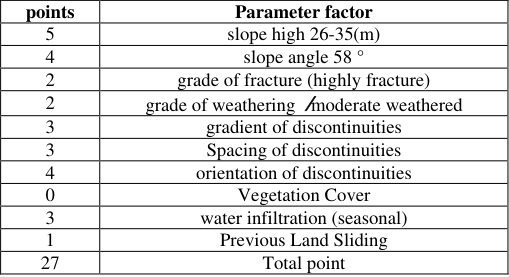 Table 4
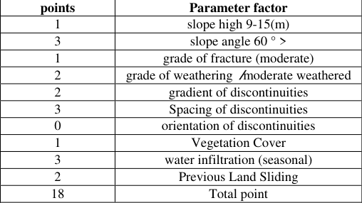 Table 3
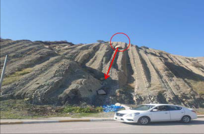 Figure 4
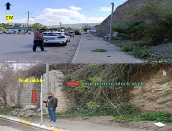 Figure 3A
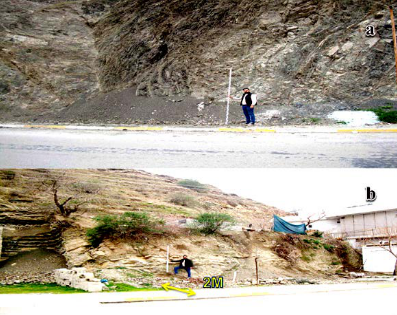 Figure 5A
Introduction
Slope stability is a concept that represents the ability of a slope to maintain its shape and structural integrity without collapsing or sliding. This stability depends on the balance of forces acting on the slope, including the weight of soil and rocks, gravity, and environmental factors such as moisture and seismic vibrations. (Ramesh, 2021) [10] , (Sharma & Ahirwar, 2024) [11] . The study area represents one of the most important tourist destinations overlooking the banks of the Dukan River, specifically the Lesser Zab. The selected stretch extends approximately 3 kilometers along the liser zab river course and attracts a large number of tourists throughout the year, resulting in heavy traffic and pedestrian congestion. Additionally, numerous buildings have been constructed on the slope through cut-and-fill techniques, as was observed during the fieldwork. This factor increases the likelihood of landslides. To assess the risks of these landslides, the Landslide Possibility Index (LPI), developed by Bejerman (1994) [2] , was used to evaluate slope stability. This system was chosen for its ease of field application, as it provides a detailed and accurate study of the entire area, allowing for the assessment of the engineering and structural characteristics of the slopes. The stability of cut slopes on highways is crucial, as even minor failures can lead to severe financial and human losses. A detailed analysis of failure mechanisms is required both before and after cutting and filling (Kainthola et al., 2013) [6] . While physical and chemical weathering of bedrock produces fragmented particles that accumulate on the surface, sufficient erosion processes remove them. Gravity causes these particles to move down the slope and accumulate as deposits (Turner, 1996) [14] . Factor is an important element to consider in landslide modeling. Among the various impacts of plants, root reinforcement is widely recognized as one of the most significant factors for slope stability.
However, in layers with numerous fractures, its effect can sometimes be opposite, as it increases the spacing between rock layers (Masi et al., 2021) [9] . The Landslide Possibility Index (LPI) method, developed by Bejerman (1994) [2] , includes ten key factors: slope steepness, angle, fracture degree, weathering extent, discontinuities, spacing between layers, layer orientation, vegetation cover, and previous landslides. The Dokan area holds a significant geographic position as a junction of major roads connecting Sulaymaniyah to nearby regions. It is also home to the Dokan Dam and Basin, which are notable for their important geological and structural characteristics. Dokan lies on the southwestern limb of the Kosret Anticline. (Zarraq, 2021) [16] . In 2024, a road risk assessment was conducted along the main road crossing the Qiwan Anticline, situated approximately 20 km north of Sulaymaniyah Governorate. The study utilized the Landslide Possibility Index (LPI) and the Rockfall Hazard Rating System (RHRS) to evaluate potential geohazards. (Zarraq, 2021) [16] . The roads in the northern part of Iraq are primarily mountainous, characterized by steep ascents and descents. Haphazard road cuts have led to instability issues and/or potential areas prone to sliding. Satellite images of the road and all those potential areas were checked in the field, and a study was conducted. (Sissakian et al., n.d.)
Geologic settings
The study area is situated in a highly folded zone characterized by numerous high-amplitude, closely spaced, tight, and overturned folds of varying geometries and dimensions. The landforms, characterized by erosionresistant Cretaceous rock formations, have significant structural features, manifesting in the topography as elevated, rocky anticlinal mountains interspersed with narrow, deep synclinal valleys. The study area is located in the west of Dukan, along the southwestern part of the Dukan stream, near the Dukan-Qashquli road, northwest of Sulaimaniyah city, approximately 57 km northeast of the Kurdistan Region, Iraq. Geologically, it is located within the Tanjero Formation along the main road (Figure 1). In the Surdash anticline, the formation is divided into two members: Lower Member (300 m), which consists of alternation of sandstone, mudstone, shale, conglomerate, claystone, and sandy limestone. Upper Member (659 m) consists of alternation of sandstone, mudstone, and silty claystone, dominated by mudstone and silty claystone (Al-Shwialy et al., 2011) [1] .
Tectonics and Structural Geology
The road lies in the high folded zone, marked by tightly spaced, broad folds and prominent landforms shaped by erosion-resistant Cretaceous rocks (Fouad, 2019) [4] . Within the research region, four locations were chosen, all of which were at different elevations and lined up along the Dokan River's path. At the first and second stations, the dip direction is oriented in opposition to the slope direction, and the dip angle at each station varies roughly between 42° and 65°.
Materials and methods
This study used an integrated approach to identify unstable slopes along the Sartka-Qashqoli route by analyzing satellite pictures (such as those from Google Earth and ArcMap GIS). Following this, fieldwork was conducted to record visual evidence and signs of instability. Additionally, a modified checklist was used to classify slope characteristics (Beijerman, 1994) This area was chosen because it is one of the most prominent tourist spots that gets crowded with vehicles and visitors during the tourist season. Additionally, many houses, buildings, and farms have been constructed on those slopes. The fieldwork tools were as shown in Fig. 3, which include a distance measuring wheel, measuring tape, and GPS, and the locations of the study sites with their coordinates are indicated on the topographic map as shown in Fig2. App). Both the slope elevation and height measurement ruler were determined. Data were recorded for the slope elevation, the length of the slope face, weathering degree, spacing between discontinuities and their arrangement, vegetation cover, and previous landslides in the area, as shown in Fig. 2. According to Beijerman (1994), we apply LPI on each station. Where the slope length and spacing as shown in Fig., height, degree of inclination, and its directions were measured, the degree of fractures and weathering were determined, and then the percentage of vegetation cover on those slopes, the width of the pavement, the degree of rainwater infiltration, and the impact of weather factors during the wet seasons were assessed. Surveys were conducted in both the wet and dry seasons and compared, and the percentage of the impact of erosion factors and cutting processes on those slopes was determined.
This is the vertical distance from the bottom of a slope to the top of the slope hill, measured in meters oe. The steepness of a slope has a direct effect on how strong the rock is against sliding, so it's an important factor in studies about earth movements, like predicting landslides (Zhang et al., 2018 [17] ; Wang et al., 2019) [18] .
Slope angle:
This is how the steep a slope is, measured in degrees from a flat horizontal line.
Grade of fracture:
When rocks crack, it's because the stress inside them becomes too much for the rock to handle. This changes the rock from bending and flowing to sliding against itself. These cracks usually happen in narrow zones where the rock grains move differently, and the way they move depends on how fast or slow the stress is applied. (Liu et al., 2020) [8] .
Grade of weathering:
This refers to how much a rock or soil has changed over time due to physical, chemical, or biological processes.
Gradient of discontinuities:
angle of inclination of repeated, uniform discontinuities (e.g., joints, bedding planes, fractures) within the slope, if present.
Spacing of discontinuities:
It refers to the uniform attitude, or perpendicular distances between the discontinuities, which, together with the stratification levels, define the sizes of the failed or potentially failing rock masses. (Tokmachy & Mohammad, 2024) [19] . 7. The distance between adjacent discontinuities is measured along a given plane or direction, usually in meters or centimeters. The spacing distribution of natural joints or fractures in rock masses affects the rock mass's deformability, strength, and transport properties, depending on the size, spatial distribution, and deformability of these features (Stavropoulou et al., 2021) [13] .
Orientation of discontinuities:
If the slope and the direction a rock surface is tilted don't help start a landslide, it's a good condition. But if the tilted and crossed joint with the other joint set makes it easier for a landslide to happen, it's a bad condition.
Vegetation Cover:
Vegetation cover is the plants growing on the land. prevent erosion, help to hold the soil together, and reduce the chance of landslides. Sometimes making a space between the joints is more than enough to increase the hazard.
Water Infiltration:
Water infiltration is when water moves into the soil.
11.
If too much water enters the ground, it can weaken the soil and increase the risk of erosion or a landslide.
12. Previous Landslides: Previous landslides refer to past ground shifts or collapses, highlighting areas with a higher risk of future landslides. Based on the total points of station one as showed in Table (2), the result demonstrate that the first district falls within the (fifth category) of risk according to Table (1), which is relatively high and requires a warning tape to reduce the risk of landslides or to warn people against building houses on those slopes. Through Table (2) of station tow the total points obtained in the landslide probability index classification system, the finding indicate that the second district falls within the moderate risk zone, specifically at the fourth level of the risk categories classification. This is due to the narrow width of the pavement and the steepness of the slope. The slope does not currently pose a significant risk, but it could become unstable if exposed to factors such as heavy rainfall or earthquakes. It is recommended to monitor it continuously and take preventive measures such as improving drainage and stabilizing the soil. The Table (3) summarizes that the total points for the second segment amount to (22) points, which is also classified as category V, high risk, according to the LPI classification. The steep slope angle and the type of deposited layers, which are marly limestone found in the Tangier formation, contribute to the sliding of rock masses, leading to the collapse of the retaining wall beneath the road. Also, the infiltration of water beneath the rock layers on which the wall was built is considered one of the most dangerous factors contributing to the sliding of the rock layer, causing an increase in the weight of the rock layers and consequently increasing the pressure on the wall, leading to its collapse. The results of the slope engineering assessment, as shown in the Table (4), indicate that it falls within the sixth category in terms of severity, "Very High," based on a total score of 27 points. Several geological and geomorphological factors have contributed to increasing the level of risk, the most notable of which are the steep slope exceeding 35 meters and the sharp inclination angle ranging between 45° and 60°, which increases the likelihood of landslides. The rocks also showed a high degree of fracturing and weathering, in addition to very minimal spacing of the joints (less than 0.05 m) and an unfavorable orientation of these joints relative to the layer dip, which are critical factors in assessing slope stability. Additionally, the limited vegetation cover and the presence of seasonal surface water, along with previous landslides, enhance the high-risk classification. Accordingly, this site is considered one of the most dangerous locations, especially with the presence of tourist facilities and parking lots at the bottom of the slope, which necessitates urgent engineering interventions to mitigate potential risks
Results
Results
Summary of the System Transaction Rating (LPI) for District (1) and the Second Sections
Summary of the System Transaction Rating (LPI) for District (1) and the Second Sections
Summary of the System Transaction Rating (LPI) for
Summary of the System Transaction Rating (LPI) for
District (3) and (4)
District (3) and (4)
Discussion
The field data collected from the four stations (ST.1 to ST.4) shows clear differences in how likely each area is to experience landslides. These differences are mainly due to variations in slope height, angle, rock conditions, and environmental factors. as shown (fig. 3a. b) Station.1 also shows a high risk (L.P.I = 25). While it shares many of the same risk factors as ST.4, such as steep slopes and weak rock structure (marly limestone of Tanjero formation), it has slightly better conditions when it comes to vegetation and water absorption, making it a bit more stable. ST.4 stands out as the most susceptible. Location and more hazard, with the highest landslide susceptibility index (LPI = 27).This station features a lot of cracks with little space between them, the sharpest slope, and the worst weathering. When combined with the lack of vegetation and insufficient water penetration, these factors make the slope extremely unstable station. station three is classified as moderately risky (L.P.I = 22). The greater distance between fractures may offer some extra stability despite its comparatively high slope. Although they are present, weathering and fracturing are not as severe as they are at the higher-risk sites (Fig. 4) (Fig. 5).
Conclusions
After careful analysis of the dataset and field information measured, several distinct hazard categories emerged. Station ST.4 has a very high Landslide Probability Index (LPI) of 27, placing it in the "very high" hazard category.This scale indicates a high risk of landslides, necessitating immediate intervention, which may include slope reinforcement or a comprehensive soil assessment. Furthermore, due to the high Landslide Probability Indices (LPIs) at stations ST1 and ST2, which are 25 and 22, respectively, the two stations are classified as "high" hazards.Likewise, these sites pose a high risk and require close monitoring with proactive measures to maintain overall stability. In contrast, ST.2 has the lowest Landslide Probability Index (LPI) at 18, placing it in the "medium" risk category. At this stage, periodic monitoring should be sufficient for this site; however, cutting and filling operations on these slopes must be prohibited to avoid any events that could threaten its stability.
Figures and tables from the paper
| LPI category | Failure possibility | LPI |
|---|---|---|
| Ⅰ | Small | 0-5 |
| Ⅱ | V. Low | 6-10 |
| Ⅲ | Low | 11-15 |
| Ⅳ | Moderate | 16-20 |
| Ⅴ | High | 21-25 |
| Ⅵ | V. High | > 25 |
Table text extracted from the original PDF; superscript letters are shown inline. The original table image is below.
View original table image
| points | Parameter factor |
|---|---|
| 2 | slope high 9-15(m) |
| 4 | slope angle 60 ° > |
| 1 | grade of fracture (moderate) |
| 2 | grade of weathering /moderate weathered |
| 3 | gradient of discontinuities |
| 3 | Spacing of discontinuities |
| 4 | orientation of discontinuities |
| 1 | Vegetation Cover |
| 3 | water infiltration (seasonal) |
| 2 | Previous Land Sliding |
| 25 | Total point |
Table text extracted from the original PDF; superscript letters are shown inline. The original table image is below.
View original table image
| points | Parameter factor |
|---|---|
| 4 | slope high 16-25(m) |
| 3 | slope angle 60 ° > |
| 1 | grade of fracture (moderate) |
| 2 | grade of weathering /moderate weathered |
| 0 | gradient of discontinuities |
| 2 | Spacing of discontinuities |
| 4 | orientation of discontinuities |
| 1 | Vegetation Cover |
| 3 | water infiltration (seasonal) |
| 2 | Previous Land Sliding |
| 22 | Total point |
Table text extracted from the original PDF; superscript letters are shown inline. The original table image is below.
View original table image
| points | Parameter factor |
|---|---|
| 5 | slope high 26-35(m) |
| 4 | slope angle 58 ° |
| 2 | grade of fracture (highly fracture) |
| 2 | grade of weathering /moderate weathered |
| 3 | gradient of discontinuities |
| 3 | Spacing of discontinuities |
| 4 | orientation of discontinuities |
| 0 | Vegetation Cover |
| 3 | water infiltration (seasonal) |
| 1 | Previous Land Sliding |
| 27 | Total point |
Table text extracted from the original PDF; superscript letters are shown inline. The original table image is below.
View original table image
| points | Parameter factor |
|---|---|
| 1 | slope high 9-15(m) |
| 3 | slope angle 60 ° > |
| 1 | grade of fracture (moderate) |
| 2 | grade of weathering /moderate weathered |
| 2 | gradient of discontinuities |
| 3 | Spacing of discontinuities |
| 0 | orientation of discontinuities |
| 1 | Vegetation Cover |
| 3 | water infiltration (seasonal) |
| 2 | Previous Land Sliding |
| 18 | Total point |
Table text extracted from the original PDF; superscript letters are shown inline. The original table image is below.
View original table image
References
18 in the original paper- Al-Shwialy AKh, Al-Mosawi HA, Al-Saffi IK, Bashir WPh, Ibrahim AA, Al-Jubouri BS, et al. Semi detailed geological mapping of Sulaimaniyah -Surdash area. Iraq Geological Survey Library report No. 3340; 2011.
- Bejerman NJ. Landslide possibility index system. International Congress International Association of Engineering Geology; 1994. p. 1303-6.
- Fouad SFA. TECTONIC MAP OF IRAQ, SCALE 1 : 1000 000, 3 rd EDITION, 2012. 2019:0-7.
- Fouad SFA. Tectonic map of Iraq, scale 1: 1000 000, 2012. Iraqi Bulletin of Geology and Mining. 2015;11(1):1-7.
- Hungr O, Leroueil S, Picarelli L. The Varnes classification of landslide types, an update. Landslides. 2014;11(2):167-94.
- Kainthola A, Verma D, Thareja R, Singh TN. A review on numerical slope stability analysis. Internat. Jour. Sci. Engg. Tech. Res. 2013;2(6):1315-20.
- Kamal ASMM, Hossain F, Ahmed B, Rahman MZ, Sammonds P. Assessing the effectiveness of landslide slope stability by analysing structural mitigation measures and community risk perception. Natural Hazards. 2023;117(3):2393-418.
- Liu B, Gao Y-T, Jin A-B, Elmo D. Fracture characteristics of orebody rock with varied grade under dynamic Brazilian tests. Rock Mechanics and Rock Engineering. 2020;53:2381-98.
- Masi EB, Segoni S, Tofani V. Root reinforcement in slope stability models: a review. Geosciences. 2021;11(5):212.
- Ramesh G. Slope and landslide stabilization: a review. Indian J Struct Eng (IJSE). 2021;1(2):13-6.
- Sharma AK, Ahirwar Y. Importance of slope stabilization methods. International Advanced Research Journal in Science, Engineering and Technology (IARJSET). 2024;11(3):10-4. https://doi.org/10.17148/IARJSET.2024.11303
- Stavropoulou M, Saratsis G, Xiroudakis G, Exadaktylos G. Derivation of the discontinuity spacings distribution from frequency data along scanlines and boreholes. Rock Mechanics and Rock Engineering. 2021;54:3095113.
- Turner AK. landslides: investigation and mitigation. chapter 20-colluvium and talus (Issue 247); 1996.
- Tokmachy AA, Mohammad OA. Evaluation of Landslide Hazards Using the Landslide Possibility Index: The Influence of the Exposed Rocks on Landslides in Kirkuk-Koysinjaq Main Road, Northern Iraq. The Iraqi Geological Journal. 2024:50-63.
- Zarraq GA. Slope stability analysis of the Southwestern Limb of Kosret Anticline in Dokan, Northeastern Iraq. The Iraqi Geological Journal. 2021:34-48.
- Zhang J, He P, Xiao J, Xu F. Risk assessment model of expansive soil slope stability based on Fuzzy-AHP method and its engineering application. Geomatics, Natural Hazards and Risk. 2018;9(1):389-402. https://doi.org/10.1080/19475705.2018.1445664
- Wang Q, Guo Y, Li W, He J, Wu Z. Predictive modeling of landslide hazards in Wen County, northwestern China based on information value, weights-of-evidence, and certainty factor. Geomatics, Natural Hazards and Risks. 2019;10(1):820-35.
- Tokmachy AA, Mohammad OA. Evaluation of Landslide Hazards Using the Landslide Possibility Index: The Influence of the Exposed Rocks on Landslides in Kirkuk-Koysinjaq Main Road, Northern Iraq. The Iraqi Geological Journal. 2024:50-63.