
Research article · 2025 · Full text
International Journal of Geography Geology and EnvironmentA geographical study of minor irrigation projects in Ahmednagar district (Maharashtra state)
Volume 7(8) · Pages 120–125 · DOI: 10.22271/27067483.2025.v7.i8b.401 ↗
Research areasAgricultural Economics and Practices
Abstract
Author-writtenThis research paper focus on the spatial distribution, types, and impact of these projects on the region's water resources and agriculture. Ahmednagar district situated in a rain shadow area, relies heavily on irrigation due to its erratic rainfall and drought conditions. The study would analyze the role of minor irrigation projects in supplementing surface and groundwater resources, assess their effectiveness in drought mitigation, and examine their impact on agricultural practices and livelihoods.
Summary
Source-checkedPlain-language reading of the full paper, prepared with AI and checked against the text. Each point links to the authors' own words.
Why it matters
- Ahmednagar district is located in a rain shadow area, making it highly dependent on irrigation because of drought conditions and erratic rainfall. View evidence ↗
- Water is becoming a more valuable commodity as a result of overuse and droughts. View evidence ↗
- In the state of Maharashtra, minor irrigation projects are categorized as those having a culturable command area (CCA) of 2,000 hectares or less. View evidence ↗
What they did
- The researchers used secondary data collected starting in 1995, focusing on project capacity, water storage, and water management. View evidence ↗
- Data was sourced from various official entities, including the District Statistics Department, the Department of Irrigation, and the Water and Land Management Institute in Aurangabad. View evidence ↗
- Statistical analysis was performed using correlation, coefficient techniques, measures of deviation, and measures of central tendency. View evidence ↗
What they found
- The total number of minor irrigation projects in the district grew from 56 in 1995 to 82 by 2015. View evidence ↗
- Between 1995 and 2000, the number of minor irrigation projects remained stagnant because no new projects were constructed. View evidence ↗
- The most significant increase in the number of projects occurred between 2010 and 2015. View evidence ↗
- Akole and Parner tehsils had the highest number of minor irrigation projects, with 14 projects each. View evidence ↗
- Tehsil-wise analysis showed Ahmednagar had the maximum minor irrigation with an average of 10.05 (SD 0.74), while Shrirampur had a mean of 1.33 (SD 0.48). View evidence ↗
- Yearly data showed the highest minor irrigation levels from 2010 to 2015 (Mean 8.20, SD 4.29) and the lowest from 1995 to 1999 (Mean 5.0, SD 3.13). View evidence ↗
What it means
- The authors conclude that minor irrigation projects are essential for improving irrigation facilities and increasing water availability in the drought-prone Ahmednagar district. View evidence ↗
- The authors state that conducting geographical studies of these projects is critical for the overall development of the district and the improvement of water availability. View evidence ↗
Visual summary
2 visualsIllustrations explain the paper; charts are replotted from the paper's own table values.
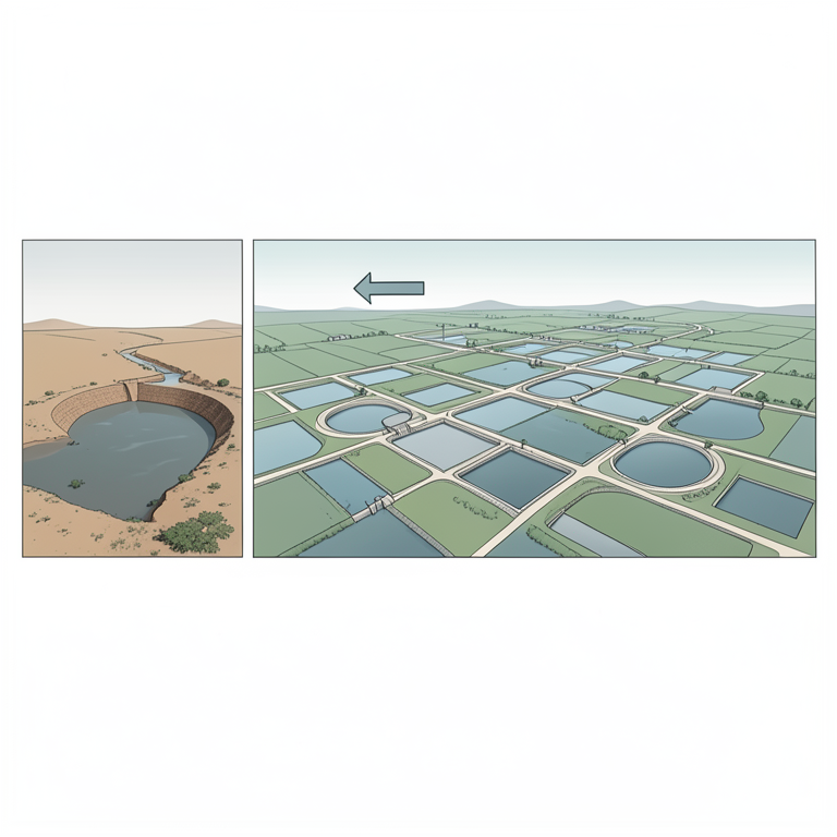
Growth of Irrigation Projects
AI-generated conceptual illustration (small-scale irrigation dams and canals in a rural Maharashtra landscape). It explains the idea and does not show study data.
View source evidence ↗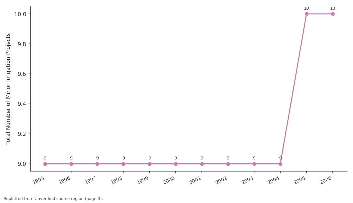
Jamkhed: 1995 vs 1996 vs 1997 vs 1998 vs 1999
Replotted from a table (page 3) of the original paper. Every bar is the paper's own table value.
View source evidence ↗Figures & tables
From the original paper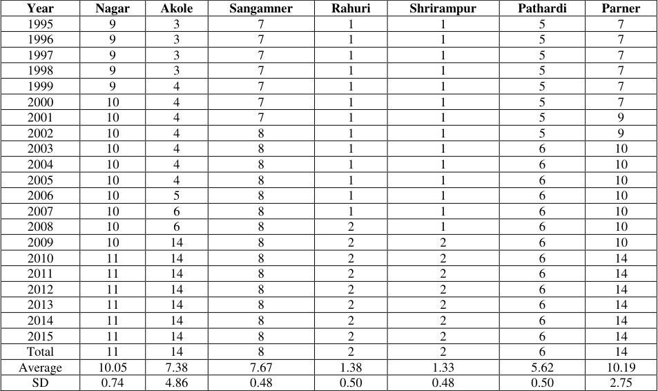 Table 1
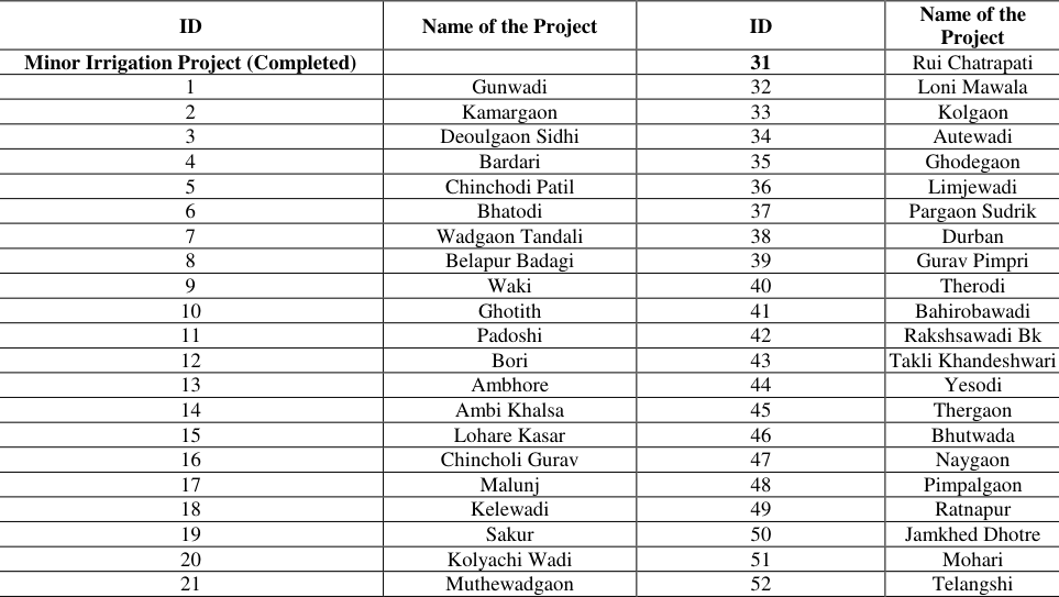 Table 1
Introduction
Minor irrigation projects will play a key role in addressing the need of domestic, irrigation and industrial. The water source for a minor irrigation project could be either surface or ground water. In this research paper water management through Minor projects is discussed. Water management is important since it helps determine future domestic, irrigation and industrial expectations. Water management is the management of water resources under set policies and regulations. Water, once an abundant natural resource, is becoming a more valuable commodity due to droughts and overuse [1] . Geographical study of minor irrigation projects in Ahmednagar district is important. Ahmednagar district is a large and important district of Maharashtra, and minor irrigation projects are important to improve irrigation facilities here. This geographical study includes the locations of these projects, their capacity, and the area irrigated by them [2] . In Maharashtra, minor irrigation projects are defined as those with a culturable command area (CCA) of 2,000 hectares or less. These projects typically utilize water tanks, small canals, and groundwater systems as their primary water sources [3] .
Some major Minor irrigation projects in Ahmednagar district
Mula Irrigation Project: This is a large irrigation project, but there are also small ponds and dams under it which are useful for irrigation. Kukdi Irrigation Project: This is also a large project, and there are also small projects associated with it. Tajnapur Lift Irrigation Scheme: This scheme has been entrusted to Nandur Madhameshwar Irrigation Department, Vaijapur [4] .
Importance of the Study
Water Management: By studying Minor irrigation projects, it is possible to estimate the availability of water and plan irrigation accordingly Drought Relief: Based on this study, it becomes easier to provide water to droughtaffected areas. Agricultural Development: With the improvement of irrigation facilities, it is possible to get good production in agriculture and thus agricultural development can be achieved. Environmental Protection: With proper water management, the ground water level improves and the environment is protected [5] .
Study Area: Ahmednagar district is lying between 18 0 2' to 19 0 Murbad and Shahapur tahsils of Thane district [6] . It has the total area 17035 sq.km. Ahmednagar is the largest district of the state in area. It occupies somewhat central position in Maharashtra.The total area of Ahmednagar district is 17,048 square kilometers. The district has 14 talukas and a population of 4,543,159. Some parts of the district are hilly, while some parts are flat [7] .
Methodology
A comprehensive geographical study would employ a combination of primary and secondary data sources. This would include:
The secondary data was collected during the period of 1995. The data regarding minor projects as well as its capacity of water storage, utilization of water and its management was used for the study.
Method of Analysis
The data related to the study feed into a computer and verified in order to eliminate errors. One way and two-way tabular analysis with appropriate statistics like percentage, average, and co-relation used in the analysis of data.
Data Analysis
The study is limited to only working capital management covering various ratios related to working capital. The tool for appraisal of working capital management is ratio analysis. The data has analyzed with the help of financial and statistical tools viz. ratio analysis, percentage and average, Standard Deviation, Coefficient of Variation and Compound annual growth rate (CAGR). Graphs and Diagrams have presented to illuminate the facts and figures.
Arithmetic Mean
Arithmetic mean gives a single value to describe the whole data. Simple arithmetic mean of each series of different ratios has been obtained by adding the values of observations and dividing it by the number of observations.
Standard Deviation:
The standard deviation is the most extensively used for calculating significant evaluation of deviation. The standard deviation, also well-known as root mean square deviation, is generally expressed by the Greek letter σ this can be calculated by following formula:-Where, Σ = Summation, X = Individual value, = Mean of all values, N = Sample size (Number of values) [8] Data Analysis and Interpretation: Investigating the primary water sources for these projects (e.g., groundwater, surface runoff) and assessing their recharge potential, especially in relation to rainfall patterns and geological formations [9] . By integrating these approaches, the geographical study of minor irrigation projects in Ahmednagar district can provide valuable insights into the role of these projects in sustainable water management and agricultural development in a drought-prone region [10] . [11] .
A map index help us to find specific spot on the map using the grid. A map's legend explains what the symbols on a map used. The code numbers in the map show the names of the minor irrigation projects in the Ahmednagar district as shown in the map index. This map provides information of the irrigation project in the Ahmednagar [12] .
Map 1.2 Minor Irrigation Project Status Map of Ahmednagar District
Tehsil-wise and year-wise number of minor irrigation projects in Ahmednagar district has been shown in Table and Graph 1.1. The table revealed that there is no change in the number of minor irrigation projects from 1995 to 2000 due to unconstruction of new projects. During the period of investigation, there are 82 total minor irrigation projects in the district. Out of the total 82 minor irrigation projects in the Ahmednagar District, the highest increase has been seen in the year 2010 to 2015, while other years noted a drastic changes. It can be seen from table and graph no. 1.1 that there is change in the number of projects after gap period of 5 years. The table further revealed that the highest number of minor irrigation projects was found in the tehsils of Akole and Parner whereas remaining tehsils recorded lowest numbers. It is same as 14 for both, as they having favourable sites to develop minor irrigation projects. Overall, the total number of minor irrigation projects has increased from 56 to 82 from 1995 to 2015. It is an under construction/ constructed multi-purpose minor irrigation project on the Pravara river in Ahmednagar district. It shall be the last project to be accorded the minor irrigation project status. A large standard deviation, which is the square root of the variance, indicates that the data points are far from the mean or average and small standard deviation indicates that they are clustered closely around mean or average. Above table no. 1.1 also shows that, Average and SD of tehsil wise number of Minor Irrigation Project in Ahmednagar District. In that tehsil-wise Ahmednagar has maximum minor irrigation with average 10.05 and SD of 0.74 whereas Shrirampur has mean, SD is 1.33 and 0.48 respectively. On the other hand year-wise, since year 2010 to 2015 has maximum minor irrigation with Mean and SD is 8.20, 4.29 respectively and minimum in the year of 1995 to 1999 with Mean, SD is 5.0 and 3.13 respectively.
Conclusions
Ahmednagar district, especially the parts of Marathwada region, often faces drought-like conditions. Therefore, minor irrigation projects are important to increase water availability and improve irrigation facilities. their locations, source of water availability, soil type, and area to be irrigated are considered. This makes it easy to select projects and implement them effectively. Thus, the geographical study of Minor irrigation projects in Ahmednagar district is very important for the development of the district and improvement of water availability.
Figures and tables from the paper
| Year | Nagar | Akole | Sangamner | Rahuri | Shrirampur | Pathardi | Parner |
|---|---|---|---|---|---|---|---|
| 1995 | 9 | 3 | 7 | 1 | 1 | 5 | 7 |
| 1996 | 9 | 3 | 7 | 1 | 1 | 5 | 7 |
| 1997 | 9 | 3 | 7 | 1 | 1 | 5 | 7 |
| 1998 | 9 | 3 | 7 | 1 | 1 | 5 | 7 |
| 1999 | 9 | 4 | 7 | 1 | 1 | 5 | 7 |
| 2000 | 10 | 4 | 7 | 1 | 1 | 5 | 7 |
| 2001 | 10 | 4 | 7 | 1 | 1 | 5 | 9 |
| 2002 | 10 | 4 | 8 | 1 | 1 | 5 | 9 |
| 2003 | 10 | 4 | 8 | 1 | 1 | 6 | 10 |
| 2004 | 10 | 4 | 8 | 1 | 1 | 6 | 10 |
| 2005 | 10 | 4 | 8 | 1 | 1 | 6 | 10 |
| 2006 | 10 | 5 | 8 | 1 | 1 | 6 | 10 |
| 2007 | 10 | 6 | 8 | 1 | 1 | 6 | 10 |
| 2008 | 10 | 6 | 8 | 2 | 1 | 6 | 10 |
| 2009 | 10 | 14 | 8 | 2 | 2 | 6 | 10 |
| 2010 | 11 | 14 | 8 | 2 | 2 | 6 | 14 |
| 2011 | 11 | 14 | 8 | 2 | 2 | 6 | 14 |
| 2012 | 11 | 14 | 8 | 2 | 2 | 6 | 14 |
| 2013 | 11 | 14 | 8 | 2 | 2 | 6 | 14 |
| 2014 | 11 | 14 | 8 | 2 | 2 | 6 | 14 |
| 2015 | 11 | 14 | 8 | 2 | 2 | 6 | 14 |
| Total | 11 | 14 | 8 | 2 | 2 | 6 | 14 |
| Average | 10.05 | 7.38 | 7.67 | 1.38 | 1.33 | 5.62 | 10.19 |
| SD | 0.74 | 4.86 | 0.48 | 0.50 | 0.48 | 0.50 | 2.75 |
Table text extracted from the original PDF; superscript letters are shown inline. The original table image is below.
View original table image
| ID | Name of the Project | ID | Name of the Project |
|---|---|---|---|
| Minor Irrigation Project (Completed) | 31 | Rui Chatrapati | |
| 1 | Gunwadi | 32 | Loni Mawala |
| 2 | Kamargaon | 33 | Kolgaon |
| 3 | Deoulgaon Sidhi | 34 | Autewadi |
| 4 | Bardari | 35 | Ghodegaon |
| 5 | Chinchodi Patil | 36 | Limjewadi |
| 6 | Bhatodi | 37 | Pargaon Sudrik |
| 7 | Wadgaon Tandali | 38 | Durban |
| 8 | Belapur Badagi | 39 | Gurav Pimpri |
| 9 | Waki | 40 | Therodi |
| 10 | Ghotith | 41 | Bahirobawadi |
| 11 | Padoshi | 42 | Rakshsawadi Bk |
| 12 | Bori | 43 | Takli Khandeshwari |
| 13 | Ambhore | 44 | Yesodi |
| 14 | Ambi Khalsa | 45 | Thergaon |
| 15 | Lohare Kasar | 46 | Bhutwada |
| 16 | Chincholi Gurav | 47 | Naygaon |
| 17 | Malunj | 48 | Pimpalgaon |
| 18 | Kelewadi | 49 | Ratnapur |
| 19 | Sakur | 50 | Jamkhed Dhotre |
| 20 | Kolyachi Wadi | 51 | Mohari |
| 21 | Muthewadgaon | 52 | Telangshi |
Table text extracted from the original PDF; superscript letters are shown inline. The original table image is below.
View original table image
References
10 in the original paper- Government of Maharashtra. Groundwater Surveys and Development Agency (GSDA). Maharashtra: GSDA; Command Area Development Authority, Ahmednagar. CDAP Report 2011-12. Ahmednagar: CDAP; 2012.
- Command Area Development Authority, Ahmednagar. CDAP Report 2011-12. Ahmednagar: CDAP; 2012.
- Central Water Commission of India. Water and Related Statistics. New Delhi: Central Water Commission; 2010.
- Central Water Commission, Ministry of Water Resources. Guidelines for Improving Water Use Efficiency in Irrigation. New Delhi: CWC; 2014.
- Purandare P. Golden mean for water policy. Sakal. 2014 May 18;Sunday issue.
- Purandare P. Golden mean for water policy. Sakal. 2014 May 18;Sunday issue.
- Government of Maharashtra. Economic Survey of Maharashtra 2012-13, 2013-14. Mumbai: Directorate of Economics and Statistics; 2014.
- Kathpalia GN, Kapoor R. Water Policy and Action Plan for India 2020: An Alternative. New Delhi: Alternative Futures, Development Research and Communications Group; 2002. p. 12.
- Kathpalia GN, Kapoor R. Water Policy and Action Plan for India 2020: An Alternative. New Delhi: Alternative Futures, Development Research and Communications Group; 2002. p. 12.
- Water Resources Department, Government of Maharashtra. Godavari Study Group Report. Mumbai: WRD; 2013 Aug. p. 3-4.