
Research article · 2025 · Full text
International Journal of Geography Geology and EnvironmentGeological characteristics and its influences on the topography: A case study on santiniketan and its surroundings
Volume 7(6) · Pages 05–13 · DOI: 10.22271/27067483.2025.v7.i6a.368 ↗
Research areasGeochemistry and Geologic MappingArchaeological Research and ProtectionImage Processing and 3D Reconstruction
Abstract
Author-writtenGeography focuses on the description and analysis of surface and sub-surface phenomena of the earth, impacting on landforms patterns and relief aspects. Santiniketan and its surroundings have unique geological characteristics and topographical scenarios, such as red soil with ravine-like formations along the River Kopai. The present paper is focusing on major geological Characteristics and its impact on changes of topographical features of Santiniketan and its surrounding area. It has worked out through the study of geological structure and preparing DEM (Digital Elevation Model) to investigate regional geomorphology. It outlines the several maps to establish the facts behind the relationship between geological condition and topographical situation. At the same time the author would like to highlight spatial integration of morphogenetic aspects for the better understanding of landscape ecology.
Summary
Source-checkedPlain-language reading of the full paper, prepared with AI and checked against the text. Each point links to the authors' own words.
Why it matters
- The geological characteristics of a land area significantly influence its topographical and morphological phenomena, including relief aspects and landform patterns. View evidence ↗
- The landscape of Santiniketan is uniquely characterized by red soil and ravine-like formations known as Khoai along the River Kopai. View evidence ↗
- Analyzing the geological characteristics of Santiniketan provides insight into its topographic conditions and helps formulate morphological dimensions for the area's development. View evidence ↗
What they did
- The research relied primarily on secondary data, including books, reports, maps of the Birbhum District, and photographs from the Rabindra-Bhavana and Visva-Bharati libraries. View evidence ↗
- Geological and geomorphological maps were developed using data from the Geological Survey of India (1985) and the National Remote Sensing Centre (2011). View evidence ↗
What they found
- Laterite, consisting of ferricrete-hard crust, laterite nodules, and lithological clay, is the dominant geological type, covering approximately 86.80% of the total area. View evidence ↗
- Older Alluvium (sand with silt and clay) and Recent Alluvium (sand dominant) cover approximately 8.50% and 4.70% of the area, respectively. View evidence ↗
- The study area's elevation ranges from a maximum of 67 meters to a minimum of 33 meters. View evidence ↗
- The highest elevation is found in the central part of the region, with elevations gradually decreasing toward the north and south by 20 to 30 meters. View evidence ↗
- The Dissected Lateritic Upland zone is characterized by elevations between 50-67 meters, relative relief greater than 17 meters, and high drainage. View evidence ↗
- The Younger Alluvial Plain zone has the lowest elevation range of 34-40 meters and low drainage. View evidence ↗
- The Medinipur-Farakka Fault (MFF) passes through the upland area of Bolpur-Santiniketan, contributing to the region's geological instability. View evidence ↗
What it means
- The authors conclude that Santiniketan is a rolling upland transitioning between east and west, where gully erosion from the Kopai River's tributaries creates a Badlands topography. View evidence ↗
- The unique geological and topographical features of the landscape, particularly the Khoai, have significantly influenced the cultural, artistic, and literary works associated with Santiniketan. View evidence ↗
Visual summary
3 visualsIllustrations explain the paper; charts are replotted from the paper's own table values.
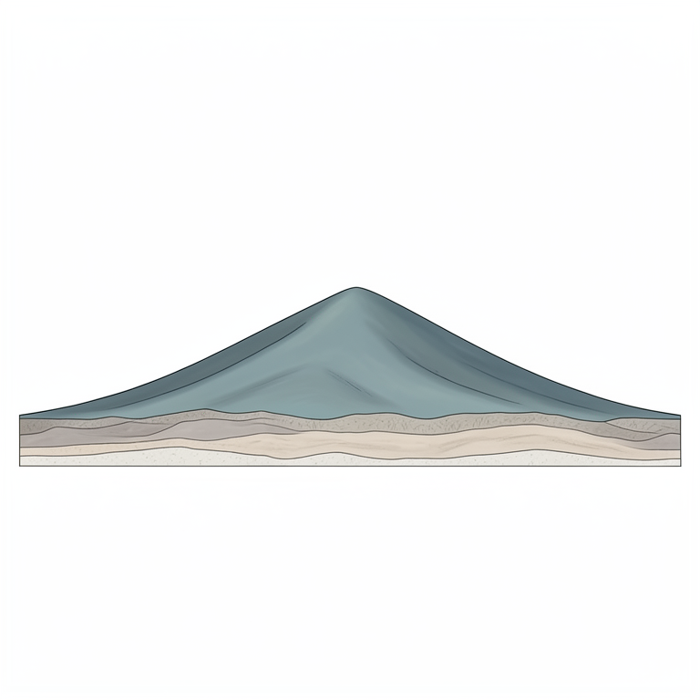
Elevation Profile of Santiniketan
AI-generated conceptual illustration (The landscape topography of Santiniketan, West Bengal). It explains the idea and does not show study data.
View source evidence ↗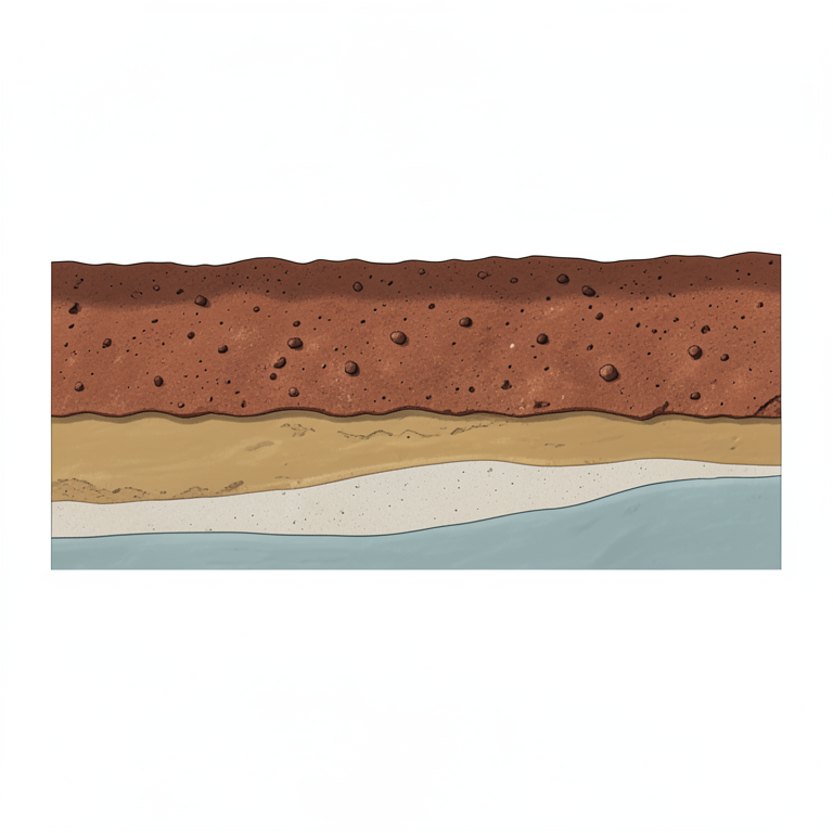
Geological Composition Distribution
AI-generated conceptual illustration (Geological cross-section of the Santiniketan landscape). It explains the idea and does not show study data.
View source evidence ↗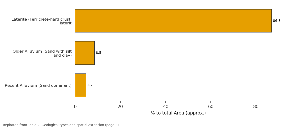
% to total Area (approx.): Laterite... vs Older Alluvium (Sand... vs Recent Alluvium (Sand...
Replotted from Table 2 (page 3) of the original paper. Every bar is the paper's own table value.
View source evidence ↗Figures & tables
From the original paper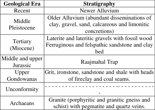 Table 1
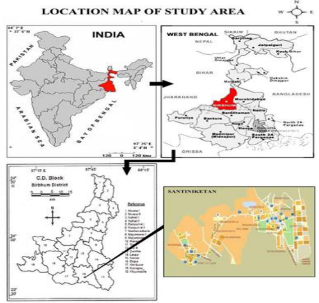 Figure 1
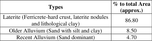 Table 2
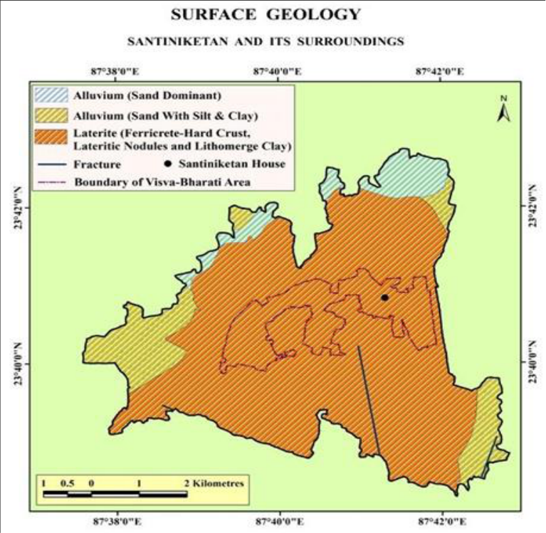 Figure 2
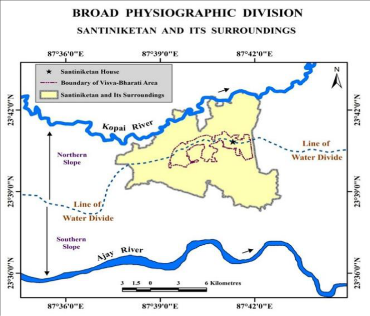 Figure 3
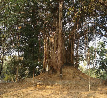 Plate 1
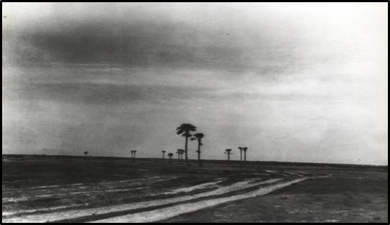 Plate 2
 Table 3
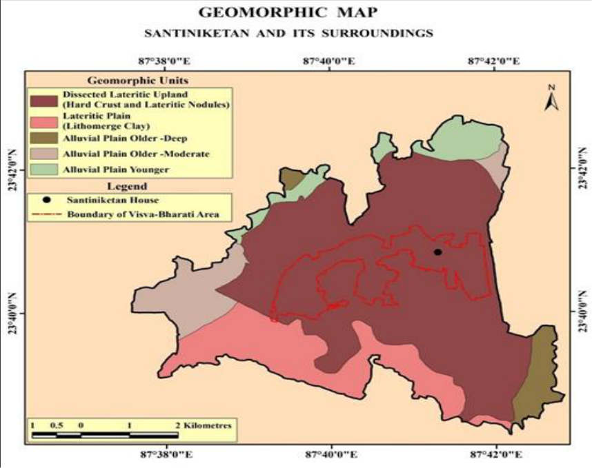 Figure 4
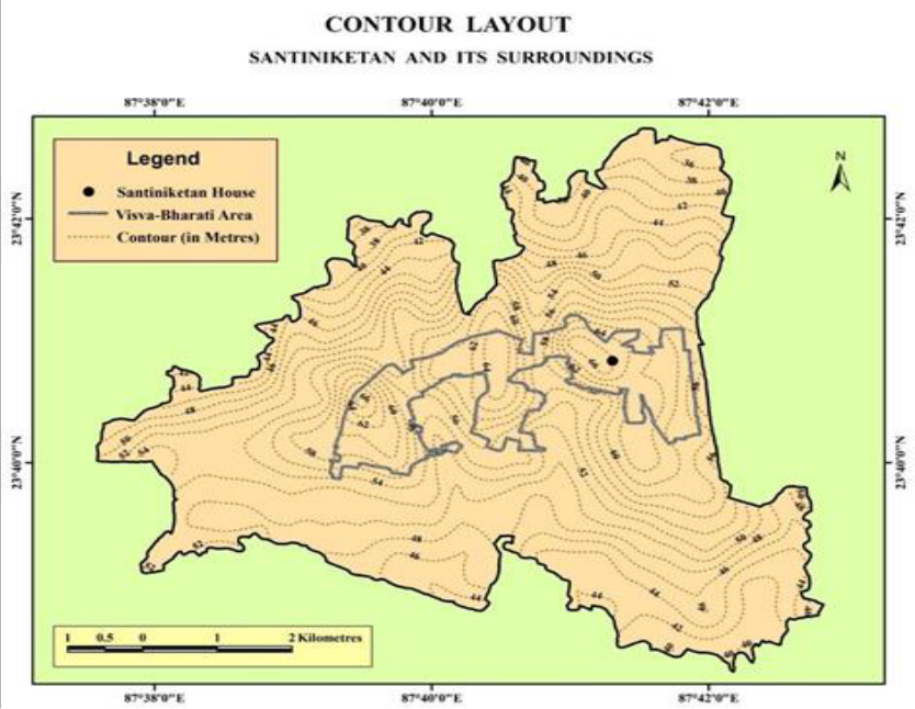 Figure 5
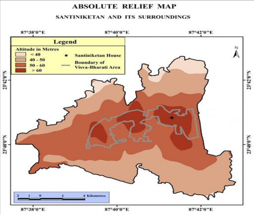 Figure 6
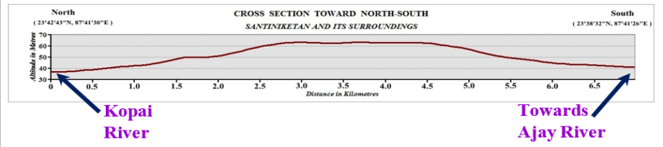 Figure 7
Introduction
Geography has been largely concerned with the description and analysis of surface (topography) and sub-surface (geology) phenomena of the earth. Geological Characteristics of a piece of geographical land has very significant impacts on topographical and morphological phenomena. It also imparts ample influences on landforms pattern, relief aspects etc. It encompasses the geological situation and associated phenomena as well (Blinnikov, 2011) [1] . Rock compositions, underlying structure, presence of fault line of a place helps to understand the geomorphological characteristics which ultimately influence land use and land cover of that area (Das, 2014) [2] . Santiniketan and its surroundings has carried down its own type of geological characteristics and topographical scenario. These two are largely related geographical factors to expose a physical landscape that has unique characteristics in terms of spatial pattern. The Santiniketan landscape is characterized by red soil with ravine-like formations (Khoai) along the River Kopai. This gives such places an appearance of microcosms of hill ranges carved out of reddish, leached, laterized and gravelly soil, in which deep gullies are created by surface run-off of rainwater naturally draining towards the Kopai River (Das, 1986) [3] .
Selection and importance of the study
Geological characteristics play a significant role in shaping the topography of a region. The Earth's surface is constantly changing due to geological processes. Santiniketan and its surroundings exhibit distinct geological characteristics that significantly influence the region's topography. The geological characteristics of the Santiniketan have had a direct influence on its landscape, environment, and even historical development. Description of the geological characteristics of Santiniketan can offer an idea about the topographic condition. It will help to understand and formulate morphological dimensions for developing the prospects of the study area. That is the most valid point of this chosen topic.
Location of the study area
Geographically, Santiniketan lies between 23º38′30″N -23º39′30″N latitudes and 87º41′30″E -87º43′00″E longitude in the northern hemisphere. According to the UTM (Universal Transverse Mercator) Projection, this area is located under the 45Q zone. It is in an inter-riverine tract of river Ajoy and Kopai, which is a segment of the Rarh region of the Lower Ganga Plain. It is situated in the southernmost part of Birbhum District within Bolpur-Sriniketan Block (Figure 1).
Database and Methodology
Data was collected mainly from secondary sources. Several books and Reports, some photographs from Rabindra-Bhavana Library (with due legal permission), Visva-Bharati Central Library and maps related to Santiniketan and Birbhum District as well. Digital elevation model (DEM) has been generated from elevation data at (15"×15") coordinate points (latitude and longitude) using Google Earth and TCX converter with the help of GIS software. Also prepared some geological and geomorphological maps using the data collected from Hydrogeology Division, National Remote Sensing Centre of Indian Space Research Organization, 2011; Geological Survey of India, 1985.
Geological Characteristics
Geology is the study of the interior in terms of nature and characteristics of geomaterial, position or inclination of the rock strata, its genesis and evolution etc. As the geological condition massively influences the geomorphological prevalences, drainage condition as well as ecological environment in broad term (Pal, 2005) [4] .
Pattern of Sub-Surface Geology
From the point of geology, the region is under Chhotonagpur plateau fringe zone. The geological succession found in Santiniketan and its surroundings is as follows (given in the table-1). Unconformity ----------------------------------Archaeans Granite (porphyritic and granitic gneiss and schist) with pegmatite and quartz veins. Source: Wadia DN, Geology of India, 1964 and GSI, 1985 6.2 Pattern of Surface Geology: From the study of the Quaternary Formations of Birbhum district by Geological Survey of India (GSI), 1985, it is evident to say that the study area is three geological segments i.e. i) Laterite, ii) Older Alluvium, and iii) Recent Alluvium. All these segments are found within this small study area (see vide Figure 2).
I) Laterite (Ferricrete-hard crust, laterite nodules and lithological clay)
Large portion of the study area is composed of lateritic soils containing a high portion of iron (see vide table-2). This pisolitic type of platy or columnar, moram geomaterial is very common, somewhere it is overlain by whitish clay. The depth of the lateritic layer varies from place to place i.e. somewhere it is only a few inches or sometimes likely greater than 4 m.
II) Older Alluvium (sand with silt and clay)
Older alluvium is generally found at the northern part of the region which was mainly developed by the inundations of Kopai River. Older alluvium sometimes is found beneath the lateritic strata scattered over this zone. Sand with silt and clay alluvium is presented along the river course of Kopai.
III) Recent Alluvium (Sand dominant)
Younger types of alluvium are found along the river course of Kopai, where the rate of inundation frequently happens every year, even twice a year. It is also thinly found over the lateritic strata where the rate of erosion is substantially low.
Presence of Fault Line
Three successive major faults-Chhotanagpur Foot-hill Fault, Medinipur-Farakka Fault and Damodar Fault (northsouth trend) extend for variable distances into the overlying Cretaceous-Paleocene sequences of the western Tectonic Shelf of the Bengal Basin and the Lower Gangetic landforms of Bengal Basin had been formed due to reactivation of these faults (Wadia, 1964) [5] . The lateritic Rarh region of Bengal is bounded by Chhotanagpur Foot-hill Fault (CFF) at west and Medinipur-Farakka Fault (MFF) at east. The Medinipur-Farakka Fault (MFF) within the Tectonic Shelf separates the low-level laterites of Rarh Bengal (i.e. upland red soils) in the west from the soils of Bhagirathi-Ajay-Damodar Deltaic Plain in the east. The Medinipur-Farakka Fault (MFF) crosses through the upland of Bolpur-Santiniketan area. For that reason, the few isolated patches of lateritic exposures (compound lateritic profiles) are found at a distance from MFF in and around Bolpur, following the fault-line scarp (Ghosh and Guchhait, 2015) [6] . Uplifted block (in between CFF and MFF) and its influences on seasonal groundwater regime, sub-aerial exposure, strong leaching, irreparable dehydration, well sub-surface drainage and prolonged erosion makes such a kind of surface geological condition (See Vide Fig 1). Thus, the Santiniketan area is in an unstable zone from the geological view point.
Influences on Topography
Santiniketan and its surroundings are in the fringe area of Chhotanagpur plateau. The area under study is undulating in topography being an extension of the plateau and is made up of unconsolidated and semi-consolidated rock formation. It is situated in the inter-fluvial region of Ajay and Kopai River. An "Interfluves are the region of higher land between the two rivers that are in the same drainage system" (Kumar, 2014) [7] (See Vide Figure 3). Central part of the area was relatively high. Height gradually declines toward the surroundings from the central part. The area is the part of regional westerly to easterly slopes i.e. west to east direction overall. But at the local level, the slope of this region is toward north and south from the central point (See Vide Figure 3). The ground slopes decrease gradually to 33 to 34 metres above sea-level near the Ajay River to the south and the Kopai River to the north. After the establishment of Santiniketan ashrama in 1863, a pond was excavated by Maharshi for the use of rainwater in 1868-69. The plan of pond excavating had failed as rain water was not retained in the pond; therefore, in the year of 1961, the pond was completely blocked. Consequently, a new landscape having three-fold had been formed through deposition of cutting soil from a pond, which was known as 'Tin Pahar' (three hills) of Santiniketan (Bandopadhyay, 2010) [8] .
Source: Prepared from Digital Elevation Model, 2016
Source: Prepared from Digital Elevation Model, 2016
Geomorphological Characteristics
The Geomorphological features are the natural outlook on the surface of the earth crust that has been imprinted by different denudational agents such as wind, water etc. Geomorphology of any region completely depends upon the climate, lithology and tectonics of that region (Kumar, 2014) [9] . The well-known concept 'the present is key to the past' is very much relevant to know the geomorphological characters of Santiniketan region. Surface elevation and forms have been taken as parameters to classify and evaluate the terrapins (geomorphic features) of this upland region (See Vide Table-3 and Figure 4). Most of the area lies under lateritic upland (with hard crust and lateritic nodules). Geomorphologically, laterites are found here in two settings-( 1) as continuous crusts on top-elevated area where they act as hard caps on the table-like landforms and source of ferralitic materials, and (2) at foot-slopes or low-elevated area as deposited ferruginous crust in seepage areas of soil. Lateritic soilscapes of Santiniketan are ecologically fragile due to its inherent constraints of acidity, nutrient loss, chemical impairment, crusting, water erosion and poor water holding capacity (Jha, 2005) [10] . Therefore, it creates different types of landforms-Ravine topography i.e. highly dissected infertile land.
Relief Aspects
The term 'relief' refers to all the landforms on the surface of the earth. From the viewpoint of relief aspects, Santiniketan and its surrounding area belong to the area of 'Surul Upland' (Sarkar, 2010) [11] . The higher ground of a region contrasted with the valleys and plains or to lowland is generally known as 'Upland'. Thus, upland is a surface of land relatively with higher altitude than its surrounding areas generally characterized by undulating surfaces alternated with valleys and spurs of low magnitude (Sarkar, 2015) [12] . Maximum elevation of this region is 67 metres at the central portion and lowest is about 33 metres at the river valley in the north. Sudden break of slope along 40 and 50 metres contours clearly mentioned the demarcation line among upper, middle and lower segments. But, a 60 metres contour identifies three land patches over the upper segment (See Vide Figure 5). Areas of maximum and minimum elevations in the Santiniketan are shown in fig. 3. Surface elevation of this region ranging from less than 33 metres to 67 metres from the river bed to the small hills shows the general relief pattern of the study area.
Major landscapes in santiniketan region
As a structural outlook, the landscape of Santiniketan is the topography of 'Rolling Upland'. It represents a transition between the extensive plain to the east and the hilly west. The landscape is characterized by low spurs extending eastwards. The right tributaries of Sal or Kopai River display the gully erosion resulting in Badlands topography (local name Khoai) to the north of Santiniketan. The slope of this rolling upland gradually merges into the broad alluvial plains of the Gangetic delta in the south-east (Ghosh, 2012) [13] .
Undulating Plain: The Undulating plain is mainly formed by crossing two major rivers-River Kopai and Ajay. Small residual low elevated poorly defined ridges are scattered in the central part towards east to west of the study area. Ravine or Badlands topography: Highly dissected infertile land with several aesthetic landforms has been generated in Santiniketan mainly in the north and northwest part. It is briefly discussed later. River Valley: The river valley of Kopai river basin is a significant landscape on the north side of this region. Channel shifting, Paleo-channel and sand bar etc. are few common features of this area. The Upasana Griha is located at the topmost elevated land patch of Santiniketan area, especially in the line of water divide of Kopai and Ajay River system.
Major Findings
Santiniketan and its surrounding areas belong to the 'Surul Upland', characterized by undulating surfaces and lowmagnitude valleys. The region's maximum elevation is 67 meters, with the lowest at 33 meters. The study area has surface elevations ranging from 33 to 67 meters, with the maximum in the central part and gradual decreases in the north and south up to 20 to 30 meters. Also, Santiniketan and its surroundings are in the low-level laterites of the Rarh Bengal i.e. secondary lateritic belt. It is impact in Santiniketan on-• Relief (through formation of ravine land),
• Soil (creation of red soil with calcareous nodules),
• Vegetation (less vegetal cover area due to presence of duricrust) and • Climate (intolerable hot climatic conditions due to absorption of more heat) etc.
The zone of unconformity is the evidence of large-scale crustal movements and deformation that brought about revolutionary changes in the physiography. Three small hillocks (like knoll pattern landscape). Visva-Bharati area is in the uppermost area of this region.
Conclusion
Santiniketan's landscape is a rolling upland transitioning between east and west, with low spurs and gully erosion. The right tributaries of Kopai River create Badlands topography, merging into the Gangetic delta. This gives such places an appearance of microcosms of hill ranges carved out of reddish, leached, laterite and gravelly soil, in which deep gullies are created by surface run-off of rainwater naturally draining towards the Kopai River. All these features act as a backdrop, which also inspired Tagore and many other artists in their creations. Even people from outside would like to visit places such as the Khoai and Kopai to get recharged or just to spend time by themselves. At present, Khoai is considered a rare phenomenon, but it contributes significantly to the Santiniketan landscape. Its unique presence in the landscape reflects powerfully in cultural, artistic, and literary productions related to Santiniketan.
Figures and tables from the paper
| Types | % to total Area (approx.) |
|---|---|
| Laterite (Ferricrete-hard crust, laterite nodules and lithological clay) | 86.80 |
| Older Alluvium (Sand with silt and clay) | 8.50 |
| Recent Alluvium (Sand dominant) | 4.70 |
Table text extracted from the original PDF; superscript letters are shown inline. The original table image is below.
View original table image
| Zones | Elevation (metre) | Relief (relative relief in metre) | Drainage (Stream Association) | Geological type |
|---|---|---|---|---|
| Dissected Lateritic Upland | 50-67 | >17 | High | Laterite |
| Lateritic Plain | 40-54 | >10 | Low | Laterite |
| Alluvial Plain Older- Deep | 38-48 | > 8 | Low | Older Alluvium |
| Alluvial Plain Older- Moderate | 38-56 | > 6 | Low | Older Alluvium |
| Alluvial Plain Younger | 34-40 | > 4 | Low | Recent or Newer Alluvium |
Table text extracted from the original PDF; superscript letters are shown inline. The original table image is below.
View original table image
References
13 in the original paper- Blinnikov MS. A Geography of Russia and Its Neighbours. London: The Guilford Press, 2011, p. 448.
- Das P. Hydro-geomorphic characteristics of Kuya River Basin in Eastern India and their impact on agriculture and settlement [Ph.D. Thesis]. Department of Geography, Visva-Bharati, 2014.
- Visva-Bharati, 1986.
- Pal S. Landscape of Khoai and its impact on human ecology [dissertation]. Department of Geography, Visva-Bharati, 2005, p. 34.
- Wadia DN. Geology of India. Calcutta: Macmillan Co. Ltd, 1964, p. 398.
- Ghosh S, Guchhait SK. Characterization and evolution of primary and secondary laterites in northwestern Bengal Basin, West Bengal, India. Journal of Palaeogeography. 2015;4(2):203-230. DOI: 10.3724/SP.J.1261.2015.00074.
- Kumar D. Geomorphology of Ghaghara-Ganga interfluve between Faizabad and Kanpur region [Ph.D. Thesis]. Centre of Advanced Study in Geology, University of Lucknow, 2014.
- Bandopadhyay A. Chhatimtala theke udichi: ParibeshSthapatya Gantha. In: Som TK, et al. Editors. Rabindranather shantiniketa o Sriniketan. Kolkata: Deep Prakashan, 2010, p. 487. (In Bengali)
- Kumar D. Geomorphology of Ghaghara-Ganga interfluve between Faizabad and Kanpur region [PhD thesis]. Centre of Advanced Study in Geology, University of Lucknow, 2014.
- Jha VC. Denudational processes and landform characteristics of lateritic terrain of Birbhum district, W.B., India. Transactions of the Institute of Indian Geographers. 2005;27(1):19-29.
- Sarkar S. Land acquisition for the railways in Bengal, 1850-62: probing a contemporary problem. Studies in History. 2010;26(2):103-142. DOI: 10.1177/025764301002600201.
- Sarkar R. Terrain evaluation for agricultural land use and planning in the Burdwan upland, West Bengal [PhD thesis]. Department of Geography, University of Burdwan, 2015. Available from: http://hdl.handle.net/10603/56935.
- Ghosh R. A poet's school: Rabindranath Tagore and the politics of aesthetic education. South Asia: Journal of South Asian Studies. 2012;35(1):13-32. DOI: 10.1080/00856401.2012.648900.