
Research article · 2025 · Full text
International Journal of Geography Geology and EnvironmentSoil erosion estimation in G-K watershed using geospatial techniques and universal soil loss equation (USLE)
Volume 7(3) · Pages 46–48 · DOI: 10.22271/27067483.2025.v7.i3a.364 ↗
Research areasSoil erosion and sediment transportGroundwater and Watershed AnalysisSoil and Land Suitability Analysis
Abstract
Author-writtenSoil erosion is arncritical environmental problem that significantly affects agricultural productivity,rnwater quality and ecosystem sustainability. The G-K (Ghaggar-Karnal) Watershed,rnsituated in the semi-arid zones of Haryana and Punjab, is particularlyrnvulnerable to soil erosion due to high-intensity rainfall events, anthropogenicrnland-use changes and poor conservation practices. This study estimates thernaverage annual soil loss in the G-K Watershed using the Universal Soil LossrnEquation (USLE) integrated with Remote Sensing (RS) and Geographic InformationrnSystem (GIS) techniques. Various thematic layers, such as rainfall erosivityrn(R), soil erodibility (K), slope length and steepness (LS), land cover (C) andrnconservation practice (P) were generated using satellite imagery, digitalrnelevation models (DEM) and field data. The results reveal spatial variation inrnerosion, with critical areas showing erosion rates above 40 tons/ha/year. Thesernfindings emphasize the need for immediate soil and water conservationrninterventions in high-risk sub-watersheds. Soil erosion posesrna major threat to land productivity, hydrological balance and environmentalrnsustainability in watershed regions across India. The G-K (Ghaggar-Karnal)rnWatershed, covering parts of Haryana and Punjab, is highly susceptible to soilrndegradation due to intensive agriculture, deforestation, erratic rainfall andrnimproper land management practices. Soil erosion not only reduces soilrnfertility but also contributes to siltation in reservoirs and degradation ofrnwater quality downstream. Accurate estimation and spatial assessment of soilrnerosion rates are essential for implementing effective soil conservationrnstrategies. This study aims to estimate soil erosion in the G-K Watershed usingrnthe Universal Soil Loss Equation (USLE) integrated with Geographic InformationrnSystem (GIS) and Remote Sensing (RS) techniques.
Summary
Source-checkedPlain-language reading of the full paper, prepared with AI and checked against the text. Each point links to the authors' own words.
Why it matters
- Soil erosion is a major environmental issue that negatively impacts ecosystem sustainability, water quality, and the productivity of agriculture. View evidence ↗
- The G-K (Ghaggar-Karnal) Watershed in Haryana and Punjab is highly susceptible to erosion because of poor conservation, human-driven land-use changes, and high-intensity rain. View evidence ↗
- Beyond reducing fertility, soil erosion leads to the degradation of downstream water quality and the siltation of reservoirs. View evidence ↗
The question
- The study aims to estimate soil erosion within the G-K Watershed by integrating the Universal Soil Loss Equation (USLE) with Remote Sensing (RS) and Geographic Information System (GIS) techniques. View evidence ↗
What they did
- The study area is the G-K watershed in northwestern India (Fatehabad, Sirsa, and Karnal districts), covering approximately 3,000 km². View evidence ↗
- Data sources included IMD rainfall data (2001-2020), NBSS&LUP soil texture, 30m resolution SRTM DEM, and 2023 Landsat-8 OLI land cover data. View evidence ↗
- The final soil erosion map was generated by performing raster multiplication of the five USLE factors using ArcGIS 10.8 and QGIS 3.24. View evidence ↗
What they found
- Estimated soil erosion in the G-K watershed ranged from 0.1 to 60 tons/ha/year, with an average loss of approximately 15 tons/ha/year. View evidence ↗
- The watershed area was categorized by erosion rate: 28% was very low (< 5 tons/ha/yr), 22% low (5-10), 25% moderate (10-20), 17% high (20-40), and 8% very high (> 40 tons/ha/yr). View evidence ↗
- High erosion was primarily concentrated in the western and southern regions, particularly where vegetation was sparse and slopes were steep. View evidence ↗
What it means
- The authors conclude that identifying erosion-prone sub-watersheds allows for targeted interventions, including sustainable farming, bunding, and afforestation. View evidence ↗
- The authors note a research gap in integrating watershed science with social and educational impact analysis, suggesting that future studies use interdisciplinary approaches. View evidence ↗
Visual summary
1 visualsIllustrations explain the paper; charts are replotted from the paper's own table values.
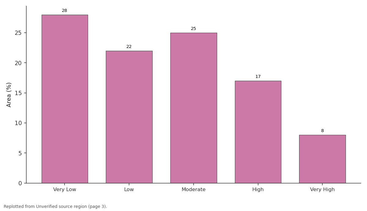
Area (%): Very Low vs Low vs Moderate vs High vs Very High
Replotted from a table (page 3) of the original paper. Every bar is the paper's own table value.
View source evidence ↗Introduction
Soil erosion is a globally recognized issue with severe consequences for food security, water supply and land sustainability. In India, watersheds across northwestern states like Haryana and Punjab are under constant threat due to intensive agriculture and rainfall variability. The G-K watershed, drained by the seasonal Ghaggar River, supports dense rural populations that depend on agriculture for their livelihoods. Estimating soil erosion rates is essential for watershed management, land-use planning and conservation policy formulation. The Universal Soil Loss Equation (USLE), developed by Wischmeier and Smith (1978) [1] , remains one of the most reliable models for predicting soil loss at watershed scales. Recent advances in geospatial technologies such as satellite-based land cover analysis and DEM-based topographical assessments allow the integration of USLE with GIS, enabling spatially explicit erosion mapping. This paper aims to estimate soil erosion across the G-K watershed using a GIS-based USLE approach, identify erosion hotspots and suggest land management practices to mitigate degradation. The widespread soil erosion issues have an impact on both emerging and wealthy nations. The effects of soil erosion, sometimes known as "soil cancer," are extensive, having negative effects on the economy, politics, society and environment. They also pose a growing threat to human existence on Earth (Pandey et al., 2007) [2] . According to estimates, considerable soil erosion affects more than 50% and 80% of the world's forest and agricultural land, respectively.
India is the second-most populous nation in the world despite having only 2.4% of the planet's total land area. About 5,334 metric tonnes of soil are eroded annually by various erosion processes throughout about 53% of the entire land area. One of the most important and precious resources on earth, soil is crucial for the health of ecosystems and is a key natural resource for sustaining life. The complicated and dynamic process of soil erosion results in the separation, transportation and deposit of surface soil to a distant location, ultimately exposing and degrading rich soils and causing sedimentation in reservoirs. early 20th century saw the introduction of the phrase "soil erosion". Background soil erosion is a natural process where soil is eroded by the action of various forces such as water or wind. The earth itself is as old as natural soil erosion. In the case of natural soil erosion, the rate of soil creation equals the rate of soil loss. However, where the rate of soil loss is far higher than its creation, rapid soil erosion has been recognised as a serious issue. Human actions that are illconsidered and unplanned frequently promote soil erosion.
Review of Literature
Numerous studies have highlighted the application of the Universal Soil Loss Equation (Wischmeier & Smith, 1978) and its variants (RUSLE, MUSLE) for erosion modeling in India. Jain et al. (2001) [2] successfully applied USLE-GIS in the Himalayan region for prioritizing sub-watersheds. Similarly, Yadav and Mathur (2017) [3] demonstrated effective mapping of erosion-prone zones using remote sensing and GIS in Rajasthan. These studies underscore the usefulness of GIS-based modeling in providing spatially distributed erosion estimates for sustainable watershed management. However, limited research exists for the G-K watershed, particularly integrating field-verified parameters with GIS models. This study will bridge that gap. The literature reveals a multi-faceted relationship between the Ghaggar River watershed and the lives of local communities. While the river remains an essential resource for agriculture and domestic use, its seasonal and polluted nature has become a source of vulnerability especially for children's education and well-being. There is a clear research gap in the integration of watershed science with educational and social impact analysis. Future studies must adopt interdisciplinary approaches, combining hydrological modeling, field surveys and socio-educational assessments to offer holistic watershed development strategies.
Study Area Description
The G-K watershed is located in northwestern India, encompassing parts of Fatehabad, Sirsa and Karnal districts. It lies between 29°30'N to 30°20'N latitude and 75°30'E to 76°50'E longitude, covering approximately 3,000 km². The region exhibits a semi-arid climate with an average annual rainfall of 500-800 mm, most of which occurs during the monsoon season. Topography ranges from flat plains to gently undulating terrain, with elevations between 200-300 meters above sea level. Land use is dominated by agriculture, primarily wheat, cotton and mustard crops, along with patches of fallow land and sparse vegetation. Soil types include sandy loam, loamy sand and alluvial soils prone to erosion, especially under intensive cultivation and poor conservation practices Watershed Name: G-K (Ghaggar-Karnal) Watershed
P-Factor
Assigned values based on land use practices (e.g., agriculture with no bunding = 1.0; terraced land = 0.5). 4.3 GIS Integration All thematic layers were prepared using ArcGIS 10.8 and QGIS 3.24. Raster multiplication of R, K, LS, C and P factors yielded the final soil erosion map.
Results and Discussion
Results and Discussion
Estimated Soil Loss
The estimated soil erosion in the G-K watershed ranges from 0.1 to 60 tons/ha/year, with the mean value around 15 tons/ha/year. The area was classified into five categories: and grasslands near the Ghaggar floodplains.
Critical Sub-Watersheds
Based on erosion values and slope characteristics, three subwatersheds were prioritized for conservation: SW1: Erosion > 45 t/ha/yr; requires check dams and afforestation. SW3: Erosion 30-40 t/ha/yr; suitable for contour bunding. SW5: Moderate erosion; recommend vegetative hedgerows and crop rotation.
Conclusion
This study provides scientific insights into soil degradation patterns in the G-K watershed and aid policy makers, agricultural planners and local communities in implementing effective erosion control measures. It also showcases the applicability of modern geospatial tools in regional land degradation assessment. The integration of USLE with GIS and RS techniques provided a comprehensive estimate of soil erosion in the G-K watershed. The findings show significant spatial variability in erosion rates, influenced by land use, slope and conservation practices. The identification of erosion-prone sub-watersheds offers valuable insights for targeted interventions such as afforestation, bunding and sustainable farming practices. This study contributes to effective watershed management and soil conservation planning in vulnerable regions of India.
Recommendations
Implement soil and water conservation structures in high-risk zones. Promote agroforestry and cover crops in erosion-prone farmlands. Encourage capacity-building programs for farmers on soil health. Regular monitoring of erosion trends using updated satellite data.
References
10 in the original paper- Wischmeier WH, Smith DD. Predicting rainfall erosion losses. USDA Handbook No. 537. Washington, DC: United States Department of Agriculture; 1978. p. 1-58.
- Jain MK, Das D, Sharma SK, Dabral PP, Pandey A, Nangia V, et al. Soil erosion assessment using GIS. J Soil Water Conserv. 2001;56(5):324-328.
- Yadav S, Mathur A. Soil erosion risk mapping using USLE in arid region of India. Remote Sens Appl. 2017;7:53-62.
- Sharma MK. Agricultural soil and sustainability: challenges and opportunities. Int J Agric Food Sci. 2024;6(1):101-106.
- Ali AA, Al-Abbadi AM, Jabbar FK, Alzahrani H, Hamad S, Ahmed HJ, et al. Predicting soil erosion rate at transboundary sub-watersheds in Ali Al-Gharbi, Southern Iraq, using RUSLE-based GIS model. Sustainability. 2023;15(3):1776-1794.
- Kheir RB, Abdallah C, Khawlie M. Assessing soil erosion in Mediterranean karst landscapes of Lebanon using remote sensing and GIS. Eng Geol. 2008;99(34):239-254.
- Kundu S. Heavy metal pollution of Ghaggar river in upper reaches. Bull Environ Pharmacol Life Sci. 2012;1(2):7-10.
- Pareek RK, Khan AS, Srivastva P, Roy S. Assessment of physicochemical properties of Ghaggar river. J Biol Chem Chron. 2018;4(1):19-25.
- Shrestha S, Kazama F. Assessment of surface water quality using multivariate statistical techniques: A case study of the Fuji river basin, Japan. Environ Model Softw. 2007;22(4):464-475.
- Venkatesharaju K, Somashekar RK, Prakash KL. Study of seasonal and spatial variation in surface water quality of Cauvery river stretch in Karnataka. J Ecol Nat Environ. 2010;2(1):1-9.