
Research article · 2025 · Full text
International Journal of Agriculture and Food Science3D virtual reality and image processing in landscape design
Volume 7(4) · Pages 251–253 · DOI: 10.33545/2664844x.2025.v7.i4d.359 ↗
Research areas3D Modeling in Geospatial Applications3D Surveying and Cultural Heritage
Abstract
Author-writtenSimulating the outcomes of landscape planning is a vital step in ensuring thoughtful and effective design. Traditional simulation systems often fall short in flexibility and visual fidelity. To overcome these limitations, this study introduces an innovative virtual reality-based simulation system for landscape planning. The system architecture includes three layers: user, application, and display. Based on this structure, essential hardware components such as display units, control modules, and data acquisition devices are selected, and the system software is designed to support core operations seamlessly. This paper also explores a landscape design system powered by 3D image processing techniques. By enhancing image quality and removing unnecessary visual data, the design process becomes clearer and more precise. Using a case study of a garden green space, plant morphological data is collected and used to generate accurate 3D models through parametric modeling. The integration of Oculus Rift and the Open Scene Graph rendering engine allows for immersive visualization and spatial arrangement of landscape elements in virtual environments. The approach has proven effective, delivering high-quality, visually compelling designs while remaining cost-effective and energy-efficient.
Summary
Source-checkedPlain-language reading of the full paper, prepared with AI and checked against the text. Each point links to the authors' own words.
Why it matters
- Simulating landscape planning outcomes is essential for creating effective and thoughtful designs. View evidence ↗
- Conventional simulation systems are often limited by their lack of visual fidelity and flexibility. View evidence ↗
- Traditional landscape design methods frequently fail to effectively communicate the final result to stakeholders or clients. View evidence ↗
The question
- The study aims to develop a 3D virtual imaging system that connects the initial design vision with the actual execution of landscape planning. View evidence ↗
- The research seeks to create a reliable platform for future projects by streamlining the design process and improving technological integration. View evidence ↗
What they did
- The proposed simulation system is built on a three-layer architecture consisting of the user, application, and display layers. View evidence ↗
- The researchers used a garden green space case study, collecting plant morphological data to create accurate 3D models via parametric modeling. View evidence ↗
- Immersive visualization and spatial arrangement were achieved by integrating the Open Scene Graph rendering engine with Oculus Rift. View evidence ↗
- Digital 3D models were constructed using software tools including AutoCAD, Lumion, or Sketch Up. View evidence ↗
What they found
- The implemented approach produced high-quality and visually compelling designs while maintaining energy efficiency and cost-effectiveness. View evidence ↗
- Stakeholder feedback was primarily positive, specifically highlighting the clarity and realism of the resulting design. View evidence ↗
- The resulting design was found to be practical and consistent with standard construction techniques. View evidence ↗
What it means
- The authors conclude that integrating virtual reality and 3D imaging is an effective method for landscape design. View evidence ↗
- Case studies confirmed that the system provides high-quality output with low operational costs. View evidence ↗
- The authors note that challenges persist regarding the refinement of data analysis methods and ensuring the system is applicable across a wider variety of garden types. View evidence ↗
- Future research will focus on expanding the range of applicable landscape scenes and exploring species-specific distribution modeling. View evidence ↗
Visual summary
1 visualsIllustrations explain the paper; they do not show study data.
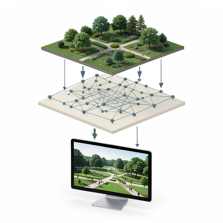
System Architecture Layers
AI-generated conceptual illustration (A virtual reality landscape design software system). It explains the idea and does not show study data.
View source evidence ↗Introduction
With advancements in construction technology, landscaping has evolved from a secondary consideration to a core part of architectural design. A well-designed garden or landscape speaks volumes about the quality and intent behind a project. Generally, landscape designs fall into two categories: conceptual experiences and actual physical scenes. However, traditional methods often struggle to convey the end result effectively to clients or stakeholders. Today, 3D virtual imaging has become a standard tool in architectural presentations, allowing for realistic visualization of design concepts. This paper proposes a 3D virtual imaging system to bridge the gap between vision and execution in landscape planning. It aims to streamline the design process, enhance technological integration, and offer a reliable platform for future landscape projects. As ecological awareness grows, so does the demand for sustainable and interactive design. With the development of 3D virtual reality (VR) and advanced image processing, architects and designers are now able to create immersive experiences that allow clients to engage with the landscape in real time. The paper introduces an interactive roaming design method that blends VR and image processing, bringing to life various landscape features such as buildings, vegetation, and water bodies with artistic depth and realism.
Literature Review 2.1 3D VR-Based Landscape Design Systems:
This system combines 3D image processing and virtual reality to simulate landscape planning. With user-friendly architecture and noise-reduction techniques, it creates lifelike plant models and immersive environments using Oculus Rift and Open Scene Graph. Case studies confirm its high-quality output and low operational cost.
3D Visualization in Education
This study highlights the use of software like AutoCAD, 3D Max, and SketchUp in landscape design education. It emphasizes the shift from 2D to 3D learning and supports full-process design education with theoretical and hands-on training.
VR in Urban Plant Configuration
Using 3DSMAX and level-of-detail algorithms, this research improves visual realism while optimizing system performance. It proves effective for rendering large-scale scenes without data overload.
Urban Green Space Optimization
Utilizing GIS and remote sensing, this study uses 3D simulations to optimize green space layouts. It finds that well-planned green areas can increase public accessibility and utility significantly.
IoT in 3D Urban Landscape Design
By transforming 2D layouts into interactive 3D reconstructions, this research improves the speed and accuracy of urban design planning. The real-time data integration helps with cost estimation and project execution.
Proposed Methodology
Proposed Methodology
3D Modeling & Design Development
Use tools such as Sketch Up, Lumion, or AutoCAD to build digital 3D models. Adjust terrain and elevation based on real topography. Add plants, outdoor furniture, lighting, and other key elements.
Texture, Material, and Rendering
Apply realistic textures for materials like stone, wood, water, and grass. Use rendering engines (e.g., V-Ray, Twin motion) for photorealistic visuals. Simulate weather effects and different seasons for realism.
Walkthroughs & VR Integration
Develop animated walkthroughs to demonstrate the landscape from multiple perspectives. Implement VR or AR tools to create immersive experiences for clients.
Design Evaluation & Modifications
Gather client input and make iterative changes. Optimize the design for sustainability and maintenance.
Final Presentation & Documentation
Prepare high-quality visuals and documentation. Export files in appropriate formats for construction and presentation.
Implementation & Monitoring
Collaborate with contractors during project execution. Monitor progress and update the design as necessary.
Results and Discussion
4.1 Overview of the 3D Landscape Design The final model features realistic terrain, plants, water features, and site furniture. The design meets the project's functional, visual, and ecological goals.
Visual and Aesthetic Analysis
Effective use of materials and lighting enhances realism. Seasonal variations and color schemes enrich the visual quality.
Functional and Spatial Organization
Spaces are well-organized for accessibility and usability. Includes clearly defined walkways, seating areas, and recreational spaces.
Environmental and Sustainability Considerations
Eco-friendly materials and energy-efficient lighting are used. Incorporates rainwater management and lowmaintenance plantings.
Rendering and Visualization Quality
High-quality renderings and walkthroughs clearly communicate design intent. Comparisons between rendering software show varied effectiveness.
4.6
Client/Stakeholder feedback and design modifications Feedback was mostly positive, emphasizing the realism and clarity of the design. Minor layout adjustments were made based on stakeholder input.
Implementation Feasibility
The design is practical and aligns with standard construction techniques. Anticipated challenges include terrain grading and plant sourcing.
Conclusion
This research demonstrates the effectiveness of using 3D imaging and virtual reality in landscape design. By integrating SURF feature matching and real-time image capture, the system reconstructs landscape scenes with improved accuracy and clarity. The results highlight the potential of these technologies to serve as a scientific reference for rational garden layout and planning. However, challenges remain, particularly in ensuring broader applicability across various garden types and refining data analysis methods. Future work will involve deeper exploration into species-specific distribution modeling and expanding the range of applicable landscape scenes. Continued advancements in 3D modeling and data mining will further enhance the effectiveness and efficiency of landscape design tools, contributing to sustainable development in the landscaping industry.
References
15 in the original paper- Shen H, Wang J, Li X. Research on landscape design system based on 3D virtual reality and image processing technology. Ecological Informatics. 2021;63:01287.
- Gill L. A 3D landscape information model. University of Sheffield, White Rose E-Theses Online, 2013.
- Zhou Y, Wang L. Research on 3D urban landscape design and evaluation based on geographic information system. Geographic Information Sciences Journal. 2021;45(3):145-163.
- Liu X, Li Optimization of urban green space landscape pattern and 3D numerical simulation. EAI Endorsed Transactions on Smart Cities. 2023;7(24):e2330629.
- Wang X, Chen H. Design of the 3D digital reconstruction system of an urban landscape spatial pattern based on the Internet of Things. International Journal of Digital Innovation in Smart Cities. 2023;4(2):75-92.
- Li J, Zhang M. Application of 3D visualization in landscape design teaching. International Journal of Emerging Technologies in Learning. 2022;17(3):78-94.
- Yang C, Xu R. TreeSketchNet: From sketch to 3D tree parameters generation. Computer Vision and AI in Landscape Modeling. 2022;29(5):315-329.
- Zhang F, Liu J. AI-Aided greenspace design using generative adversarial networks. Landscape Architecture and Computation. 2024;32(1):50-67.
- Paar P, Clasen M. Earth, Landscape, Biotope, Plant: Interactive Visualization with Biosphere3D. CORPCompetence Center of Urban and Regional Planning, 2007.
- Sheppard SRJ, Cizek P. The Ethics of Google Earth: Crossing Thresholds from Spatial Data to Landscape Visualization. Journal of Environmental Management. 2009;90(6):2102-2117.
- Clasen M. Towards interactive landscape visualization. Doctoral Dissertation, Technische Universität Dresden, 2011.
- Gastellu-Etchegorry JP, Demarez V, Pinel V, Zagolski F. Modeling Radiative Transfer in Heterogeneous 3-D Vegetation Canopies. Remote Sensing of Environment. 1996;58(2):131-156.
- Gascon F, Etchegorry GJP, Lefèvre MJ. Radiative Transfer model for simulating high-resolution satellite images. IEEE Transactions on Geoscience and Remote Sensing. 2001;39(9):1922-1926.
- Pinty B, Gascon F, Etchegorry GJP. The Radiation Transfer Model Intercomparison (RAMI) Exercise. Journal of Geophysical Research: Atmospheres. 2001;106(D11):11937-11956.
- Couturier S, Etchegorry GJP, Martin E, Patiño P. Building a forward-mode 3-D reflectance model for topographic normalization of high-resolution (1-5m) Imagery: Validation Phase in a Forested Environment. IEEE Transactions on Geoscience and Remote Sensing. 2012;51(7):3910-3921.