
Research article · 2024 · Full text
International Journal of Geography Geology and EnvironmentStatus of ground water development in Western Haryana, India
Volume 6(2) · Pages 112–116 · DOI: 10.22271/27067483.2024.v6.i2b.293 ↗
Research areasWater resources management and optimizationGroundwater and Watershed Analysis
Abstract
Author-writtenIn the last few decades, groundwater has emerged as an important resource for agriculture and food security in India, with Haryana being considerably dependent on its underground reserves. Irrigated area has increased and in Western Haryana, the groundwater extraction has gone upto 132.17 %. However, this groundwater development is at different stages for different blocks of the region. Only in 11 blocks the groundwater levels are
Summary
Source-checkedPlain-language reading of the full paper, prepared with AI and checked against the text. Each point links to the authors' own words.
Why it matters
- Groundwater is a critical resource for food security and agriculture in India, and the state of Haryana relies heavily on these underground reserves. View evidence ↗
- The number of tubewells in Haryana increased nearly thirty-fold between 1966 and 2013, growing from 0.2 million to 0.73 million. View evidence ↗
- Western Haryana has overexploited its groundwater, with an extraction stage of 132.17% as of 2023. View evidence ↗
The question
- The study aims to determine the overall stage of groundwater development across blocks in Western Haryana and identify the number of over-exploited blocks to highlight conservation needs. View evidence ↗
What they did
- The research focused on 42 blocks across six districts in Western Haryana: Sirsa, Fatehabad, Hisar, Bhiwani, Charkhi-Dadri, and Mahendragarh. View evidence ↗
- Groundwater status was categorized as 'over-exploited' (extraction exceeds recharge), 'critical' or 'semi-critical' (high stress), or 'safe' (sustainable extraction). View evidence ↗
What they found
- Approximately 57% of the blocks in Western Haryana are 'over-exploited,' meaning extraction levels are above 100%. View evidence ↗
- Between 2020 and 2022, several blocks experienced changes in their groundwater status, with some improving to safer categories and others deteriorating into critical or over-exploited categories. View evidence ↗
What it means
- The authors conclude that policymakers and stakeholders must implement targeted conservation and replenishment measures in over-exploited areas to ensure a sustainable future water supply. View evidence ↗
- The authors highlight a stark contrast in the region, where 11 blocks are safe but 24 over-exploited blocks face a potential water crisis. View evidence ↗
Visual summary
1 visualsIllustrations explain the paper; they do not show study data.
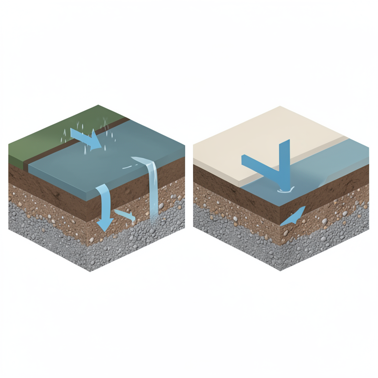
Groundwater Categorization Logic
AI-generated conceptual illustration (an underground aquifer in a rural agricultural landscape). It explains the idea and does not show study data.
View source evidence ↗Figures & tables
From the original paper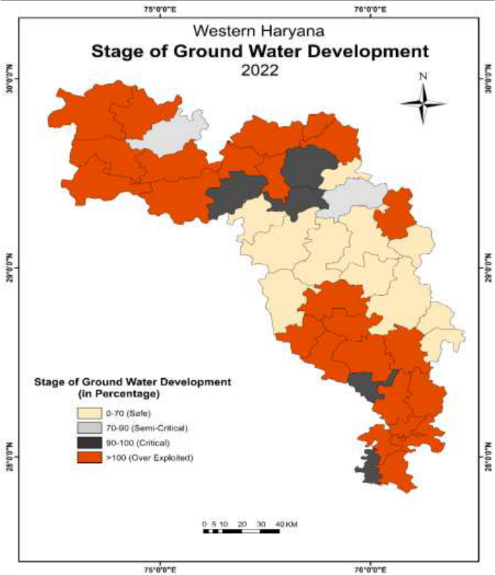 Figure 2
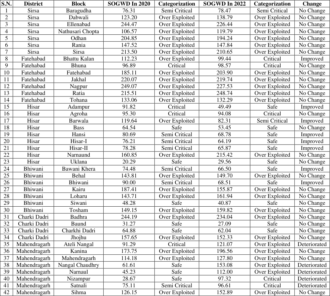 Table 1
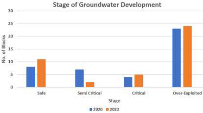 Figure 3
Introduction
Haryana is one of the most developed agricultural states of India. It is also one of the leading state in the country with reference to groundwater based irrigation development and water supply. Available data and projections reveal a rapid increase in the area irrigated by groundwater, along with a significant rise in the number of wells and energized pump sets. The different hydrogeological characteristics of the state results in regional variations of groundwater potential. In the period of 1965-68, canals constituted the leading source of irrigation and covered around 78 percent of the irrigated area. However, their contribution to irrigation has gradually declined since the advent of tubewell irrigation (Sharma, 2020). Tube wells in the state have risen from a mere 0.2 million in 1966 to 0.73 million in 2013, i.e., nearly thirty times. Even though groundwater irrigation has expanded rapidly all over the state in the intervening years, it has also brought about adverse effects on the state's groundwater resources (Singh & Amrita, 2017) [7] . Western Haryana is also highly dependent on groundwater resources. The stage of groundwater extraction in western Haryana is 132.17 percent (CGWB, 2023). This stage of groundwater extraction clearly indicates that there has been overexploitation of this precious resource and there is an urgent need for its management and conservation. This study focuses on the groundwater development in the 42 blocks of Western Haryana. Understanding of the present scenario of groundwater resources is very important. Increasing requirements for agricultural, industrial, and domestic uses necessitate planned development of groundwater. Water being indispensable to all life forms and highly decreased in availability, the economical and equitable use of this resource for sustenance of ecological balance is required. In order to address, the issues of water scarcity, increased demand, and reduced ground levels, effective development and management of water resources is the need of the hour (Nagaraja, 2018) [5] .
Study area
Astronomically, the western part of Haryana lies between 27°49ʹ 08\" North to 29°58ʹ50" North latitudes and from 74°28ʹ 18" East to 76°27ʹ7" East longitudes. The area is generally dry, semi-arid in terms of climatic conditions, and the Aravalli hills extend into the southern portion that stretches up to Bhiwani. In this study area, modern farming technologies have been adopted on large scale and almost all the district mainly consists of homogeneous agricultural landscapes. This zone comprises of six districts: Sirsa, Fatehabad, Hisar, Bhiwani, Charkhi-Dadri, and Mahendragarh and these are further divided into 42 blocks. The altitude across this section of Haryana ranges from 220 to 235 meters above mean sea level (MSL). It forms a part of the alluvial Ghaggar-Yamuna plain, whereas the southern as well as the western portion gradually merges with Thar Desert.
Data and methodology
The present study deals with the western parts of the Haryana. Blocks are considered as study unit and the data considered for this study is secondary in nature. The data of years 2020 and 2022 is used for studying the stages of groundwater development. The data and information is collected from the Central Ground Water Board, Chandigarh. The base map has been prepared with the help of ArcGIS software. Such classifications connote much, as these will determine agricultural activities, socio-economic status, and the sustainability of the environment. Over-exploited and critical areas typically suffer at the agricultural level due to falling water tables, decreased crop yields, and farmer distress. Moreover, the degradation of groundwater in saline areas poses various health concerns and restricts the usability of water for varied purposes, affecting the wellbeing of the community (Adimalla & Qian, 2020) [1] . These categories are shown in Map 2 and Table 1 and are discussed in detail below:
| S.N. | District | Block | SOGWD In 2020 | Categorization | SOGWD In 2022 | Categorization | Change |
|---|---|---|---|---|---|---|---|
| 1 | Sirsa | Baragudha | 76.31 | Semi Critical | 78.47 | Semi Critical | No Change |
| 2 | Sirsa | Dabwali | 123.20 | Over Exploited | 138.79 | Over Exploited | No Change |
| 3 | Sirsa | Ellenabad | 244.47 | Over Exploited | 226.44 | Over Exploited | No Change |
| 4 | Sirsa | Nathusari Chopta | 106.57 | Over Exploited | 119.79 | Over Exploited | No Change |
| 5 | Sirsa | Odhan | 204.85 | Over Exploited | 194.24 | Over Exploited | No Change |
| 6 | Sirsa | Rania | 147.52 | Over Exploited | 147.84 | Over Exploited | No Change |
| 7 | Sirsa | Sirsa | 213.50 | Over Exploited | 210.65 | Over Exploited | No Change |
| 8 | Fatehabad | Bhattu Kalan | 112.23 | Over Exploited | 99.44 | Critical | Improved |
| 9 | Fatehabad | Bhuna | 96.89 | Critical | 98.57 | Critical | No Change |
| 10 | Fatehabad | Fatehabad | 185.11 | Over Exploited | 203.90 | Over Exploited | No Change |
| 11 | Fatehabad | Jakhal | 220.07 | Over Exploited | 219.74 | Over Exploited | No Change |
| 12 | Fatehabad | Nagpur | 249.07 | Over Exploited | 227.53 | Over Exploited | No Change |
| 13 | Fatehabad | Ratia | 215.51 | Over Exploited | 248.74 | Over Exploited | No Change |
| 14 | Fatehabad | Tohana | 133.06 | Over Exploited | 132.29 | Over Exploited | No Change |
| 15 | Hisar | Adampur | 91.82 | Critical | 49.49 | Safe | Improved |
| 16 | Hisar | Agroha | 95.30 | Critical | 94.08 | Critical | No Change |
| 17 | Hisar | Barwala | 119.64 | Over Exploited | 82.31 | Semi Critical | Improved |
| 18 | Hisar | Bass | 64.54 | Safe | 53.45 | Safe | No Change |
| 19 | Hisar | Hansi | 80.69 | Semi Critical | 68.78 | Safe | Improved |
| 20 | Hisar | Hisar-I | 76.21 | Semi Critical | 64.19 | Safe | Improved |
| 21 | Hisar | Hisar-II | 78.28 | Semi Critical | 65.87 | Safe | Improved |
| 22 | Hisar | Narnaund | 160.85 | Over Exploited | 215.42 | Over Exploited | No Change |
| 23 | Hisar | Uklana | 20.29 | Safe | 29.56 | Safe | No Change |
| 24 | Bhiwani | Bawani Khera | 74.48 | Semi Critical | 66.50 | Safe | Improved |
| 25 | Bhiwani | Behal | 143.81 | Over Exploited | 149.70 | Over Exploited | No Change |
| 26 | Bhiwani | Bhiwani | 90.00 | Semi Critical | 68.51 | Safe | Improved |
| 27 | Bhiwani | Kairu | 187.41 | Over Exploited | 155.87 | Over Exploited | No Change |
| 28 | Bhiwani | Loharu | 143.71 | Over Exploited | 161.94 | Over Exploited | No Change |
| 29 | Bhiwani | Siwani | 48.28 | Safe | 40.87 | Safe | No Change |
| 30 | Bhiwani | Tosham | 149.15 | Over Exploited | 159.82 | Over Exploited | No Change |
| 31 | Charki Dadri | Badhra | 244.19 | Over Exploited | 234.04 | Over Exploited | No Change |
| 32 | Charki Dadri | Baund | 31.27 | Safe | 27.09 | Safe | No Change |
| 33 | Charki Dadri | Charkhi Dadri | 64.88 | Safe | 62.04 | Safe | No Change |
| 34 | Charki Dadri | Jhojhu | 157.65 | Over Exploited | 152.33 | Over Exploited | No Change |
| 35 | Mahendragarh | Ateli Nangal | 91.29 | Critical | 121.07 | Over Exploited | Deteriorated |
| 36 | Mahendragarh | Kanina | 173.75 | Over Exploited | 196.56 | Over Exploited | No Change |
| 37 | Mahendragarh | Mahendragarh | 114.18 | Over Exploited | 127.80 | Over Exploited | No Change |
| 38 | Mahendragarh | Nangal Chaudhry | 61.61 | Safe | 153.08 | Over Exploited | Deteriorated |
| 39 | Mahendragarh | Narnaul | 45.23 | Safe | 112.00 | Over Exploited | Deteriorated |
| 40 | Mahendragarh | Nizampur | 28.67 | Safe | 97.32 | Critical | Deteriorated |
| 41 | Mahendragarh | Satnali | 75.11 | Semi Critical | 96.61 | Critical | Deteriorated |
| 42 | Mahendragarh | Sihma | 126.15 | Over Exploited | 152.89 | Over Exploited | No Change |
Table text extracted from the original PDF; superscript letters are shown inline. The original table image is below.
View original table image
SAFE
Only eleven blocks in Western Haryana are classified as "safe." There isn't a safe block in the districts of Mahendragarh, Fatehabad, and Sirsa. The 'Safe' classification for blocks like Adampur, Bass, Hansi, Hisar-I, Hisar-II, Uklana, Bawani Khera, Bhiwani, Siwani, Baund, and Charkhi Dadri indicates that these blocks have better groundwater supply than other blocks. The percentage values in this category vary between 0-70. This assessment is essential for developing plans for managing water resources, with a particular focus on areas that require immediate attention and conservation measures due to acute water stress.
Semi-Critical
In Western Haryana, this is the third prominent category in the groundwater development stage. With percentage levels between 70 and 90 percent, only two blocks-Barwala in the district of Hisar and Baragudha in the district of Sirsa-fit into the "Semi-Critical" category, indicating a moderate degree of water stress.
Critical
Five blocks-Bhattu Kalan and Bhuna in the Fatehabad district, Agroha in the Hisar district, Nizampur and Satnali in the Mahendragarh district-are deemed "critical" due to the fact that their percentage values fall between 90 and 100, indicating that the water level is approaching an alarmingly low level.
Over exploited
Blocks in western Haryana that are overexploited make up about 57% of the total. In the districts of Sirsa, Fatehabad, Bhiwani, and Mahendragarh, this category is predominant. 'Over-Exploited' blocks include Bahal, Kairu, Loharu, Tosham, Badhra, Jhojhu, Bhattu Kalan, Fatehabad, Jakhal, Ratia, Tohana, Barwala, Mahendragarh, Rania, Sirsa, etc. because their percentage values suggest that the amount of water extracted is alarmingly high-above 100. There's a big chance that there won't be adequate water supply in these blocks in the near future. Figure 3 shows that many blocks witnessed a change in the groundwater development stage category between 2020 and 2022. Some improved and went into safer categories, while some worsened and went into more critical and overexploited categories. Others have stood their ground with stability regarding the use of groundwater in those blocks.
Conclusion
In conclusion, the classification of groundwater into several categories constitutes one of the excellent steps toward sustainable management of the water resource. Targeted measures taken by policymakers and stakeholders with welldefined areas facing over-exploitation or depletion towards the conservation and replenishment of groundwater resources are meant to understand the criteria and implications in each category, which will lead to a strategy that manages stress of water while ensuring safe and sustainable supply of groundwater in the future. This data is crucial for water resource management and conservation strategies to address the water stress in different regions of Haryana. There are 11 safe blocks, indicating a safer level of groundwater availability and on the other extreme are the 24 over exploited blocks which show a bleak future and water crisis.
Figures and tables from the paper
References
6 in the original paper- Adimalla N, Qian H. Spatial distribution and health risk assessment of fluoride contamination in groundwater of Telangana: A state-of-the-art. Geochemistry. 2020;80(4). DOI: 10.1016/j.chemer.2019.125548.
- Central Ground Water Board (CGWB). Dynamic Ground Water Resources of Haryana State (As On 31st March 2022). Ground Water Cell, Irrigation & Water; 2023.
- Central Ground Water Board (CGWB). Dynamic Ground Water Resources of India (As on March 2017). Ministry of Jal Shakti, Government of India; c2019.
- Nagaraja PV. Identification and delineation of groundwater potential zones in and around Rajampet by using remote sensing and GIS techniques. Journal of Emerging Technologies and Innovative Research. 2018;634-648.
- Sharma P. Status of groundwater resources in Haryana and its dynamics and spatial pattern. Palarch's Journal of Archaeology of Egypt/Egyptology. 2020;17(5).
- Singh O, Amrita. Dynamics and economy of groundwater resources in Haryana. Punjab Geographer. 2017;129-132.
Cited by 1
From OpenAlex, OpenCitations and reference lists read by Scinovex
- Gypsum and press mud application alleviate the deleterious effects of sodic water irrigation in Guava (Psidium Guajava L. cv. Taiwan Pink) ↗
Akshay Machra, Raj Kumar, Anshuman Singh, Daya Shankar Mishra, Priyanshu J. Patel, Nirmal Singh et al. · BMC Plant Biology · 2025
Guava is a major fruit crop in sodic soil regions of north-western India. However, the responses of guava to sodic irrigation in terms of growth, physiology, and fruit quality remain elusive. This study evaluated the effects of sodic irrigation with varying residual sodium carbonate (RSC; 2.5-7.5 meq L⁻¹), with or without amendments (gypsum and press mud), on the growth, physiological…
❝ 2PDF