
Research article · 2023 · Full text
International Journal of Geography Geology and EnvironmentRockfall hazard evaluation in Sargalu village: North of Iraq
Volume 5(2) · Pages 60–67 · DOI: 10.22271/27067483.2023.v5.i2a.176 ↗
Research areasLandslides and related hazardsEarthquake Detection and Analysis
Abstract
Author-writtenThe current study was selected due to the importance of studying rockfalls in the Sargalu village in northern Iraq, which is considered one of the tourist areas in the region. Sargalu is situated in the northeast limp of the Sordash anticline. The significance of this study lies in assessing the risks associated with these rockfalls and identifying appropriate preventive and corrective measures to achieve these objectives. The Rockfall Hazard Rating System (RHRS) was applied in this study to evaluate the risks of rockfalls in the area since there were no previous studies on this area. The RHRS relies on a set of criteria and indicators to determine the risk level in the area. Detailed geological, geotechnical, and geological engineering studies were conducted to identify the types of rockfalls present in the area.The geological study of the area revealed the exposure of the following geological formations from oldest to youngest: Sargalu, Nawkalikan, Barsarin and ChiaGara. Tectonically, the area is located at the beginning of the High Folded Zone, which is part of the tectonic regions of Iraq. This geological setting makes it susceptible to recent tectonic deformations related to the Alpine movement.The study on rockfall hazard estimation was classified as high-risk slopes. Kinematic analysis using the Dips software revealed that there is a possibility of planar sliding, wedge sliding, and direct toppling failures. The study concludes that the study area requires warning signs, speed restrictions on the road, daily road monitoring, and some treatments to avoid the effects of rockfalls. Additionally, detailed studies of the slopes are recommended.
Summary
Source-checkedPlain-language reading of the full paper, prepared with AI and checked against the text. Each point links to the authors' own words.
Why it matters
- Analyzing rockfalls on slopes next to roads is a critical task in geological engineering. View evidence ↗
- Sargalu village in northern Iraq is a significant tourist area, making the study of its rockfall hazards particularly important. View evidence ↗
- Rockfalls are defined as the downward movement of rock masses on mountain slopes driven by gravity, hydrodynamic pressure, and seismic events. View evidence ↗
The question
- The primary goal of the study is to assess rockfall risks and their extent to determine hazards for transportation and activities in the tourist area of Sargalu village. View evidence ↗
What they did
- The researchers used the Rockfall Hazard Rating System (RHRS) as the primary tool to evaluate and classify rockfall risks. View evidence ↗
- The study focused on an 88-meter section of road located on the northeast wing of the Sardash anticline in Sargalu village. View evidence ↗
What they found
- The RHRS evaluation for the study area resulted in a total of 402 points. View evidence ↗
- The slopes were classified as Level 2 risk; while one section of the text describes this as moderate, the conclusion explicitly classifies Level 2 as high risk. View evidence ↗
- The analyzed slope face is 88 meters long, faces 305 degrees, and has a steep angle between 70 and 90 degrees. View evidence ↗
- The slope face consists of the Qamchuqa Formation, featuring large dolomite rocks with layers 1 to 1.5 meters thick. View evidence ↗
What it means
- The authors conclude that the high-risk slopes require the installation of warning signs, speed limits, and daily road monitoring. View evidence ↗
- The authors recommend implementing proper water drainage management to reduce the likelihood of sliding and accidents. View evidence ↗
- The authors state that further detailed studies of the slopes are necessary to identify more effective risk mitigation measures. View evidence ↗
Figures & tables
From the original paper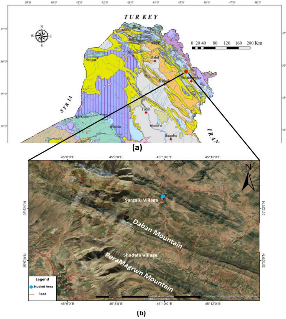 Figure 1
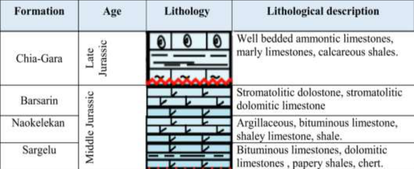 Figure 2
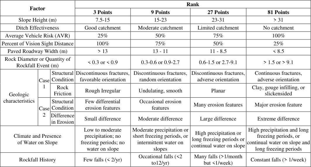 Table 1
 Table 2
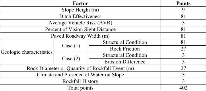 Table 3
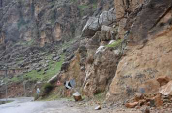 Figure 2
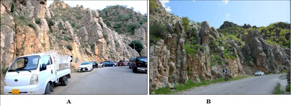 Figure 3
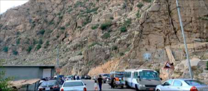 Figure 4
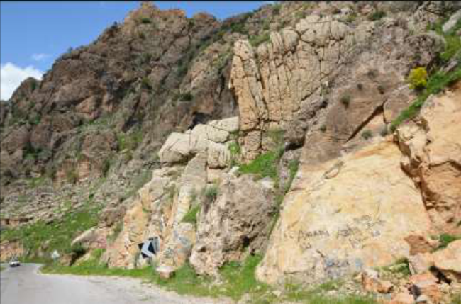 Figure 5
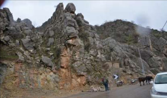 Figure 6
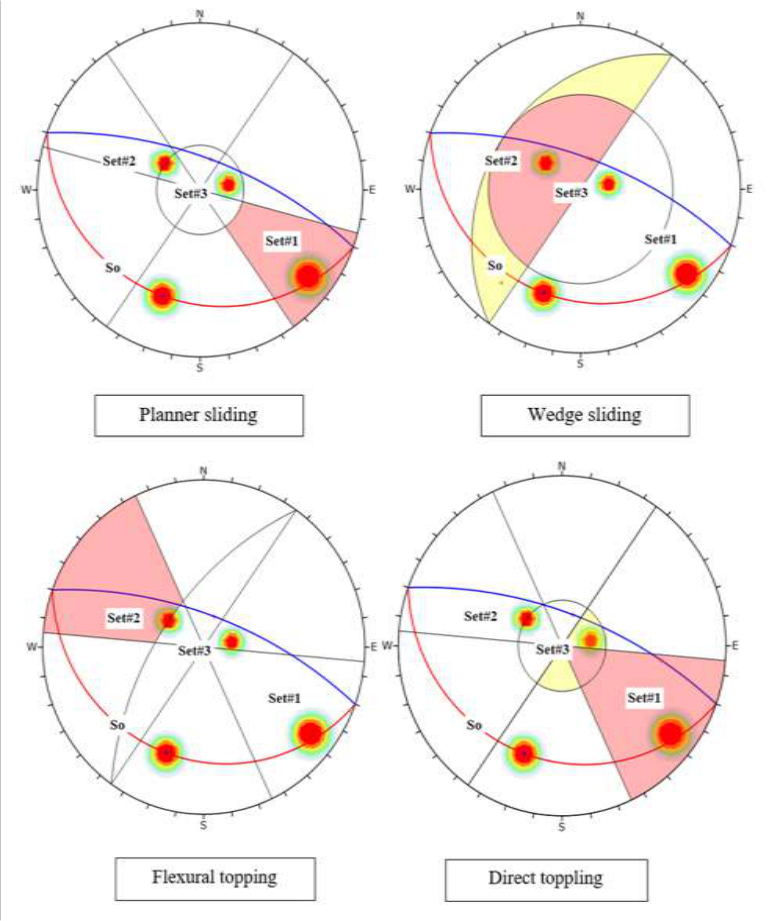 Figure 7
Introduction
Studying rockfalls in road-adjacent slopes is essential in the field of geological engineering. These rockfalls can occur due to human activities such as cutting and filling during road construction, as well as natural rockfalls caused by various factors, including seismic vibrations [1,2] . Rockfalls refer to the downward movement of rock bodies or rock masses on mountain slopes under the influence of gravity, hydrodynamic pressure, and other factors, including seismic events [3,4] , The phenomenon of rockfalls has significant geological and engineering implications for human life and the surrounding environment [5,6] . Stable rockfall locations can maintain their equilibrium and cohesion over short or long periods [7,8] . Understanding the conditions and factors leading to these rockfalls has been the focus of various studies to define them accurately for engineers and find stability solutions for the slopes. Building roads and highways in mountainous regions presents specific challenges for geologists and geotechnical engineers. The vast extent of these projects makes it difficult to gather sufficient information to assess the stability of all the slopes along the road. Consequently, most highway slopes are designed based on somewhat basic geotechnical analyses, mainly focusing on the general stability against sliding or major collapses that could jeopardize the operation of the roads [9] . Detailed analyses of rockfall hazards are rare, except in densely populated areas of highly developed countries like Switzerland. To address this issue, highway and railway administrations have developed classification schemes that can be implemented through visual inspection and simple calculations. The purpose of these classifications is to identify slopes that are particularly hazardous and require immediate remediation or further detailed study. Regarding rockfall hazard assessment, one widely accepted system is the Rockfall Hazard Rating System (RHRS). This system was initially developed by [10] and later modified by [11] . In this study, the RHRS was chosen as the primary tool to achieve the objective of comprehensive analysis and classification of rockfall-prone slopes.
The system relies on a set of criteria and variables associated with the slope, rock characteristics, surrounding terrain, and other relevant factors to assess and classify the rockfall hazard.
Aims of Study
The main aims of the current study can be summarized as follows:
1. The study aims to assess the risks of rockfalls and identify their extent to determine the hazards for transportation and activities in Sargalu village, considering its status as a tourist area. This assessment will be carried out using the Rockfall Hazard Rating System (RHRS).
Stratigraphy of the Study Area
Stratigraphy of the study area is one of the essential aspects that must be studied due to its significance in engineering studies. It involves the geological formations exposed on the surface and the recent deposits covering the region. Through studying these formations, the existing relationships between the rock types and their distribution can be understood along with the geological phenomena in the area. The impact of these formations on the variations in rock type and nature, which in turn influence the stability of slopes, can be determined. These formations, from the oldest to the most recent, are as follows.
Sargalu Formation (Middle Jurassic)
This formation consists of black continental limestone (bituminous limestones) and Dolomitic limestones, interbedded with brown papery shales, along with distinctive brownish chert zones in the upper part. The thickness of the formation in the study area ranges from 40 to 130 meters.
Naokelekan Formation (Middle Jurassic)
This formation consists of thin layers of argillaceous material and is covered by alternating thin layers of bituminous limestone, shaley limestone, and shale. The thickness of the Naokelekan Formation in the study area is approximately 20 meters.
Barsarin Formation (Middle Jurassic):
This formation mainly consists of stromatolitic dolostone, along with stromatolitic dolomitic limestone. The thickness of this formation in the study area is approximately 20 meters.
Chia-Gara Formation (Late Jurassic)
The formation consists of thin layers of limestone and marly limestone, characterized by its intermingling yellow color, along with calcareous shales that have a dark brown color and are rich in organic matter with an oily smell. The limestone is well-bedded and contains organic materials and ammonites. The thickness of the formation in the study area ranges from 100 to 200 meters.
Fig 2:
The stratigraphic column of formations presents in the study area.
Methodology
The research methods included several stages, which are as follows:
Field Work Stage
In this stage, several reconnaissance surveys were conducted in the study area to understand its geology, relying on topographic maps. A complete geological survey was carried out for the prevailing landslides in the study area. The assessment of these landslides' risks was performed using a global system called the Rockfall Hazard Rating System (RHRS) (Pierson, et al., 1990) Table (1). The area studied for specific elements and categories related to the RHRS to calculate the amount and nature of rockfall and the risks associated with these landslides in the study area.
The calculations include the following elements:
1. Describing the slope by measuring the Slope Height, the slope face, and the direction of inclination. 2. Evaluating the effectiveness of ditches (Ditch Effectiveness). 3. Assessing the average risk to vehicles (Average Vehicle Risk).
4. Determining the percent of Decision Sight Distance for visibility. 5. Measuring the roadway width, including paved shoulders. 6. Taking measurements of the geometrical dimensions of unstable or collapsed blocks within the slope. 7. Assessing the Geologic Character, which can be divided into two conditions. The first case: When structural geological conditions dominate the landslides, the evaluation includes the assessment of the structural geological conditions and the nature of discontinuity surfaces.
The second case: When geological conditions resulting from weathering and exposure dominate the landslides, the evaluation includes assessing variations in rock type and the degree of differential weathering. 8. Evaluating the size of the collapsed rock blocks (Block Size). 9. Identifying previous failure events (Previous Failures). 10. Assessing the climate and the presence of water on the slope (Climate and Presence of Water on Slope).
Table 1: Basic properties in the rock fall hazard rating system (RHRS) and their intensity rating according to (Pierson, et al, 1990).
Factor
Factor
Nature of Risks in Slopes Total points
Nature of Risks in Slopes Total points
Risk Level
Low-risk slopes / Slopes do not require detailed studies. 199 > Level 4
Moderate-risk slopes / Slopes require warning signs and routine monitoring along the road weekly.
399-200 Level 3
High-risk slopes / Slopes require warning signs, speed limit designation on the road, daily patrols, some treatments to avoid the effects of collapses, and recommendations for detailed slope studies. 599-400 Level 2
Very high-risk slopes / Vehicle traffic on the road is stopped, detailed studies of the slopes are conducted, measuring the nature of occurring and potential collapses, and direct intervention to address potential collapses. 600 ≤ Level 1
Evaluation of Failures Hazards at Study Area
The study area is considered one of the roads that was constructed by cutting and filling operations, which disturbed the natural balance of the slopes, resulting in landslides occurring in various parts of the slopes overlooking the road. In this study, the Rockfall Hazard Rating System (RHRS) was used to assess the risks of rockfalls along the road in the study area. One of the main reasons for choosing this system is its significance and the ease of applying it in the study area. In this part of the study, the Rockfall Hazard Rating (RHRS) System was applied to the slopes overlooking the study area by evaluating the categories of properties of the RHRS on the landslides and rockfalls along the slopes and assigning appropriate values (points) to each slope or group of slopes. The length of the road is 88 meters. Is located on the northeast wing of the Sardash anticline within Sargalu village, this study area is characterized by its narrow paved road and the absence of a ditch, as depicted in Feg.3. The line of sight visibility is relatively low fig. 3. One of the main hazards in the area is the congestion of vehicles and tourists during the tourist seasons, as illustrated in feg.4. Additionally, the geological conditions play a prominent role in the study area due to the large rock blocks exposed to potential collapse. The values of the Rockfall Hazard Rating System (RHRS) coefficients in the study area are summarized in Table 1. Thus, the slopes in the study area were classified as level two risk according to Table (2) in the risk assessment levels classification, which indicates a moderate level of risk. In such cases, warning signs, speed limits, daily road patrols, and some treatments to avoid the effects of landslides are required. Additionally, it is recommended to conduct detailed studies for the slopes along the road.
Rockfall assessment in the study area
The results of the Rockfall Hazard Rating System (RHRS) showed that the area is a high risk of rockfalls. The slope face in the study area has a length of 88 meters, facing 305 degrees, and has a slope angle ranging from 70 to 90 degrees. The exposed formation in the slope face is the Qamchuqa Formation, consisting of large dolomite rocks with layer thickness ranging from 1 to 1.5 meters, as shown in Feg.5. This is due to the significant spacing between joints, as illustrated in Feg.6. The rock layers are intersected along with three sets of discontinuities with dip and dip direction of 80/308 in the first set, 30/126 in the second set, and 20/260 in the third set. Kinematic analysis indicated that the slopes are prone to various types of rockfall events, as depicted in the stereographic representation in Fig. 7.
Planner sliding:
The occurrence of the pole of discontinuity Set#1 in the collapse area indicates the possibility of this type of collapse.
Wedge sliding:
There is a possibility of wedge sliding in this region due to the intersection of the discontinuity levels Set#2 within the area of collapse.
Conclusion
The researcher reached the following conclusion 1. The study area is characterized by a high frequency of actual and potential collapses due to the road cutting almost perpendicularly to the axis of the fold. It is considered a region with medium to very high risks." 2. According to the landslide risk assessment system, the study area falls under level two, which is classified as high risk. Therefore, slopes in these areas require warning signs, speed limits on the road, and daily monitoring. It is also recommended to conduct a detailed study of these slopes to identify additional measures needed to effectively mitigate the risks." 3. Weathering and erosion factors play a significant role in the occurrence of collapses in the area, leading to the weakening of rock resistance and the removal of supportive parts of rock masses. These factors include the effects of storms, heavy rainfall, strong winds, as well as temperature fluctuations and continuous exposure to weathering over time. These weathering processes lead to rock degradation and erosion, reducing their strength and causing voids and collapses, changing the shape of slopes, and increasing the risk of sliding and rockfalls. Therefore, these factors should be considered when evaluating the stability of mountainous areas and rock slopes to minimize the risks of collapses." 4. Water, especially during rainy seasons, plays a major role in reducing the internal friction angle on surfaces prone to sliding. When water wets the surfaces, it reduces the friction between the surface and other bodies, increasing the surfaces' slipperiness and the likelihood of sliding. This effect is particularly noticeable on sloping and rocky surfaces where water accumulates, weakening friction and stability, thereby enhancing the probability of sliding and collapses. Hence, proper water drainage management and control of water accumulation are vital to maintain surface stability and reduce the risks of sliding and resulting accidents." 5. Regarding the desk study using the Dips software, potential collapses in the study area include planar sliding, wedge sliding, and flexural topping and direct toppling. 6. The main cause of collapses in the study area is related to the folding processes, in addition to structural and
Figures and tables from the paper
| Factor | — | — | Points |
|---|---|---|---|
| Slope Height (m) | 9 | ||
| Ditch Effectiveness | 81 | ||
| Average Vehicle Risk (AVR) | 3 | ||
| Percent of Vision Sight Distance | 81 | ||
| Paved Roadway Width (m) | 81 | ||
| Geologic characteristics | Case (1) | Structural Condition | 81 |
| Rock Friction | 27 | ||
| Case (2) | Structural Condition | 3 | |
| Erosion Difference | 3 | ||
| Rock Diameter or Quantity of Rockfall Event (m) | 27 | ||
| Climate and Presence of Water on Slope | 3 | ||
| Rockfall History | 3 | ||
| Total points | 402 |
Table text extracted from the original PDF; superscript letters are shown inline. The original table image is below.
View original table image
References
14 in the original paper- Pradhan AM, Kim YT. Rainfall-induced shallow landslide susceptibility mapping at two adjacent catchments using advanced machine learning algorithms. ISPRS International Journal of GeoInformation. 2020;9(10):569.
- Pokharel B, Lim S, Bhattarai TN, Alvioli M. Rockfall susceptibility along Pasang Lhamu and GalchhiRasuwagadhi highways, Rasuwa, Central Nepal. Bulletin of Engineering Geology and the Environment. 2023;82(5):183.
- Chen XZ, Cui YF. The formation of the Wulipo landslide and the resulting debris flow in Dujiangyan City, China. Journal of Mountain Science. 2017;14(6):1100-1112.
- Rosser N, Massey C. Rockfall hazard and risk. In Landslide Hazards, Risks, and Disasters; Elsevier: Amsterdam, The Netherlands; 2022;14(23):581-622.
- Do TN, Wu JH. Simulating a mining-triggered rock avalanche using DDA: A case study in Nattai North, Australia. Engineering Geology. 2020;264:105386.
- Wu JH, Lin WK, Hu HT. Post-failure simulations of a large slope failure using 3DEC: The Hsien-du-shan slope. Engineering Geology. 2018;242:92-107.
- Agliardi F, Crosta GB, Frattini P. Integrating rockfall risk assessment and countermeasure design by 3D modeling techniques. Natural Hazards and Earth System Sciences. 2009;9(4):1059-1073.
- Ferrari FE, Giani GP, Apuani TI. Why can rockfall normal restitution coefficient be higher than one? Rendiconti Online Della Società Geologica Italiana. 2013;24:122-124.
- Othman BS, Salim IH, Nuri MN. Predicting Tbm Performance for Pila Spi Formation in Qara Dagh Anticline, NE Iraq. Iraqi Geological Journal. 2021;54(1D):105-113.
- Pierson LA, Davis SA, Vickle RV. Rockfall Hazard Rating System implementation manual, Number FHWA-OREG, 1990, 110.
- Budetta P. Assessment of rockfall risk along roads. Natural Hazards and Earth System Sciences. 2004;4(1):71-81.
- Sadeq SN, Alhamdany TH. Geometric Study of the Lesser Zab River Channel Between Altun-Kupri City and Dibbs Dam, Kirkuk, Northern Iraq, Iraqi Geological Journal. 2021;54(1F):33-43.
- Al-Saadi SN, Tokamchy AAM. Rock Slope Instability Including New Modes of Failure from Sidoor Area, East of Iraq. Proc.8th. Int. Cong. IAEG, Vancouver, Canada, A.A. Balkema, Rotterdam. 1998;2:1299-1304.
- Abd el-Qader, Zaki M. Structural and Engineering Geological Evaluation of the Rock Finds on the BazianJami Rizan Road, West Sulaymaniyah Governorate / Northeastern Iraq, Unpublished Master's Thesis, University of Kirkuk, College of Science, 2018, 126.