
Research article · 2024 · Full text
International Journal of Geography Geology and EnvironmentAnalysis of spatio-temporal changes in agricultural productivity and productivity regions in Dhule district
Volume 6(1) · Pages 46–52 · DOI: 10.22271/27067483.2024.v6.i1a.201 ↗
Research areasAgricultural Economics and PracticesLivestock Management and Performance ImprovementAgricultural risk and resilience
Abstract
Author-writtenAgricultural yields and cropping systems vary from region to region in India or around the world. Physico-climatic, socio-economic and technological factors are the main controllers of agricultural productivity in any region of the world. Agricultural productivity is the ratio of agricultural output to agricultural inputs. Measurement and comparative analysis of agricultural productivity enables us to delineate sectors that are performing efficiently or less efficiently compared to other agricultural sectors. The objective of the present paper is to examine the variation in crop productivity and relative changes in agricultural productivity between 2011 and 2021 in Dhule district. Yang's 'Crop Productivity Index' is used to measure agricultural productivity. Crop productivity of 14 major crops (grouped under cereals, pulses, cash crops and oilseeds) grown in the tehsil of Dhule district between 2011 and 2021 has been considered. The next attempt is to identify the variation in crop productivity between different taluks of Dhule district and how productivity changed from one period to another. Paper tables and maps show the extent and nature of productivity variation in the region and call for addressing inter-tehsil disparities. Agricultural productivity has increased over a given period of time in the study area, but there is very little change in crop production rates over that period.
Summary
Source-checkedPlain-language reading of the full paper, prepared with AI and checked against the text. Each point links to the authors' own words.
Why it matters
- Agricultural productivity is primarily driven by a combination of technological, socio-economic, and physico-climatic factors. View evidence ↗
- The Dhule district in Maharashtra has an economy based on agriculture, with approximately 70% of its population involved in the sector. View evidence ↗
- While Green Revolution technologies helped develop agriculture, they also contributed to regional imbalances in how productive different areas are. View evidence ↗
The question
- The study aims to analyze how crop productivity varied and changed within the Dhule district between 2011 and 2021. View evidence ↗
What they did
- The researchers used Yang's 'Crop Yield Index' to measure productivity, which compares specific crop yields to the district average. View evidence ↗
- The analysis focused on 14 major crops categorized into four groups: oilseeds, cash crops, pulses, and cereals. View evidence ↗
- The study utilized both primary and secondary data sourced from the Socio-Economic abstract of the Dhule district for the years 2011 and 2021. View evidence ↗
What they found
- The land area used for cereal crops grew significantly from 61.7 thousand hectares in 2011 to 181.7 thousand hectares in 2021. View evidence ↗
- The area dedicated to pulse cultivation increased from 26.1 thousand hectares in 2011 to 56.5 thousand hectares in 2021. View evidence ↗
- Cash crop cultivation area saw a large increase, rising from 113.9 thousand hectares in 2011 to 241.5 thousand hectares in 2021. View evidence ↗
- The area for oilseeds (referred to as cash crop in the text) declined from 270.2 thousand hectares in 2011 to 27.7 thousand hectares in 2021. View evidence ↗
- The composite productivity high-region shifted from Shirpur tahsil in 2011 to Sakri tahsil in 2021. View evidence ↗
What it means
- The authors suggest that dividing the district into micro agro-climatic zones to develop specific high-yielding varieties would help increase productivity. View evidence ↗
Visual summary
1 visualsIllustrations explain the paper; they do not show study data.
Shift in Productivity Regions
AI-generated conceptual illustration (Agricultural landscapes of Dhule district, Maharashtra). It explains the idea and does not show study data.
View source evidence ↗Figures & tables
From the original paper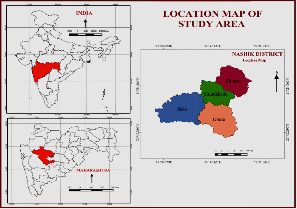 Figure 1
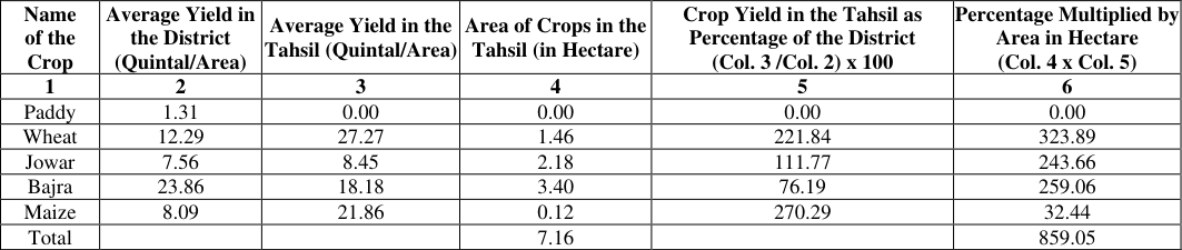 Table 1
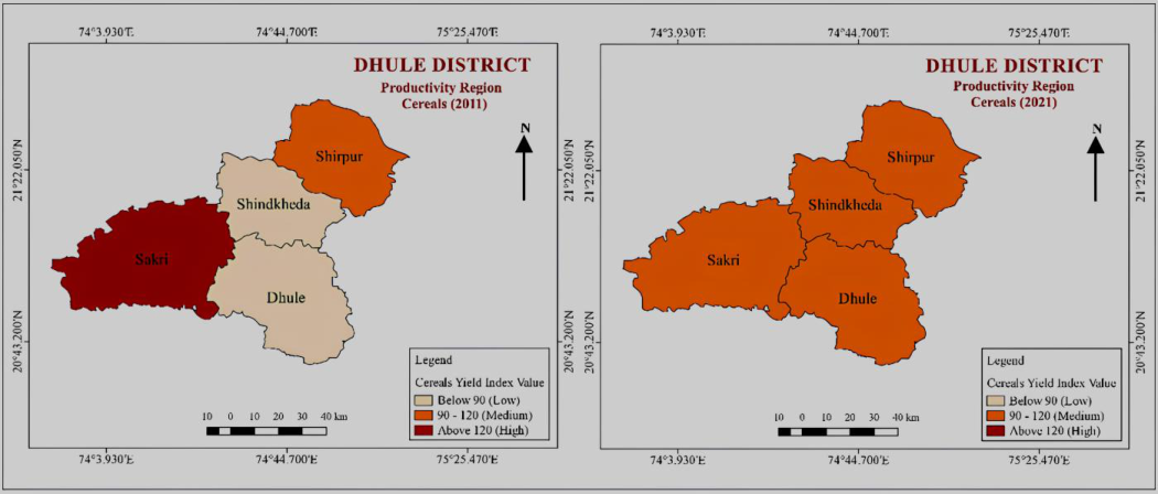 Figure 2
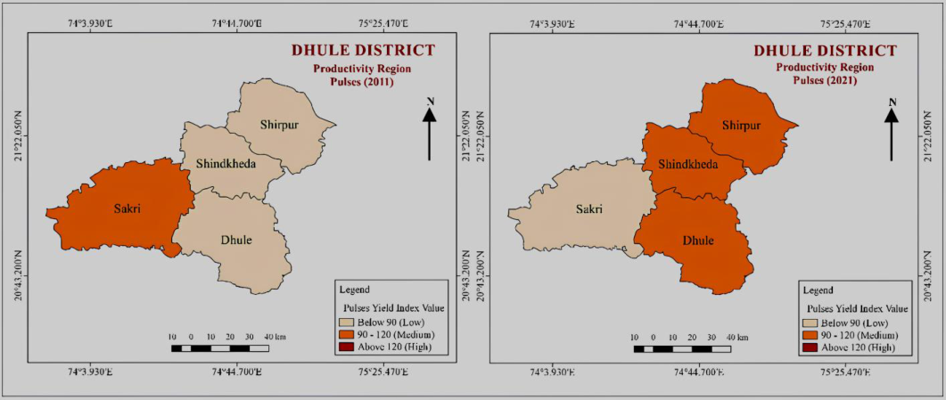 Figure 3
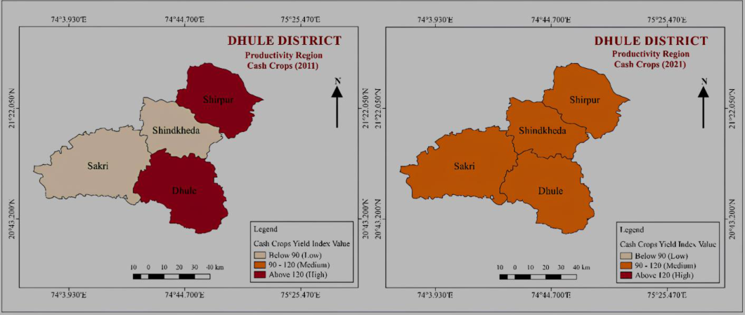 Figure 4
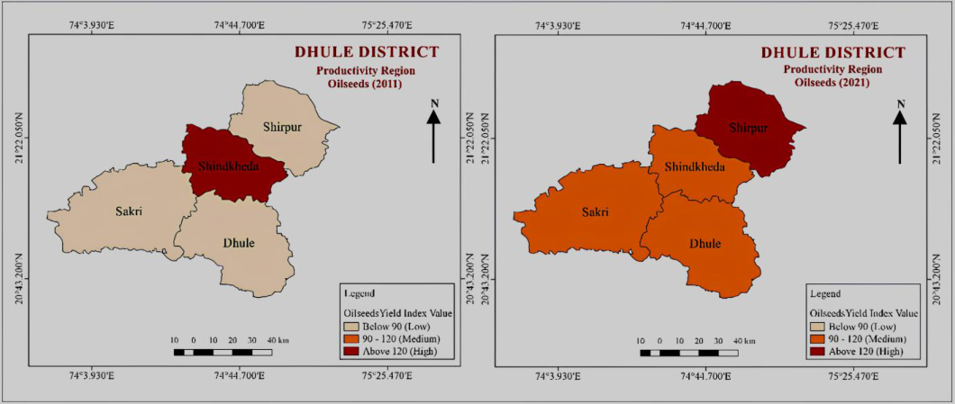 Figure 5
 Table 2
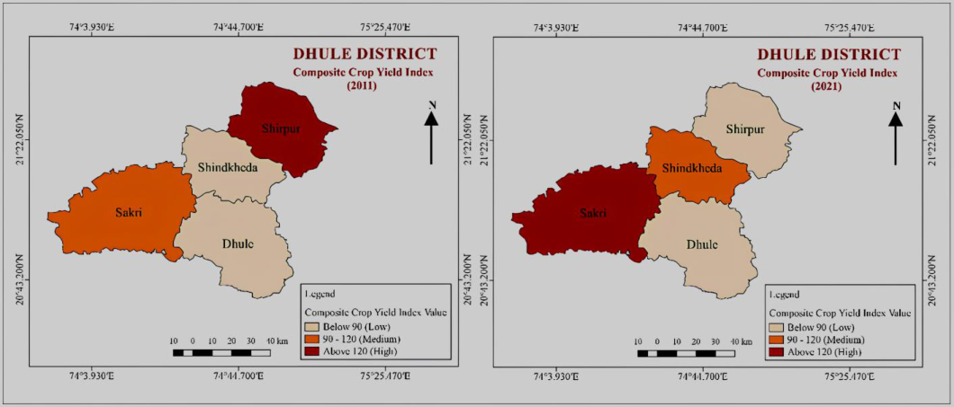 Figure 6
Introduction
Agriculture has provided basic facilities to people since ancient times till today and there will be no change in the future. The goods produced in the agricultural sector are called agricultural productivity. Agricultural productivity is defined as the ratio of total agricultural output to total inputs used in agricultural production. Productivity refers to the total quantity of output, while productivity refers to output relative to resources expended. Productivity is used interchangeably to explain production. Therefore, agricultural productivity can be defined as a measure of the efficiency in agriculture in which land, labour, capital and other resources are used. Dhule district of Maharashtra is a district with an agrarian economy. About 70 percent of the population is directly or indirectly engaged in agriculture. In Maharashtra and Dhule too, agriculture has shifted from subsistence to commercial agriculture in the last three decades. The district has wide variation in physical-climatic and socio-economic aspects. The eastern part of the district is known as rain shadow region. Inadequate rainfall affects cropping patterns and agricultural productivity. Green revolution technology has played an important role in the development of agriculture but it has also created regional imbalances in crop productivity. Therefore, there is considerable scope for improving agricultural production and productivity per hectare and per agricultural worker, especially in small and marginal farms, which will help increase income levels and improve the standard of living of rural people. Agriculture of a region is the outcome of a complex interaction of several factors like available human resources, nature of the land, soil fertility, availability of rainfall, temperature suitability, application of tools and techniques as well as the demand of agricultural output. As the availability of all these factors are not uniformly distributed, the cropping pattern and yield vary from region to region. Agricultural geographers and economists have long been engaged in a study of correlation between the said factors and level of productivity in various parts of the world (Yang, 1968; Thompson, 1926; Kendal, M.G., 1939; Stamp, 1952; Shafi M., 1960; Sapre, S.G. & Deshpande, V.D., 1964 and Bhatia, S.S., 1967) [21,19,6,15,10,8,2] .
Several methods have evolved during the course of time to measure as well as to interpret the agricultural productivity in developed and developing countries. To compute the agricultural productivity Yang's 'Crop Yield Index' method has been applied by Siddiqi (1999) [13] and Rahman (1976) [18] for computing the agricultural productivity in different parts of India. In the present paper agricultural productivity computed by Yang's 'Crop Yield Index' method has been used, since it considers the yield of all crops compared with the average yield of crops in the district Sahu et al., (2022) [4] . The present study attempts to examine disparities in agricultural productivity and relative changes that have occurred in agricultural production in two different periods in the year 2011 and 2021 in the Dhule District. By using Yang's 'Crop Productivity Index' find out the crop productivity variations of 14 major crops (Grouped under cereal, pulses, cash crops and oilseeds) during 2011 and 2021. Agricultural productivity is controlled by physical, institutional and technological factors operating in the region. Measurement and comparative analysis of agricultural productivity enables us to outline the areas that are performing efficiently or less efficiently as compared to other farming areas.
Study Area
The Dhule district covers an area of 7195 km² and is located between 20°37' and 21°37' N and 73°51' and 75°12' E. The division of the Dhule district on July 1, 1998 created it into the Existence of Nandurbar district. It is bordered by Jalgaon district to the east, Nandurbar district to the west, Barwani districts of Madhya Pradesh to the north and Nashik district to the south. The climate in Dhule district is classified as tropical. Throughout the year, Dhule district receives 110.6 days of rain and receives up to 607 mm of rainfall. With an average maximum temperature of 29.1 °C and an average minimum temperature of 17.8 °C, January is the coldest month in Dhule, while the warmest month in Dhule district is May, with an average maximum temperature of 40.9 °C and an average minimum temperature of 28.7 °C. Dhule district lies at the foot of Satpuda hill. The Sahyadri mountain range has touched the western side of this district. There are also the mountains of Galna. Tapi, Panzara, Kan, Arunavati, Amravati and Aner rivers flow through the district.
Methodology
The present study is based on primary and the secondary data obtained from the Socio-Economic abstract of Dhule district (2011 and 2021). Various thematic maps related to crop yield index were prepared with the help of GIS. The productivity indices of crops considered for each tahsil were computed according to the methodology initiated by Yang (1966) [20] i.e., the computation of the Crop Yield Index. For the computation of an index (Tehsil Shirpur can be considered as an example). Initially, it is needed to take the yields of all the crops considered in the tahsil and compare them with the average yields of the same crops grown in the district. Before computing the crop, yields index for Shirpur, the average yield of each crop cultivated in the entire district should be considered. Then, by dividing the yield per hectare of a crop in the tahsil by the average yield of the same crop in the district, a percentage figure is obtained, which when multiplied by 100, gives an index number, as shown in column 5 of Table 1. By incorporating the area devoted to each crop as a weight to multiply this with the percentage index, the products are obtained as listed in column 6 of the table. By adding the products (of column 6) and dividing the sum of products by the total of crop area in the tahsil (the sum of column 4), the average index thus obtained is the desired crop index for the tahsil, using area devoted for the cultivation of crop as a weight.
Crop Productivity Regions (2011 and 2021)
There are several crops grown in Dhule district among them 14 major crops selected for a study of regional variation in agricultural productivity. All of these crops together accounted for 96.60 percent of the total cropped area in 2021. For analysis these crops were grouped into four broad categories: (a) cereal crops to include paddy, wheat, Jowar, bajra, and maize. (b) Pulses to include gram (Harbhara), pigeon pea (Tur), and green gram (Moong) abd black gram (Udid). (c) Cash crops to include sugarcane and cotton (Bhopala UD et al, 2023) [20] . (d) Oilseeds to include soya bean, groundnut and other oilseeds. With the computation of crop productivity for all the Tehsil of Dhule district, the productivity indices were categorized into high, medium and low. A. Productivity Regions -Based on Cereal Crops Yield Index Cereals are the important crops grown in the Dhule district to cover an area of about 61.7 thousand hectares (13.07 percent) of the total selected cropped area (472078 hectare) during the year 2011. Jowar is a dominated crop among cereals and it is grown in all tahsils of the district. Jowar, bajra, wheat and paddy are major cereal crops which are covered around 55629-hectare area in Dhule district. In 2011, Sakritahsil have high productivity of cereals. The high productivity indices are due to the assured irrigation facilities, suitable physio-climatic conditions, using high yielding varieties of seeds and agricultural implements and machinery. The Shirpurtahsil characterized with medium productivity of cereals. The factors responsible for the medium productivity may be traced from the socioeconomic conditions of farmers which are not conducive for fast development. The areas marked with low productivity of cereals are found in the tahsils of Shindkheda and Dhule (Fig. 2). Most of the tahsils marked with low productivity due to poor quality of the soil, irregularity in rainfall, lack of irrigation facilities, and traditional method of farming and insufficient use of fertilizers. Total area under cereals crops cultivation increased from 61.7 thousand hectares from 2011 to 181.7 thousand hectares during 2021. During the year of 2021 all tahsils of forming medium productivity of cereals (Fig. 2).
B. Productivity regions -based on pulse crops (2011 and 2021)
Pulses are other important crops grown in the Dhule district. They occupied 26.1 thousand hectares (5.54 percent) of the total cropped area during the year 2011. There are no tahsils in high productivity category of pulses. Medium productivity has observed in Sakritahsil. Suitable physio-climatic conditions and availability of irrigation facilities causes to medium productivity of pulses in Sakritahsil. The remaining three tahsils of Shirpur, Shindkheda and Dhuleare characterized by low productivity (Fig. 3). In 2021, total area under pulses cultivation also increased from 26.1 thousand hectares from 2011 to 56.5 thousand hectares during 2021, and overall productivity of pulses were observed in increasing trend. During this period the tahsil of Sakrilose their previous position and shifted in low productivity category from medium productivity category of pulses. While the Shirpur, Shindkheda and Dhule tahsil shifted from low to medium productivity region of pulses (Fig. 3).
C. Productivity Regions -Based on Cash Crops (2011 and 2021)
Cultivation of cash constitutes the third ranking crops, and plays an important role in the agricultural economy. Sugarcane and cotton are major cash crops which are grown almost all tahsils of Dhule district. Cash crops covered 113.9 thousand hectares of land and accounted for 24.13 percent of the total cropped area during the year 2011. Out of four tahsils, two tahsils attained high productivity; they were namely, Shirpurand Dhuletahsils. These tahsils are situated northern and southern part of district which are relatively plain and low land area with availability of fertile soil in river valleys of river Tapiand Panzara. Most of these areas have available irrigation facilities through year. Most of the farmers also used fertilizers, HYV seeds and new techniques in cash crop farming. Therefore, productivity of cash crops observed higher in this area. The remaining two tahsils formed low productivity which was namely, Shindkheda and Sakri (Fig. 4). Topography, soil and climatic factors are not more favourable for cash crop productivity in these areas. Western part of the district consists poor soil due to hilly area and heavy rainfall which are not suitable for sugarcane crop. In 2021, total area under cash crop cultivation tremendously increased from 113.9 thousand hectares from 2011 to 241.5 thousand hectares during 2021, and overall productivity of cash crops were observed in increasing trend. During this period, Shirpur and Dhule tahsils lose their previous position and shifted in medium productivity category from high productivity category of cash crops. While the Shindkheda and Sakritahsils shifted from low to medium productivity region of cash crops (Fig. 4).
D. Productivity Regions-Based on Oilseeds Crops (2011 and 2021)
Cultivation of oilseeds constitutes an important position in the agricultural economy of the Dhule district. They covered an area of 270.2 thousand hectares (57.25 percent) of the total cultivated area in 2011. Soya bean and Groundnut is major crops among oilseeds, which are grown almost in all tahsils of the district. In 2011, high productivity of oilseeds can be seen in the tahsil of Shindkheda. In these tahsil physio-climatic conditions are more favourable for oilseeds. Most of the farmers cultivated oilseeds in Kharif season and groundnut also cultivated in summer season in that area where irrigation facilities are available. Farmers use a high-yielding variety of oilseeds and better marketing facilities make this region more conducive for the production of oilseeds. The tahsils of Shirpur, Sakri and Dhulefall under the low category of productivity (Fig. 5). In 2021, total area under cash crop cultivation seems to decline from 270.2 thousand hectares from 2011 to 27.7 thousand hectares during 2021, but overall productivity of oilseeds was observed in increasing trend. During this period, Shindkheda tahsil lose their previous position and shifted in medium productivity category from high productivity category of oilseeds. While the Shirpur, Dhule and Sakri tahsils shifted from low to medium productivity region of oilseeds (Fig. 5). In 2021, the Sakritahsil formed high productivity region. Shirpurtahsil shifted from high to low productivity region. Decreased productivity of cereals in Shirpur tahsil also affect composite score productivity of tahsil which are showing decreasing trend. In the low productivity category, Dhule tahsil maintain their position in this category during the year 2021. Two tahsils showing increasing during the year 2021, Shind Kheda tahsil shifted from low to medium productivity region and Sakritahsil shifted from medium to high productivity region (Fig. 6).
Conclusion
The study reveals that in Dhule district the variation in agricultural productivity at the tahsil level has been observed. The analysis during the period of 2011 and 2021 shows low agricultural productivity. The variation in productivity is influenced by the physio-climatic, socioeconomic and technological factors. The important parameter like soil always plays a vital role in enhancing crop growth and yield per hectare. The district has varieties in soil fertility and this influence on agricultural productivity. Northern and southern part of district deserved high productivity than central and western region. The socio-economic factors like size of landholding are also responsible for the decision making of the farmer. There is a preponderance of small and semi-medium holdings, and the fields are highly fragmented (Also some efforts have been made to consolidate the fields) ant traditional method of farming which show low yields in farming areas. Therefore, it is needed that the productivity of crops per hectare be increased at least in medium and low productivity areas. The application of new agricultural technology brought with high-yielding varieties, maintaining the soil productivity with using organic fertilisers and financial support to marginal farmers will be of great help to increases in productivity. The task of increasing agricultural productivity can also achieved by dividing the Dhule district into a number of micro agro-climatic zones and intensive efforts should be made to evolve new high-yielding varieties which may suit to each agro-climatic zone, taking into consideration the factors of socio-economic and cultural background of the region.
Figures and tables from the paper
| Index Range | Category | No. of Tehsils | Name of Tehsils |
|---|---|---|---|
| Year 2011 | |||
| Above 120 | High | 1 | Shirpur |
| 90-120 | Medium | 1 | Sakri |
| Below 90 | Low | 2 | Shindkheda, Dhule |
| Year 2021 | |||
| Above 120 | High | 1 | Sakri |
| 90-120 | Medium | 1 | Shindkheda |
| Below 90 | Low | 2 | Shirpur, Dhule |
Table text extracted from the original PDF; superscript letters are shown inline. The original table image is below.
View original table image
References
19 in the original paper- Aktar N. Agricultural Productivity and Productivity Regions in West Bengal. The NEHU Journal. 2015;13(2):49-61.
- Bhatia SS. A new Approach to Measure Agricultural Productivity in Uttar Pradesh. Economic Geography. 1967;43(3):244-260.
- Census of India. District Census Handbook of Nashik 2011; c2001-2011.
- Sahu S, Choudhary AS, Raj S, Ghode N, Kumar A. Effect of micronutrients on yield attributes of tomato. Int. J Agric. Nutr., 2022;4(1):34-38. DOI: 10.33545/26646064.2022.v4.i1a.51
- Chaudhari JK. Disparities in the Agricultural Productivity in Deoghar District of Jharkhand: A geographical Analysis. Remarking. 2016;(10):66-73.
- Kendall MG. The Geographical Distribution of Crop productivity in England. Journal of the Royal Statistical Society, 1939, 162(Part II).
- Munir A. Agricultural Productivity and Regional Development: A Case Study of the Sub-Himalayan East Region of Uttar Pradesh. The Geographer. 1988;35(2):48-49.
- Sapre SG, Deshpande VD. Inter district variation in agricultural efficiency in Maharashtra State. Indian Journal of Agricultural Economies. 1964;19(1):242252.
- Shafi M. Food Production Efficiency and Nutrition in India. The Geographer. 1967;14:23-27.
- Shafi M. Measurement of Agricultural Efficiency in Uttar Pradesh. Economic Geography. 1960;36(04):296305.
- Siddiqui SH. Pattern of Agricultural Productivity in Bihar. The Geographer. 1999;46(1):107-117.
- Siddique SH, Usmani TM. Patterns of Agricultural Productivity in Bihar. The Geographer. 2003;50(1):73.
- Siddiqi SH, Rehman H, Siddiqui MF. Regional Analysis of Agricultural Productivity in Bihar. The Geographer. 1999;31(1):77-85.
- Singh J. Agricultural Geography, 1985, 242.
- Stamp LD. The Measurement of Land Resources. The Geographical Review. 1958;48(1):110-16.
- Socio-Economic Reviews & Statistical Abstracts of Nashik District; c2010-2016.
- Rehman H. Mechanization of Farming and its Impact on Food Crop Productivity in Uttar Pradesh. The Geographer. 1976;23(2):43-56.
- Thompson RJ. The Productivity of British and Danish Farming. Journal of the Royal Statistical Society. 1926;89(Part II):218.
- Bhopala UD, Dhandhalya MG, Rathod RB. Spatiotemporal dynamics in cotton area, production and productivity: A worldwide scenario. Int J Stat Appl Math 2023;8(6):183-186. DOI: 10.22271/maths.2023.v8.i6b.1540