
Research article · 2024 · Full text
International Journal of Geography Geology and EnvironmentUrban expansion and loss of agricultural land: A GIS based study of Jalgaon city (M.S.) India
Volume 6(1) · Pages 37–45 · DOI: 10.22271/27067483.2024.v6.i1a.200 ↗
Research areasAgricultural Economics and Practices
Abstract
Author-writtenIn This paper uses remote sensing (aerial photographs and satellite images) combined with field checks and surveys to measure the loss of agricultural land to urban expansion in Jalgaon City between 2006 and 2012. It this paper some techniques use a detailed mapping of land use changes and includes details of the location of the agricultural land losses, The agricultural land has continued to shrink due to rapid urbanization. The paper also describes nonagricultural land uses were responsible for agricultural land losses. Where urbanization is reducing the supply of high-quality agricultural land.
Summary
Source-checkedPlain-language reading of the full paper, prepared with AI and checked against the text. Each point links to the authors' own words.
Why it matters
- Urban expansion involves the physical growth of cities, which results in increased population density and a larger built-up area. View evidence ↗
- Rapid urbanization is causing a reduction in the supply of high-quality agricultural land as it is replaced by non-agricultural land uses. View evidence ↗
The question
- The study aims to measure the loss of agricultural land resulting from urban expansion in Jalgaon City between 2006 and 2012. View evidence ↗
What they did
- The researchers used a combination of remote sensing, including satellite images and aerial photographs, along with field surveys. View evidence ↗
- Advanced GIS and remote sensing techniques were used to create thematic maps, while cadastral maps and toposheets helped define city and ward boundaries. View evidence ↗
- The study relied on secondary and tertiary data obtained from both government and non-government organizations in Jalgaon. View evidence ↗
What they found
- Between 1901 and 2011, the highest population growth rate in Jalgaon occurred in 1991, reaching 66.6%. View evidence ↗
- The municipal jurisdiction of Jalgaon expanded more than fourfold, growing from 11.45 sq. km to 68.24 sq. km. View evidence ↗
What it means
- The high population growth rate is attributed to the city's economic transition from an agricultural base to an industrial one. View evidence ↗
- The authors state that urban expansion has caused significant damage to agricultural land. View evidence ↗
Visual summary
3 visualsIllustrations explain the paper; charts are replotted from the paper's own table values.
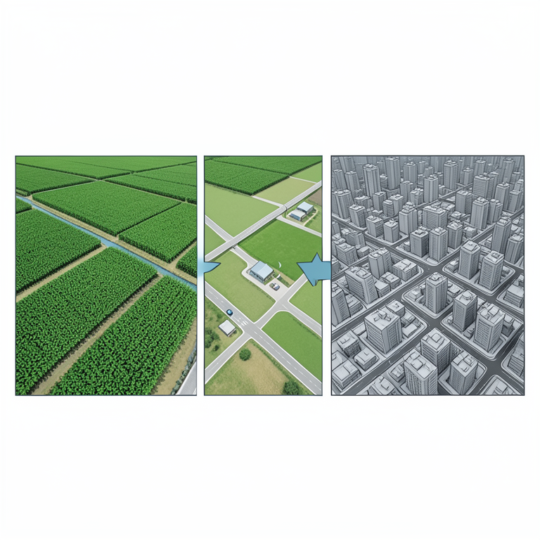
Urbanization vs Agriculture
AI-generated conceptual illustration (Agricultural land and urban cityscapes in Jalgaon, India). It explains the idea and does not show study data.
View source evidence ↗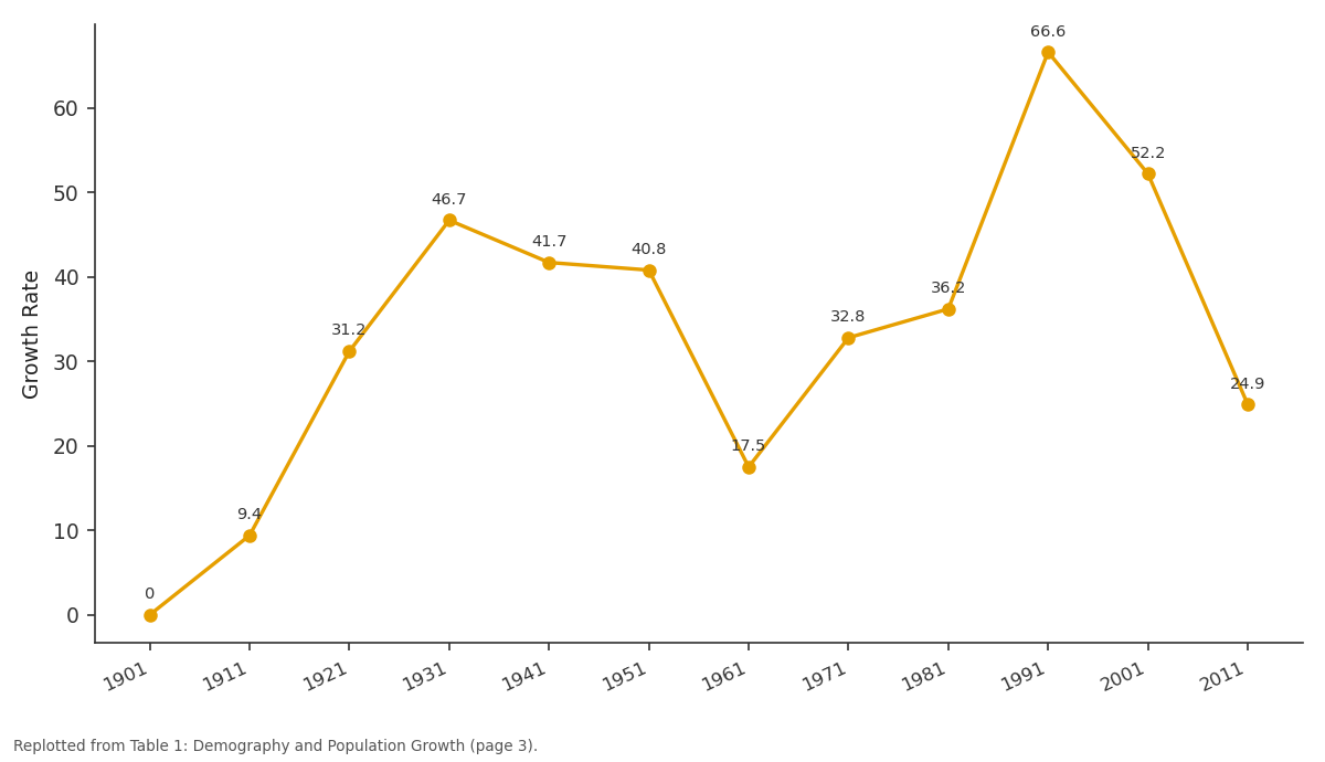
Growth Rate: 1901 vs 1911 vs 1921 vs 1931 vs 1941
Replotted from Table 1 (page 3) of the original paper. Every bar is the paper's own table value.
View source evidence ↗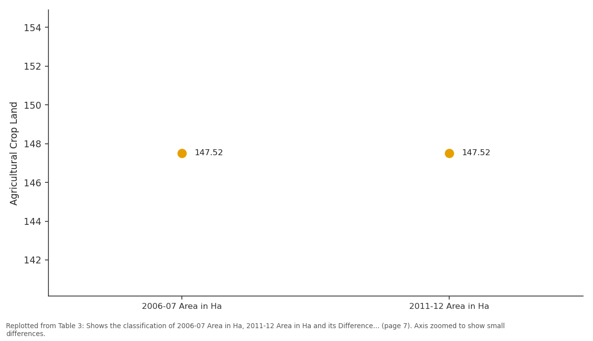
Agricultural Crop Land: 2006-07 Area in Ha vs 2011-12 Area in Ha
Replotted from Table 3 (page 7) of the original paper. Every bar is the paper's own table value.
View source evidence ↗Figures & tables
From the original paper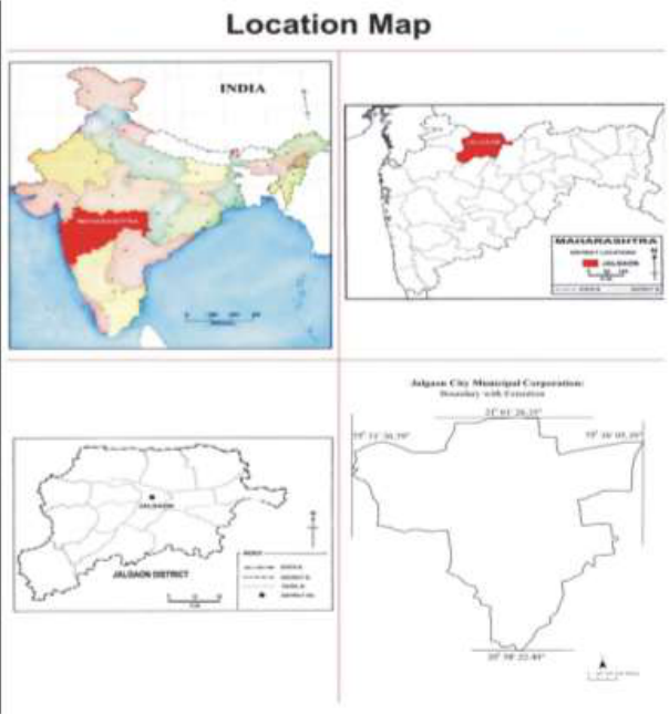 Figure 1
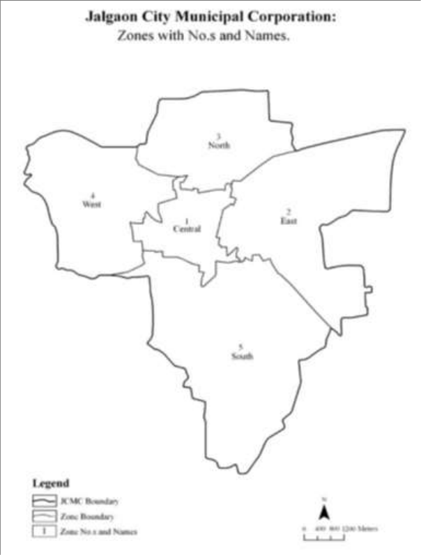 Figure 2
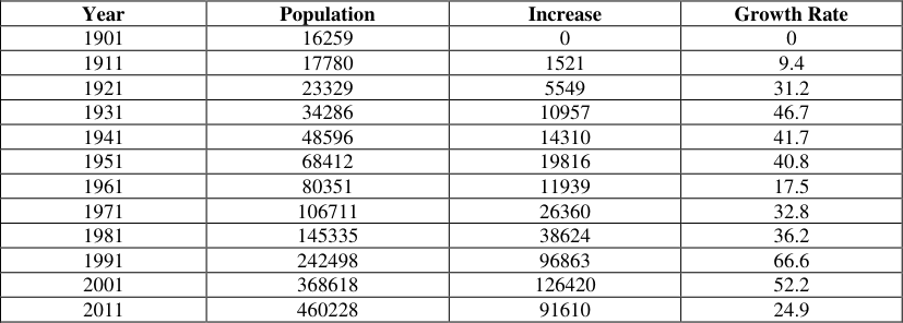 Table 1
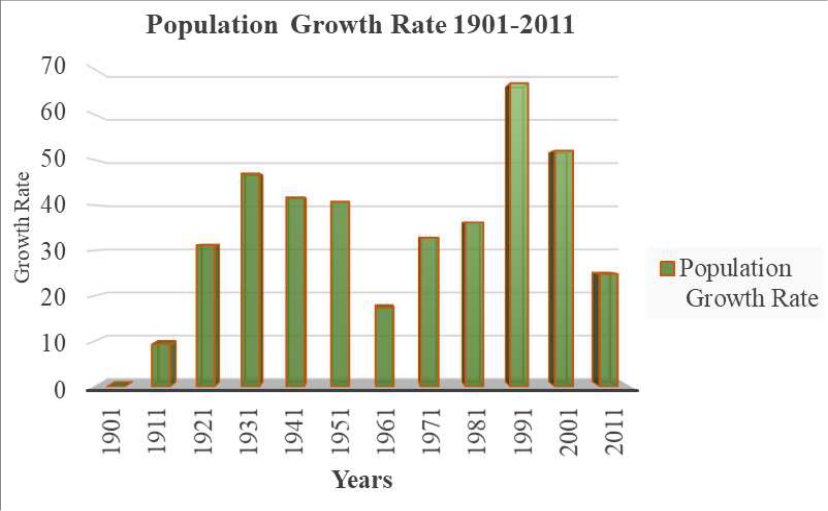 Figure 3
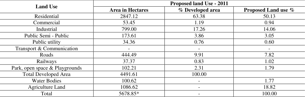 Table 2
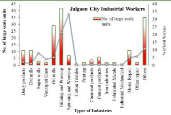 Figure 4
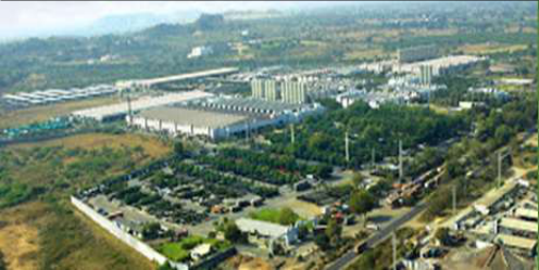 Figure 5
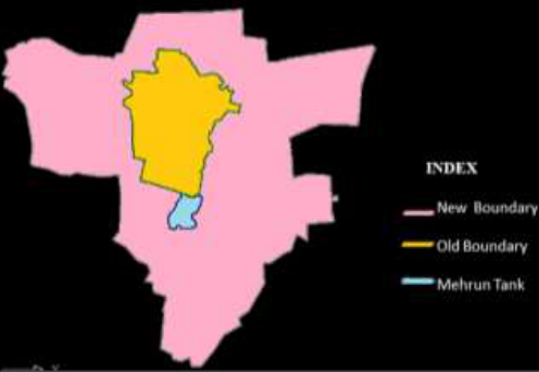 Figure 6
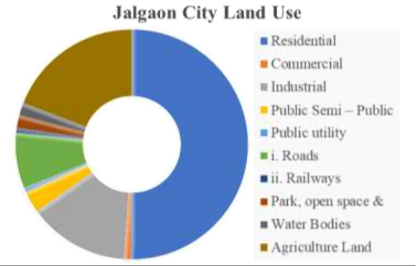 Figure 7
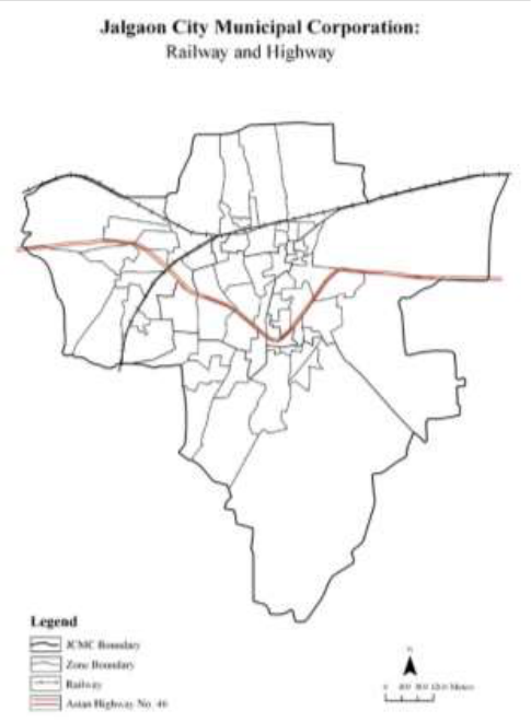 Figure 8
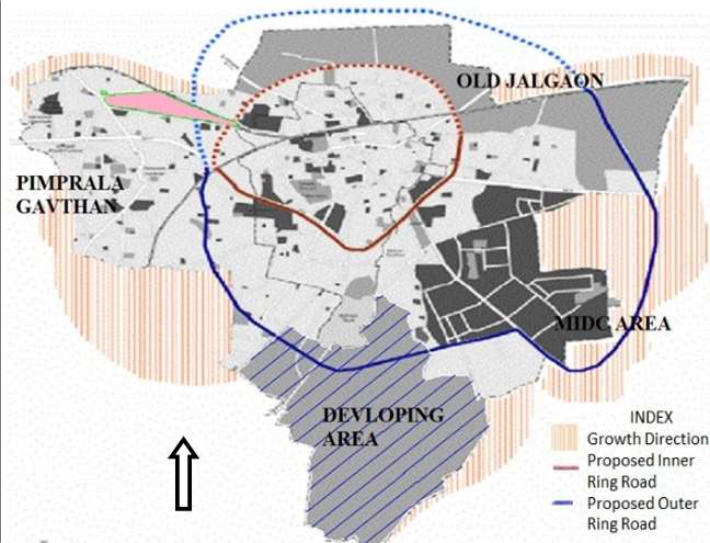 Figure 9
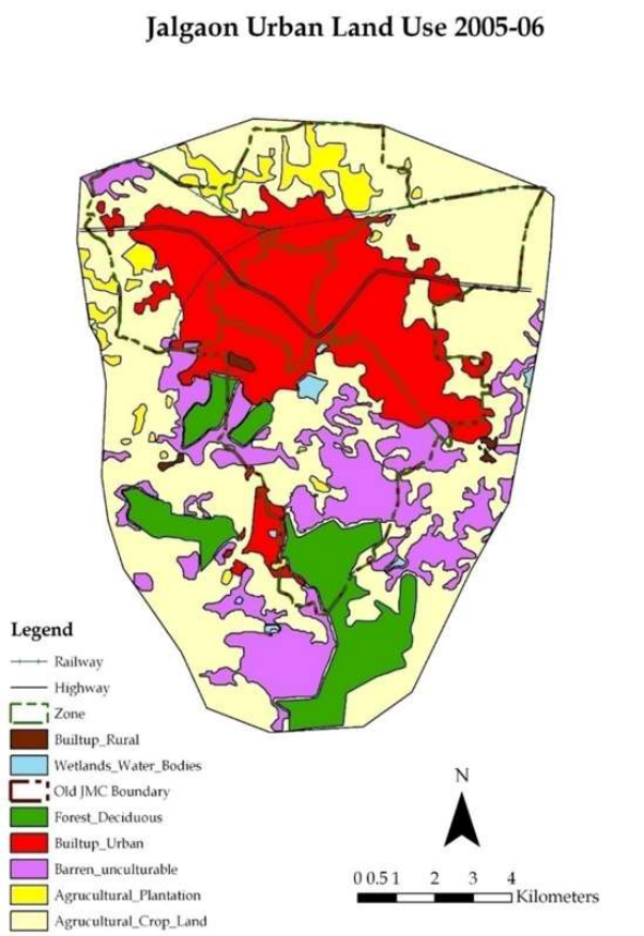 Figure 10
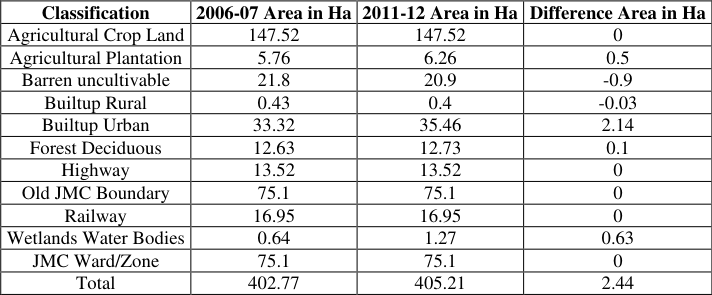 Table 3
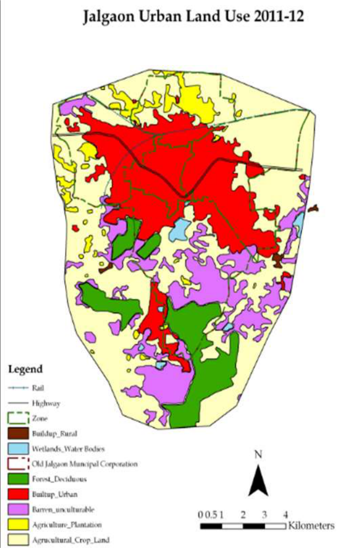 Figure 11
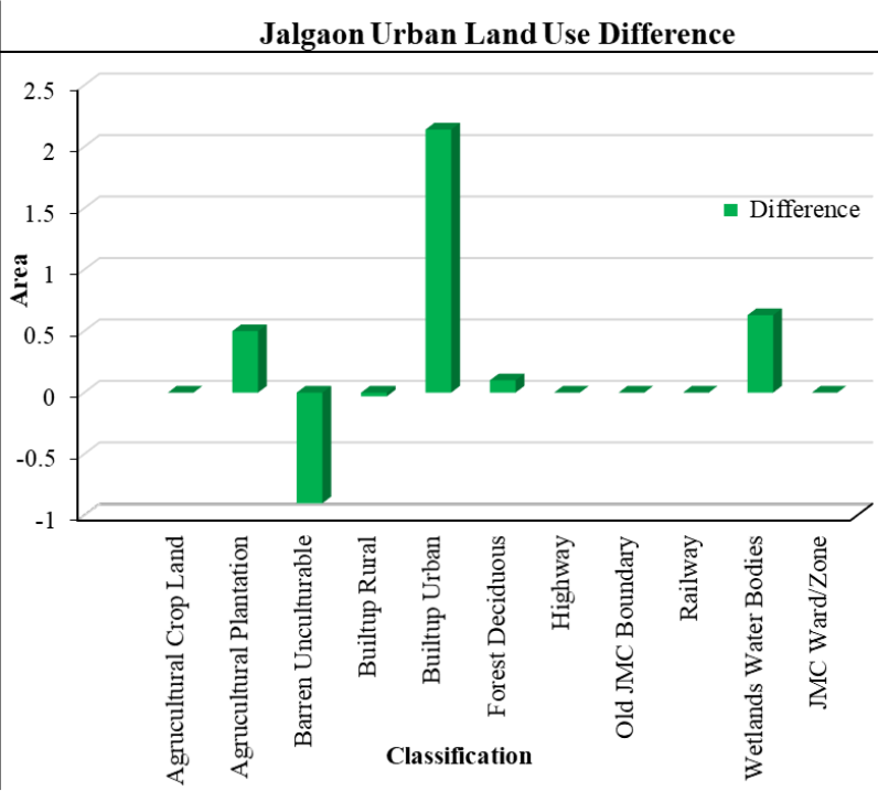 Figure 12
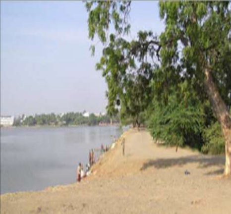 Figure 13
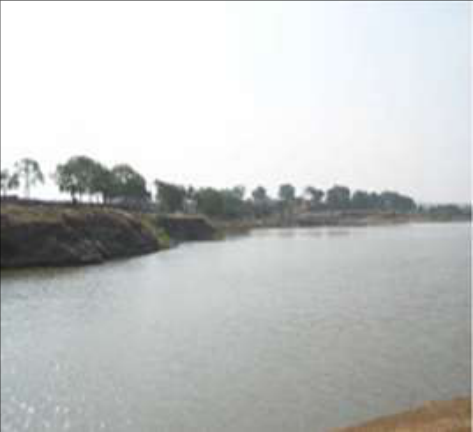 Figure 13
Introduction
Urban expansion is the physical growth of urban areas, which leads to further development of towns or cities, population growth, increase of buildup area, high density of population and it’s also psychological stage of the urban way of life. The early insight of some prescient scholars are how common understanding especially those of George Perkins Marsh in the mi nineteenth century who documented the pervasive nature of land modification by human activity. Land use/cover is two separate terminologies which are often used inter changeably (Dimyati et al., 1996) [12]. Land cover refers to the physical characteristics of earth’s surface, captured in the distribution of vegetation, water, soil and other physical features of the land, including those created solely by human activities e.g., settlements.
Research Hypothesis Urban development impact has been noticed of land-use & land cover in Jalgaon city. Aims & Objective 1. To study urban development status in Jalgaon city. 2. To investigate land-Use & Land Cover pattern in study area. 3.
To find out measure changes in land-use pattern. 4. To analyze urbanization problems & solution in this study region Research Methodology This project work has used secondary & tertiary data sources from Govt. & Non-govt. organization from Jalgaon city. We have applied various cartographic techniques for data analysis. Researcher has used computer cartographic tools for mathematical calculation and graph.
Advance GIS & RS techniques are applied by researcher for preparation of various thematic maps of related study. Also, Cadastral maps & toposheets has been used for demarcation of ward & city boundaries our study region. Location and Extent Jalgaon is a city in western India, north of Maharashtra in jalgaon district and in the agriculture region of Khandesh. Jalgaon geographical coordinates are 21◦1’0” North, 75◦34’0” East.
IJGGE 2024; 6(1): 37-45 Prajakta R Baviskar PG and Research, Department of Geography, Mahatma Gandhi Shikshan Mandalache Dadasaheb Dr. Suresh G. Patil College, Chopda, Jalgaon, Maharashtra, India Dr. Siddharth B Sonawane Research Guide, Department of Geography, Smt.
NNC Arts, Comm. & Science College, Kusumba, Dhule, Maharashtra, India Dr. Shaileshkumar A Wagh Head, PG and Research, Department of Geography, Mahatma Gandhi Shikshan Mandalache Dadasaheb Dr. Suresh G. Patil College, Chopda, Jalgaon, Maharashtra, India Prajakta R Baviskar PG and Research, Department of Geography, Mahatma Gandhi Shikshan Mandalache Dadasaheb Dr.
Suresh G. Patil College, Chopda, Jalgaon, Maharashtra, India https://www.geojournal.net/ Fig 1: Jalgaon City Location Map Fig 2: Jalgaon City Municipal Corporation Zone Wise Map https://www.geojournal.net/ Table 1: Demography and Population Growth Year Population Increase Growth Rate 1901 16259 0 0 1911 17780 1521 9.4 1921 23329 5549 31.2 1931 34286 10957 46.7 1941 48596 14310 41.7 1951 68412 19816 40.8 1961 80351 11939 17.5 1971 106711 26360 32.8 1981 145335 38624 36.2 1991 242498 96863 66.6 2001 368618 126420 52.2 2011 460228 91610 24.9 Source: Census of India 2011 The growth rate of jalgaon city has been on the rise from 1951 to 2001. The city has registered a decadal growth rate of about 51.91% and an average annual growth rate of 5.19% during 1991-2001. Source: census of India 2011 Fig 3: Population Growth Rate 1901 to 2011 It is observed that out of total population of Jalgaon city of 460228 recorded in 2011 census, the mail population is 240590 and female population is 219638 respectively.
| Year | Population | Increase | Growth Rate |
|---|---|---|---|
| 1901 | 16259 | 0 | 0 |
| 1911 | 17780 | 1521 | 9.4 |
| 1921 | 23329 | 5549 | 31.2 |
| 1931 | 34286 | 10957 | 46.7 |
| 1941 | 48596 | 14310 | 41.7 |
| 1951 | 68412 | 19816 | 40.8 |
| 1961 | 80351 | 11939 | 17.5 |
| 1971 | 106711 | 26360 | 32.8 |
| 1981 | 145335 | 38624 | 36.2 |
| 1991 | 242498 | 96863 | 66.6 |
| 2001 | 368618 | 126420 | 52.2 |
| 2011 | 460228 | 91610 | 24.9 |
Table text extracted from the original PDF; superscript letters are shown inline. The original table image is below.
View original table image
In 1901 population of Jalgaon1 6259. The growth rate of Jalgaon city has been on the rise from 1971 to 1991. The city has registered a decadal growth rate of about 51.91% and an average annual growth rate of 5.19% during 1991- 20011. As per my observation from 1901 to 2011 there was highest population growth rate (66.6) in the year 1991as compared to other year. 3 Municipal Area and population Density.
The Jalgaon Municipal limit covers an area of 68.24 sq. km, out of which 11.45 sq. km is the old municipal limit and 56.79 sq. km extended additional area. This indicates that the municipal territorial jurisdiction has increased more than four times i.e. from 11.45 sq. km to 68.24 sq. km. The overall population density of jalgaon city, according to 2001 census is 53.94 inhabitant/hectors. Growth Trends and Loss of Agriculture Area Trade and commerce: The Jalgaon region are well known for the production of jawar, dal bajra, cotton, groundnuts etc.
About 33.49% of total workers were engaged in spinning and weaving and about 21.38% of workers were engaged in ginning and weaving. It shows that, more than 54% of total industrial workers are engaged in textile-oriented industries and rest of it is agriculture oriented industrial workers. https://www.geojournal.net/ Fig 4: Jalgaon City Industrial Workers 56.78 sq. km., which was included in the corporation limit. Jalgaon is also emerging destination for small and medium scaled manufacturing, engineering and IT solutions, because of its proximity from four metros in the state i.e. Mumbai, Pune, Nashik and Aurangabad.
There are major companies in the city like Raymond, Bosch, Jain Irrigation and Legrand etc. Fig 5: Jalgaon Industries Municipality limit As the district headquarters jalgaon is the largest urban agglomeration of the jalgaon district. Jalgaon city ranks 16th amongst other cities in Maharashtra with a total population of 3.68 lakes and decadal growth rate of 51.9%. The municipal area consists of the old municipal limit, which covers an area of 11.45 sq.km on additional area of Fig 6: Expansion of Jalgaon City - Map Occupational Structure The workforce force participation rate in primary, secondary & tertiary sector is 4.7%, 3.2% & 92.10% respectively. 1.
General Land Use Pattern. 2. Land use Analysis. Land use assessment helps us to understand the development patterns of the city and its future growth directions. Table 2: Land use 2011 Land Use Proposed land Use - 2011 Area in Hectares % Developed area Proposed Land use % Residential 2847.12 63.38 50.13 Commercial 53.45 1.19 0.94 Industrial 799.00 17.26 14.06 Public Semi - Public 173.61 3.86 3.05 Public utility 34.36 0.76 0.60 Transport & Communication - - - Roads 444.49 9.91 7.82 Railways 37.37 0.83 1.02 Park, open space & Playgrounds 102.21 2.31 1.79 Total Developed Area 4491.61 100.00 Water Bodies 100.62 - 1.77 Agriculture Land 1086.62 - 18.82 Total 5678.85* - 100.00 Source: City survey office Jalgaon https://www.geojournal.net/ Fig 7: Proposed Agriculture land break-up hectare. 4.
| Land Use | Proposed land Use - 2011 | — | — |
|---|---|---|---|
| Area in Hectares | % Developed area | Proposed Land use % | |
| Residential | 2847.12 | 63.38 | 50.13 |
| Commercial | 53.45 | 1.19 | 0.94 |
| Industrial | 799.00 | 17.26 | 14.06 |
| Public Semi - Public | 173.61 | 3.86 | 3.05 |
| Public utility | 34.36 | 0.76 | 0.60 |
| Transport & Communication | - | - | - |
| Roads | 444.49 | 9.91 | 7.82 |
| Railways | 37.37 | 0.83 | 1.02 |
| Park, open space & Playgrounds | 102.21 | 2.31 | 1.79 |
| Total Developed Area | 4491.61 | 100.00 | |
| Water Bodies | 100.62 | - | 1.77 |
| Agriculture Land | 1086.62 | - | 18.82 |
| Total | 5678.85* | - | 100.00 |
Table text extracted from the original PDF; superscript letters are shown inline. The original table image is below.
View original table image
Public and Semi-public: An area of 173.61 While 50 percent of the additional area is proposed for residential purposes, a significant 14.06% of the area is proposed for industrial uses. Each of the land use categories is further detailed below. 1. Residential: An area of 2847.12 hectares/28.47 sq.km, hectares/1.74 sq. km, about 3.05% has been proposed for public purposes considering the land requirements of various Government/Semi Government agencies. 5. Public Utility: An area of 34.36 hectares/0.34 sq. km, about 0.60% has been proposed for public utilities. 6.
Transport and Communication: An area of 444.49 about 51.13% has been reserved for residential purposes, with an average density of 200 persons per hectare. 2. Commercial: An area of 53.45 hectares/0.53 sq.km, about 0.94% has been proposed for commercial purposes in the Development Plan. 3. Industrial: Industrial activity mainly occurs in the hectares/4.45 sq. km, about 7.82% has been proposed for Roads and the Railways have covered 37.37/0.37 sq. km, about 1.02%. 7. Park, open spaces, Playground and Greenbelts: Areas of 102.21 hectares/1.02 sq. km, about 1.79% plus 1086.62 hectares/10.87 sq. km, about 18.82% have been proposed as Non-Development Zones.
MIDC area and Co-operative Industrial Estate on the eastern side of Jalgaon. An area of 799 hectares/7.99 sq. km, 14.06% has been proposed for industrial uses considering an overall density of 45 workers per Fig 8: Jalgaon growth directions https://www.geojournal.net/ Fig 9: Jalgaon growth directions and future proposals Fig 10: Jalgaon urban land use 2005-06 https://www.geojournal.net/ Fig 11: Jalgaon urban land use 2011-12 Table 3: Shows the classification of 2006-07 Area in Ha, 2011-12 Area in Ha and its Difference Area in Ha Classification 2006-07 Area in Ha 2011-12 Area in Ha Difference Area in Ha Agricultural Crop Land 147.52 147.52 0 Agricultural Plantation 5.76 6.26 0.5 Barren uncultivable 21.8 20.9 -0.9 Builtup Rural 0.43 0.4 -0.03 Builtup Urban 33.32 35.46 2.14 Forest Deciduous 12.63 12.73 0.1 Highway 13.52 13.52 0 Old JMC Boundary 75.1 75.1 0 Railway 16.95 16.95 0 Wetlands Water Bodies 0.64 1.27 0.63 JMC Ward/Zone 75.1 75.1 0 Total 402.77 405.21 2.44 https://www.geojournal.net/ Fig 12: Jalgaon urban land use difference Fig 13: Mehrun Tank
| Classification | 2006-07 Area in Ha | 2011-12 Area in Ha | Difference Area in Ha |
|---|---|---|---|
| Agricultural Crop Land | 147.52 | 147.52 | 0 |
| Agricultural Plantation | 5.76 | 6.26 | 0.5 |
| Barren uncultivable | 21.8 | 20.9 | -0.9 |
| Builtup Rural | 0.43 | 0.4 | -0.03 |
| Builtup Urban | 33.32 | 35.46 | 2.14 |
| Forest Deciduous | 12.63 | 12.73 | 0.1 |
| Highway | 13.52 | 13.52 | 0 |
| Old JMC Boundary | 75.1 | 75.1 | 0 |
| Railway | 16.95 | 16.95 | 0 |
| Wetlands Water Bodies | 0.64 | 1.27 | 0.63 |
| JMC Ward/Zone | 75.1 | 75.1 | 0 |
| Total | 402.77 | 405.21 | 2.44 |
Table text extracted from the original PDF; superscript letters are shown inline. The original table image is below.
View original table image
Conclusion
1. Jalgaon city has experienced rapid urban expansion in The various types of pollution are 1. Water pollution. 2. Air pollution. 3.
Noise pollution. 4. The population of the city is at a dynamic or self- the last decade and a half, with population growth and an increase in urbanized extent of the city. 2. Jalgaon faces other common challenges like accumulation of garbage, traffic congestion, deteriorating roads and pollution. Issues, Potential and Challenges in environment sector The most important environmental issue in Jalgaon is attributed to pollution. motivated stage, it is expected to grow further in the coming decades.
It reveals that very high growth rate in population occurred due to transition of city economy from agriculture to industrial. 5. In city loss of green cover and open spaces. https://www.geojournal.net/ 6. Urban expansion is really good for developing & on remote sensing and GIS data. Sensors. 2008;8(12):8201-23. 10.
Tian Y. Mapping suburbs based on spatial interactions and effect analysis on ecological landscape change: A case study of Jiangsu Province from 1998 to 2018, Eastern China. Land. 2020;9(5):159. 11. Tian Y.
Mapping suburbs based on spatial interactions and effect analysis on ecological landscape change: A case study of Jiangsu Province from 1998 to 2018, Eastern China. Land. 2020;9(5):159. 12. Dimyati MU, Mizuno K, Kobayashi S, Kitamura T. An analysis of land use/cover change in Indonesia.
International Journal of Remote Sensing. 1996;17(5):931-944. 13. Vermeulen SJ, Aggarwal PK, Ainslie A, Angelone C, Campbell BM, Challinor AJ. Agriculture, food security and climate change: Outlook for knowledge, tools and action. CCAFS Report; c2010. 14.
Goswami M, Nautiyal S. Transitional peri-urban landscape and use of natural resource for livelihoods. Socio-economic and Eco-biological Dimensions in Resource use and Conservation: Strategies for Sustainability; c2020. p. 435-57. 15. Somvanshi SS, Kumari M, Sharma R.
Spatio-temporal processing city, but not for agriculture land, they have some limit. Continuous addition of household waste and sewage into the nallas renders the Mehrun and Ambedkar lakes to be polluted. Suggestions Ease communication and transport networks by designing proper road systems. Mass plantation program by the industries and adjoining local pollution will help to control the ambient air pollution levels. Awareness on pollution, health impacts of pollution and need for sustainable development amongst the industrial management, workers and population will help to improve the quality of environment in the area. The reason for the high growth rate is due to the influx of population from the rural areas in search of employment/ work/business/ education etc. Due to the urban expansion lots of damage ascends agricultural land.
References
9 in the original paper- Long H, Tang G, Li X, Heilig GK. Socio-economic analysis of rural-urban transitions and transformations in Gautam Buddha Nagar, India. International Journal of Environmental Science and Technology. 2024;21(5):5079-88. driving forces of land-use change in Kunshan, the Yangtze River Delta economic area of China. Journal of Environmental management. 2007;83(3):351-64.
- Naikoo MW, Rihan M, Shahfahad, Peer AH, Talukdar S, Mallick J. Analysis of peri-urban land use/land cover change and its drivers using geospatial techniques and geographically weighted regression. Environmental Science and Pollution Research. 2023;30(55):116421- 116439.
- Yu M, Yang Y, Chen F, Zhu F, Qu J, Zhang S. Response of agricultural multi functionality to farmland loss under rapidly urbanizing processes in Yangtze River Delta, China. Science of the Total Environment. 2019;666:1-1.
- Girma Y, Terefe H, Pauleit S, Kindu M. Urban green spaces supply in rapidly urbanizing countries: The case of Sebeta Town, Ethiopia. Remote Sensing Applications: Society and Environment. 2019;13:138- 49.
- Grădinaru SR, Kienast F, Psomas A. Using multi- seasonal Landsat imagery for rapid identification of abandoned land in areas affected by urban sprawl. Ecological indicators. 2019;96(2):79-86.
- Wang J, Liu Y. Tourism-led land-use changes and their environmental effects in the southern coastal region of Hainan Island, China. Journal of Coastal Research. 2013;29(5):1118-25.
- Sinha A, Sengupta T. Impact of energy mix on nitrous oxide emissions: An environmental Kuznets curve approach for APEC countries. Environmental Science and Pollution Research. 2019;26(3):2613-22.
- Tripathi R, Moharana KC, Nayak AD, Dhal B, Shahid M, Mondal B. Ecosystem services in different agro- climatic zones in eastern India: impact of land use and land cover change. Environmental monitoring and assessment. 2019;191:1-6.
- Peng J, Wu J, Yin H, Li Z, Chang Q, Mu T. Rural land use change during 1986-2002 in Lijiang, China, based