
Research article · 2024 · Full text
International Journal of Geography Geology and EnvironmentTourism potential in Dhule district (Maharashtra)
Volume 6(1) · Pages 53–55 · DOI: 10.22271/27067483.2024.v6.i1a.202 ↗
Research areasDiverse Aspects of Tourism ResearchPolitics and Conflicts in Afghanistan, Pakistan, and Middle EastBelt and Road Initiative
Abstract
Author-writtenTourism is the emerging largest economic industry in 21st century. People wants to go away from the place of work. They want to visit Hill stations, Beaches, Pilgrim centers, wild life, Adventure, Natural Scenery and dams. In the district there are many places of tourist. Formerly study area comes under the tribal zone of Maharashtra state. It also comes under the rain shadow zone. Agriculture is the back bone of the study area. Study area is well connected by NH-3, NH-6 and Two Railway lines. In the present paper an attempt has been made to focus on the tourism potential of the Dhule District.
Summary
Source-checkedPlain-language reading of the full paper, prepared with AI and checked against the text. Each point links to the authors' own words.
Why it matters
- Tourism has become one of the largest emerging economic industries in the 21st century. View evidence ↗
- The Dhule district is located in a rain shadow and tribal zone of Maharashtra, where agriculture serves as the primary economic backbone. View evidence ↗
The question
- The study aims to examine and focus on the tourism potential within the Dhule District. View evidence ↗
What they did
- The research focuses on the Northern part of Maharashtra state, specifically the area between Latitude 20° 38 to 21° 16 N and Longitude 73° 50 to 75° 11 E. View evidence ↗
- The study area covers 7195 sq. km (2.62% of Maharashtra State) and is divided into four tehsils: Dhule, Sakri, Shindkheda, and Shirpur. View evidence ↗
- The researchers categorized tourist attractions in the district into four types: forts, pilgrim centers, dams, and parks. View evidence ↗
What they found
- The district contains 9 pilgrim centers, which serve as sites for cultural interaction and annual festivals. View evidence ↗
- There are 11 medium dams in the district, attracting tourists with natural scenery, boating, and wildlife. View evidence ↗
- The district has 4 historical forts, including Thalner, Laling, Bhamer, and Songir, which are used to study regional history. View evidence ↗
- There are 3 parks in the district, such as those in Shirpur, Gondur, and Laling, visited for mental freshness and scenery. View evidence ↗
- Among the tehsils, Dhule has a balanced distribution of attractions, with 3 pilgrim centers, 3 dams, 2 forts, and 2 parks. View evidence ↗
- Sakri tehsil has the highest number of pilgrim centers (4) and dams (4) in the district. View evidence ↗
What it means
- The authors conclude that the region has significant potential for tourism development, which could support the agricultural economy and reduce unemployment. View evidence ↗
- The authors recommend the implementation of planned government programs to develop the district's tourist centers. View evidence ↗
- The authors note that the district currently lacks large-scale tourist centers, relying instead on smaller attractions. View evidence ↗
Visual summary
2 visualsIllustrations explain the paper; charts are replotted from the paper's own table values.
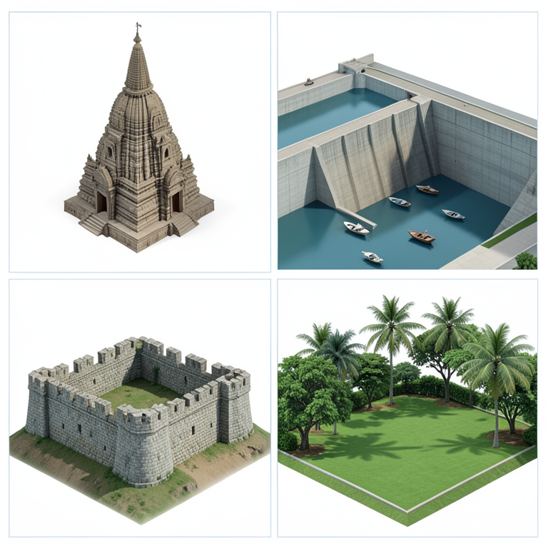
Categorization of Tourism Assets
AI-generated conceptual illustration (Landscapes of Dhule district, Maharashtra). It explains the idea and does not show study data.
View source evidence ↗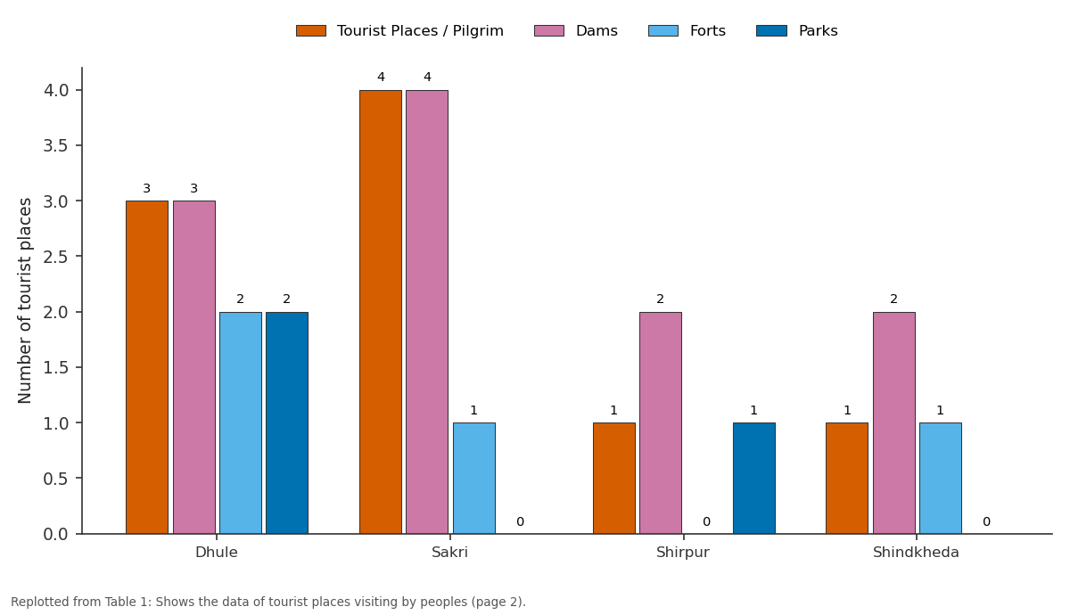
Tourist Places / Pilgrim and Dams and more: Dhule vs Sakri vs Shirpur vs Shindkheda
Replotted from Table 1 (page 2) of the original paper. Every bar is the paper's own table value.
View source evidence ↗Figures & tables
From the original paper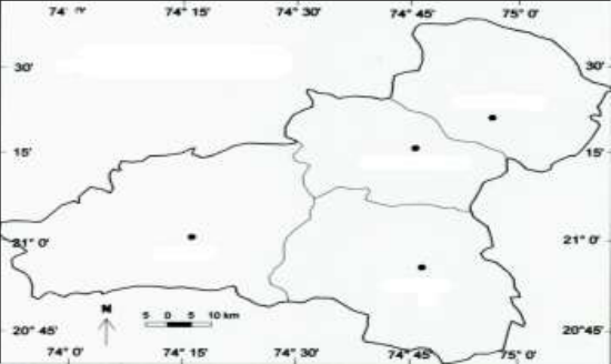 Figure 1
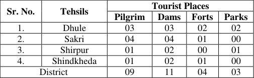 Table 1
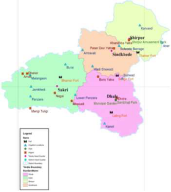 Figure 2
Introduction
Study area Study area is located in Northern part of Maharashtra state spread between Latitude 20° 38 to 21° 16 N. and Longitude 73° 50 to 75° 11 E. Dhule district is bounded by the district, Jalgaon is located to the East, Nashik to the South, Gujarat State and Nandurbar district is located to the North-West. Dhule district has an area of 7195 sq. km, and contributes 2.62% area of the Maharashtra State. Dhule includes four tehsils namely (1) Dhule (2) Sakri (3) Shindkheda (4) Shirpur. (Fig. 1).
Fig 1: Dhule district: Location map IJGGE 2024; 6(1): 53-55 Vandana Jijabarao Patil Research Student, Shri. J.J.T. University, Rajasthan, India Patil Shivaji Bansilal Head and Research Guide, Department of Geography, Late Annasaheb R.D. Deore Arts and Science College, Mhasadi, Sakri, Maharashtra, India Vandana Jijabarao Patil Research Student, Shri.
J.J.T. University, Rajasthan, India https://www.geojournal.net/ Physiography Most part of the Sakri and Dhule Tehsil is occupied by Dhanora and Galana hills. Hanuman is the highest peak on Galana hills, Kondaibari and Laling Bari are minor Ghats in the district. ‘Babakuvar’ is the highest peak in Shirpur Tehsil (811 M.) Bijasan Ghat is the North East of Shirpur Tehsil. Central and Eastern part of the district is occupied by fertile plain.
Shindkheda, Shirpur and Dhule Tehsil are included in central fertile plain. Tapi is the major river in the study area. It enters from Jalgaon District and flows from East to West. Aner and Arunavati are the major tributaries join from Western bank, whereas Panzara, Burai, Amaravati Join to the Tapi from the southern bank.
Panzara is the largest tributary of the river Tapi. Therefore, most part of Dhule District is made fertile by the tributaries of Tapi River. Soil of the district is fertile black cotton. The area along Tapi and her tributaries shows deposition of black cotton soil.
Mountainous region of the hilly area is sandy soil. Soil of the study area is divided in to three major types: 1) Deep Black Cotton soil (2) Medium Black soil (3) Course Shallow soil. Tourist Places Tourist places include forts, Pilgrim centers, Dams and parks in the district, there are many tourists interested places in the district are as follows. Table 1: Shows the data of tourist places visiting by peoples Pilgrim Centers In the district there are 09 pilgrim center i.e.
| Sr. No. | Tehsils | Tourist Places | — | — | — |
|---|---|---|---|---|---|
| Pilgrim | Dams | Forts | Parks | ||
| 1. | Dhule | 03 | 03 | 02 | 02 |
| 2. | Sakri | 04 | 04 | 01 | 00 |
| 3. | Shirpur | 01 | 02 | 00 | 01 |
| 4. | Shindkheda | 01 | 02 | 01 | 00 |
| District | 09 | 11 | 04 | 03 |
Table text extracted from the original PDF; superscript letters are shown inline. The original table image is below.
View original table image
Dhaner Amali, Nagai, Balsane, Dhule, Shirpur Mhasadi, Boris are of public interest tourist centers. In such centers people visit in a year. These centers are useful for cultural interaction. At the time of annual festivals people from the different part of Maharashtra are gathered for their cultural activities.
Dams - In the district there are 11 medium and number of minor dams like Wadishewadi Malgaon, Nakane, Aner, Sonwad, Latipada, Gondur, Katarkhadak, Akkalpada, Dedargaon are of public interest. In these areas’ natural scenery, different types of Birds, flowers and Wild animals, boating attract tourist. Tourist stay there for the Healthy climate, free from the hustle and bustle. Malgaon, Nakane, Aner, Sonwad, Latipada, Gondur, Katarkhadak, Akkalpada, Dedargaon are of public interest.
In these areas’ natural scenery, different types of Birds, flowers and Wild animals, boating attract tourist. Tourist stay there for the Healthy climate, free from the hustle and bustle. Forts Another interesting tourist center in the district is the forts. In the district Thalner, Laling, Bhamer and Songir are the historical forts.
Laling forts has a greater important, Dr. Babasaheb Ambedkar visited and stay there. Large number of people visits to forts for knowing the history of the region. These forts are located in well-connected road routes.
Parks In the district parks like Shirpur, Gondur, laling are greater important. People visit there for the freshness of mind. People stay there and enjoy the natural scenery. Sr.
No. Tehsils Tourist Places Pilgrim Dams Forts Parks 1. Dhule 03 03 02 02 2. Sakri 04 04 01 00 3.
Shirpur 01 02 00 01 4. Shindkheda 01 02 01 00 District 09 11 04 03 Source: Compiled by the researcher Fig 2: Location of tourist center in Dhule district https://www.geojournal.net/
Conclusion
Formerly study region comes under tribal zone of Maharashtra state. Study region also comes under the rain shadow zone. Agriculture is the prime activity of the district. No large-scale industries are there.
Considering all the facts that study region has a greater scope for tourism development. It also helps to agriculture economy and unemployment problem of the study area. With the planed government scheme some Tourist centers are developed i.e. Gondur Dam.
In the district large tourist center are not available but small places attract tourist. In the district there is a large scope for the development of tourist centers but there is a need of planned programme for the development of such tourist centers.
References
8 in the original paper- Dastane S. Maharashtra. Pune: Dastane and Company; c2010.
- Patil SB. Geomorphology & Settlements in Dhule district [Ph.D. thesis]. Jalgaon: KBCNMU; c2009.
- Patil BD, Patil YV. Agricultural Modernization in Dhule & Nandurbar District. The National Geographical Journal of India. 2007;53:57-64.
- Patil SB, Chaudhari SB. Slums in Dhule city: A Geographical Analysis. Golden Res Thought. 2015;5(1):1-4.
- Patil VS. Geographical study of population characteristics in Dhule district (MS) [Ph.D. thesis]. Rajasthan: J.J.T. University; c2013.
- Patil SB, Bawane SN. Changing agricultural technology in Dhule district: A Geographical study. Journal of Research and Development. 2023;15(19):16-19.
- Patil MA, Patil SB. Impact of Population growth on land use and environment: A study of Dhule district. Journal of Research and Development. 2023;15(19):119-122.
- Nandre HS, Patil SB. Decadal growth of Population in Dhule district: A Geographical analysis. Journal of Research and Development. 2023;15:210-213.