
Research article · 2023 · Full text
International Journal of Geography Geology and EnvironmentEnvironment problems of the Aral Sea basin in central Asia and its impact on society, economy, and regional security
Volume 5(1) · Pages 211–226 · DOI: 10.22271/27067483.2023.v5.i1b.191 ↗
Research areasTransboundary Water Resource ManagementRangeland Management and Livestock EcologyPolitics and Conflicts in Afghanistan, Pakistan, and Middle East
Abstract
Author-writtenThe Aral Sea, situated among five Central Asian republics, has dramatically shrunk over the last 60 years, causing catastrophic socio-economic and environmental consequences. Anthropogenic activities, stemming from industrialization and competition since the Tsar era, intensified during the Cold War, disrupting the self-regulating Aral Basin hydraulic system. This article delves into the multilayer factors contributing to the Aral Sea crisis, tracing back to Soviet dreams of cotton cultivation that led to the disappearance of a vast inland lake. The construction of canals for artificial irrigation caused the dried seabed, resulting in dust storms and reduced freshwater availability. The collapse of the fishing industry led to unemployment and migration. Climate changes and unsustainable water exploitation from the Amu Darya and Syr Darya rivers compounded socio-economic problems. Despite the initial focus on sustainable exploitation, this study emphasizes the overlooked impact of the Aral Sea crisis on regional security. In this article, I tried to draw a picture in to reflect on the multilayer factors that resulted in the crises of the Aral Sea. The most disastrous environmental catastrophe of the 20th century is often referred to as “Unknown Chernobyl.” I stretched back to the history of Soviet dreams that aimed to create a land of heaven in the deserts to fill it with white gold, i.e. cotton; initially successful but resulted in the disappearance of one of the largest inland lakes in the world. So, this paper also explores the impact of the Aral Sea crisis on regional security, which got less academic attention. All these issues remained a major focus of my study.
Summary
Source-checkedPlain-language reading of the full paper, prepared with AI and checked against the text. Each point links to the authors' own words.
Why it matters
- The Aral Sea, located across five Central Asian republics, has experienced a dramatic shrinkage over the last 60 years, leading to severe environmental and socio-economic impacts. View evidence ↗
- The creation of artificial irrigation canals led to the drying of the seabed, which in turn caused dust storms and a decrease in available freshwater. View evidence ↗
- Water shortages in the region have intensified competition over shared aquifers and rivers, creating geopolitical tensions that threaten Asia's economic growth. View evidence ↗
The question
- The study aims to investigate the various dimensions of the Aral Sea Basin's environmental problems and how these impact society, the economy, and regional security. View evidence ↗
What they did
- The research utilizes a qualitative design based on primary data from government archives, satellite imagery, and expert interviews, as well as secondary sources. View evidence ↗
- Water inflow and surface area data for the Aral Sea and its feeding rivers, the Amu Darya and Syr Darya, were sourced from the CAWater-IS system. View evidence ↗
What they found
- The surface area of the Aral Sea dropped from 65,607 km² in the 1950s to 36,562 km² in the 1990s, leaving it at approximately 55.67% of its original size. View evidence ↗
- The fishing industry collapsed as yields fell from 43,430 metric tons in the 1960s to 17,400 tons in the 1970s, eventually stopping entirely by the 1980s. View evidence ↗
- Biodiversity declined significantly, with mammal species dropping from 70 to 30 and bird species decreasing from 319 to 168. View evidence ↗
- The sea's shrinkage altered the local climate, causing shore station temperatures to rise by 1.5-2.5 °C in summer and winter, and diurnal temperatures to increase by 0.5-3.3 °C. View evidence ↗
- Land degradation has been severe, with 66% of Kazakhstan's land degraded and 15-20% of it becoming desert. View evidence ↗
- Between 2001 and 2009, land degradation caused an annual economic burden of approximately US$ 5.85 billion for the region. View evidence ↗
- Public health has suffered, with infant death rates in parts of Karakalpakia exceeding 100 per 1,000 live births, which is four times the former USSR national rate. View evidence ↗
What it means
- The author concludes that more comprehensive measures are needed to conserve the remaining North Aral Sea and its surrounding small water bodies. View evidence ↗
- The author recommends implementing drip irrigation to increase water flow into the sea and promoting crop rotation and diversification. View evidence ↗
Visual summary
3 visualsIllustrations explain the paper; charts are replotted from the paper's own table values.
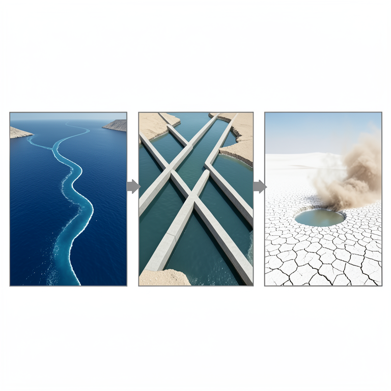
The Cycle of Desiccation
AI-generated conceptual illustration (The Aral Sea basin landscape). It explains the idea and does not show study data.
View source evidence ↗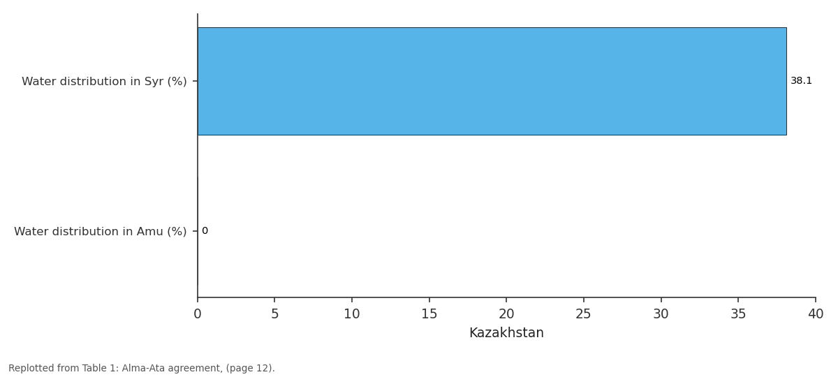
Kazakhstan: Water distribution in... vs Water distribution in...
Replotted from Table 1 (page 12) of the original paper. Every bar is the paper's own table value.
View source evidence ↗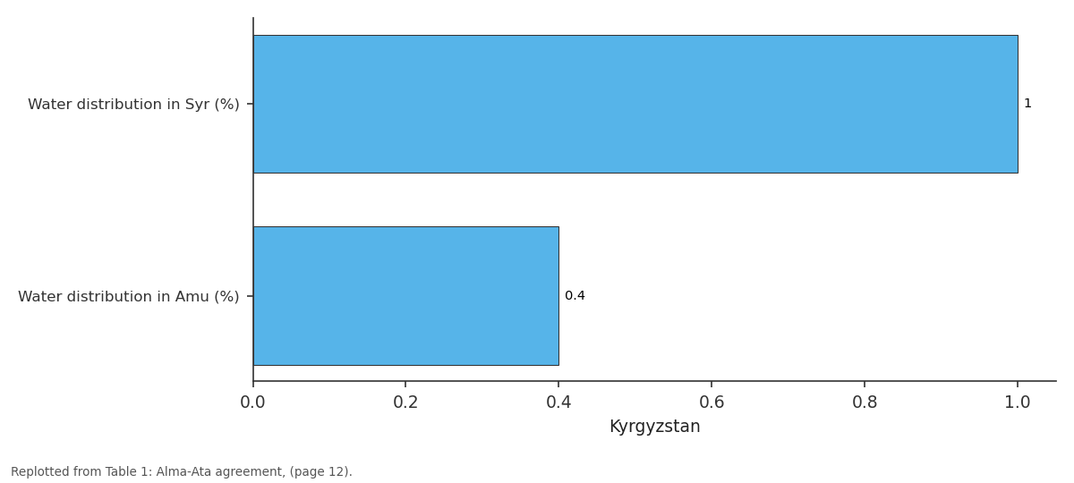
Kyrgyzstan: Water distribution in... vs Water distribution in...
Replotted from Table 1 (page 12) of the original paper. Every bar is the paper's own table value.
View source evidence ↗Figures & tables
From the original paper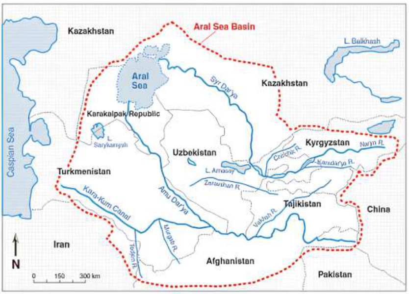 Figure 1
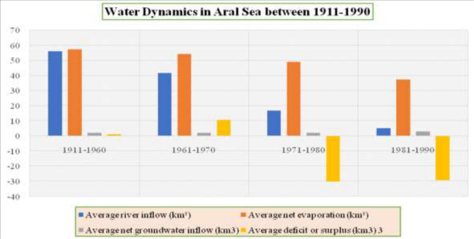 Figure 2
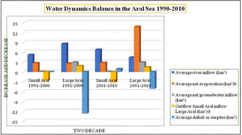 Figure 3
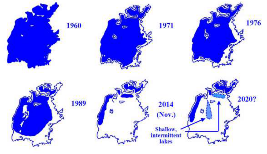 Figure 4
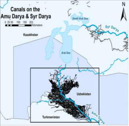 Figure 5
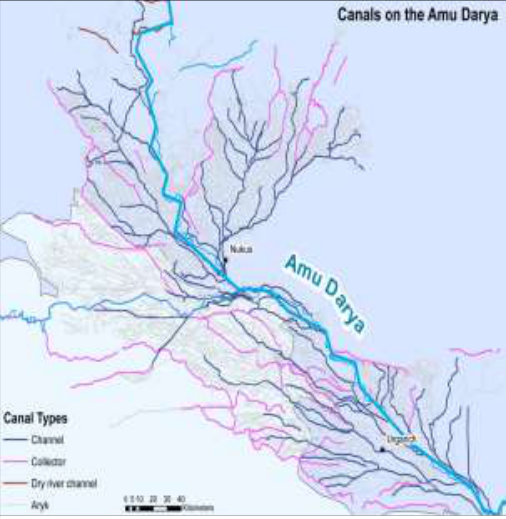 Figure 5
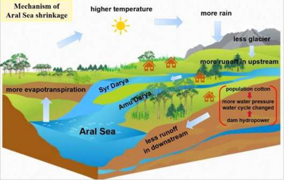 Figure 6
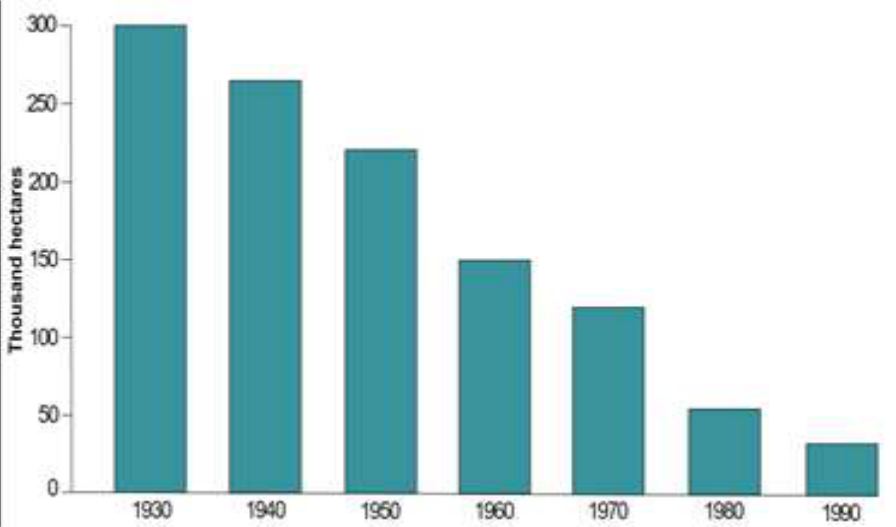 Figure 7
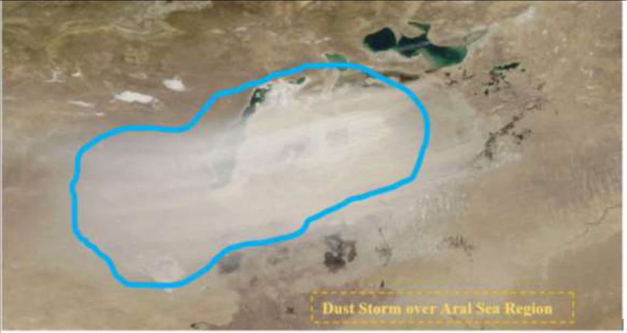 Figure 8
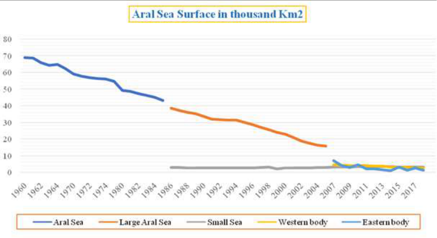 Figure 9
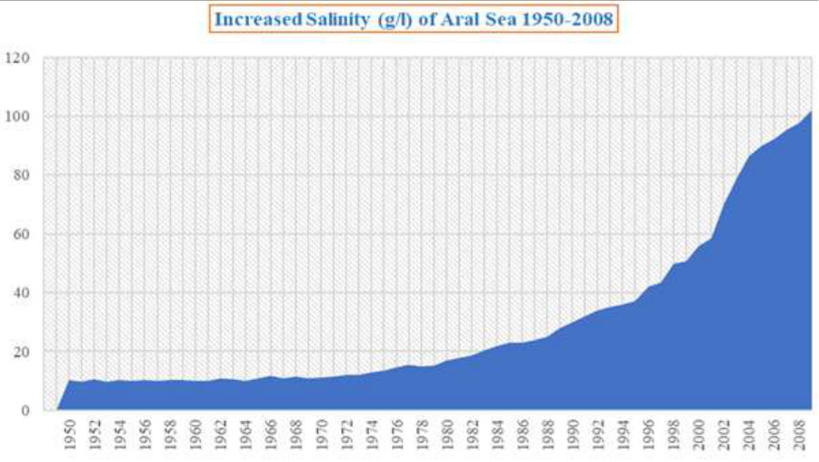 Figure 10
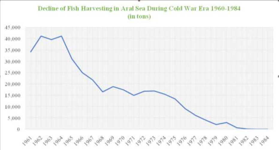 Figure 11
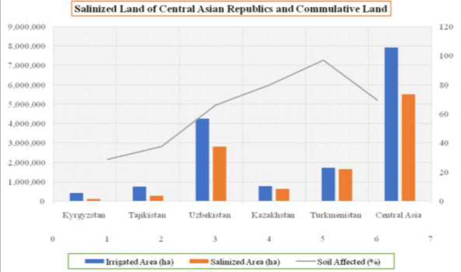 Figure 12
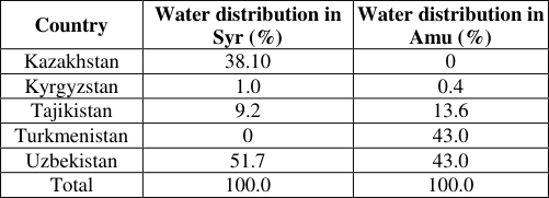 Table 1
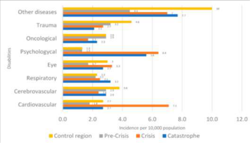 Figure 13
Introduction
The Aral was a pearl in the desert and a hope of life in the arid and humid region of Central Asia. The Aral Sea provided great employment opportunities for the local population before its desiccation. The two arms which give life to the Aral Sea life are the river Amu Darya and the Syr Darya. The Aral Sea is basically an endorheic lake whose survival lies upon these rivers. Fed by the Amu Darya and Syr Darya rivers, the Aral Sea maintains low salinity levels, creating a fish-friendly environment. Before the 1960s, the region's economy relied heavily on the fishing industry, muskrat farming, fish processing, ship servicing, and water transportation. The Aral Sea provided great employment opportunities for the local population before its desiccation. Inasmuch as to say, the Aral Sea fishing industry played an important role in the Soviet economy. The importance of the Aral fishery can be understood from the story that Lenin had asked the fisherman of Aral to send the fish to the famine-ridden Volga region. In response, they sent the 14-railway wagon of fish to the region, which saved millions of lives. The river Syr Darya and the Amu Darya before the 1960s brought approximately 50 km 3 of water annually to the Aral Sea (Erdinger et al., 2011) [17] . The surface water area of the Aral Sea was 65607 km 2 in the 1950s and decreased to 36562 Km 2 in the 1990s, which was about 55. 67 percent of the 1950s level. Further, from 1980 to 1999, the average inflow of water in the sea fell dramatically to 3.5 to 7.6 km3/year annual runoff. Many Russians since the tsar era have given considerable thought to the exploitation of the Amu Darya and Syr Darya as they considered that these rivers uselessly inflow into the Aral Sea. In 1888, an anonymous author writing for the journal "Russian Herald" wrote, "Every drop of water that pours off into the sea takes away as much life from the nearby desert" (Obertreis, 2017, p. 83.) [41][42] .
Similarly, A.I. Voeikov wrote in his report 'The Rivers of Russia' wrote; The existence of the Aral Sea within its present limits is evidence of our backwardness and our inability to make use of such amounts of flowing water and fertile silt, which the Amu and Syr rivers carry (Zonn, 2009) [69-70-73] .
Fig 1: Location of Aral Sea Basin in Central Asia
Soviet development aimed to transform deserts into fertile fields through extensive irrigation projects, dams, and canals. The cultivation of cotton expanded significantly from 1913 to 1940, leading to large-scale irrigation projects diverting substantial water from the Amu Darya and Syr Darya rivers. This resulted in a drastic reduction of river water inflow into the Aral Sea, decreasing from 30.0 km3/year in 1965 to 3.5 to 7.6 km3/year between 1980 and 1999. Overexploitation caused the Aral Sea to shrink, splitting into the "Small" and "Large" Aral Seas in 1987-89. By 2005, satellite imagery revealed the Large Aral Sea had fragmented into three water bodies, forming a man-made desert called Aralkum. The Aral Sea catastrophe had created multifaceted problems in Central Asia. This includes large-scale environmental degradation, salt and dust storms, salinization, land degradation, numerous health problems, decreasing water freshwater availability, economic loss, and risk to regional security. The shrinkage of the Aral Sea results in enormous health issues in the region. Some of these are direct consequences of the sea's recession, like respiratory and digestive afflictions and possibly cancer from inhalation and ingestion of blowing salt (Micklin, 2007a) [30] . Moreover, the food chain and local water supplies have been contaminated by salt and pesticides. Humans and farm animals are born with severe handicaps and diseases (Stevenson, 2012) [60] . The economic impact is no less tremendous than the health crises. The fish industry wholly collapsed due to the shrinkage of the Aral Sea. In the 1960s, fishing in the Aral Sea yielded 43,430 metric tons of fish, plummeting to 17,400 tons in the 1970s and ultimately ceasing in the 1980s. Scholars like Kasperson et al. (1995) [22] reported a decline in mammal diversity from 70 to 30 species and bird species from 319 to 168 in the Aral area. The Aral Sea conflict significantly impacts regional security, especially regarding Central Asian water shortages. Upstream nations like Kyrgyzstan and Tajikistan use water for hydropower, while downstream countries like Uzbekistan, Turkmenistan, and Kazakhstan prioritize water for agriculture. Historical Soviet-era goals favor irrigation over equitable distribution in the Syr Darya and Amu Darya basin, creating competing interests among regional nations.
Significance of the study
The development in unsustainable ways made human life not only vulnerable to natural disasters but also increased human-induced risk to society. The significance of addressing the environmental problems in the Aral Sea Basin is multifaceted, encompassing environmental sustainability, human well-being, and regional stability. Water shortages have not only stirred geopolitical tensions by intensifying competition over the resources of shared rivers and aquifers, but they also threaten Asia's continued economic rise (Chellaney, 2014, p.621) [10] . As Ban Ki Moon correctly said, "Water scarcity threatens economic and social gains. It undermines environmental sustainability. It slows progress towards the Millennium Development Goals. And it is a potent fuel for wars and conflict". The potential for conflict over scarce water resources in the region underscores the importance of addressing environmental issues. Collaborative efforts in water management can help prevent tensions and conflicts among the countries sharing the Aral Sea basin. Central Asian states, including Kazakhstan, Kyrgyzstan, Tajikistan, Turkmenistan, and Uzbekistan, confront significant waterrelated challenges with a potential for conflict. A 2014 United Nations report, "Glaciers Melting in Central Asia: Time for Action," highlights the rapid melting of glaciers in Kazakhstan, Tajikistan, and Kyrgyzstan, leading to a water imbalance in the Aral Sea region. This further intensified conflicts among states and created a challenge to regional security. The population of Central Asian countries has increased five times in the last seven decades. So, the demand for food and water intensified over the years. This leads to the expansion of irrigated agriculture in the region, further intensifying multilayered crises in the Aral Sea Basin. The Aral Sea crisis has gradually transformed into a transboundary catastrophe in Central Asia. To tackle the socio-economic and environmental problems in the region, the upstream and downstream countries come together to take shared action to preserve the Aral Sea in order to solve the water crises in the region. The decision taken by regional organizations like the International Fund for Saving the Aral Sea (IFAS) must be mutually agreed upon by the nations. Further, world leaders from developed countries and organizations like the United Nations and the World Bank provide a platform for discussion and provide funds and scientific, technological, economic assistance, and other necessary tools to come out of the crises and to follow a sustainable way of development. The case of the Aral Sea serves as a global example of the consequences of unsustainable water management and environmental negligence. Studying and addressing the issues in the Aral Sea Basin contribute to global awareness and understanding of the importance of responsible environmental stewardship.
Objectives of the Study
The primary objective of this comprehensive research study is to investigate the multifaceted dimensions of the Environment Problem of the Aral Sea Basin in Central Asia and its Impact on Society, Economy and Regional security. To achieve this overarching goal, the study is guided by the following specific objectives: 1. To examine historical root causes of Aral Sea basin water shrinking in Central Asia. 2. To study the environmental factors responsible for desertification of Aral Sea Basin. 3. To discuss the emerging dreams of modernization through USSR Colonization of CARs. 4. To evaluate the environmental changes and ecological disaster in the Aral Sea Region. 5. To observe the social economic condition effected by Aral Sea water crises in CARs. 6. To examine the dispersion of saline particles emanating from the exposed lake bed poses potential health hazards to the local population. 7. To highlight the water crises creating a threat to regional and environmental security of Central Asia.
Materials and Methodology
The study is based on primary and secondary sources of information. The primary data was taken from government archives and reports and satellite images, interviews of experts etc. The data on the surface water area of the Aral Sea and the inflow of water in the Amu Darya and Syr Darya were taken from the Regional Information System on Water and Land Resources in the Aral Sea Basin (CAWater-IS). The secondary data sources include research reports, books, articles, thesis, magazines, research papers, and internet sources. This research employs a qualitative design and uses a multimethod approach to provide a comprehensive examination of the Environment Problems of the Aral Sea Basin in Central Asia and its Impact on Society, Economy, and Regional security. On the basis of objectives and review of vast literature analysis the issue discusses on Aral Sea environmental crises in Central Asia. The qualitative research is primarily evaluated and analytical in nature which derives much of its information from myriad of secondary sources. The discussion about qualitative research tries to understand the determinants of research as a whole wherein they are interrelated to each other in many different ways.
Results and Discussion
The Aral Sea has a history of fluctuation in surface area water for centuries. [56] show that due to the prolonged melting of ice in glaciers in the Tien Shan Mountains had reduced water availability. Wang et al., (2016) [63] argued change in precipitation was the dominant reason for the change in stream flow in the tributaries and the mainstream of the Amu Darya River. He further showed stream flow decreased by 15.5% because of the decline in precipitation. However, (Austin et al., 2007) [75] used diatom-inferred Palaeo-conductivity to study the regression of the Aral Sea over the last 1600 years. They divided the regression of the Aral Sea into three distinct phases (i) ca. AD 400, (ii) ca. AD 1195-1355, and (iii) ca. AD 1780 to the present. They argued that the first two regressions may be linked to the natural diversion of the Amu Darya away from the Aral Sea and the failure of cyclones formed in the Mediterranean to penetrate more continental regions. The Amu Darya contributed almost 80 percent of hydrological input into the Aral Sea. Any fluctuation in the course of river Amu Darya impacted the water input in the Aral Sea. The research done by (Shermatov et al., 2004) [76] showed that increased solar activity resulted in a decrease in the Amu Darya discharge into the Aral Sea. However, water inflow of the Amu Darya River into the Aral Sea declined naturally but the present regression has been a direct result of human activity (Austin et al., 2007; Kes, 1995) [75] . [69-70-73] . To describe the intensity of the Aral Sea catastrophe, which was the result of human exploitation of nature in unsustainable ways, scholars like (Edelstein, Cerny, and Abror Gadaev, 2012) [15] used the term "Disaster by Design" to describe the Aral Sea Catastrophe. The inflows of water by the Amu Darya and Syr Darya in the Aral Sea maintained the balance of water lost due to evaporation. During the first six decades of the twentieth century, the sea's water balance was remarkably stable, with annual river inflow and net evaporation never far apart, resulting in lake level variations over this period of less than 1 m (Micklin, 2014) [32] .
Fig 2:
Water Dynamic in Aral Sea between 1911-1990, Data Source: (Micklin, 2014) [32] The fact is that between 1960 and 1988, Soviet raw cotton production increased from just less than 4.3 million tons to 8.7 million tons (White, 2013) [67] . The growing need for irrigation resulted in a significant surge in water consumption, leading to extensive withdrawal of water from the Amu Darya and Syr Darya river basins. We can see from the above data water imbalance after the 1960s and till the 1990s, the average water deficit in the Aral Sea reached negative. Even after the collapse of the Soviet Union, the land under cultivation extensively increased, resulting in further shrinkage of the Aral Sea (Li et al., 2021) [27] .
The irrigated land area surged from around 5 million hectares in 1960 to 8.2 million hectares in 2010, surpassing sustainable levels and leading to a decline in compensatory effects. This rapid irrigation development significantly reduced river discharge into the Aral Sea, causing its shrinkage. Despite conservative measures taken in the 2000s to restore the Aral Sea, it continued to diminish, as decreased river inflow and increasing net evaporation, particularly affecting the Large Aral Sea.
Fig 3:
Data Source: (Micklin, 2014) [32]
The surface area of the Aral Sea was about 68,000 km 2 before 1960 (Micklin, 2007b; Cretaux et al., 2018) [31,11] .
There was a decrease of 7727.19 km 2 between the years 1989 and 1996, followed by a larger decrease of 11504.74 km 2 between 1996 and 2002. Between 2002 and 2010, the reduction in area was 7912.52 km 2 , and from 2010 to 2017, it further decreased by 3314.21 km 2 (Deliry et al., 2020) [12] .
Fig 4:
Shrinkage of Aral Sea since 1960s, Data Source: (Micklin, 2016) [33] As previously stated in this research, the Aral Sea has been significantly desiccated, resulting in its dispersion into many smaller basins. The Aral Sea was divided into two entities by the 1980s: the Small Aral (or North Aral) and the Large Aral (or South Aral). The Small Aral was eventually repaired once the Bering Strait dam was built, while the Large Aral continued to diminish. The Large Aral was further subdivided into two additional water bodies between 2010 and 2012: the Southeastern Aral and the Southwestern Aral (Cretaux et al., 2018) [11] . Since 2018, the Aral Sea has consisted of five small bodies. Despite the more or less stable water level in the Small or North Aral Sea, a huge dried sea bed emerged in the Large Aral Sea known as the Aralkum desert. It had a severe negative impact on Central Asian states. The ecological properties of the dried sea have changed. The desiccated seafloor constitutes a vast expanse of open, often barren terrain, brimming with high concentrations of salt. Unfortunately, this area has now emerged as a primary origin for salt dust storms and salt blowouts, thereby contributing to salt contamination of the surrounding cultivated lands in Kazakhstan and Uzbekistan. Despite its hazardous impacts on the ecological system, the scope and the implications of the salt-dust export on plants, animals, and humans remain only partially comprehensible.
The further hazardous impact of dust storms on human health in the Aral Sea region is discussed in the later part of the paper.
Transformation in the Soviet and the Crisis of the Aral Sea
The Aral Sea crisis became visible in the 1960s, but the root of this catastrophe can be traced to Tsarist rule in the late 19th century, which continued in the Soviet era. Before the arrival of imperial Russia, the population living in the region of the Aral Sea was predominantly nomadic. Glukhovskoi, a Russian general, argued: "whether or not the preservation of the Aral Seathis dead reservoir of bittersalty waterwas necessary for the Empire." He further suggested reviving the old bed of Amu Darya and irrigating deserted steppes west of the Khanate of Khiva. The Soviets aimed to give competition to the West and, dreaming of making the desert bloom with cotton and, to a lesser extent, rice, diverted water from the rivers into vast irrigation projects (Wheeler, 2021) [65] . Obertreis also argued that Bolsheviks in particular had promised that irrigation and cotton would bring modernity to Central Asia. Similarly, Maya K. Peterson had shown that "the drying of the Aral Sea, a major environmental disaster of the late twentieth century, is deeply rooted in the dreams of the irrigation age of the late nineteenth and early twentieth century's, a time when engineers, scientists, politicians, and entrepreneurs around the world were united in the belief that universal scientific knowledge, combined with modern technologies, could be used to transform large areas of the planet from 'wasteland' into productive agricultural land". The lust for white gold increased in the post-war periods. Consequently, from 1958 to 1990, cotton production in the Canal Zone of Turkmenistan saw a 4.5-fold increase. In 1990, the Canal Zone was responsible for producing half of the 1,457 thousand tons of raw cotton harvested in Turkmenistan, including all types of high-quality fine-fiber cotton varieties (Zonn, 2014) [72] . Not only cotton but also wheat and rice had been cultivated in Central Asia since ancient times, and Central Asian people used a highly sustainable crop rotational system by growing cotton for one year, alfalfa the next, and allowing the land to be used as pasture for animals in the third year. This agricultural technique contributed to improved soil fertility and yielded higher crop yields in the long run (Loodin, 2020) [28] . But as the Cold War intensified the burden on agriculture increased, and these crops became strategically important to the Soviet economy, resulting in the overexploitation of land and water to produce more of them under the so-called "Great Stalin Plan for the Transformation of Nature in the USSR". Consequently, a huge canal project was executed in the Aral basin like the Shirin Canal. Shirin Canal drew water from the Syr Darya's surging waves, and its large water was diverted to Kizil-Orda in Kazakhstan and the area near Tashkent in Uzbekistan for agricultural uses (Kumar, 2002) [25] . As in 1939 Usman Yusupov, the First Secretary of the Central Committee of the Communist Party of Uzbekistan argued;
We cannot resign ourselves to the fact that the waterabundant Amu Darya River carries its waters to the Aral Sea without any use, while our lands in the Samarkand and Bukhara regions are insufficiently irrigated. To bridle the Syr Darya and Amu Darya rivers, to control them and to make their water serve the cause of socialism, for the purpose of raising the living standards of population and developing the country (Zonn, 1999) [71] . The policy of building extensive artificial irrigation continued under the Khrushchev and Brezhnev periods to produce more cotton. Under the so-called" Virgin Land
Policy" Khrushchev promoted the irrigation of 500,000 hectares in the Hungry Steppe, which was already proposed by Rizenkampf in his plans of 1912 and 1921 (Peterson, 2019) [44] . As pointed out earlier, the Cold War also exuberated tension in the economy, and thus the USSR intensified cotton-cultivation. Khrushchev proposed a new target of producing 3 million m etric tonnes of raw cotton by the year 1960 in Uzbekistan.
To create fresh cotton acreage, orchards and vineyards had to be removed. He also aimed to increase cultivated cotton by 200,000 ha and 100,000 ha in Uzbekistan and Kazakhstan, respectively. The Karakum Canal was constructed to divert water from the Amu Darya into Uzbekistan and to the Turkmenistan's southern arid areas for cotton and rice cultivation. Consequently, the cotton cultivated area increased from 1,427,900 hectares in 1960 to 1,709,200 in 1970, reaching around 2,000,000 hectares in the early 1980s (Spoor, 2007b) [59] . Similarly, the creation of an artificial irrigation system in Fergana Valley which had a network of 400 canals in the lower reaches of the Syrdarya River, irrigate more than 70,000 hectares of land. This had a direct impact on the desiccation of the Aral Sea (Abdullaev, 2021). The below image shows how canals drained water from Amu and Syr Darya which cut the two arms of the Aral Sea, and eventually put it to death. [15] Between 1965 and 1985, irrigation in the Aral Sea Basin significantly expanded, reaching nearly 7 million hectares.
The rapid growth in irrigation-based agriculture, primarily for cultivating cotton, rice, wheat, and vegetables, is a major factor contributing to the desiccation of the Aral Sea, as agriculture alone accounting for 87 percent of the region's total water demand. Uzbekistan which is one of the world's top ten cotton producers continues push to cotton cultivation. A cotton farmer in Uzbekistan told a reporter, "We are harming ourselves" (Beckert, 2014) [7] .
Environmental changes and Ecological disaster in the Aral Sea
Reznichenko, director of the Aral-88 expedition in 1989, had rightly argued that Aralsk is situated in the epicenter of an ecological disaster. The Aral Sea was home to over 38 different species of fish, and the forests and hinterland that encircled it were teaming with a diverse array of birds and other wildlife, such as deer, gazelles, Asiatic cheetahs, lynx, and even Caspian tigers now all had gone (Stevenson, 2012) [60] . The environmental impact of the Aral Sea spans over 400,000 square km. By the late 1980s, the territory covered by lakes, wetlands, and reed ecosystems had decreased by 85%. The Tugai environment, characterized by a diverse array of plant species totaling 576, has a notable presence of 29 plant species that are unique to the Central Asia area (Novikova, 1999) [50] . The population of the Bukhara Deer (Cervus Elaphus bactrianus), which was once distributed over the riverine habitats of Central Asia, has significantly declined to a mere 300 individuals. Based on the research conducted by Dr. Novikova in 1999 [50] , it can be shown that the coverage of Tugay in the Amu Darya delta underwent a significant reduction over time. Specifically, in 1950, Tugay covered an area of 100,000 hectares. However, this coverage decreased to 52,000 hectares by the 1970s and declined to a mere 15,000-20,000 hectares by the mid-1990s. Lakes and wetlands serve as crucial habitats for this diverse range of animals and for birds like migratory waterfowl. However, the decline of these habitats, along with the escalating pollution of the remaining water bodies, mostly due to the influx of fertilizers, pesticides, and herbicides from irrigation runoff, has resulted in a significant reduction in aquatic bird populations (Micklin, 2015) [36] . According to Philip Micklin, there were 100,000 hectares of marshes in the region in the 1960s, reduced to 15,000 in the 1990s, and the number of fish declined to 6 from 32. The bird species declined from 319 to 160 and that of mammal species from 70 to 32 (Plotnikov et al., 2023) [46] . The shrinking of the Aral Sea also had a tremendous impact on the regional climate of Central Asia. During summer large amounts of evaporation keeps the temperature near the Aral Sea good before its shrinkage. The Aral Sea once acted as a regulator or mitigator of the chilly north winds from Siberia, decreasing summertime temperatures. Because of the massive Aral Sea's depletion, the region now experiences drier, shorter summers and longer, colder winters (Rudenko and Lamers, 2010) [49] . On the other hand, rapidly expanding desert has led to an increase in summer temperatures and a reduction in precipitation. Extreme frosts in the winter, with temperatures down below -40 degrees Celsius, are devastating to agricultural products (Stevenson, 2012) [60] . The intense heat of the Central Asian summer was mitigated by the Aral Sea when it was its original size and absorbed solar energy equal to seven billion metric tons of conventional fuel yearly. In cooler conditions, it reradiated this heat into the atmosphere (James Critchlow., n.d.) [21] . However, due to the shrinkage of Aral Sea, temperatures near shore stations increased by 1.5-2.5 °C in summer and winter, while diurnal temperatures increased by 0.5-3.3 °C. Annual relative air humidity decreased by 2-3%, reaching 9% in spring and summer (Kasperson et al., 1995) [22] . Another issue associated with the decrease in sea level and the consequent reduction in sea surface area pertains to the escalation in the quantity, frequency, and consequences of dust storms. In the year 1975, dust salt storms occurred 6-7 times a year, impacting an area of 350 -400 km (Vostokova, 1999) [62] . The desiccated bed of the Aral Sea has provided evidence indicating that the northeastern portion of the Aralkum Desert is a major contributor of airborne dust in the area, leading to elevated levels of aerosol concentrations in the atmosphere. The dust plumes emanating from the desiccated bed of the Aral Sea have shown an increase in size, while the intensity of dust storms has also escalated after the exposure of the sea's bottom. The primary alteration seen in the land cover was a notable decline in flora and tiny bodies of water, accompanied by a substantial rise in solonchaks (salty pans) and sandy massifs (Semenov, 2012; Spivak et al., 2012) [54,57] . However, the combination of salts in both dry and aerosol forms precipitating onto soils and plants has a detrimental effect on plant development and agricultural productivity. In some instances, it may even lead to plant mortality (Micklin, 2015) [36] . This natural-color picture of a dust storm over the onceextensive inland lake was acquired by the Moderate Resolution Imaging Spectroradiometer (MODIS) and was taken by NASA's Aqua satellite on March 24, 2020 (Ge et al., 2020) [19] . The blue circle marked by the author describes the area covered by dust storms (See. fig 8). The majority of instances (70%) were dust plumes that emanated from the eastern terraces that had undergone desiccation before 1999. Between the years 2005 and 2008, a significant quantity of dust plumes were found to originate from areas that had experienced drying before the 1990s, close to the water line established in 1960 (Indoitu et al., 2015) [20] .
Fig 8:
Dust Strom Over the Aral Sea Region, Data Source: (Ge et al., 2020) [19] , Picture modify by author
Socio-Economic Turmoil
The disintegration of the Aral Sea significantly altered the socio-economic landscape of the region. Data shows a clear link between environmental changes, severe weather, declining population health, and migration patterns. While agriculture remains crucial to Central Asia's economy, artificial irrigation has adversely impacted land-water resources, creating severe socio-economic challenges. The fishing industry, along with agriculture, food processing, canning, shipping, and navigation, once vital for local livelihoods, has been heavily affected. The Aral Sea constituted around 7% of the overall fishing production inside the internal seas of the USSR. The most commercially exploited species were roach (Rutilus rutilus aralensis), sazan (Cyprinus Carpio Aralensis), and bream (Abramis brama orientalis) (Sapozhnikov et al., 2010b) [52] . Due to a decrease in surface area due to the artificial irrigation system, subsequently increasing salinity (Aladin et al., 2019; Plotnikov et al., 2014) [2,45] of the Aral Sea, the fish industry was completely devastated (White, 2014) [68] .
Based on the findings of several research, it has been determined that a significant quantity of salts, amounting to about 150 million tons, is introduced into the Aral Sea.
Economic Impacts from the overuse of Irrigation
In 1975, the Kyzylorda oblast authorities wrote to the Kazakh Council of Ministers; The Aral waterbody is one of the oldest fishery basins in the country. In the past, on the Aral Sea, up to 500,000 tsentners (50,000 tonnes) of highquality table fish were extracted (zander, asp, carp, barbel, bream, roach). However, since 1965, the Aral Sea and the fishery lakes of the oblast, because of the sharp increase in the abstraction of water from the rivers Syr Darya and Amu Darya for agricultural needs, have been shallowing, which has led to a serious deterioration in the natural reproduction of fish stocks in the basin and reduction in the volume of fish catches quoted in (Wheeler, 2018) [64] .
In the 1960s the fish harvesting in the Aral Sea was approximately 43,430 tonnes by the 1980s they became zero. According to Struan Stevenson, 40 to 60,000 fishermen have lost their livelihoods, devastating those areas of Karakalpakstan that used to rely on fishing for up to 50 percent of their income. Before cotton monoculture, the Aral Sea region was green, but due to large-scale water withdrawn from the river resulted in desertification of the region.
Fig 11:
Decline of Fish harvesting in Aral Sea from 1960-1984, Data Source: (White, 2014) [68] The Aral Sea's decline has led to significant land salinization and degradation in the region, affecting crop production despite high fertilizer use. Excessive irrigation mobilized deep salt deposits, raising water tables and causing water logging, especially impacting Turkmenistan (95% of irrigated lands), Tajikistan (16%), and Kazakhstan (over 30% facing salinity and water logging challenges).
According to the UNCCD (1994), 66% of Kazakhstan's land has degraded, with 15-20% turning into desert. Salinization affects 89% of irrigated lands in Turkmenistan, with 12.7% heavily salinized. In Uzbekistan, the figures are 51.4% salinized and 5.7% heavily salinized. The process of agricultural development, coupled with excessive grazing of grasslands, has led to the formation of around 80 square kilometers of desert areas in Kazakhstan. Within the Tedzhen oasis, a significant proportion of the irrigated area, namely 48,000 hectares out of a total of 70,000 hectares, has been affected by salinization. In Turkmenistan, a significant proportion of irrigated land, namely 86.7 percent, is affected by salinization. In the Karakalpak Republic, about 377,000 hectares out of the total 485,000 hectares of irrigated land have been affected by salinization (Kasperson et al., 1995) [22] . Due to largescale salinization, the productivity of land decreased and resulted in huge economic loss. For example, according to Kuleshov (1985) [76] , there was a decrease in output from a hectare of irrigated land in the Gyaur area of Turkmenia. Specifically, the production decreased from 2,000-2,500 roubles to 1,500 roubles or less, over the period between 1978 to 1984. Some research has shown that during the period from 1970 to 1985, the Karakalpak Republic had a significant decline in labour productivity in the agricultural sector, with a reduction of 11 percent. Additionally, there was a substantial decrease in the gross output per hectare of irrigated fields during the same timeframe. This pattern is characteristic in several areas within the Aral Sea region.
According to a study conducted by researchers at the Institute of Water Problems, USSR Academy of Sciences (Problems of the Aral Sea 1973), it was anticipated that there would be a decline in the yearly gross revenue by an estimated range of 15-30 million roubles due to the alterations in the Aral Sea (Glazovsky, 1995) [77] . Between the years 2001 and 2009, the region had a significant economic burden amounting to about US$ 5.85 billion per year as a result of land degradation induced by unsustainable land use practices and the deterioration of crops and pasture areas. The expenses in Kazakhstan amounted to over 3.06 billion US dollars, while Turkmenistan had expenditures of 0.87 billion US dollars. Uzbekistan's costs reached 0.83 billion US dollars, Kyrgyzstan's costs were 0.55 billion US dollars, and Tajikistan's costs were 0.5 billion US dollars (Narbayep et al., 2022) [38] . According to a report published by UNESCO titles "Aral Sea and Aral Region '' report that land productivity in Prearalye is much lower compared to the overall productivity in Uzbekistan. The report stated that average land productivity in Prearalye was 250.3 $/ha in 1995, which was 2.2 times lower than the average of 559.8 $/ha in the republic. Similarly, in 2017, the land productivity in Prearalye was 691.3 $/ha, which was nearly 4 times lower than the average of 2,483.2 $/ha in the republic. Further, due to shortage of water, the crop acreage in Prearalye was reduced by 138,200 ha as compared to 1991 and totaled 148,900 ha in 2017. The output of some agricultural products, such as rice, raw cotton, and maize, has seen a significant decline due to reductions in both cultivated land and crop yields. For example, the output of rice has seen a fall of 3.7 times or a reduction of 198,900 metric tons in comparison to the year 1991. The production of raw cotton has decreased by 1.5 times or 45,000 metric tons, while the production of grain has decreased by 2.8 times or 7,300 metric tons. The report estimated the total combined socioeconomic costs resulting from the environmental catastrophe in Prearalye were calculated to be $144.83 million.
Human Health Crisis
The desiccation of the lake resulted in the introduction of fertilizers and pesticides into the progressively salty water via the flow of the river. Consequently, the dispersion of saline particles emanating from the exposed lake bed poses potential health hazards to the local population. It has the potential to diminish soil productivity in the immediate vicinity. In the context of cotton monoculture, significant quantities of fertilizers, defoliants, and herbicides were used on irrigated terrain. The pesticide known as DDT was extensively used in the area until the year 1982, and there continues to be a notable presence of DDT in the soil (Kasperson et al., 1995) [22] . As a result, there is notable rise in anaemia, TB, kidney and liver disorders, infections of the respiratory tract, allergies, and malignancies. According to reports, Karakalpakia, an autonomous republic located on the southern coastline of the Aral Sea, has infant death rates in some areas that exceed 100 per 1000 live births. This figure is four times higher than the national rate seen in the former USSR (Micklin, 1992; Stevenson, 2012) [36,60] . An This is because of the high use of pesticide during the period from 1980 to 1992; the pesticides, namely dichlorodiphenyltrichloroethane (DDT) and lindane was used in cotton fields in Uzbekistan and Karakalpakstan at a rate of 54 kilograms per hectare and 72 kilograms per hectare, respectively (Small et al., 2001; White, 2013) [55,67] . As a result, in certain areas, from the mid-1970s onward, there has been a 15-fold rise in the death rate, a six-fold increase in cases of cardiovascular disease, a six-fold increase in tuberculosis, a fivefold increase in gallbladder and gallstone diseases, and a seven to tenfold increase in cases of esophageal cancer (Kasperson et al., 1995) [22] . Sins of the Soviets are many in the Aral Sea region. Vozrozhdeniye Island in the Aral Sea was becoming a testing ground for the USSR from 1952 to 1991. A range of genetically engineered and weaponized diseases, including anthrax, plague, typhus, smallpox, and other disease-causing organisms, were subjected to testing. Now, with the dissection of the Aral Sea, the island came in touch with the mainland. Health experts suggest that there are possibilities for disruption of buried anthrax, such as via the activities of rodents, and subsequent transmission to the mainland, leading to infection among herbivores and humans, is a matter of concern (Micklin, 2007b [31,34,48,60,66] .
Fig 13:
The major disability structure of adults per 10,000 in the Aral Sea area from 2004-20, Data Sources: (Anchita et al., 2021b) [4] Despite the dissolution of the USSR and the implementation of various measures aimed at addressing the Aral Sea crisis, the decline in human health persisted in the region around the Aral Sea. A growth of respiratory diseases was detected in the catastrophe zone from 9467 diagnosed people (per 100 thousand population) in 1991 to 10,744 (per 100 thousand) in 2016, seen in the Kazakhstan region (Anchita et al., 2021a) [3] . The above graph provides insight into prevalent different diseases in the Aral Sea region from 2004-2020.
Regional security in Central Asia: a view through Aral Sea crisis
Central Asia is considered one of the corrupt regions in the world. Problems like drug trafficking remained an important challenge to regional security (Kumar, 2022) [23] , but the Aral Sea crisis and water mismanagement created newer forms of threat to regional security in Central Asia. Before the dissolution of the USSR, the Soviet Ministry of Land Reclamation managed the water resources in five Central Asian countries. The ministry divided these countries into upstream and downstream ones. The regulation of water flow and hydropower production was attributed to the upstream area, namely Tajikistan and Kyrgyzstan. On the other hand, the downstream regions, including Turkmenistan, Kazakhstan, and Uzbekistan, experienced expansion primarily for the purpose of cultivating cotton and extracting oil and gas (Loodin, 2020) [28] . Consequently, an interdependency developed among these countries, and harmony in resource distribution was maintained during the Soviet era. But, with the fall of the Soviet Union and due to the consequences of the Aral Sea crises, the structure that was developed no longer served the needs of independent states. Subsequently, the creating a threat to regional and environmental security. Water became an instrument of power and threat through downstream control. However, some consensus developed between the Central Asia states, and they agreed on the pre-existing mechanism and subsequently engaged in the Alma-Ata Agreement, which pertained to the allocation of water resources within the Aral Sea basin. [13] Water is a crucial resource for the 50 million people in the Aral Sea Basin, driving food security, biodiversity, and employment. With over 8.4 million hectares of irrigated agriculture contributing 20% to the regional GDP and employing 40% of the population, water is vital for overall development in the five Central Asian countries. However, conflicts arise due to national interests undermining agreements like Alma-Ata. The breakdown of the Soviet interdependency has led to competition over water resources, exemplified by Kyrgyzstan altering Toktogul reservoir operations for energy consumption, causing tension with downstream countries. Hydrocarbon-rich nations Uzbekistan, Kazakhstan, and Turkmenistan dominate the region's renewable water resources, emphasizing "historical rights." Regional conflicts also attract external players like the United States, further escalating threats to regional security and peace.
Results
We find that the large diversification of the rivers Amu Darya and Syr in the Soviet era resulted in the shrinkage of the Aral. This was due to the large-scale construction of artificial irrigation to produce more cotton and wheat. The irrigation projects like the Karakum Canal, Fergana Valley, and other such projects drew huge amounts of water from the Aral Sea Basin. In 1950, the collective extent of irrigated land in Central Asia was recorded to be 5.4×10 6, which reached 9.4 × 10 6 in the 70s. The desiccation of the Aral Sea brought multilayered problems in the Aral Sea region. The local economy of the region was completely devastated, and now towns like Muynak, which was once near the shore, now 200 km from the Sea. We have noted that health conditions worsened in the Aral Sea region with high morbidity rate, and disease like intestinal cancer prevailed in the region. Dust storms arising from the Aral Sea became a source of many respiratory diseases. These all factors impacted the GDP of the Central Asian states. The socio-economic loss in Paralyze amounted to $144.83 million. Further we find in the study that mismanagement of natural resource like water which considered more valuable than gold in arid region like Central Asia, resulted in threat to regional security.
Concluding Remarks
The reckless use of water triggered the 20th century's most significant environmental disaster the desiccation of the Aral Sea, once the world's fourth-largest lake. The former president of the Uzbek Academy of Sciences, Polat Habibullaev, rightly argued, "Until now, human history has not witnessed in the span of a single generation the disappearance from the Earth's surface of a sea which once had an area of 6 million hectares and its transformation into a barren land upon which no vegetation or form of life can be sustained." The root of this catastrophe lies in the Soviet dream to make deserts in blooming fields of cotton and rice, which goes back to the Tsarist era. Ivanovich Reznichenko, in 'My Znaem, argued Aral "Cotton had brought people no happiness. And the town offers nothing. Don't look for water pipes here, don't ask about central heating, gas, and don't count on any other conveniences or even insignificant social welfare." It applied the statement of Struan Stevenson to the Soviet Union as a whole till 1991 that under the USSR, the Aral Sea had been virtually drained; toxic dust storms raged across the landscape; humans have been exposed to anthrax, typhus, and other deadly bio-weapons; generations face illness and disease because of exposure to radiation; acute water shortages threaten regional conflict and the mass migration of environmental refugee. As we have seen above in the study, due to the shrinkage of the Aral Sea, thousands of people had lost their jobs and had to migrate from the region. The dried seabed of the Aral Sea came to be known as the Aralkum desert. It became a source of salt storms, and thousands of tonnes of salt dust carried away up to Afghanistan. The toxic salts settled on the crops and vegetation, which led to massive economic loss. The exploitation of the resources continued even after the fall of the USSR. The steps had been taken to preserve the northern Aral Sea but were not significant, policy makers still look into sustainable exploitation rather than preservation in the Aral Sea Basin. The Soviet pursuit of turning deserts into fertile fields for cotton and rice, dating back to the Tsarist era, led to the disappearance of a 6-million-hectare sea, transforming it into barren land. Struan Stevenson's statement captures the Soviet Union's impact until 1991, with the Aral Sea virtually drained, causing toxic dust storms, health hazards, and water shortages. The shrinkage of the Aral Sea forced mass migration, creating the Aralkum desert, generating salt storms affecting agriculture and causing economic losses. Despite efforts to preserve the northern Aral Sea post-USSR, sustainable exploitation remains a focus over preservation in the Aral Sea Basin.
Recommendation of the Study
The study suggests taking more comprehensive steps to conserve the remaining North Aral Sea and its numerous small water bodies that lie in its vicinity. Gradually, efforts should be made to revive the Sea. An effective irrigation system like drip irrigation must be used so that more water may flow into the Aral Sea. Similarly, the government in the region should promote crop diversification and crop rotation, which had been practiced in earlier centuries. Trans-boundary cooperation among the Central Asian states is necessary to preserve the environment in the Aral Sea Basin. The international organizations like WHO, UNO, and UNESCO should cooperate and take steps for environmental preservation in the region. The author suggests that the Aral Sea should be declared a World Heritage site so that conservation efforts become more effective.
Acknowledgement
This research article required a lot of direction and help from many people and I am very fortunate to have got this all along the completion of my article. I am thankful to Prof. (Dr.) Raghvendra P. Tiwari, Vice-Chancellor, Central University of Punjab, Bhatinda, for his constant support and encouragement provided in this endeavor. I thank to my students Sachin, Manisha support and help for completion of this research. I also thank to all the staff members of the IT library and library of JNU, DU and CUPB who supported my research process by helping me access various online libraries and e-resources.
Declaration of Conflicting Interests
The author declared no potential conflicts of interest with respect to the research, authorship, and/or publication of this article.
Figures and tables from the paper
| Country | Water distribution in Syr (%) | Water distribution in Amu (%) |
|---|---|---|
| Kazakhstan | 38.10 | 0 |
| Kyrgyzstan | 1.0 | 0.4 |
| Tajikistan | 9.2 | 13.6 |
| Turkmenistan | 0 | 43.0 |
| Uzbekistan | 51.7 | 43.0 |
| Total | 100.0 | 100.0 |
Table text extracted from the original PDF; superscript letters are shown inline. The original table image is below.
View original table image
References
36 in the original paper- Abdullaev R. The Impact of the Expansion of Irrigation Networks in the Fergana Valley on the Aral Sea Tragedy. The American Journal of Applied Sciences. 2021;3(5):67-70.
- Aladin NV, Gontar VI, Zhakova LV, Plotnikov IS, Smurov AO, Rzymski P, et al. The zoocenosis of the Aral Sea: six decades of fast-paced change. Environmental Science and Pollution Research. 2019;26:2228-2237.
- Bernauer T, Siegfried T. Climate change and international water conflict in Central Asia. Journal of Peace Research. 2012;49(1):227-239.
- Chellaney B. Water, Power, and Competition in Asia. Asian Survey. 2014;54(4):621-650.
- Deliry SI, Avdan ZY, Do NT, Avdan U. Assessment of human-induced environmental disaster in the Aral Sea using Landsat satellite images. Environmental Earth Sciences. 2020;79(20):471-480.
- Deng M, Long A, Wang X, Li X, Lei Y. Water resources issues among the Central Asia countries around the Aral Sea: Conflicts and cooperation. 2012 International Symposium on Geomatics for Integrated Water Resources Management, GIWRM; c2012.
- Erdinger L, Hollert H, Eckl P. Aral Sea: An ecological disaster zone with impact on human health. Encyclopaedia of Environmental Health. 2011;53(3):136-144.
- Fusco I, Quagliarotti DAL. A Transdisciplinary History of the Disappearance of the Aral Sea. Global Environment. 2016;9(2):296-341.
- Indoitu R, Kozhoridze G, Batyrbaeva M, Vitkovskaya I, Orlovsky N, Blumberg D, et al. Dust emission and environmental changes in the dried bottom of the Aral Sea. Aeolian Research. 2015;17:101-115.
- Kumar S. Narcotics trafficking impact on human security in South and Central Asia. International Journal of Multidisciplinary Trends. 2022;4(1):244250.
- Kumar S, Meena HK. Ukraine war opened the pathway of the new cold war between the United States of America and Russia. International Journal of Political Science and Governance. 2023;5(1):369-379.
- Kumar RS. Aral Sea: environmental tragedy in Central Asia. Economic and Political Weekly. 2002;37(37):3797-3802.
- Li Q, Li X, Ran Y, Feng M, Nian Y, Tan M, et al. Investigate the relationships between the Aral Sea shrinkage and the expansion of cropland and reservoir in its drainage basins between 2000 and 2020. International Journal of Digital Earth. 2021;14(6):661677.
- Loodin N. Aral Sea: an environmental disaster in twentieth century in Central Asia. Modeling Earth Systems and Environment. 2020;6(4):2495-503.
- Micklin P. The Aral Sea Crisis and Its Future: An Assessment in 2006. Eurasian Geography and Economics. 2006;47(5):546-667.
- Micklin P. The Aral Sea Disaster. Annual Review of Earth and Planetary Sciences. 2007;35(1):47-72.
- Micklin P. The future Aral Sea: hope and despair. Environmental Earth Sciences. 2016;75(1):1-15.
- Micklin P, Aladin NV. Reclaiming the Aral Sea. Sci Am. 2008;298:65-71.
- Micklin PP. The Aral Crisis: Introduction to the Special Issue. Post Sov Geogr. 1992;33:269-282.
- Obertreis J. Imperial Desert Dreams: Cotton Growing and Irrigation in Central AsiaKultur-und Sozialgeschichte Osteuropas / Cultural and Social History of Eastern Europe. V&R unipress; c2017. p. 1860-1991.
- Obertreis J. Imperial desert dreams: Cotton growing and irrigation in Central Asia, 1860-1991. V&R Unipress; c2017.
- Plotnikov IS, Aladin NV, Zhakova LV, Mossin J, Høeg JT. Past, Present and Future of the Aral Sea -A Review of its Fauna and Flora before and during the Regression Crisis. Zool Stud, 2023, 62.
- Saiko TA, Zonn IS. Irrigation expansion and dynamics of desertification in the Circum-Aral region of Central Asia. Applied Geography. 2000;20(4):349-367.
- Small I, Van Der Meer J, Upshur REG. Acting on an environmental health disaster: the case of the Aral Sea. Environmental Health Perspectives. 2001;109(6):547549.
- Sorg A, Mosello B, Shalpykova G, Allan A, Hill Clarvis M, Stoffel M. Coping with changing water resources: The case of the Syr Darya river basin in Central Asia. Environmental Science & Policy. 2014;43:68-77.
- Su Y, Li X, Feng M, Nian Y, Huang L, Xie T, et al. High agricultural water consumption led to the continued shrinkage of the Aral Sea during 1992-2015. Science of the Total Environment. 2021;777:145993.
- Wang X, Luo Y, Sun L, He C, Zhang Y, Liu S. Attribution of runoff decline in the Amu Darya River in Central Asia during 1951-2007. Journal of Hydrometeorology. 2016;17(5):1543-1560.
- Wheeler W. Mitigating disaster: The Aral Sea and (post-) Soviet property. Global Environment. 2018;11(2):346-376.
- Whish-Wilson P. The Aral Sea environmental health crisis. Journal of Rural and Remote Environmental Health. 2002;1(2):29-34.
- White KD. Nature-society linkages in the Aral Sea region. Journal of Eurasian Studies. 2013;4(1):18-33.
- White KD. Nature and economy in the Aral Sea basin. The Aral Sea: The Devastation and Partial Rehabilitation of a Great Lake, 2014, 301-335.
- Zonn I. Socio-Economic Conditions of the Aral Sea Region Before. 2009;1960:65-73.
- Zonn I. Socio-Economic Conditions of the Aral Sea Region Before 1960. The Aral Sea Environment; c2009. p. 65-73.
- Zonn IS. Karakum canal: Artificial River in a desert. Handbook of Environmental Chemistry. 2014;28:95106.
- Kouraev AV, Papa F, Mognard NM, Buharizin PI, Cazenave A, Cretaux JF, et al. Sea ice cover in the Caspian and Aral Seas from historical and satellite data. Journal of Marine Systems. 2004;47(1-4):89-100.
- Austin EJ, Farrelly D, Black C, Moore H. Emotional intelligence, Machiavellianism and emotional manipulation: Does EI have a dark side? Personality and individual differences. 2007;43(1):179-89.
Cited by 11
From OpenAlex, OpenCitations and reference lists read by Scinovex
- The drying of the Aral Sea: Soil formation and restoration potential on the seabed ↗
Zafarjon Jabbarov, Shovkat Kholdorov, Urol Nomozov, Samad Makhammadiev, Djalilova Gulnora Tulkunovna, Shokhrukh Abdullaev · Soil Science Annual · 2025
The drying of the Aral Sea has exposed vast seabed areas characterized by heterogeneous soils influenced by climatic, hydrological, and ecological factors. This research analyzed the physical, chemical, and nutrient properties of soils from ten profiles that illustrate different stages of the Aral Sea's retreat. The results revealed substantial spatial variation in soil properties, including particle-size distribution, salinity, organic matter,…
❝ 8PDF - Assessing sediment-induced storage capacity loss in the Hisorak Reservoir, Uzbekistan ↗
Khojiakbar Khasanov, Masharif Bakiev · Watershed Ecology and the Environment · 2025
• Ordinary Kriging (OK) showed the highest accuracy for geostatistical sedimentation analysis. • Sedimentation exceeded projections, with a 23.2 % storage capacity loss over 42 years. • Sediment rate 2003–2022 was 0.88 Mm 3 yr −1 , three times higher than design. • A 40 m thick sediment layer has accumulated near the dam site. • Surface Difference Map (1980–2022)…
❝ 3PDF - Assessing Water-Governance Fragility in a Water-Scarce Agricultural Area of Northern Mexico ↗
Gabriel Isaac López Porras, Gilberto Sandino Aquino-de los Ríos, Leonor Cortés-Palacios, Lauro Manuel Espino Enríquez · Water · 2026
Freshwater scarcity can weaken water governance when hydrological pressure interacts with intensive agricultural demand, regulatory weakness, and political conflict. This research evaluates whether Irrigation District 005 (IR 005) in Chihuahua, northern Mexico, demonstrates local water-governance fragility across three domains: public security, the rule of law, and the ability to sustain water access and food production. A mixed-methods approach integrates legal…
❝ 1PDF - Design and Analysis of Flood Control Measures in Coastal Areas ↗
Emily Zhang, John Smith, Maria Garcia · International Journal of Hydropower and Civil Engineering · 2026
Flooding in coastal areas has been a growing concern due to climate change and urbanization. Coastal cities face increased risks from storm surges, high tides, and rising sea levels, which lead to significant environmental and economic impacts. Effective flood control measures are essential for minimizing damage to infrastructure, safeguarding communities, and ensuring the resilience of ecosystems. This paper explores various
- CONTEMPORARY WATER ISSUES IN CENTRAL ASIA: CHALLENGES AND SOLUTIONS ↗
Hemant Kumar · Central Asia and the Caucasus · 2026
Central Asia, situated around the Amu Darya and Syr Darya river basins and bordered by the Caspian and Aral Seas, is grappling with acute water-related challenges that threaten ecological balance and socioeconomic stability. The crisis is exemplified by the desiccation of the Aral Sea due to unsustainable water diversion and escalating pollution in the Caspian Sea, which endangers biodiversity and…
❝ 0PDF - A Review of Re-circulatory Aquaculture System (RAS): Technologies, Challenges and their Scopes
P. Ramesh, Mohana Swapna N, Sravani RS, R Srividya, N. Jesintha, K. Dhanapal · International Journal of Biology Sciences · 2025
The decline in capture fisheries raises the importance of culture fisheries sector. Aquaculture contributes greatly in food sector by compensating the rising demand. Particularly, Re-circulatory Aquaculture System (RAS) attracts significant attention due to its various benefits. RAS offer ways to enhance waste management, recycle nutrients, and use less water. Fish farming can be made environmentally sustainable through RAS. Thus, the purpose of this chapter is to provide an overview about RAS technology, system design, types, recent RAS developments along with scopes and challenges. The prima
- A study of the impact of us withdrawal from Afghanistan in 2021 ON India ↗
Anil Kumar Malviya, Deepali Gupta · International Journal of Political Science and Governance · 2025
The withdrawal of US troops from Afghanistan in August 2021 marked a significant shift in the geopolitical landscape of south Asia. It directly affected India’s security, diplomatic strategies, and regional influence. This paper explores the immediate and long-term consequences of the US withdrawal for India. It also studies India’s evolving diplomatic approach and recalibration of its foreign policy focusing on
- Comparative study of natural and artificial groundwater recharge methods ↗
Tim Legrand · International Journal of Sociology and Humanities · 2024
Groundwater recharge is essential for sustaining water resources, particularly in regions experiencing water scarcity. This study compares natural and artificial groundwater recharge methods to evaluate their effectiveness, benefits, and limitations. By analyzing case studies, hydrological data, and recharge techniques, we provide insights into the optimal use of both methods for sustainable groundwater management.
- Analysis of the reality of sustainable development in Iraq during the Period (2004-2021) ↗
Ahmed Muhammad Jassim Al-Akidi · International Journal of Financial Management and Economics · 2024
This research aims to study and analyze the reality of sustainable development by measuring and analyzing some of its indicators and examining the state of the Iraqi economy during the study period (2004-2021). The purpose is to identify the positive and negative aspects of sustainable development in the country to strengthen the positive elements and address the negative ones, primarily
- Efficiency of Nile tilapia cultivation business using biofloc technology as an alternative to the use of floating net cages in the waters of Lake Batur, Bali ↗
Sang Putu Dirga, Abdul Hanan, Ni Kadek Nunung Ari Wiratni · International Journal of Fisheries and Aquatic Studies · 2023
Nile Tilapia cultivation with biofloc in the coastal area of Lake Batur as an alternative to using floating net cages has not been well developed. The main objective of this research is to analyze the efficiency of tilapia cultivation with biofloc in the coastal area of Lake Batur. This research is essential for developing tilapia cultivation with biofloc and limiting
- Utilizing deep learning framework informed by physical principles for reservoir operations in Spain ↗
Jéssica Medina, Alberto Ribal · International Journal of Hydropower and Civil Engineering · 2023
Reservoir operation plays a critical role in water resource management, especially in regions like Spain facing complex hydrological variability. This paper proposes an innovative approach that integrates deep learning techniques with established physical mechanisms to optimize reservoir operation strategies. The study focuses on the unique hydrological challenges faced by reservoirs in Spain and investigates the potential of employing a hybrid
Social Economic Consequences
There are many perverse outcomes of the Aral Sea disaster that reflect on the systemic interconnections of the entire region. As the sea shrank ever more, the fishing industry was decimated, increasing economic dependence on agriculture in the overall Western region. The evaporation of the Aral Sea caused salt-laden dust, which is then transported by wind, and has been measured as far away as Europe and Asia. Slowly but surely, the cotton crop yields have measurably declined in the region due to these dusts, as well as several factors directly linked to the methods of irrigation in use: erosion, water pollution, and soil salinity (Niyazov, et al., 2012) [39] . At the same time, the cotton industry's increased use of pesticides and fertilizer (and their runoff) have resulted in the pollution of surface and groundwater. Significant health impacts result from the consumption of impure water and from the blowing dust.
The areas closest to the Aral Sea thus have health issues which are in turn connected to social issues. As per discuss in this paper, there is a high incidence of infant mortality, as well as many diseases, including anemia, bronchitis, and other respiratory infections, tuberculosis, kidney and liver disease, cancer, and even arthritis (Niyazov, et al., 2012) [39] . The local population has thus been affected in every way, from loss of productivity in agriculture and fishing to widespread health issues. The ecological situation in the Aral region has steadily gotten worse, and the big picture is not much better. The wrongful and inefficient use of the water taken from the Aral Sea has led to many negative consequences in Central Asia that new independent economies are not strong enough to redress.