
Research article · 2023 · Full text
International Journal of Geography Geology and EnvironmentEffects of disturbance on dune ecosystems of Kanthi coastal plain
Volume 5(2) · Pages 163–168 · DOI: 10.22271/27067483.2023.v5.i2b.185 ↗
Research areasMarine and environmental studiesTransboundary Water Resource ManagementCoastal and Marine Dynamics
Abstract
Author-writtenSand dunes protect the shoreline from high wave action and cyclonic storm and besides, standing like a pillar in the coastal area prevents flooding and tidal bore, at present, the coastal ecosystem, sand dunes have suffered greatest degree of human processes. Many dune systems have been irreversible altered through the activities of man, both by accident and design. Ecosystem components of the sand dunes are affected by the intensive use of dunes in the coast. Artificial structures like houses; hotels, fishery etc are disturbing the normal growth of the dunes. Extract of dune sands by road cutting, grazing and hotel construction in New Digha, Shankarpur and Mandarmoni areas of kanthi coastal plain of West Bengal. The level of grazing pressure is instrumental in determining species composition. Dune plants are destroyed by growth of urbanisation, construction of fishing centre and seasonal cyclonic storm. The dunes are totally destroyed by increasing wave action at many places. Accelerated dune erosion by the cyclonic storm, tidal bore and wave action and destroyed on dune ecosystem. Such as planting vegetation, constructing sand fences, and selecting access areas that avoid damage to dunes and dune vegetation from foot traffic.
Summary
Source-checkedPlain-language reading of the full paper, prepared with AI and checked against the text. Each point links to the authors' own words.
Why it matters
- Sand dunes serve as critical coastal defenses by protecting shorelines from cyclonic storms, high wave action, flooding, and tidal bores. View evidence ↗
- Human activities, whether intentional or accidental, have caused irreversible alterations to many sand dune systems. View evidence ↗
- The construction of artificial structures, including hotels, houses, and fisheries, disrupts the natural growth processes of coastal dunes. View evidence ↗
The question
- The study aims to observe changes in sand dunes resulting from physical and anthropogenic activities over a period of 4 to 6 years. View evidence ↗
- The research specifically focuses on the magnitude of ecological imbalance and disturbance in a 30 km stretch of beach from Digha to the west of Dadanpatrabar. View evidence ↗
What they did
- The methodology involved intensive field visits, extensive literature reviews, and experimental documentary analysis. View evidence ↗
- The researchers measured physical components (temperature, cyclones, tides, sea level) and anthropogenic factors (sea wall construction, pollution, tourism, and dune flattening). View evidence ↗
What they found
- For the past 20 years, the Bay of Bengal has experienced at least 3 to 4 high-intensity cyclones annually. View evidence ↗
- Frontal dunes in the study area have been observed to shift landward at a rate of 6 to 12 meters per year. View evidence ↗
- The mean sea level in the region is rising at 3.14 mm/year, which exceeds the global average rise of 2 mm/year. View evidence ↗
- Data from Diamond Harbour indicates an even more abrupt sea level rise of approximately 4.7 mm per year. View evidence ↗
- The construction of seawalls increased the rate of dune retreat from 11 meters per year in the 1980s to between 16 and 18 meters per year. View evidence ↗
- In Gangadharpur, dunes with initial heights of 3-9 meters experienced rapid erosion, severe scarping, height reduction, and retreat following storms. View evidence ↗
- Dunes in Dadanpatrabar, initially 5-8 meters high, suffered from dune retreat and the complete elimination of dune bodies. View evidence ↗
What it means
- The authors conclude that the coastal tracts of Shankarpur, Mandarmani, and Dadanpatrabar are threatened by ecological imbalance of their dune barriers. View evidence ↗
- The authors recommend constructing semi-permeable fences on the seaward face of dunes to encourage sand deposition and protect vegetation. View evidence ↗
- The authors recommend halting unplanned construction and the accelerated growth of tourism development directly on dune bodies. View evidence ↗
Visual summary
1 visualsIllustrations explain the paper; they do not show study data.
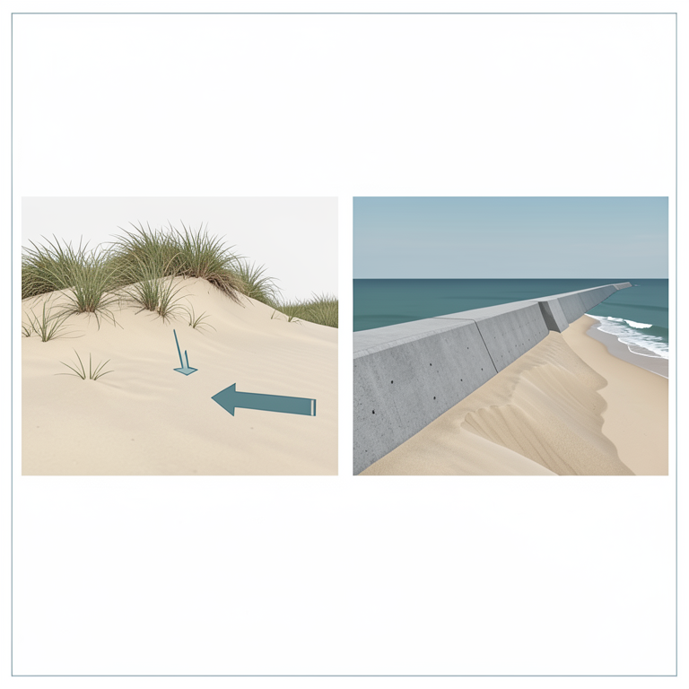
Impact of Seawalls on Dune Retreat
AI-generated conceptual illustration (Coastal sand dunes and a concrete seawall on the Kanthi coastal plain). It explains the idea and does not show study data.
View source evidence ↗Figures & tables
From the original paper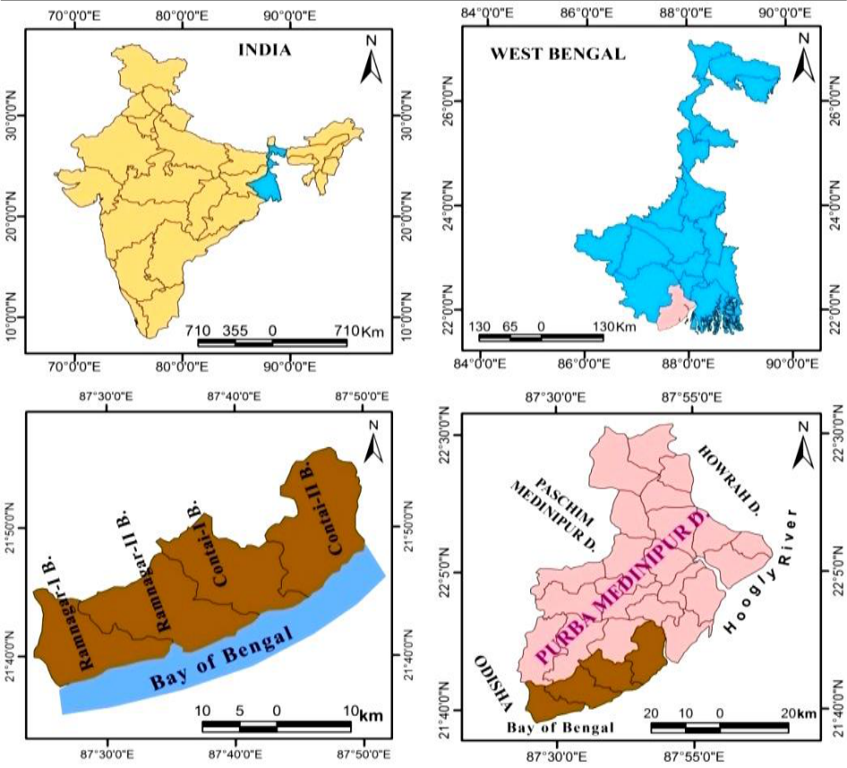 Figure 1
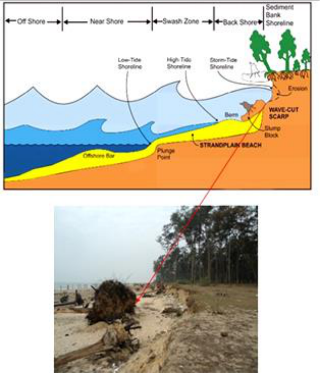 Figure 2
 Table 1
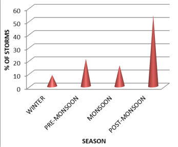 Figure 3
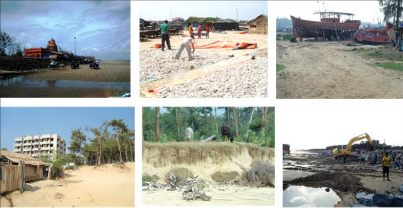 Figure 4
Introduction
The Kanthi Coastal Plain of West Bengal with extensive low lands, wet lands, channel wide estuaries and the giant funnels shape "Bay of estuaries" of Bay Bengal along with wide and shallow of shore provide enough scope for the Effects of disturbance on coastal dune ecosystems. In addition, interactions between various natural processes and anthropocene activities are influence to coastal dune ecosystem. Digha-Junput coastal tract over which this study has concentrated is a part of Kanthi coastal plain of Purba Medinipur, West Bengal (Fig. 1). The extents of the study area is between Latitude-21°36′50 ″ N to 21°43′00″N and Longitude-87°29 ′40″ E to 87°49′ 30″ E. The length from Digha to Junput coastal tract is 45 km and it has 4 blocks are Ramnagar-I, Ramnagar-II, Contai-I, Contai-II. The elevation of the coast in the southernmost region is <3m above the sea level [1,2] . The beach material is generally siliciclastic, quartzo-feldspathic in composition with well sorted, medium to fine sand [3] . The estuarine mud in many places, mixing with the beach sand creates mixed flats. A major portion of the mud is carried to the offshore that constantly keeps the coastal water turbid. The Digha beach, about 8 km long on the west of this coastal stretch, is dominated by sedimentation from the Subarnarekha river, whereas, the eastern-most 6 km long Junput beach gets its major silt contribution from the Hugli estuary [4] . It is ubiquitous that the modern estuary-related beaches have a range of textural gradients and morphologies controlled by fluvial, tidal and wave regime [5,6] . High discharge from the rivers, particularly during the monsoon months in this tropical coast results in deposition near the mouth of the rivers with significant subaqueous growth compared to that of its subaerial counterpart [7,8] . Depending on the present state of erosion-accretion, the entire Digha-Junput stretch is divisible into two parts having contrasting characteristics: (i) Digha to western portion of the Dadanpatrabar sector chiefly under erosional regime and (ii) Eastern portion of Dadanpatrabar to Junput sector belonging chiefly to accretional regime [9] . The geological history of the coast is relatively short and the coast is still in its formative state. Its present day manifestation is the result of fluvio-tidal and coastal processes resulting from the on lapping sequence of Flandrian transgression, > 5900 yrs B.P. and off lapping sequence of delta progradation till the stabilization of the sea level at around 3000 yrs B.P [10,11,9] .
In the present research, we have tried to observe the changes of sand dunes in the physical and anthropogenic activities dimensions of this coastal ecosystem over a period of 4-6 years. For this purpose we have selected some physical components such as i) temperature regime, ii) occurrence of high intensity climatic events like cyclones, iii) tide and current and iv) sea level change. Simultaneously, anthropogenic aspects like construction of sea wall and embankments, pollution of coastal waters, accelerated tourism development, braking, flattening of coastal dunes have been studied to understand the vulnerability of the dunes ecosystem with respect to possible climate change and growth of anthropogenic activities. This present paper focuses on the magnitude of dune disturbance and ecological imbalance in the western 30 km stretch of the beach from Digha to west of Dadanpatrabar under the influence of both natural and manmade activities and has suggested some measures for its restoration and protection.
Materials and Methodology
Materials and Methodology
Results and Discussion
Results and Discussion
Dune Formation with Relation to the Floral Community
In the end of summer and at the end of high tide coastal litter such as the remaining of the dead animals and plants, seeds, parts of the trees are sedimented on the beach. According to [12] the salt tolerant seeds are germinated here and the parts of the trees formed a barrier along the shore. As a result the sand carried by off-shore wind is obstructed by these plants induced barrier and creates low height fragmented sand dunes in many places parallel to the shore. In this way sand dune formation is started which is called incipient dune. After the formation of the incipient dune there are some plants are grow-Sesuvium portulacastrum and Aeluropus lagopoides etc. During high tide the whole area go under water as it is still low. In this way some silt are deposited on the sand dunes. Later the roots of the trees holds the sand like hooks and the leaves of these trees create canopy on the sands and stability is generated and sand dunes with the height of 1-2 m are formulated. Such separated sand dunes are called 'embryo dune'. Now some more new species like Launaea sarmentosa, Ipomoea pescara, Cyprus exaltatus etc. grow here. In this way the sand dune stretches towards the land creates parallel dune row along with the shore line which are called 'fore dune'. These fore dunes are seen at the back of embryo dune and some grass species grow here and make it stronger.
Natural and Anthropogenic Parameters: Impact on dune ecosystem 3.2.1 Tides and Currents
Digha Shankarpur coast is a mesotidal coast highest tidal position is obtained in the month of August the wave energy is a function of the wave heights and the wave periods. It is observed that the near shore zone is influenced by the wave, the long shore drift and also the currents. The beach is under the action of waves, tide, and long shore drift and also in some cases it is shaped by rip currents. The back shore zone is reworked by wind and storm surges or high waves. The result shows accelerated rate of erosion on the beach and unprotected eastern side from hotel Sea Hawk to Digha Mohana (mouth) is severely threatened by coastal dune retreat. In recent time Mandarmoni as an erosional zone because the rise of local sea level, so the frontal dune barrier are eroded by high wave action (Fig. 2).
Frequency of cyclonic storms
Though the tropical cyclone occurs in many parts of the world, the Bay of Bengal is one of the ideal tropical cyclogenesis areas. Meteorological information shows that more than 1000 cyclonic disturbances occurred in the Bay of Bengal during the last century, among which over 500 were either depressions or deep depressions, and over 400 were either cyclonic storms or severe storms. The Bay of Bengal has been affected by a minimum of 3-4 highintensity cyclones every year for the last 20 years (Fig. 3). Severe cyclonic storms over Bay of Bengal registered 26% increase over the last 120 years, intensifying in post monsoon [13] . During the last part of decade (2012-2022) the northern part of Bay of Bengal registered more cyclones viz. Nilam, Phailin, Hudhud, Titli, Fani, Amphan, Yass, Asani etc. From the analysis of cyclone and surge data of the Bay of Bengal, a rise in the high intensity events like severe cyclonic storms has been observed and consequent damage and flooding can be inferred. So, coastal sand dunes are highly influenced by wave attack at the storm tide level in the region. Under storm condition a dune ecosystem can be affected by hydrodynamic forcing in multiple ways. Initially plants and sediment on the fore-dune and sea wave facing dune slope interact with the waves and increased water levels. Besides physiographic changes of fore dune include: dune flattening, wash over dune beaches, dune crest recession, dune erosion on the sea faces, cliff formation and complete elimination of dune bodies (Table 1).
| Location of Dune Belt | Initial Height | Alternation types after storm Damage |
|---|---|---|
| Gangadharpur | 3-9 m | Rapid erosion, Severe scarping, Reduction height, Dune retreat |
| Samybasan | 3-4 m | Dune retreat, Elimination segmentation, Rapid erosion |
| Shankarpur | 3-4 m | Rapid erosion, Severe scarping |
| Chandpur | 2-3 m | Rapid erosion, Severe scarping |
| Dadanpatrabar | 5-8 m | Dune retreat, Elimination of dune bodies. |
Table text extracted from the original PDF; superscript letters are shown inline. The original table image is below.
View original table image
Wind velocity and direction
The landward and seaward movements of dunes are due to high wind speed of pre-monsoon season. It has been observed that the front dune of this area also shifted Landward at the rate of 6 m to 12 m/year. Erosion by over wash might have been dominant between Shankarpur to Chandpur coastal tract, because deposition was made by the landward movement of eroded sand from the dunes.
Rise of sea level
Recently, climate change induced sea level fluctuation is a global phenomenon sea level fluctuation in Bay of Bengal is observed based on Ganges (1985-2000) of Sagar observatory and it has been found that the mean sea level is rising at the rate of 3.14 mm/ year which is significantly higher than the present average global sea level rise 2 mm / year [14] . We collect the sea level data from Diamond harbour, where sea level abruptly rising about 4.7 mm per year. Because the deltaic area basically tectonic zone and also the Ganga-Brahmaputra delta the suspended sediment load is high sedimentation is very high. This implies toe scour and associated crestal slumps of frontal dunes, removal of dune barrier by shoreline recession, reduction of dune height by wind and high wave action, cliffing at the seaward side of dune barrier and flattening of dune field by northward marching are important morphological changes of beach and topography of Kanthi coastal plain at present.
Coastal pollution
The tourist resort with respect to major pollution source is the Digha, Mandarmani region and to a minor degree the Shankarpur area. There are about 400 hotels, holiday homes, some eating joints and sweetmeat shops in Digha. Other tourist areas within the Mandarmani Shankarpur, Tajpur, Junput area etc. Though there is no inventory available the wastes generated from these resources are also directly discharged into the coastal sand dunes waters. Water sample analysis from coastal sea of Digha, Shankarpur area clearly shows considerable amount of biological pollution especially near New Digha and Digha beach. The coliform counts are also significantly high especially in the New Digha and Digha. Beside shipping discharge from major fish centres at Shankarpur, Petuaghat and also from mechanized fishing and cargo boats form some sources of residual oil, grease and solid rejects in addition to material loss during loading and unloading activities are directly impact on coastal ecosystem and also demographic pressure in the urban cities and towns has resulted in the production of enormous amounts of domestic waste materials. These materials reach the marine environment either directly or indirectly through rivers, inlet and dune bodies.
Resistance of dune bodies
The State Government to conserve the neo-dune fields by plantation and with bamboo and wire fencing, human interference in these areas often destroy the whole arrangement. Sand dunes are ideal places for building hotels simply because they offer an open sea view in addition to their better basement stability in the high land areas. So the tops of dunes are generally flattened for building hotels at old Digha and new Digha even the State Government had built a hotel at Digha barely 250 m from the beach front in utter violation of the Act [4] . All these constructions are against the principle of dune-sea dynamics. In other cases, dunes are often breached for easy access to the beach for bathing and recreation. There are cases of such breaching of dunes at Digha, Digha Mohana, Sankarpur and Dadanpatrabar beaches. So the Manmade infrastructure in the coastal region like harbour, road, sand mining, waste disposal site, tourism centre, industrialization, beach resort, fish landing station, demand of fire wood etc. and allied pollution are destroying the sand dune (Fig. 4). Another partial construction of seawall in the Digha sea resort area imparts a negative impact on the adjoining coastal areas. It is observed for the last few years that dunes of the Digha sea beach are fast retreating landward where the seawall has terminated against the unprotected dunes. Measurements show that after the construction of seawall, the rate of retreat of the dunes is as high as 16 m to 18 m per year that was only 11 m per year in 1980s before the construction.
Accelerated tourism development
Though West Bengal has a wide coastline overlooking the Bay of Bengal, The fragmented topographical characteristics followed by inadequate primary infrastructure have been among the deterrents of tourism development in the area. Digha Mandarmani and Shankarpur is the famous picnic spot of West Bengal. Picnicking under the shades of casuarinas trees on the dune surface, walking and bird watching on the sand dunes, bathing in the beaches covered by sea water, car driving and horse riding on the beaches are the major features of recreational exploitation of the coast along this seaside tourist place [15] . Many multi storied hotels have come up within a short distance at the sea wall especially old Digha. Now few hotels are developed on Digha to Mandarmoni coastline. In result the exploitation of coastal sand dunes, coastal ecosystem and vegetation by many human intervations. The indiscriminate installation of heavy tube wells in to the dune bank has led to the collapse of sub-soil layers and the resultant seepage of saline water into the drinking water.
Conclusion
From this research area, it has been observed that the entire terrain coastal tract of Shankarpur, Mandarmani and Dadanpatrabar is under the threat of ecolological imbalance of dune barier. Some natural forcings i.e. storm; tidal waves, flood, sea level rise conditions etc. play jointly and removal of dune barrier, reduction of dune height and flattening of dune field etc. On the other hand Human intervention like harbour, road, sand mining, tourism centre, industrialization, beach resort and fish landing station particularly over the last four decades has also been very significant for the disturbance of dune ecosystem. The authors have some recommendations in favour of protection and conservation of dune bodies the entire coastal tract 1. Construction of semi-permeable fences along the seaward face of dunes will encourage the deposition of windblown sand, reduce trampling and protect existing or transplanted vegetation. 2. Stops the accelerated growth of tourism development and unplanned construction upon the dune bodies. 3. Grow up indegenous grasses and other plants on the front dune which will prevent cyclonic storm and high wave action. 4. A mass awareness programme with a slogan to save the coast is advocated as a measure of conservation strategy.
References
7 in the original paper- Kuehl SA, Moore WS, Levy M, Allison MA. Subaqueous delta of the Ganges-Brahmaputra river system. Marine Geology, Elsevier. 1997;144(1-3):8196.
- Wright LD, Nittrouer CA. Dispersal of river sediments in coastal saes. 1995;18:498-508.
- Chakraborty P. Process-response system analysis in the macrotidal estuarine and mesotidal coastal plain of Eastern India. Memoir of the Geological Society of India. 1990;22(2):165-187.
- Barman NK. Coastal sand dune systems: Location, formation, morphological characteristics analysis through vegetation processes estimation. Journal of Geography, Environment and Earth Science International 2016;4(4):1-8.
- Singh OP. Long-term trends in the frequency of severe cyclones of Bay of Bengal: Observations and simulations. Mausam. 2007;58(1):59-66.
- Hazra S, Ghosh T, Dasgupta R, Sen G. Sea level and associated changes in the Sundarban. J Science and Culture. (Special Issue on Climate Change in India, Ed. Dr. A.P. Mitra.). 2002;68(9-12):309-321.
- Chakraborty SK. Coastal environment of Midnapore (East), West Bengal -Potential, threats and management. Journal of Coastal Environment. 2010;1(1):27-40.