
Research article · 2023 · Full text
International Journal of Geography Geology and EnvironmentSlope stability analysis at soapstone mining sites in Nyamarambe, Kisii County, Kenya
Volume 5(2) · Pages 95–110 · DOI: 10.22271/27067483.2023.v5.i2b.177 ↗
Research areasLandslides and related hazardsTree Root and Stability StudiesGeotechnical Engineering and Analysis
Abstract
Author-writtenSoapstone mining designs cause slope instability, resulting in quarry accidents causing injuries, and death to artisanal miners. Slope destabilization of soapstone strata and sliding of rock masses into open pits are common in soapstone mines. This study assessed the influence of slope angles and heights on the slope gradient, safety factor and instability of the excavated mine slopes. This paper outlines unstable slopes at the mining sites. Studies on soapstone mining in Kisii have mostly focused on socio-economic aspects but very little has been reported on slope instabilities that are common in soapstone rocks mining geosites. Kisii soapstone quarries were examined as several slope failure accidents have been encountered during mining. Field surveys made to the quarries enabled the collection of geomorphometric field data on soapstone quarries and potential slope failure zones. A digital inclinometer and tape measure were used to collect geometric data from the quarries. LEM was used to compute and analyze the factor of safety of slopes to predict the slope instability risks. The findings reveal that unsafe mining designs increase slope angles and heights, inducing instability geohazard risks. The soapstone rock mass in the opencast mines is weak and prone to slope failure. The means of slope angles and heights of the sampled quarries were 69.1° and 6.19 meters with the safety factor mean value of 0.565 indicating that all the examined quarry slopes are unstable. The results reveal that increasing slope angles and heights in soapstone mines decreases the factor of safety resulting in slope failure geohazards. The study recommends that artisanal miners should always mine under optimized slope angles and heights and suggests slope stabilization geotechniques for further scientific and academic research works. This paper provides a significant database for slope failure mitigation, sustainable soapstone mining, post-mining phaseout transformations and management.
Summary
Source-checkedPlain-language reading of the full paper, prepared with AI and checked against the text. Each point links to the authors' own words.
Why it matters
- Poorly designed soapstone mines lead to slope instability, which can cause accidents resulting in injuries or death for artisanal miners. View evidence ↗
- Previous research on soapstone mining in Kisii has primarily addressed socio-economic factors, leaving a gap in knowledge regarding common slope instabilities. View evidence ↗
The question
- The study aimed to evaluate how the height and angle of excavated mine slopes influence their gradient, safety factor, and overall instability. View evidence ↗
What they did
- Researchers used a tape measure and a digital inclinometer to collect geometric data, specifically slope heights and angles, from sampled quarries. View evidence ↗
- The Limit Equilibrium Method (LEM), implemented via Slide 6.0 software, was used to numerically model and compute the safety factor of the slopes. View evidence ↗
What they found
- The sampled quarries had an average slope angle of 69.1° and an average height of 6.19 meters, resulting in a mean safety factor of 0.565, which indicates that all examined slopes are unstable. View evidence ↗
- The Nyabigena quarry was the most unstable with the highest angle (74.8°) and lowest safety factor (0.438), while the Nyagichenche quarry was the least unstable with the lowest angle (61.7°) and highest safety factor (0.676). View evidence ↗
- The average slope gradient percentage was 259.7%; because all sampled quarries exceeded 100% (above 45°), they all showed a high probability of slides and instability. View evidence ↗
- Safety factor values are inversely proportional to slope angles, meaning that as slope angles and heights increase, the safety factor decreases. View evidence ↗
- The presence of joints, cracks, and fissures in the soapstone, combined with weathering, accelerates rock disintegration and weakens the shear strength of the slopes. View evidence ↗
- Water infiltration and stagnation in open pits reduce the frictional resistance and cohesion of the soapstone, contributing to slope instability. View evidence ↗
What it means
- The authors conclude that slope angles and heights must be reduced and optimized, and they recommend avoiding undercutting in favor of a top-down excavation approach. View evidence ↗
- The authors recommend exploring specific geotechniques for stabilization and installing monitoring systems to provide early warning signs of slope failure. View evidence ↗
Visual summary
3 visualsIllustrations explain the paper; charts are replotted from the paper's own table values.
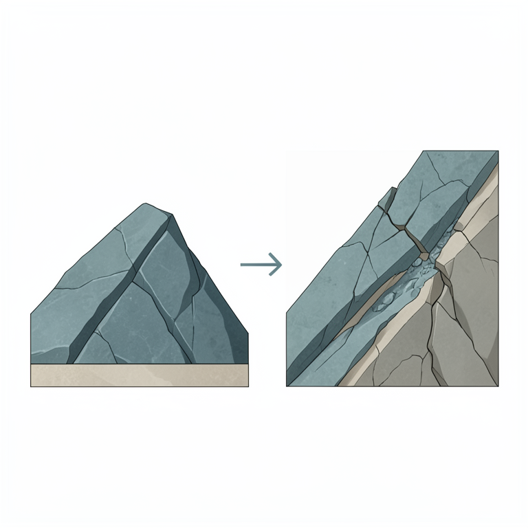
Inverse Relationship of Slope Angle and Safety
AI-generated conceptual illustration (soapstone mine slopes in Nyamarambe, Kenya). It explains the idea and does not show study data.
View source evidence ↗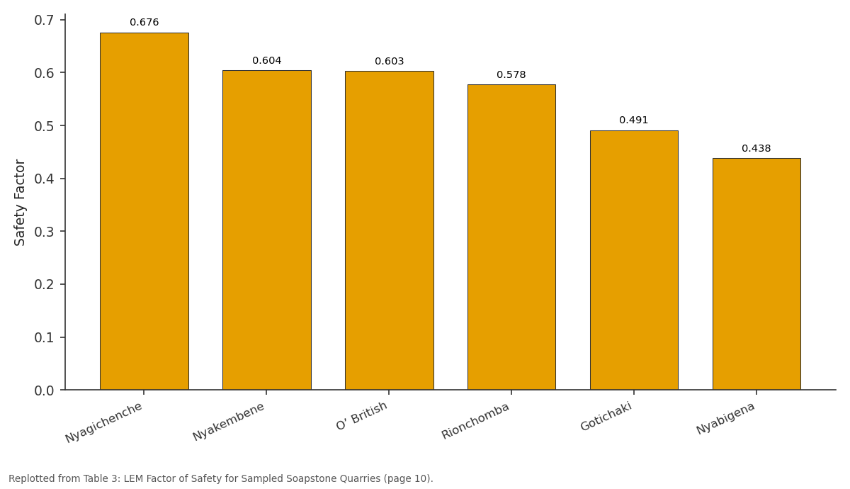
Safety Factor: Nyagichenche vs Nyakembene vs O’ British vs Rionchomba vs Gotichaki
Replotted from Table 3 (page 10) of the original paper. Every bar is the paper's own table value.
View source evidence ↗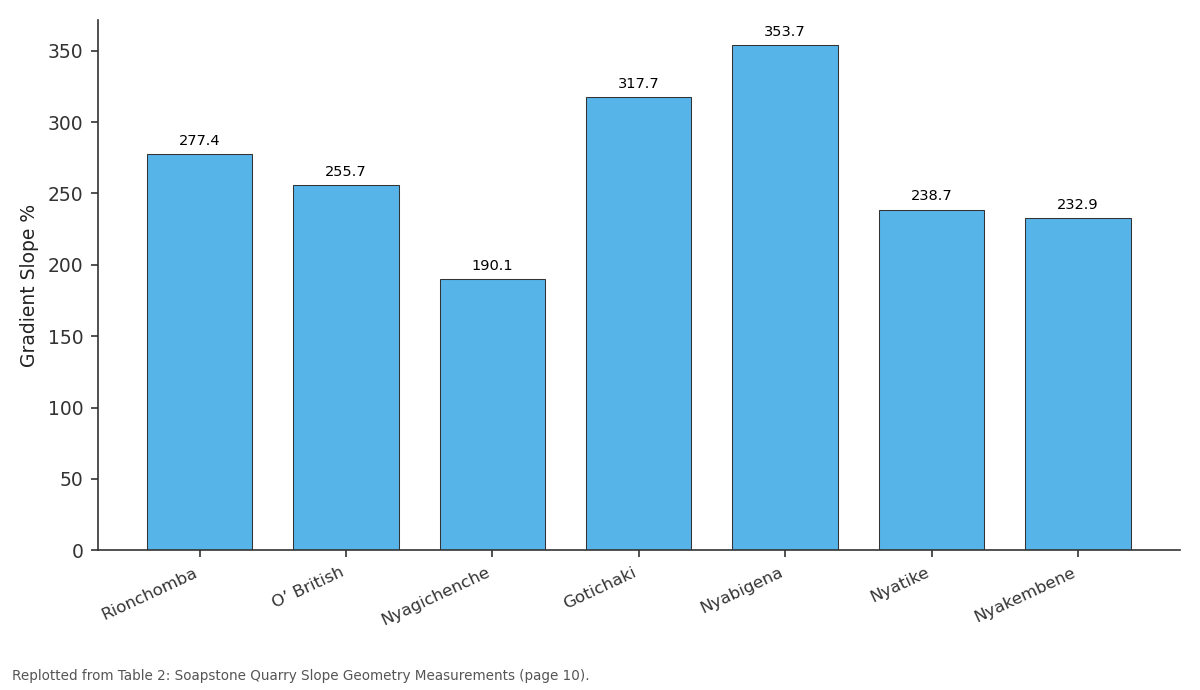
Gradient Slope %: Rionchomba vs O’ British vs Nyagichenche vs Gotichaki vs Nyabigena
Replotted from Table 2 (page 10) of the original paper. Every bar is the paper's own table value.
View source evidence ↗Figures & tables
From the original paper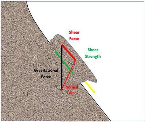 Figure 1
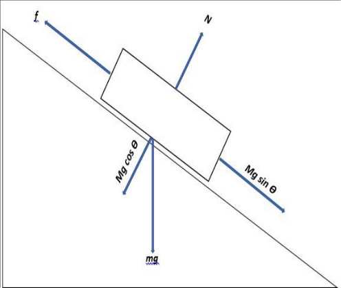 Figure 1
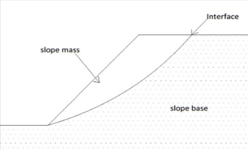 Figure 2
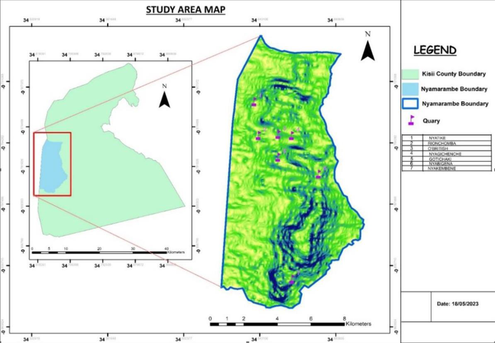 Figure 3
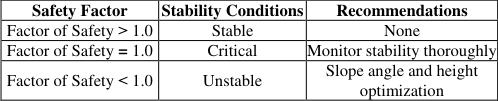 Table 1
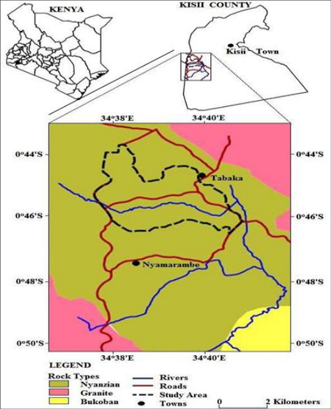 Figure 4
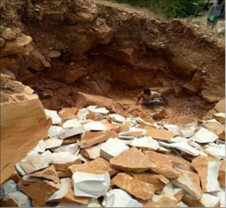 Figure 5
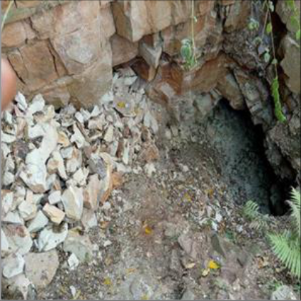 Figure 5
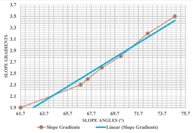 Figure 6
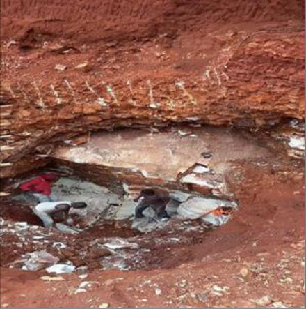 Figure 5
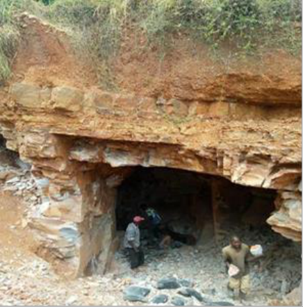 Figure 5
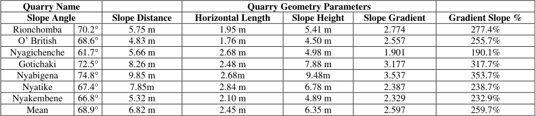 Table 2
 Table 3
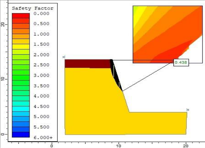 Figure 7
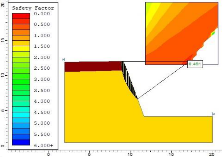 Figure 8
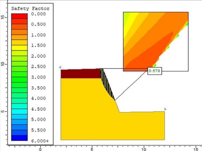 Figure 9
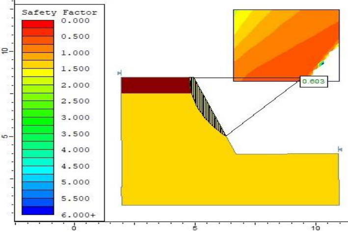 Figure 10
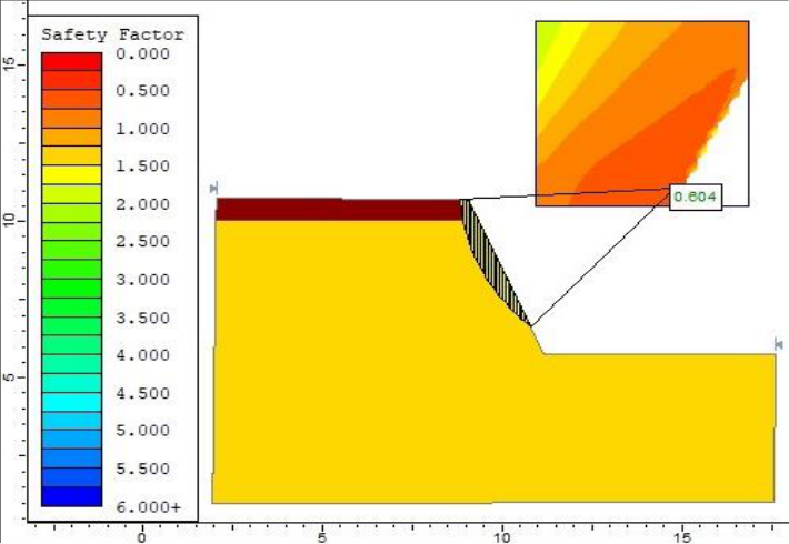 Figure 11
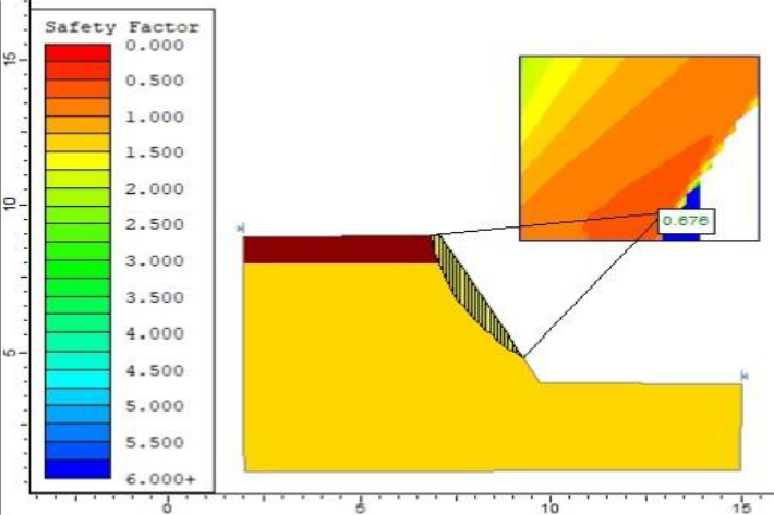 Figure 12
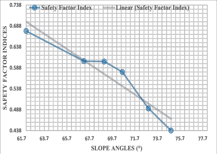 Figure 13
Introduction
A slope is a surface or plane's upward or downward inclination. An earth slope is an unsupported, inclined soil mass surface (Salunkhe et al., 2017) [38] . Slopes are distinct geomorphic structures that can be found not just in mountainous and hilly areas but also in quarries (Atmaja et al., 2019) [4] . A slope is an inclined topography or terrain of the surface of the earth which occurs naturally or is anthropogenically excavated (Abramson et al., 2001) [1] . Slope geometry is deformed and configured by both natural and artificial forces causing instability (Earle et al., 2015) [16] . Slope instability and slope failures are common in many parts of the world. The type and extent of rock structural control which can be split into numerous categories determines how often a rock slope fails (Böhme et al., 2011) [5] . Many rock slope failures exhibit ground movements that indicate escalated velocity trends (Du et al., 2022) [15] . The types of rock slope failures including rotational, translational, toppling, circular and planar collapses are common in quarries (Braathen et al., 2004) [6] . Surface drainage, groundwater conditions, geometry and characteristics of possible slope failures are the main internal factors influencing the stability of the mass of soil and rock slope (Sengani & Allopi, 2022) [39] . Precipitation, seismic activity and human activities are examples of external intervening variables. Human activities such as quarrying make the slopes of mines unstable, hence causing them to collapse (Böhme et al., 2011) [5] .
Globally, the high demand for minerals in the twenty-first century has forced the expansion of mining activities leading to the excavation of minerals in large capacities into deeper levels (Kolapo et al., 2022) [28] . Most minerals that are mined and produced globally do so in open pits using surface mining methods. The opencast method exposes the surface and rocks around the open pit walls to become free to move towards the direction of the face of the slope over a sizable area (Wesseloo & Dight, 2009) [45] . Surface opencast mining is an effective method because it permits high mechanization degrees and large output quantities (Jotham & Mulinya, 2020) [26] . Opencast mining methods majorly depend on the slope gradient and stability of the open quarries, which must not fail throughout the mines' life. Opencast mining operations subject natural slopes to deformation due to reduced shear strength causing rock slope failures (Sutejo & Gofar, 2015) [44] . The mass of rocks and soil in and around the mines develop deformations because of the in-situ stress field characteristics (Stacey & Potvin, 2007) [41] . As a result open pit mines frequently face collapsing and sliding of rock masses which grow more inevitable as the quarrying activities go deeper and get more challenging to control (Kolapo et al., 2022) [28] . In the worst-case scenario, artisanal miners working immediately below unstable quarry slopes may sustain fatalities (Kramadibrata et al., 2012) [29] . Small rockfalls cause fatal injuries to unprotected miners whereas larger landslides harm miners who are confined in larger mining equipment if necessary precautions are not taken (Harries et al., 2009) [24] . According to Clark & Small (2006) [13] , opencast quarrying operations alter the soil profile and bedrock, triggering geomorphic slope movement processes. The loss of vegetation cover due to quarrying activities accelerates weathering, mass movement and erosion on the exposed slopes. Zevgolis et al. (2019) [47] , ascertained that weathering of rocks is slow but constantly accelerates the diminishing of shear strength forces of slope materials. In Africa, Gumisiriza & Lurd (2014) [22] in a study in Uganda probed the role geomorphological slope processes and anthropogenic activities play in the formation of slopes and the causes of slope instability. Thus, the balance of geomorphic slope processes that erode the parent rock while transporting regolith down the slope determines the steepness of a slope. Increased shear stress force of the slope materials causes instability with slope failure being the result (Ciampittiello et al., 2021) [12] . Kenya is rich in mineral resources such as limestone, soda ash, carbon dioxide, diatomite, gold, titanium, silica, gemstones, gypsum, iron ore, fluorite, granite, lead and soapstone. These minerals are mined in various parts of the country including mining of gold in Kakamega and Migori, Titanium in Kwale, Fluorspar in Kerio Valley, limestone in Athi River and Mombasa. In Kisii County, as noted in the annual CIDP, there are two main mineral resources; soapstone and granite (CGK, 2018). The instability of slopes within the quarries is an issue in the quarries of Kisii County. Most mineral production areas are located close to the excavation floor, hence constantly risking the miners and machines used in mining. This sometimes causes loss of lives and property and premature closure of quarries. The Nyamarambe area is characterized by massive soapstone rocks which have been mined since 1885 (GoK, 2016) [19] .
According to Kenya's Department of Geology, the soapstone rock is 25 kilometers long and 265 meters deep. Approximately, 20 percent of the soapstone rocks have been mined (Buyeke & Njoroge, 2015) [9,10] . Dewatering and replanting of vegetation are mostly used to control and manage the instability of slopes in the quarries.
The Slope Concept
The slope of an inclined surface is its resistance to failure due to sliding or collapsing (Salunkhe et al., 2017) [38] . Every type of landform on the earth's surface is a component of some scale of a slope that can be assessed in terms of gradient and length, resulting in a variety of gradients and amplitudes in topography (Njue, 2021) [33] . Slopes can be delineated into two types: natural slopes and artificial slopes. The natural slopes are generated by continual erosion processes and deposition by physical forces. They include hillsides, river embankments, ridges and valley escarpments. Artificial slopes are those that are the product of anthropogenic construction efforts. Among them are embarkments, canals, cut slopes and retaining walls (Palaskar, 2016) [48] . Types of slopes are also categorized as finite or infinite. Finite slopes are slopes of a limited extent while infinite slopes are slopes that represent the border surface of semi-infinite masses of soil, where soil characteristics are constant at all identical depths below the surface (Salunkhe et al., 2017) [38] .
Stability of the Slope
According to research, slope stability is the endurance and shifting capacity of soil covered materials. The stability of a slope refers to the static and dynamic stability equilibrium of earth and rock-fill dam slopes, embankment slopes, engineered slopes, and natural soil and soft rock slopes (Kumar, 2015) [30] . The slope's stability can be calculated using the balance of shear forces and shear strength. Preparation variables may first alter a previously stable slope, making it conditionally unstable (Kumar, 2015) [30] . A slide ensues when a mass of soil beneath a slope fails. It includes the full amount of soil implicated in the collapse flowing downhill and outward. Slope failure is caused mostly by gravity pressures and seepage forces inside the soil (Salunkhe et al., 2017) [38] . They may also fail due to foot excavation or undercutting, or when the soil structure slowly deteriorates. Slides can occur in almost every way imaginable, rapidly or gradually, with or without any visible trigger (Salunkhe et al., 2017) [38] . Climatic events can be triggering factors for slope failures, making slopes actively unstable and hence causing mass motions. Massive movements of slope materials are caused by increasing shear stress, loads, lateral pressure and transient forces (Kumar, 2015) [30] . Weathering, pore water pressure fluctuations and organic material diminish the shear strength of slope materials.
Factors Causing Slope Instabilities
Slope parameters, climatic factors and forces acting on a slope affect its stability. Sliding and collapsing of heaped materials on a slope are influenced by the forces and parameters such as weight, gravity, slope angles and frictional forces acting on a slope as shown in Figure 1. Slope instability is a mass of rock, regolith, debris or unconsolidated soil moving down an inclined plane due to gravitational force. Studies have investigated various geomorphic and human factors responsible for slope instability. Many authors such as Kumar (2015) [30] ; Palaskar (2016) [48] ; Salunkhe et al. (2017) [38] ; Satyanarayana and Sinha (2018) [49] and Suman (2015) [43] , gave special reference to both natural and anthropogenic factors. In a nutshell, they include slope geometric parameters that alter the stability of slopes. The slope geometric parameters including the slope angle, slope height and the total area of the failure surface cause slope instability. The instability of slopes increases with an increase in height and slope angle. The type of rock (Lithology) on open pit slopes determines the strength of rock mass affected by discontinuity, folding, faulting, bedding plane and weathering. Slopes with weathered rocks have weaker shear strength and deteriorate due to seepage of water through them. Geological structures with strata dipping into the excavation and steepening of rock strata affect slope stability hence the slopes become conditionally unstable. Stability is dependent on the shear strength of rock structure orientations. Excess content of groundwater in excavated slopes reduces parameters such as cohesion, adhesive and frictional resistance. This reduces the shearing resistance due to the reduced discontinuity surface friction and effective normal stress. Cohesion is the resistance of slope materials per unit area. It is measured in Pascal (Pa). The lower the cohesion values and frictional condition, the more the slope becomes unstable. Internal frictional angle is a measure of the angle between the normal force and the resistance force. This angle depends on the size and roundness of the particles. The lower the roundness, and the larger the size of the particles, the larger the frictional angle. According to Sailaja et al. (2021) [37] , the instability of opencast mine slopes is significantly affected by the presence of geological disturbances like faults, joints, unconformities and some other man-made mistakes. Surface mining tools and methods in the open pits cause deep cutting and sharply dip the rock strata into the excavation due to greater slope, increasing downward pulling force on the slope, hence causing instability conditions.
A: Steep-Plane B: Steeper Plane Source: Modified from (Earle et al., 2015) [16] C: Steepest Plane D: Sliding Object on a Sloppy Plane With constant gravitational force in models A to C, in model A the force of shear is less than the tensile shear strength forces, and hence the slope is stable thus the block on it is considered stable.
In model B the shear strength and the shear forces are approximately the same thus the slope and the block on it exhibit intermediate stability conditions, implying that its motion may or may not happen hence the need for slope monitoring. In model C the force of shear is greater than the force of shear strength and hence the slope is unstable thus the block is most likely in motion. Shows a rock bedding to the slope hence considered an unstable slope. Model D shows forces and parameters that significantly affect slope stability. Where m is the material's mass, g is the force of gravity, ϴ is the angle of slope, f is the frictional force (mgsinϴ), N is the normal force (mgcosϴ), mg is the weight of materials, sin is the sine and cos is the cosine.
Slope Measurement and Determination of Slope Instability
Slope is a measure of how much the height (elevation) of land changes over a certain distance and time (Burles & Huscroft, 2023) [8] . It is a critical parameter in several wellknown environmental forecasting models. It is the measurement of how much higher an incline or lower a decline is at a specific point of a surface or plane. Slope is measured with an instrument called an inclinometer. When using an inclinometer, the line of measurement is fixed on the target as the slope percentage is read from the scale (DeYoung, 2016) [14] . The inclinometers and tiltmeters are used in surface movement surveying to record changes in the direction and rate of slope movement depth, as well as the aerial extent of the failure mass (Kumar, 2015) [30] . The equilibrium of shear force and shear strength affects the instability of slopes. The slope is conditionally unstable if the shear strength forces available to prevent movement are less than the forces causing the motion. The two basic methodologies used to determine slope instability are limit equilibrium and finite equilibrium (Salunkhe et al., 2017) [38] . Limit equilibrium methods are used to determine the equilibrium of a mass of soil that tends to slide down a slope due to gravitational force as shown in Figure 2. The rotational and transitional motion of slope materials is examined beneath the soil or rock mass on an expected or known probable slip surface. These approaches are particularly crucial in rock slope engineering and the failure of simple blocks along discrete discontinuities. These approaches rely on a comparison of the forces, moments or stresses that oppose the mass movements with those that potentially cause unstable movements. The LEM analysis produces a factor of safety ratio indices, which are described as the shear strength-to-shear stress ratio indices required for slope equilibrium. The slope is conditionally unstable if the safety factor is less than 1. The force opposing movement is divided by the force driving a movement to calculate the safety factor (Salunkhe et al., 2017) [38] . The factor of safety is expressed as 𝐹𝑆 = (𝑆ℎ𝑒𝑎𝑟 𝑠𝑡𝑟𝑒𝑛𝑔𝑡ℎ 𝑎𝑣𝑎𝑖𝑙𝑎𝑏𝑙𝑒) ÷ (𝑆ℎ𝑒𝑎𝑟 𝑠𝑡𝑟𝑒𝑛𝑔𝑡ℎ 𝑚𝑜𝑏𝑖𝑙𝑖𝑧𝑒𝑑).
Source: Modified from (Salunkhe et al., 2017) [38] Fig 2 : Limit Equilibrium Method (LEM)
Slope Movements and Instabilities
The term "slope movement" refers to the outward and downward displacement of slope-forming materials caused by gravity (Gutiérrez & Gutiérrez, 2016) [23] . Rock masse's movements can be lateral or vertical displacements that are triggered by mining activities beneath the steep open pit final slopes (Xu et al., 2016) [46] . Delineation of slope movement and instability processes are often defined by slope failure mechanism, speed of movement and geological materials (Guerra et al., 2017) [20][21] . Combining wellknown geologic, topographic and geomorphic site characteristics with site historical data on previous failures can increase the predictability of a slope failure (Keller, 2017) [27] . The various types of mass movements such as flows, slips, slides and unblock falls, as well as their duration, depend on the slopes, rocks and climatic conditions (Nyaga, 2021) [34] . Any time a slope turns unstable, a mass movement mechanism is triggered and accelerated by climatic, tectonic and human factors. Sometimes a slope is fundamentally unstable during the entire operation, as in the case of soil creep, solifluction and sliding processes, which are continuous (Zevgolis et al., 2019) [47] . The benefit of improved slope failure predictability leads to increased safety at the mining site and valuable resources being saved (Bui et al., 2020) [7] . In the highlands, slope modification and disturbance, which is primarily caused by deforestation linked to population pressure, causes many slope motions such as slope failures and landslides.
A massive slope displacement of the loose topsoil and quarried regolith materials can re-adjust and modify the cultivated quarry slopes to their repose angle. Slope instabilities in the quarrying areas have been greatly impacted by the use of lands with steep slopes with no soil management techniques, as well as engineering projects for building on steep slopes (Bui et al., 2020) [7] . Slope modification by anthropogenic activities or by natural forces can result in the alteration of the slope angle reducing its repose angle. Therefore, it makes sense to associate slope instabilities in such areas with unsafe opencast soapstone mining practices. Gathuru (2012) [18] asserts that soapstone extraction processes also produce molds and boulders made of leftover soapstone ore residual deposits, some of which have incredibly small grains. By liquefying soil colloids, quarrying triggers and accelerates a variety of slope processes and slope instabilities such as slides, rolling, flows, falls, toppling, tension cracks, scree, surficial and massive creeps (Guerra et al., 2017) [20][21] . The likelihood of weathering of exposed soapstone rocks, large-scale slope motions and accelerated soil erosion increases as a result of the mining practices (Londero et al., 2021) [31] . In Kisii County, quarrying sites have unstable zones, and hence unexpected earth movement can cause damages and fatalities. Small rock falls can also cause injuries to artisanal miners who are not protected, while larger and massive landslides during rainfall seasons could harm artisanal miners confined in larger mining operations in the underground opencast pits (Palaskar, 2016) [48] .
Materials and Methods
The Study Area Kisii County is one of the 47 counties of the Republic of Kenya. It is located to the South East of Lake Victoria. The County covers a total area of 1,317.5 km 2 and is geographically located between latitude 0o 40' 38" to 0o 48' 36" South and longitude 34o 34' 46" to 39o 37'41" East. The location of the Nyamarambe division in Kisii is at latitude 0o 45' to 0o 46' South and longitude 34o 36' to 34o 40' East (Buyeke & Njoroge, 2015) [9,10] as shown in Figure 3 below.
Geological Background
The Geological Survey of Kenya carried out the original mapping of the Kisii Series. The Kisii Series is a volcanosedimentary series, laid unevenly on top of the Mesoarchean-Neoarchean, Bukoban, Nyanzian and Kavirondian Series. The so-called "Older Granites" (3100-2850 Ma), which intrude upon the schists and gneisses of the Nyanzian System, are uncomfortably overlain by the systems of bi-modal volcanic rocks and banded ironstone formations 2850-2700 Ma (Meert et al., 2016) [32] . The primary nature of the geological base of the Nyamarambe region consists of talc soapstone, granite, lava quartzite, sandstones and grits. The area is also covered with brown fertile volcanic soils with some areas dominated by stony and rocky outcrops. Metamorphosis of peridotites exposed to heat and pressure at the intersecting points of the plates form the talc soapstone rock (Rumbe, 2021) [36] .
Source: Adopted from Philips (2002)
Methods
The study combined analytical, experimental and descriptive methods. Field surveys and Longitudinal Crosssectional methods were used in this study to collect data. A Composite Research design approach is an integration of qualitative and quantitative surveys in a research study (Asenahabi, 2019) [2] . This research design involved field survey, longitudinal cross-sectional and field experimental measurement data methods. The research used field surveys, experimental measurement and observation tools to collect primary data. A digital inclinometer and tape measure were used to measure and record the slope angles and heights of the sampled soapstone quarry slopes. The assessment involved the observation of proxy physical evidence to delineate potentially unstable slopes, stability conditions of slope surfaces and physical geological features. The safety factor values and slope stability conditions were computed by numerical modeling using compressive Limit Equilibrium Slide 6.0 Version software (Sailaja et al., 2021) [37] .
Data Analysis Method
Slope geometry data was analyzed using Limit Equilibrium Method (LEM) through Mohr Coulomb's (1900) failure equations 1 and 2 (Suhendra et al., 2022) [42] . Numerical modeling by Slide 6.0 Version Limit Equilibrium software and a simple design chart methods were applied to accurately compute and analyze the Factor of Safety, describe and deduce the state of slope stability conditions (Shiferaw, 2021) [40] . This data was analyzed using Bishop's Equation in the LEM numerical modeling Slide 6.0 software. The stability of quarry slopes was examined using a factor of safety that was computed (Shiferaw, 2021) [40] . The strength of the rock mass was shown to be greater than the stress if the computed FoS is greater than 1.0, indicating that the slope is stable. If the safety factor index is equal to 1.0, this demonstrated that the slope has an equal chance of failing or remaining stable. Additionally, if the safety factor is less than 1.0, this demonstrates that the stress exceeds the rock mass's strength and that the slope is therefore unstable (Fleurisson & Cojean, 2014) [17] . The slope stability analysis is a significant factor for planning and designing mining designs of open pits and mines (Prabowo et al., 2023) [35] .
The shear strength (t), effective stress (σn), total stress (σt), porous water pressure (u), cohesion (c), and frictional angle (φ) are the symbols used to denote the above equations. [41] Results and Discussion Figure 5 (A&C) shows a large mass of soapstone rock slanting on the quarry slope face after excessive excavation on the hillside. The geological structure of the soapstone slope face exhibits discontinuities, joints, cracks and fissures exposed to weathering agents which accelerate disintegration of the rock mass resulting in weakening its shear strength. Further, the protruding rock outcrops exfoliate from the main soapstone rock mass as shown in Figure 5 (A).
Slope Gradients and Percentages
The slope gradients of the sampled quarry slopes of soapstone quarries were determined by dividing the slope height (quarry depth) by the horizontal length of the quarry floor. Results in Table 4.2 that show the slope angle and height of open pit quarries are significant factors for the evolution of slope instabilities and slides. The means of slope angles and heights were 68.3° and 6.35 meters, respectively. The means of slope gradients and percentages of the sampled quarries were 2.597 and 259.7%, respectively. their average slope gradient percentage at 259.7%. All the sampled quarries had a slope gradient percentage above 100% (above 45°) showing a high probability of slope instabilities and slides. Figure 6 shows that the slope gradients are directly proportional to slope angles of quarries. This implies that increase in slope angles and heights increase the slope gradients of the sampled quarry slopes. Therefore, the relative slope stability of open pit quarry slopes is significantly influenced by the slope gradients. The quarry slope gradients determine the strength of gravitational force acting on the slope materials.
Slope Stability Analysis of Soapstone Quarry Slopes
The slope stability analysis of the sampled soapstone quarries carried out determined the level of the factor of safety of the mining design angles and heights. The Slide Version 6.0 software was used to perform simulations and models. This facilitated accurate and actual description of the soapstone quarry slopes in the mining geosites. The quarry geometry parameters were tabulated in Table 3. The LEM was used to deduce the factor of safety indices of the sampled quarries. The findings presented in Table 2 above, reveal that the mean slope angles of the sampled six active quarries was 69.1° with 6.19 meters of slope heights. The mean of the factor of safety value was 0.565. The research results also revealed that the Nyabigena quarry had the highest slope angle of 74.8°, and the lowest deduced factor of safety value of 0.438 while the Nyagichenche quarry had the lowest inclined slope angle of 61.7° and the highest factor of safety value of 0.676. The results revealed that increase in slope angles and heights decreased the factor of safety.
| Quarry Name | Quarry Geometry Parameters and Safety Factor | — | — | — |
|---|---|---|---|---|
| Slope Angle | Slope Distance | Slope Height | Safety Factor | |
| Nyagichenche | 61.7° | 5.66 m | 4.98 m | 0.676 |
| Nyakembene | 66.8° | 5.32 m | 4.89 m | 0.604 |
| O’ British | 68.6° | 4.83 m | 4.50 m | 0.603 |
| Rionchomba | 70.2° | 5.75 m | 5.41m | 0.578 |
| Gotichaki | 72.5° | 8.26m | 7.88 m | 0.491 |
| Nyabigena | 74.8° | 9.85 m | 9.48 m | 0.438 |
| Mean | 69.1° | 6.61 m | 6.19 m | 0.565 |
Table text extracted from the original PDF; superscript letters are shown inline. The original table image is below.
View original table image
| Quarry Name | — | — | Quarry Geometry Parameters | — | — | — |
|---|---|---|---|---|---|---|
| Slope Angle | Slope Distance | Horizontal Length | Slope Height | Slope Gradient | Gradient Slope % | |
| Rionchomba | 70.2° | 5.75 m | 1.95 m | 5.41 m | 2.774 | 277.4% |
| O’ British | 68.6° | 4.83 m | 1.76 m | 4.50 m | 2.557 | 255.7% |
| Nyagichenche | 61.7° | 5.66 m | 2.68 m | 4.98 m | 1.901 | 190.1% |
| Gotichaki | 72.5° | 8.26 m | 2.48 m | 7.88 m | 3.177 | 317.7% |
| Nyabigena | 74.8° | 9.85 m | 2.68m | 9.48m | 3.537 | 353.7% |
| Nyatike | 67.4° | 7.85m | 2.84 m | 6.78 m | 2.387 | 238.7% |
| Nyakembene | 66.8° | 5.32 m | 2.10 m | 4.89 m | 2.329 | 232.9% |
| Mean | 68.9° | 6.82 m | 2.45 m | 6.35 m | 2.597 | 259.7% |
Table text extracted from the original PDF; superscript letters are shown inline. The original table image is below.
View original table image
A. 2-D Nyabigena Soapstone Open Pit
In constant internal parameters, the value of the factor of safety (FoS) is 0.438 (unstable) with an overall slope angle of 74.8 degrees a height of 9.48 meters and slope distance (hypotenuse) of 9.85 meters.
The Influence Slope Angles and Heights on Safety Factors
The linear trend in Figure 11 shows that the factor of safety values are inversely proportional to the slope angles of the sampled soapstone quarry slopes. This means that an increase in slope angles and heights reduces the values of the slope safety factor values. The results also revealed that a decrease in slope angle and height increases the values of the slope safety factor. The deduced factor of safety values for the six sampled soapstone quarry slopes are below the slope factor of safety of 1.0. This means that all the six soapstone quarries had unstable slopes which are susceptible to slope failure. Optimization of slope angles and heights indicates that the slope safety factors increase by reducing the slope angles and heights of the soapstone mines. This means that the stability conditions of the slopes can be maintained at their equilibrium by slope optimization analysis. Excavated slopes with greater slope heights require less steep angles to maintain the stability of slopes and safety in mining operations (Atieno & Moses, 2021) [3] .
Discussions
The analysis results indicated that increasing the slope angle decreases the safety factor indices nearly linearly while an increase in height decreases the safety factor indices. Slope angle and height increase decreased the stability of the soapstone mine slopes at a higher rate. Slope gradient and percentage increase increased slope instability and failure. The rock falls and slides were observed in at higher slopes of soapstone outcrops while the soil gapping was observed at heterogeneous layers (loose topsoil of 3m and large mass of soapstone rock beneath) slopes. The slope slide was dominant during rain seasons at different slope angles and slope heights. The impact of increasing slope heights and angles was studied by computing the safety factor simultaneously. The most prevalent slope instability and failure in the current study was slope sliding, collapsing of caves and rock falls. The excavation of soapstone rocks is done by opencast method which results in slopes with higher angles and heights making them highly susceptible to failure. Therefore, it is significant to reduce and optimize the slope angles and heights. Undercutting excavation of soapstone rocks as shown in Figure 5 (I) should be avoided and adapt the top-down approach to slope excavations (Atieno & Moses, 2021) [3] .
Conclusion
Stability of slopes is a fundamental factor in the planning and operation of soapstone open pits and mines. The study identified slope instabilities and delineated them into two namely unstable slopes (Rockfall, rock slides, rock rolling, landslips) and slope failures (Collapse of voids, cavities and caves). The development processes of the steep opencast mining design angles and heights have significantly contributed to slope failures and instabilities in this soapstone rock mass. The safety factor computed from Limit Equilibrium analysis is lower than the critical value of 1 thus the soapstone mine slopes are unstable and hence vulnerable to slope instabilities. The greater the excavated slope angles and heights in the soapstone rock mass, the higher the chances of slope instability. The safety factor of mine slopes had decreased with slope angle and height increase. The type of soil and slope geometry influences slope stability. The type and shape of slope instability affect the sliding mass of soil. Using the slope angle and height optimization techniques for slope stabilization should be thoroughly explored to determine the most appropriate geotechniques and installation of monitoring systems to provide slope failure warning signs to mitigate slope failure accidents at the soapstone mines.
Recommendations
Slope stabilization and optimization of slope angles and heights are recommended to mitigate the effects of slope failure and instabilities. Slope heights and slope angles can be optimized to maximize the factor of safety indices of the excavated mine slopes. This paper, which appears to be the first in Kisii in analyzing and documenting slope stability related to mining of soapstone rocks reveals gaps regarding this database in the county and country.
Acknowledgement
AcknowledgmentSpecial regards to soapstone quarry owners and managing team for granting access to the quarries for a physical study and data collection.
Figures and tables from the paper
| Safety Factor | Stability Conditions | Recommendations |
|---|---|---|
| Factor of Safety ˃ 1.0 | Stable | None |
| Factor of Safety = 1.0 | Critical | Monitor stability thoroughly |
| Factor of Safety ˂ 1.0 | Unstable | Slope angle and height optimization |
Table text extracted from the original PDF; superscript letters are shown inline. The original table image is below.
View original table image
References
29 in the original paper- Asenahabi BM. Basics of Research Design: A Guide to selecting appropriate research design. 6(5), 14. International Journal of Contemporary Applied Researches. 2019;6(5):76-89. (ISSN: 2308-1365) www.ijcar.net
- Atieno J, Moses D. Karst-Induced Geoharzards in Kenya's Coastal Region: A case study of Vipingo coral limestone quarry. European Journal of Environment and Earth Sciences. 2021;2(5):5-17.
- Atmaja RRS, Putra DPE, Setijadji LD. Delineation of groundwater potential zones using remote sensing, GIS, and AHP techniques in Southern Region of Banjarnegara, Central Java, Indonesia. Sixth Geoinformation Science Symposium. 2019;11311:113110O.
- Böhme M, Saintot A, Henderson IHC, Henriksen H, Hermanns RL. Rock slope instabilities in Sogn and Fjordane County, Norway: A detailed structural and geomorphological analysis. Geological Society, London, Special Publications. 2011;351(1):97-111.
- Braathen A, Blikra LH, Berg SS, Karlsen F. Rock-slope failures in Norway; type, geometry, deformation mechanisms and stability. Norwegian Journal of Geology. 2004;84(1):22.
- Bui XN, Nguyen H, Choi Y, Nguyen-Thoi T, Zhou J, Dou J. Prediction of slope failure in open-pit mines using a novel hybrid artificial intelligence model based on decision tree and evolution algorithm. Scientific Reports. 2020;10(1):9939.
- CGoK. Kisii County Integrated Development Plan; c2018-2022. https://repository.kippra.or.ke/handle/123456789/1315
- Ciampittiello M, Saidi H, Dresti C, Coluccino M, Turconi L, Little WW, et al. Landslides along the Lago Maggiore western coast (northern Italy): Intense rainfall as trigger or concomitant cause? Natural Hazards. 2021;107(2):1225-1250.
- Du SG, Saroglou C, Chen Y, Lin H, Yong R. A new approach for evaluation of slope stability in large openpit mines: A case study at the Dexing Copper Mine, China. Environmental Earth Sciences. 2022;81(3):102.
- Fleurisson JA, Cojean R. Error reduction in slope stability assessment. 42 Jayanta Bhattacharya, H. Lieberwirth and Bern Klein. Surface mining methods, technology and systems. 2013;1(41):978-81-909043-88. https://hal-mines-paristech.archives-ouvertes.fr/hal00848689.
- GoK. Kenya mining and minerals policy popular version 2016. Kenya E-Repository; c2016. https://academia-ke.org/library/download/mm-kenyamining-policy-popular-version-2016/
- Harries N, Noon D, Pritchett H, Bates D. Slope stability radar for managing rock fall risks in open cut mines. InRock engineering in difficult conditions, Proceedings of the 3rd Canada-US Rock Mechanics Symposium. 2009;9(15):8.
- Inumula S, Kumar SA. A critical review of stability analysis and design of pit slopes in Indian opencast coal mines. Chemical Engineering Transactions. 2018;66:1231-1236.
- Keller B. Massive rock slope failure in Central Switzerland: History, geologic-geomorphological predisposition, types and triggers, and resulting risks. Landslides. 2017;14(5):1633-1653.
- Kolapo P, Oniyide GO, Said KO, Lawal AI, Onifade M, Munemo P. An overview of slope failure in mining operations. Mining. 2022;2(2):350-384.
- Londero AL, Minella JPG, Schneider FJA, Deuschle D, Menezes D, Evrard O, et al. Quantifying the impact of no-till on runoff in southern Brazil at hillslope and catchment scales. Hydrological Processes. 2021, 35(3).
- Meert JG, Van der Voo R, Patel J. A Neoarchean paleomagnetic pole from the Kisii Series of western Kenya: Implications for crustal mobility. Precambrian Research. 2016;279:91-102.
- Prabowo H, Barlian E, Syah N, Sastra A. Slope stability analysis at coal mining sites in Central Kalimantan. InIOP Conference Series: Earth and Environmental Science. 2023;1173(1):012033.
- Sailaja P, Vignesh A, Fayaz S, Rajesh R. Slope stability analysis of an open pit mine by numerical modelling. 2021;8(7):4. IRJET e-ISSN: 2395-0056 Volume: 08 Issue: 07. www.irjet.net
- Salunkhe MDP, Chvan APG, Bartakke MRN, Kothavale MPR. An overview on methods for slope stability analysis. International Journal of Engineering Research & Technology. 2017;6(03):2278-0181. https://doi.org/10.17577/IJERTV6IS030496
- Sengani F, Allopi D. Numerical study on the evolution process of slope failure triggered by extreme rainfall along a road-cut in mountainous terrain. Scientific Reports. 2022;12(1):6810.
- Shiferaw H. Study on the influence of slope height and angle on the factor of safety and shape of failure of slopes based on strength reduction method of analysis. Beni-Suef University Journal of Basic and Applied Sciences. 2021;10(1):31.
- Suhendra A, Raihan M, Susila IGM. Development of a simple design chart as an evaluation of slope stability. IOP Conference Series: Earth and Environmental Science. 2022;998(1):012020.
- Sutejo Y, Gofar N. Effect of area development on the stability of cut slopes. Procedia Engineering. 2015;125:331-337.
- Wesseloo J, Dight P. Rock mass damage in hard rock open pit mine slopes: Rock mass damage in hard rock open pit mine slopes. 2009 International Symposium on Rock Slope Stability in Open Pit and Civil Engineering, CD ROM, 2009, 7.
- Xu N, Zhang J, Tian H, Mei G, Ge Q. Discrete element modeling of strata and surface movement induced by mining under open-pit final slope. International Journal of Rock Mechanics and Mining Sciences. 2016;88:6176.
- Zevgolis IE, Deliveris AV, Koukouzas NC. Slope failure incidents and other stability concerns in surface lignite mines in Greece. Journal of Sustainable Mining. 2019;18(4):182-197.
- Palaskar SM. Slope Stability Study. www.Ijarse.Com. 2016;5(10):5.
- Satyanarayana I, Sinha AK. A critical review of stability analysis and design of pit slopes in Indian opencast coal mines. Chemical Engineering Transactions. 2018;66:1231-1236.
Cited by 3
From OpenAlex, OpenCitations and reference lists read by Scinovex
- Multiscale Analysis and Preventive Measures for Slope Stability in Open-Pit Mines Using a Multimethod Coupling Approach ↗
Hengyu Chen, Baoliang Wang, Zhongsi Dou · Applied Sciences · 2025
This study investigates slope stability in an open-pit mining area by integrating engineering geological surveys, field investigations, and laboratory rock mechanics tests. A coordinated multimethod analysis was carried out using finite element-based numerical simulations from both two-dimensional and three-dimensional perspectives. The integrated approach revealed deformation patterns across the slopes and established a multiscale analytical framework. The results indicate that the…
❝ 2PDF - Rock Mass Rating (RMR)-Based Slope Stability Assessment and Geological Hazard Characterization at Kaseve Quarry, Machakos County, Kenya (2015-2024) ↗
Charles Ngala Kithome, Julian A. Ogondo, Mary Mwangi · Journal of Geoscience and Environment Protection · 2026
Quarrying in structurally complex crystalline rocks can create significant instability hazards where steep excavation faces intersect persistent discontinuities and seasonal groundwater. This study assessed five representative wall sections at Kaseve Quarry, Machakos County, Kenya, using the Bieniawski Rock Mass Rating (RMR89) system, field structural observations, laboratory-derived strength parameters, historical incident records and SLOPE/W-derived dry- and wet-condition factors of safety (FS).…
❝ 0PDF - Using AI-integrated drones to evaluate blasting impacts on slope stability within open-pit mining operations ↗
Lukman A Alabede · International Journal of Research in Civil Engineering and Technology · 2025
Blasting is a fundamental component of open-pit mining, yet it introduces complex geomechanical disturbances that can significantly influence slope stability. Traditional post-blast assessments relying on visual inspections, ground-based surveying, and point-sensor measurements often fail to capture the full spatial extent, temporal progression, and subtle deformation effects associated with blast-induced stress redistribution. As mines expand in scale and pursue steeper slope