
Research article · 2023 · Full text
International Journal of Geography Geology and EnvironmentDisasters and sustainable development: A case study from Kumaun Himalaya
Volume 5(1) · Pages 183–192 · DOI: 10.22271/27067483.2023.v5.i1b.160 ↗
Research areasDisaster Management and Resilience
Abstract
Author-writtenKumaun Himalaya is geologically very active and sensitive for tectonics and slope instability that reasons a disasters occurrence as a common problem either natural or man-made. This region is highly prone to landslides, earthquakes, cloudbursts, glacial bursts, flash floods and many more man-made activities causing disasters. Disasters are undesirable and sudden events which cause physical, human, economic and environmental losses that exceed the coping capability of the affected community or society. Natural hazards in extreme conditions which can be Metrological, Hydrological, Climatological and Geophysical often cause disasters. Disasters caused due to human actions may either occur in the form of man-made environmental and technological disasters (dam construction, mining, forest fire and pandemics etc.). Uncontrolled forms of man-made disasters may result in desertification and other environmental problems. In such a situation sustainable development is required because it is “Development that meets the needs of the present, without any compromising the ability of future generation to meet their own needs”. Therefore quality of the environmental components has to be checked keeping in mind the concepts of sustainability. This paper discusses the causes and effects of disasters caused by man-made activities and geological sensitivity. The most effective way to address the man-made activities is to adopt sustainable development pathway by modifying the present situation to environmentally sustainable technologies and promotion of energy efficiency, renewable energy, forest conservation, reforestation and water conservation etc. Addressing disasters human requires a good scientific understanding as well as coordinated action at ‘Vocal for Local’.
Summary
Source-checkedPlain-language reading of the full paper, prepared with AI and checked against the text. Each point links to the authors' own words.
Why it matters
- The Kumaun Himalaya region is highly susceptible to disasters due to its geological activity, specifically tectonic sensitivity and slope instability. View evidence ↗
- Disasters in this region are sudden events that cause losses across physical, human, economic, and environmental dimensions, often exceeding the community's ability to cope. View evidence ↗
- Sustainable development is necessary in this context to meet current needs without compromising the ability of future generations to meet theirs. View evidence ↗
What they did
- The research utilized primary and secondary data, including records from the District Disaster Management Office, literature reviews, and the 2011 Census of India. View evidence ↗
- Geographical Information System (GIS) tools were employed to map the disaster-vulnerable areas. View evidence ↗
- The study area encompasses six districts in the Kumaun division: Almora, Bageshwar, Champawat, Nainital, Pithoragarh, and Udham Singh Nagar. View evidence ↗
What they found
- Pithoragarh and Bageshwar are identified as the most vulnerable areas, with Pithoragarh showing a high frequency of earthquakes (8), landslides (3), cloudbursts (2), and flash floods (3) over the last six decades. View evidence ↗
- The 1998 Malpa landslide was a severe event where a lake burst on August 17, followed by a landslide on August 18 that killed over 200 people and wiped out two villages, claiming an additional 43 lives. View evidence ↗
- Unplanned urban development, specifically the expansion of impermeable paved areas, increases flood hazards in low-lying areas by preventing soil absorption of rain. View evidence ↗
- Dam construction is linked to flood and earthquake risks, as structural deficiencies can lead to catastrophic dam failures and uncontrolled water release. View evidence ↗
- The region currently faces an imbalance between environmental health and development due to climate change, glacial melting, and heavy monsoon rains. View evidence ↗
What it means
- The authors conclude that mitigating disaster effects requires scoping exercises involving government departments and active participation from local people. View evidence ↗
- The authors recommend using GIS and GPS for vulnerable area assessment, forecasting, and planning to integrate sustainable development into disaster management. View evidence ↗
Visual summary
2 visualsIllustrations explain the paper; charts are replotted from the paper's own table values.
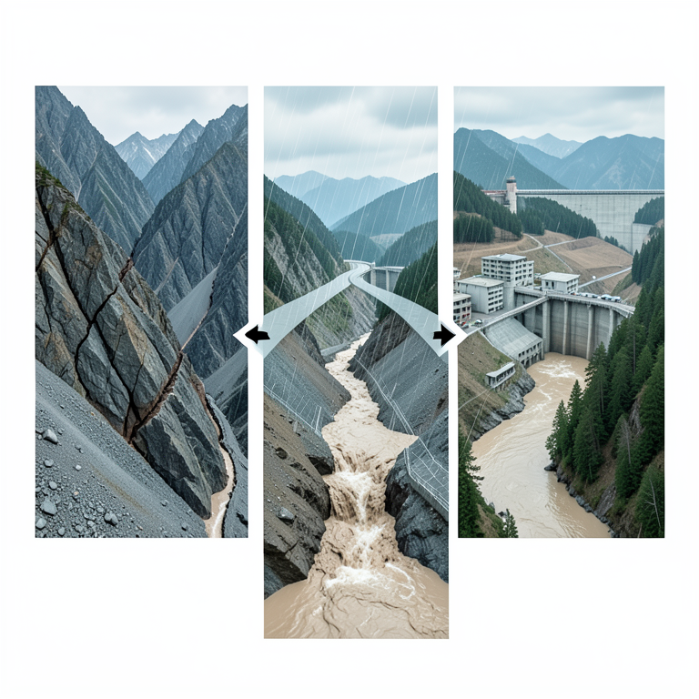
Interplay of Natural and Anthropogenic Disaster Drivers
AI-generated conceptual illustration (Kumaun Himalaya mountain landscape). It explains the idea and does not show study data.
View source evidence ↗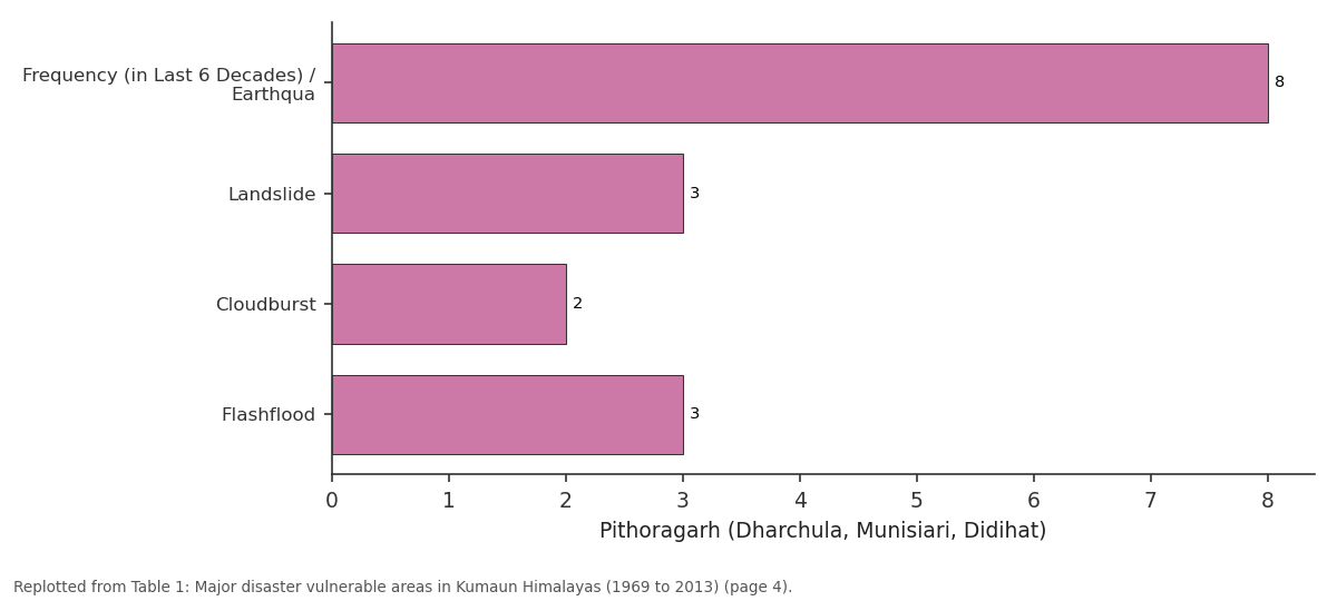
Pithoragarh (Dharchula, Munisiari, Didihat): Frequency (in Last 6... vs Landslide vs Cloudburst vs Flashflood
Replotted from Table 1 (page 4) of the original paper. Every bar is the paper's own table value.
View source evidence ↗Figures & tables
From the original paper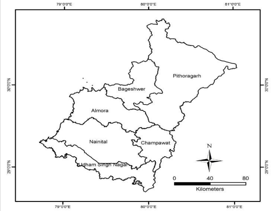 Figure 1
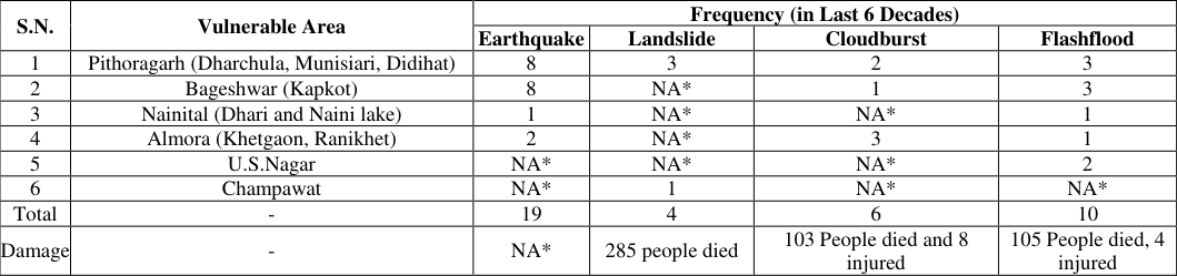 Table 1
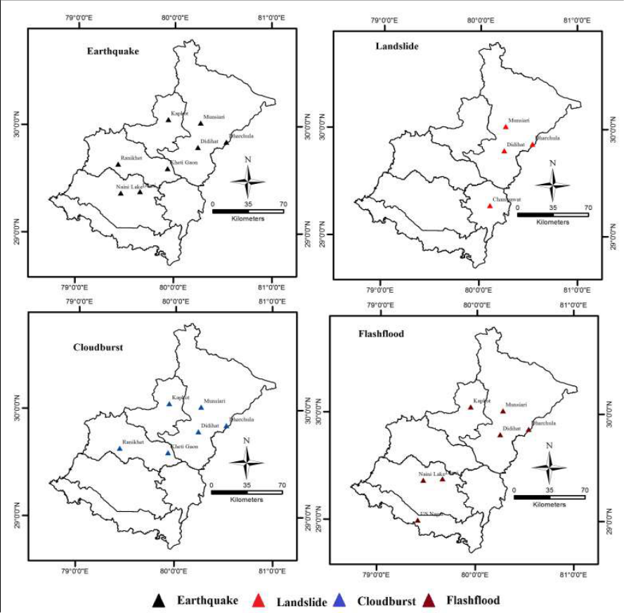 Figure 2
 Table 2
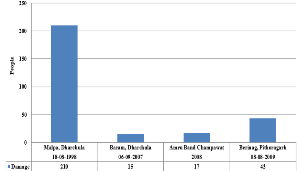 Figure 3
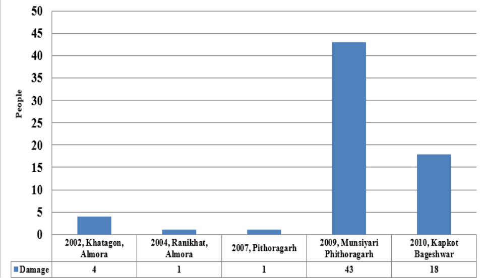 Figure 4
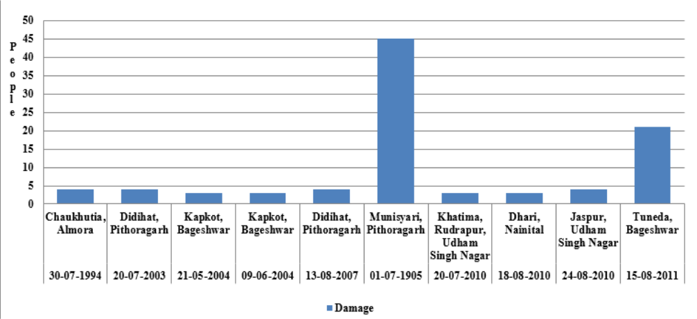 Figure 5
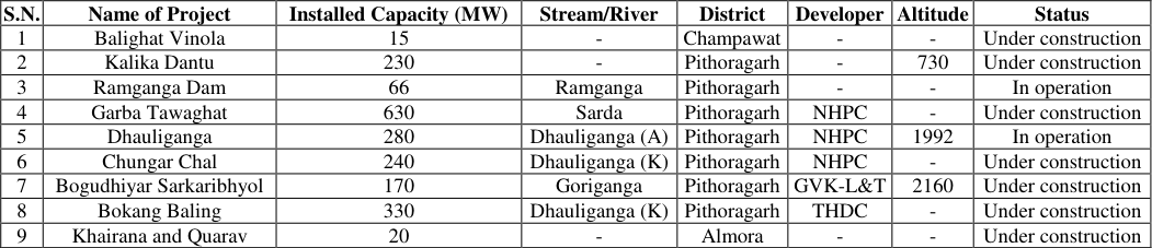 Table 2
 Figure 6
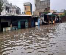 Figure 6
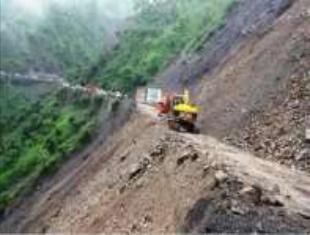 Figure 6
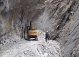 Figure 6
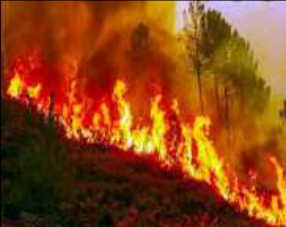 Figure 6
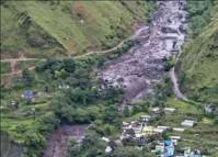 Figure 6
Introduction
Kumaun, an administrative division of Uttarakhand is located in the Indian Himalayan region known for its rich spiritual and religious tourism, ecological richness and diversity and cultural ethos rooted in traditions, but it is also known for growing frequency and intensity of natural disaster and for its fragility of ecological geological systems (NIDM, 2013) [16] . Disaster is an extreme sudden event which mainly occurs due to geological sensitivity and unplanned or mismanaged anthropogenic activities. Disaster is an undesirable occurrence resulting from forces that are largely outside of human control, strike quickly which causes serious disruption of physical landforms or phenomena as well as life and property include death and injury to a large number of people (Ashok Kumar, 2016) [23] . The disaster can be broadly divided into two parts based on the causes of disaster which are natural disasters and anthropogenic disasters (Jha, 2010) [7] . It appears on earth surface in the form of extreme events both natural and man induced, which cause serve damage to human life on one hand and other biological communities on the other hand. Such sudden catastrophic events are the result of natural and human factors; for example volcanic eruption, earthquake and tsunami are exclusively caused by natural processes but landslide, flood, fire and nuclear disaster. In the 20 year period between 2000 and 2019, EM-DAT recorded 7,348 disasters events, which claimed a total of approximately 1.2 million lives and affected more than 4.03 billion people. On average, there were 367 disaster events each year, the majority of which were floods and storms (44% and 28% respectively). The economic loss due to disasters during this period was US $ 2,97,000 crore (UNDRR, 2019) [26] . The disaster events are the most common phenomena of Kumaun Himalayas, Uttarakhand. According to the Bureau (UNDP, 2016) [24] of Indian Standards, on a scale ranging from I to V in order of increasing susceptibility to earthquakes, study area lies inside seismic zone VI and V.
Study of geomorphology and geology are very useful aspects for disaster mitigation, Remote Sensing (R.S) and Geographic Information Science (G.I.S) are very helpful techniques for disaster management and identification of disaster-prone areas (Ahmad and Goparaju, 2018) [1] and sustainable development. The advance knowledge of disasters, new techniques of reduction are developed in many countries but the frequency and intensity of disaster remain constant (Gardner, 2002, Van Aalst and Burton, 2002) [4] . In present, forest fire and landslide are very frequent events in the form of man induced disaster and earthquake, erratic heavy rainfall, cloudburst, flood and flash flood events are occurred frequently during before and after monsoon season are commonly observed as natural hazards often resulting in disasters. Consequently effect of these disasters, damage to plants, the habitats of humans and wild animals, agricultural land and construction sites as roads, bridge and other infrastructures are devastating. The disaster events affect the development process of the entire Kumaun Himalaya region and the life inhabitants live in the hilly areas. It is not possible to stop the occurrence of disasters but human the damage caused can be reduced by disaster by sustainable development.
In the recent years extreme rainfall events have become common and recurring phenomenon in the Himalaya, especially in Garhwal and Kumaon regions of Uttarakhand. In the year 1998 the state witnessed major landslides at Malpa, Pithoragarh and Okhimath, that took toll of more than 350 human lives (Rautela P, Paul SK, 2001) [20] . In the year 2010 Uttarakhand experienced unusually heavy rainfall between 16 and 20 September that resulted in a number of landslide, cloudburst and flash flood events throughout the state. Around 9,162 villages and many towns with population of 29.23 lakh were affected by these incidences that took toll of 214 human lives. More than 26,011 residential houses were damaged while around 1,771 farm animals were lost (Sharma S., 2012) [21] . Development in the mountains, therefore, has to have a different approach, given the fragility and vulnerability of the Himalayan ecosystems due to the uniqueness of mountain specificities (Jodha NS, 1992) [11] .
Objectives
The present study mainly focuses on disaster and Sustainable Development. The main thrust of this study discusses disasters and their types and how sustainable development correlates disasters with occurrences planning and management. The following objectives are presented in this paper: 1. To study the disasters and their types in Kumaun Himalaya. 2. To identify disaster vulnerable areas. 3. To study the causes due to man-made activities. 4. Identify the important role of sustainable development in disaster management.
Methodology
The present study is completed with the help of primary and secondary data collection. India has the highest mountain chain on earth, the Himalayas, which are formed due to collision of Indian and Eurasian plate, the northward movement of the Indian plate towards China causes continuous stress on the rocks making them friable, weak and prone to landslides and earthquakes. The slow motion of the Indian crust, about 5 cm/year accumulates stress to which natural disasters are attributed. Some landslides make unique, and unparalleled catastrophes. Geographical area of the state is 53,483 square kilometers; 93% of which is mountainous and 64% is covered by Forest (Khanduri, 2020) [28] . Geologically, this region is a young mountainous terrain and this region is
Results and Discussion
Kumaun Himalaya is geologically very sensitive and prone to man induced disaster events. The study area faces several disaster occurrence such as earthquakes, landslides, heavy rains, flood and flash floods, cloudbursts and forest fires due to uneven relief, mountains region, slope instability, erratic heavy rainfall, flash flood and their interrelationship with human activities. Extreme disasters events strike the study area occur most during the monsoon season (July to September) and forest fires in the summer season (March to June) apart from this cloudbursts and earthquakes may occur at any month or anytime throughout the year. This research paper focuses upon the major sensitive areas where disasters frequently were high.
Disasters vulnerable areas in Kumaun Himalaya region
Natural and man induced disasters in Uttarakhand are define due to its tectonic activity, lithological, structural and ecological setting, topography and changing landscapes owing to various natural and anthropogenic activities. Natural disasters like earthquakes, landslides, slope failers, rock falls, avalanches, cloudbursts, hailstorms, Glacial lake outburst floods (GLOF), floods, flash flood, lightning, forest fires etc. are frequent in Uttarakhand causing loss of life and property from time to time (NIDM, 2013) [16] . The disaster events are the most common phenomena of Kumaun 2) are the most vulnerable areas out of these disaster affected areas of Kumaun Himalaya, which show the highest frequency of disaster (Table 2). Various geomorphic processes including pluvial, fluvial, mass wasting and anthropogenic processes are degrading the basins in this fragile area, (Joshi, 2016) [9] . These active processes result into disasters several times in the basin area.
| S.N. | Name of Project | Installed Capacity (MW) | Stream/River | District | Developer | Altitude | Status |
|---|---|---|---|---|---|---|---|
| 1 | Balighat Vinola | 15 | - | Champawat | - | - | Under construction |
| 2 | Kalika Dantu | 230 | - | Pithoragarh | - | 730 | Under construction |
| 3 | Ramganga Dam | 66 | Ramganga | Pithoragarh | - | - | In operation |
| 4 | Garba Tawaghat | 630 | Sarda | Pithoragarh | NHPC | - | Under construction |
| 5 | Dhauliganga | 280 | Dhauliganga (A) | Pithoragarh | NHPC | 1992 | In operation |
| 6 | Chungar Chal | 240 | Dhauliganga (K) | Pithoragarh | NHPC | - | Under construction |
| 7 | Bogudhiyar Sarkaribhyol | 170 | Goriganga | Pithoragarh | GVK-L&T | 2160 | Under construction |
| 8 | Bokang Baling | 330 | Dhauliganga (K) | Pithoragarh | THDC | - | Under construction |
| 9 | Khairana and Quarav | 20 | - | Almora | - | - | Under construction |
Table text extracted from the original PDF; superscript letters are shown inline. The original table image is below.
View original table image
| S.N. | Disaster | Earthquake | Landslide | Flash flood | Flood |
|---|---|---|---|---|---|
| 1 | Almora | H | H | H | L |
| 2 | Bageshwar | VH | VH | VH | L |
| 3 | Chapawat | H | H | L | VH |
| 4 | Nainital | H | VH | H | VH |
| 5 | Pithoragarh | VH | VH | VH | L |
| 6 | Udham Singh Nagar | H | L | L | VH |
Table text extracted from the original PDF; superscript letters are shown inline. The original table image is below.
View original table image
Past Disasters in Kumaun Himalaya
During this period (1980-1999), 4,212 disasters killed about 11.9 lakh people, affected 300 crore people and caused an economic loss of US $ 1,63,000 crore (UNDRR, 2019) [26] . Better reporting and recording can be considered responsible for this increase in disaster incidents to some extent, but mainly the increase in weather related disaster incidents is responsible for this. Environmental Hazards and disasters are normally divided into the following two broad categories on the basis of main causative factors and their mode of origin (Singh S. and Singh J., 2014, pp.5) [25] : (i) Natural Hazards and Disasters (ii) Man induced (anthropogenic) hazards and disasters. From the causal point of view of disaster, natural disaster is the most influential factor in Kumaun Himalaya region, mainly due to origin of Himalayas and its tectonic activity. Naturally, it is a mountainous region in which slope stability, sensitivity of rocks and human interference are the main factors. It is true that geographical and meteorological conditions are mainly responsible for the occurrence of frequent disasters resulting huge loss of life and property, it cannot be denied that the factors like inadequacy of warning communication systems, lack of preparedness and workable disaster management plans (CEE, 2004) [27] . At present, the exploitation of nature is increasing due to the greed of human beings due to which the challenges of the victory (Possibilism) of man over nature is proving to be true. Therefore out of natural and man induced disasters, man induced disaster proves to be the most destructive, whose effect also remains on natural disaster. The major disasters in Kumaun Himalaya since 1969 to 2013 are described as follows.
It is clear from 1) have occurred. Geological structure and human activities are the main causes for an increase in the disaster vulnerable areas. Earthquake hazard potential is assessed to be particularly high in the entire Himalayan terrain and in the past the region has been joined by four great earthquakes, apart from Kumaun Earthquake of 1720 and Garhwal Earthquake of 1803 (NIDM, 2019) [26] . It is clear from the above Table 1 that the entire Kumaun Himalaya has been affected in past landslides. The Malpa landslide of 1998 is considered one of the most severe landslide disasters in recent times. Due to which not only the local people but also at the national and international level were affected (Fig. 3). Some events of tragedies are reported as landslide in Kumaun Himalaya, 1998 Malpa in Pithroagarh, 2009 Berinag-Munsiyari road, Pithoragarh as well as 2008 Amru Band in Champawat. The landslide wiped out two villages namely Jhakhla and Lah claiming 43 lives in Pithoragarh. The lake burst in the night of 17 August 1998 released a huge amount of water together with boulders and debris. On 18 August 1998, the inevitable happened and the huge landslide overran the Malpa habitation and took toll of more than 200 people besides blocking the stream yet again. Bursting of the landslide dam this time washed off the dead bodies and severely hampered the pace of the rescue work (Paul et al., 2000) [20] . Flash food is a differently damage life and property and is most visible in the southern part (southern Nainital and Udham Singh Nagar) of Kumaun Himalayas of Uttarakhand. It is clear from the disasters of past that it has been effective not only on the southern districts but also rather the areas including parts of Pithoragarh and Bageshwar in the northern part of the study area (Fig. 5). If studied in the context of flood the flood of 2011, Tuneda Bageshwar was very effective which caused maximum damage.
| S.N. | Vulnerable Area | Frequency (in Last 6 Decades) | — | — | — |
|---|---|---|---|---|---|
| Earthquake | Landslide | Cloudburst | Flashflood | ||
| 1 | Pithoragarh (Dharchula, Munisiari, Didihat) | 8 | 3 | 2 | 3 |
| 2 | Bageshwar (Kapkot) | 8 | NA* | 1 | 3 |
| 3 | Nainital (Dhari and Naini lake) | 1 | NA* | NA* | 1 |
| 4 | Almora (Khetgaon, Ranikhet) | 2 | NA* | 3 | 1 |
| 5 | U.S.Nagar | NA* | NA* | NA* | 2 |
| 6 | Champawat | NA* | 1 | NA* | NA* |
| Total | - | 19 | 4 | 6 | 10 |
| Damage | - | NA* | 285 people died | 103 People died and 8 injured | 105 People died, 4 injured |
Table text extracted from the original PDF; superscript letters are shown inline. The original table image is below.
View original table image
Man induced disasters in Kumaun Himalaya
Man induced disasters also known as anthropogenic disasters, are defined as activities of humans, whether deliberate or indeliberate, leading to great loss of human lives, economic and physical environment. Events that are caused by humans and their activities and occur in or close to human settlements are termed as anthropogenic disasters. Kumaun Himalaya being a mountainous region becomes important from the point of view of disaster because it falls under very sensitive zone from geological and tectonic point of view due to which landslides; earthquakes, flash floods and natural and man-made forest fire are common disasters. Intentional or unintentional all kind of man-made disasters lead to human sufferings loss of life and long term damage in economy. Some of the human activities also accelerate and motivate natural disasters such as dam failure floods, reservoir-induced seismic events, landslides (deforestation and road construction), accelerated soil erosion (caused by faulty farming practices and deforestation) etc. Human induced disaster could arise from the unintentional activity as poor maintenance, low quality work or human error, or from intentional activity likes sabotage, mischief, revenge, riots, mob fury, enemy attack etc. Sometimes, man-made disasters are the results of system or process malfunctioning as in the case of nuclear radiation, gas leak, explosion and fire. System failures or accidents occur due to technical malfunction or human error.
Main Causes of Man-made Disasters
Kumaun Himalaya's geography and geology is very dynamic as vast and maximum of the area is mountainous region. Deforestation, land grazing, legal and illegal development on the soft bed of rock leads to disasters when earthquake, landslide and flash flood hit the area. It is clear from the felid inventory of the study area that while tampering with the Himalayan slopes, one need to be extra careful as these are the slopes, which have evolved by earth exogenic and endogenic processes and hence are dangerously balanced, which makes them more vulnerable to disasters (Nair AS and Singh SK, 2014) [16] . India has the highest mountain chain on earth, the Himalayas, which are formed due to collision of Indian and Eurasian plate, the northward movement of the Indian plate towards China causes continuous stress on the rocks rendering them friable, weak and prone to landslides and earthquakes. The slow motion of the Indian crust, about 5 cm/year accumulates stress to which natural disasters are attributed. Some landslides make unique and unparalleled catastrophes. Cause of man-induced Disasters are. i) Unplanned cities: Urban development can change the environment or ecosystem through, for instance, the expansion of paved, impermeable areas, which prevent rain from being absorbed by the soil thereby increasing flood hazard, particularly in low-lying areas. Most of the effects of the disasters are seen in the urban areas because the population density is high rather than rural areas. The main reason of disasters in these areas because of excessive development and infrastructures construction are high rather than rural areas.
Inadequately planned and managed cities also create new risks which threaten to erode current development gains (Fig. 6.a). The lack of adequate infrastructure and services, unsafe housing, inadequate and poor health services can turn natural hazard into a disaster. In 1993, several buildings collapsed in south western part of Almora town (Joshi and Pushpa, 2019) [10] .
ii) Lack of proper drainage system: Flash flood is a main disaster which is influence local people. Due to which town and road networks drainage system are overflow in during heavy rainfall. Its resulting in even a small drain would attract the huge block water on the roads which would travel the people by walking, vehicle and everything (Fig. 6.b). Natural drainage in and around Almora town area has blocked the natural drainage system in western part of city (Joshi and Pushpa, 2019) [10] .
Conclusion
This research work through extensive field study identifies disaster and the vulnerable areas within Kumaun Himalayan region and developments keeping in mind the past disasters and their consequences. In present Kumaun Himalayas are suffering from different disaster events and situations such as climate change, glacial melting, pre-monsoon and during monsoon heavy rains due to which an imbalance between environment and sustainable development strategies. The maximum population of Kumaun Himalayas remains highly affected because where on one side disaster is showing its wrath on the other side they have no sources of job and infrastructure. Most of the Kumaun Himalayas districts are included in vulnerable areas as frequency and intensity of enormous extreme events is unpredictable and dangerous all over the entire region. Natural factors are the major cause of disasters in Kumaun Himalaya but no doubt human activities are equally responsible in triggering these events. Prevention is necessary to have disaster management and sustainable development. Thus, determining vulnerable area assessment, forecasting, estimation, mapping, planning, strategies and management of the potential related with different disasters and assistance of sustainable development with the help of GIS and GPS is required. Therefore develop scoping exercise with the involvement of different government department that should not only be responsible for it but ensure active participation of the people at the local level is also necessary to mitigate the adverse effect of disasters.
Figures and tables from the paper
References
20 in the original paper- Ahmad F, Goparaju L. Climate change and its impact on forest fire in the state of Himachal Pradesh and Uttarakhand states of India: Remote sensing and GIS analysis, Contemp. Trends Geoscience. 2018;7(2):229246.
- Alaknanda Valley. Indian Himalayan region. Journal of Mountain Science. 2004;3(3):228-236.
- Gardner J. Natural Hazards Risk in the Kullu District, Himanchal Pradesh, India in the Geographical Review. 2002;92(2):282-306.
- Jha MK. Natural and anthropogenic disaster: An overview, Springer, 2010, 1-16.
- Joshi V, Kumar K. Extreme rainfall events and associated natural hazards in Alaknanda valley. Indian Himalayan region. Journal of Mountain Science. 2006;3(3):228-236.
- Joshi J. Tectonic Processes and Landforms in the Lesser Himalayas: An experimental study from Khairna Watershed. National Geographical Journal of India. 2016;62(4):303-314.
- Puspa JJ. Urbanization, drainage systems and sustainable development: An experimental study from Almora town. Journal of Sustainable Urban Development. 2019;1(1):303-312.
- Mehta M, Zahid M, Dobhal DP, Srivastava P. Geomorphological evidences of post -LGM glacial advancements in the Himalaya: A study from Chorabari Glacier, Garhwal Himalaya, India. Journal of Earth System Science. 2012;121(1):149-163.
- Nair AS, Singh SK. 'Understanding The Causes of Uttarakhand Disaster of June 2013: A Scientific Review,' AP Pradeepkumar, FJ Behr, FT Illiyas and E Shaji 2014 Proc. 2nd Disaster, Risk and Vulnerability Conference 2014 (DRVC2014) 24-26 April 2014 Dept of Geology, Uni Kerala, Trivandrum, India; c2014. p. 57-64.
- Nair AS. Causes of Uttarakhand Disaster June 2013, Int ernship Report, NIDM, New Delhi; c2013. p. 20.
- Paul SK, Bartarya SK, Rautela P, Mahajan AK. Catastrophic mass movement of 1998 monsoons at Malpa in Kali Valley, Kumaun Himalaya (India). Geomorphology. 2000;35(3-4):169-180.
- SEOC Data. State Emergency Operation Centre, Disaster Management and Mitigation Centre, Govt. of Uttarakhand. Uttarakhand Data received from SEOC, Dehradun on 3 December 2013 through Emoi; c2011.
- Rautel P, Thakur V. Landslide hazard zonation in Kaliganga and Madhyamaheshwar valleys of Garhwal Himalaya: A GIS based approach. Himalayan Geology. 1999;20(2):31-44.
- Rautela P, Paul SK. August, 1998 landslide tragedies of Central Himalayas (India): learning from experience. International Journal of Environmental Studies. 2001;58(3):343-55.
- Sharma S. Catastrophic hydrological event of 18 and 19 September 2010 in Uttarakhand, Indian Central Himalaya: An analysis of rainfall and slope failure. Current Science; c2012. p. 327-332.
- Kumar A, Dhar K, Kanwar SS, Arora PK. Lipase catalysis in organic solvents: advantages and applications. Biological Procedures Online. 2016;18:111.
- UNDP A. Africa human development report 2016 accelerating gender equality and women's empowerment in Africa. United Nations Development Programme (UNDP); c2016.
- Singh SR. Public health spending and population health: A systematic review. American Journal of Preventive Medicine. 2014;47(5):634-640.
- Gorton M, Davidova S. Farm productivity and efficiency in the CEE applicant countries: A synthesis of results. Agricultural Economics. 2004;30(1):1-6.
- Khanduri S. Cloudbursts over Indian sub-continent of Uttarakhand Himalaya: A traditional habitation input from Bansoli, District-Chamoli, India. International Journal of Earth Sciences Knowledge and Applications. 2020 Jul 31;2(2):48-63.
Cited by 12
From OpenAlex, OpenCitations and reference lists read by Scinovex
- A comprehensive review of the performance of pine needle geotextiles in reinforced subgrade pavement for sustainable road construction and maintenance ↗
Vimal Mohan, Abhishek Nandan · Environmental Science and Pollution Research · 2025
❝ 8 - Impact of Major Road Network on Landscape and Growth Pattern in Tehri Region: A Geospatial Technique ↗
Akhilesh Nautiyal, Anurag Gunsola, Samarth Y. Bhatia · Land Degradation and Development · 2025
ABSTRACT This study examines land use and land cover (LULC) changes in the Tehri region from 2000 to 2024, utilizing the Shannon Entropy Index (H) as an indicator of sustainable urban growth by analyzing spatial dispersion patterns of built‐up areas. Landsat imagery from 2000, 2010, 2020, and 2024 was classified into barren land, built‐up areas, forest areas, and water bodies…
❝ 5 - GeoRisk Intelligence: Hybrid Ensemble Data-Driven Models with Recursive Feature Elimination for Landslide Susceptibility and Infrastructure Vulnerability in Uttarakhand ↗
Alireza Habibi Khouzani, Chiranjit Singha, Armin Moghimi, M. R. Delavar · Earth Systems and Environment · 2025
❝ 3 - Building resilience: Safeguarding Odisha from natural calamities ↗
Arta Barik, Keshab Chandra Ratha · International Journal of Political Science and Governance · 2024
Due to its geographical location and socioeconomic circumstances, Odisha, an eastern state in India, is susceptible to several natural disasters, including earthquakes, floods, and cyclones. The present study examines strategies to protect Odisha from such calamities, considering the state's susceptibility and the imperative nature of preventive measures. Initially, it assesses the susceptibility of Odisha to natural calamities by analysing the
- Teacher’s Role in Enhancing Students’ Environmental Literacy: A Systematic Literature Review 2019-2024 ↗
Dwi Larasaty, Dede Rohmat, Lili Somantri, Almala Nur Fitriana · Jurnal Pendidikan MIPA · 2024
Environmental issues are often heard, but there are many people who do not have awareness of these issues. Environmental ethics in everyday life are sometimes overlooked. People still need to understand how environmental bad habits will have a negative impact in the future. To have environmental awareness, environmental literacy is required. Environmental literacy can be obtained through formal and non-formal…
❝ 2PDF - Comparative Assessment of Land Stability Analysis of Towns of the Kumaun Himalaya, Uttarakhand ↗
Alimpika Gogoi, Girish Ch Kothyari, Atul Kumar Patidar · Geological Journal · 2026
ABSTRACT The rapid urbanization across the Kumaun Himalaya has made it gradually necessary to evaluate land stability, as unstable land can significantly increase the risks of disasters. The present study conducts a comparative analysis of the three rapidly growing towns of Kumaun Himalaya, namely Almora, Haldwani, and Nainital, using a comparative geospatial framework that applies the Analytical Hierarchy Process (AHP)…
❝ 1 - Cultural Practices and Challenges of the Kumaon Division: A Comprehensive Exploration ↗
Dikshant Sharma, Ipshita Bhatkoti · Interdisciplinary International Journal of Advances in Social Sciences Arts and Humanities · 2025
Background: The Kumaoni culture, snuggled within the peaceful embrace of the Himalayan expanse in Uttarakhand, India, epitomises an exquisite junction of traditions, folklore, artistry, customs and rituals. This research paper seeks to explore the Kumaoni cultural heritage, demographics, linguistic, social and artistic dimensions. The grandeur of Kumaoni culture illuminates the community’s sacrosanct bond with nature and spirituality. The research aimed…
❝ 1PDF - “Climate Crisis in the Himalayas: Assessing the Impact of Climate Change on Uttarakhand’s Ecosystems and Communities” ↗
PUNAM NEGI, TRIBHUWAN RANA · International Journal For Multidisciplinary Research · 2025
Abstract Climate change is increasingly emerging as a critical threat to the fragile ecosystems of the Himalayan region, with Uttarakhand standing out as one of the most severely impacted Indian states. The region’s unique topography, dependence on glacier-fed rivers, and biodiversity-rich forests make it highly vulnerable to the effects of global warming. This report examines the multifaceted impacts of climate…
❝ 1PDF - Strategic Optimization of Medical Oxygen Supply Chains for Healthcare Response in Concurrent Multi‐Disaster Scenarios ↗
Saptadeep Biswas, Suraj Kumar, Fariba Goodarzian, Uttam Kumar Bera, Erfan Babaee Tırkolaee, Absalom El-Shamir Ezugwu et al. · Concurrency and Computation Practice and Experience · 2026
ABSTRACT We propose a dynamic optimization framework for Medical Oxygen Supply Chains (MOSCs) operating under concurrent disasters. The framework aims to minimize both the total response and transportation time, as well as the total operational cost. These goals are subject to constraints involving evacuation, capacity, maintenance, and inventory. Two models are developed: A deterministic baseline (Model 1) and an uncertainty‐aware…
❝ 0PDF - Numerical Simulation of Dharali Cloudburst August 2025 Based on WRF Model ↗
Saravjeet Singh, Meenal Jain, Vivek Kumar Singh · 2026
The Himalayan region has been experiencing increasing intense rainfall, which pose significant challenges to the socio-economic development of India. In recent years, the frequent and severity of rainfall induced disasters, such as, landslides, flash floods and infrastructure damage have escalated drawing considerable attention from the scientific comment. As a result, understanding the underlying drivers and impact of extreme precipitation has…
❝ 0 - Effective risk communication in environmental disasters: Strategies and challenges ↗
Kishor Kumar Hira · International Journal of Advanced Academic Studies · 2025
Effective risk communication is very important in the management of environmental disasters, especially in India, which boasts varieties of ecosystems and socio-economic factors that enhance the impacts of such events. This paper reflects on strategies and challenges of risk communication in the context of environmental disasters in India. Environmental disasters are some of the greatest threats to communities and infrastructure,
- Government schemes and policy implementation for agricultural disaster management in Tamil Nadu: A case study of Cuddalore district ↗
P Tamizharuvi, A Pazhanivel, L Mohammad Ghouse · International Journal of Social Science and Education Research · 2025
Agricultural vulnerability to climate-induced disasters is a growing concern in Tamil Nadu, particularly in low-lying coastal districts such as Cuddalore. The state faces recurring floods, cyclones and droughts that severely disrupt rural livelihoods. In response, the Government of Tamil Nadu has implemented a range of targeted schemes and policy frameworks designed to mitigate risk, provide timely relief and enhance resilience.