
Research article · 2021 · Full text
International Journal of Statistics and Applied MathematicsDeriving and testing the great circle theory
Volume 6(5) · Pages 16–24 · DOI: 10.22271/maths.2021.v6.i5a.722 ↗
Research areasHistorical Geography and CartographySimulation and Modeling Applications
Abstract
Author-writtenThe primary focus of this exploration is to test the benefits of great circle routes over rhumb line routes. A distinct understanding of rhumb line routes was achieved using the derivation of logarithmic spiral arc length and research into the Mercator projection. Then an understanding of great circle theory was achieved through research into the spherical trigonometric formulae and application of these formulae into the distance formula. Data of the coordinates of different airport locations was collected and the two different distances were calculated. Finally, the values were compared in order to understand the difference between the two routes.
Summary
Source-checkedPlain-language reading of the full paper, prepared with AI and checked against the text. Each point links to the authors' own words.
Why it matters
- The great circle theory is used to determine the shortest travel distance between any two points on Earth. View evidence ↗
- Applying great circle theory to air travel can reduce flight times. View evidence ↗
- A rhumb line, or loxodrome, is a spherical spiral that intersects all meridians at a constant angle. View evidence ↗
The question
- The study aims to test the benefits of using great circle routes compared to rhumb line routes. View evidence ↗
What they did
- The calculations assume the Earth is a perfect sphere, ignoring its actual ellipsoidal shape and polar flattening. View evidence ↗
- The Earth's radius is set at 6378 km for the distance calculations. View evidence ↗
- The study uses coordinates from airports in Mumbai, Delhi, Goa, Jaipur, London, Vancouver, and Singapore. View evidence ↗
- Great circle distances were calculated using a derived formula, while rhumb line distances were obtained from an external website. View evidence ↗
What they found
- For the route from Mumbai to Vancouver, the great circle distance (12277.99454 km) is significantly shorter than the rhumb line distance (15151.21 km). View evidence ↗
- The difference between rhumb line and great circle distances increases as the total distance between the two points increases. View evidence ↗
What it means
- The author concludes that the great circle route is the ideal travel route due to the significant distance savings in most cases. View evidence ↗
- A limitation of the study is the assumption of a perfectly spherical Earth, neglecting polar flattening. View evidence ↗
- The precision of the airport coordinates used is not guaranteed as they were sourced from various internet locations. View evidence ↗
Visual summary
1 visualsIllustrations explain the paper; they do not show study data.
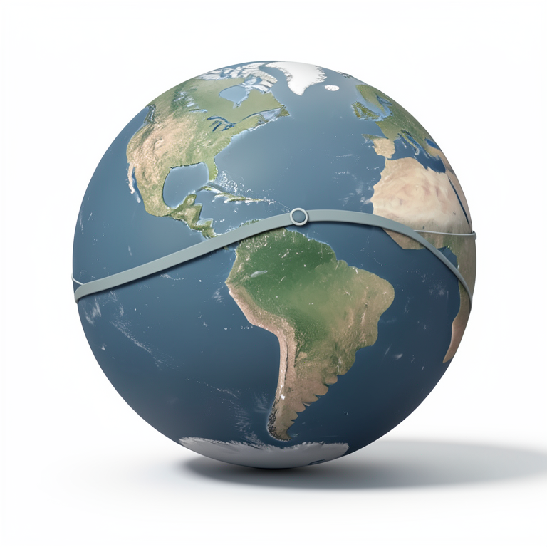
Great Circle vs Rhumb Line
AI-generated conceptual illustration (a globe representing Earth). It explains the idea and does not show study data.
View source evidence ↗Figures & tables
From the original paper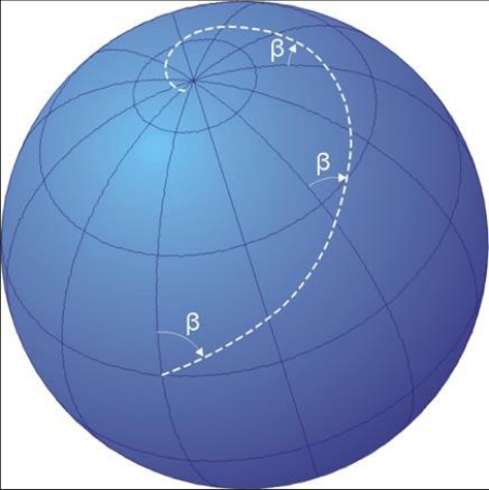 Figure 1
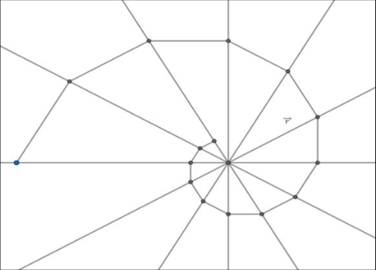 Figure 2
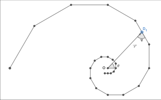 Figure 3
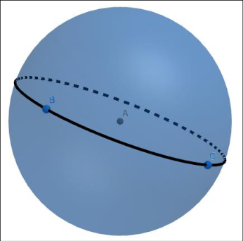 Figure 4
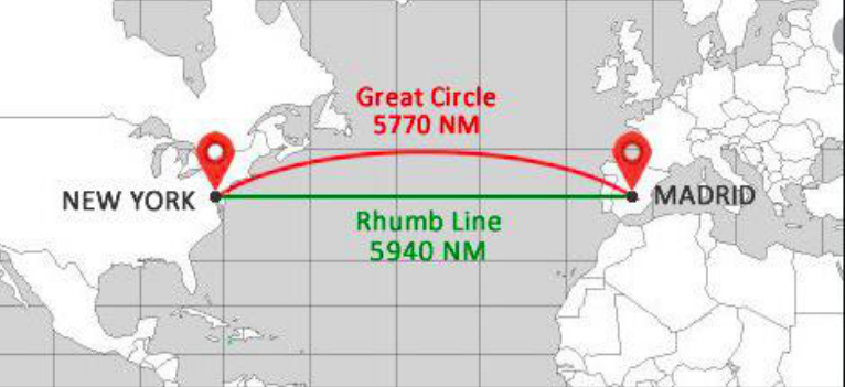 Figure 5
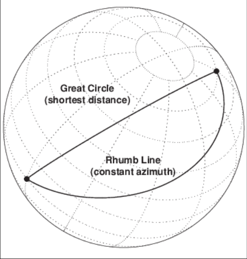 Figure 5
Introduction
With the evolution of ideas about the Earth's shape, the idea of distances between two places has also evolved. Navigators in the past would follow routes that circumference continents. This only led to increased time of travel. Over the years, the organisation and division of the Earth into different zones has greatly developed. The development of the concept of latitudes and longitudes specifically helped in the mathematical development of the ideas of distances. It paved the way for development of standard formulae that helps us calculate distances between points. I came across two such methods of distance calculation: great circle theory and rhumb line. When reading up about these theories, I found that they both are considered straight lines in different depictions of the Earth. It interested me to see the distinction between the two paths and question which path is preferred and why. I found it engaging to see the mathematical concepts that were utilised to gain the standard travel times and distances today. As someone who has travelled a lot, this exploration would finally answer the question a passenger has every time they sit on a plane: "Why is the flight path an arc and not a line?" The great circle theory answers this very question. It states that the great circle route is the shortest distance of travel between any two points on Earth. Previously, the landmasses would have hindered following great circle routes. But now with the development of air travel, time of flight can be reduced through following this mathematical concept. The purpose of this exploration is to test the well-known methods of rhumb line routes and great circle theory and gain insight into the mathematical background that went into the development of these methods.
Terms to Note
Latitude: Circular lines running horizontally around the globe are called latitudes. The equator is the latitude that lies at the centre of the Earth. All latitudes are parallel to each other and decrease in radius as you move towards the poles. Two latitudes never intersect.
Longitude: Longitudes are lines that run vertically from north to south. They are all equal in length and meet at both the north and south pole. The Prime Meridian, passing through Greenwich London, is considered as the central meridian from which all other longitudes are measured.
Azimuth: It is the angular measurement in a spherical coordinate system. If the vector between the point of origin and point of interest is projected perpendicularly onto the reference plane, http://www.mathsjournal.com the angle between the projected vector and a reference vector on the plane is called the azimuth.
International Air Transport Association (IATA)-It is an international trade organisation that coordinates international affairs and establishes standards for airline companies. All airport codes and coordinates considered in this paper are according to the IATA.
Rhumb Line
A rhumb line is a line that cuts all meridians at the same angle, other than a right angle. Since the earth is a sphere, the rhumb line is a spherical spiral. Mathematically, it can be called a logarithmic spiral.
A Mercator Projection
Mercator Projection is a type of projection that was introduced by Gerardus Mercator in 1569. It is also known as the cylindrical orthomorphic projection. It is constantly used in navigation processes. Mercator's projection became an important tool in the 16 th and 17 th century because at that time, the Western European countries like France, Great Britain and Portugal needed it for efficient navigation to their imperialistic colonies. On a Mercator projection, the loxodromes (or rhumb lines) are straight lines.
B Logarithmic Spiral
A logarithmic spiral is a self-similar spiral that was studied first by Rene Descartes in 1638. It is also called the growth spiral or equiangular spiral. This spiral can also be related to the Fibonacci numbers and called the golden spiral. And the angle between the tangent and the radial line at point (𝑟, 𝜃):
⁄ Angle between tangent and radial line is always perpendicular for a circle. Hence, as 𝑏 → 0, 𝜓 → 𝜋 2 ⁄ and the spiral approaches a circle.
Parametrically, coordinates of a point of a logarithmic spiral it can be expressed as 𝑥 = 𝑟 cos 𝜃 = 𝑎𝑒 𝑏𝜃 cos 𝜃 -(4) 𝑦 = 𝑟 sin 𝜃 = 𝑎𝑒 𝑏𝜃 sin 𝜃 -( 5) Hence, the spiral can be expresses as (𝑎𝑒 𝑏𝜃 cos 𝜃 , 𝑎𝑒 𝑏𝜃 sin 𝜃)
If any point D1 on the spiral is considered, the length of the spiral from D1 to the origin is finite. If the point is at a distance of 𝑟 ⃗ from origin, the distance of P to the pole along the spiral is simply the arc length.
Great Circles
Any circle drawn on the surface of the Earth that has the centre of the Earth as its centre and the diameter of the Earth as its diameter is called a great circle. Any great circle would divide the Earth into two halves. All longitudes are great circles; however, amongst the latitudes, only the Equator is a great circle. The great circle is an important concept because it is considered to give the shortest distance between any two points on Earth. Hence, it becomes an important value for airplane navigations.
A great circle can be drawn between any two points on the surface of the Earth All formulae are being applied to a perfectly spherical earth. It is not considered as an irregularly shaped ellipsoid and the flattening of the Earth at the poles is neglected. Haversine formula can be used to calculate the great circle distance between any two points provided that their latitude and longitude are given.
The Other Trigonometric Functions
The world of mathematics contains trigonometric formulae beyond the three commonly known sine, cosine and tangent. They are no longer required and their values can be represented by the common functions only, but at one point they were important enough to name.
𝑣𝑒𝑟𝑠𝑖𝑛 𝜃 = 1 -cos 𝜃 𝑣𝑒𝑟𝑐𝑜𝑠𝑖𝑛 𝜃 = 1 + cos 𝜃 𝑐𝑜𝑣𝑒𝑟𝑠𝑖𝑛 𝜃 = 1 -sin 𝜃 𝑐𝑜𝑣𝑒𝑟𝑐𝑜𝑠𝑖𝑛 𝜃 = 1 + sin 𝜃 ℎ𝑎𝑣𝑒𝑟𝑐𝑜𝑠𝑖𝑛𝑒 𝜃 = cos 2 𝜃 2 For the purpose of this derivation, we need the value of haversine function only:
1 -cos 𝜃 = 1 -sin 2 𝜃 2 If this value is put in the haversine formula, we get:
ℎ𝑎𝑣𝑒𝑟𝑠𝑖𝑛𝑒 𝜃 = sin 2 𝜃 2 Now to apply this for distance calculation on the Earth's surface consider two points A and B. Let d be the great circle distance between the two points, r be the radius of the Earth and 𝜃 be the angle between the two points at the centre of the Earth. Let A be located at latitude 1 and longitude 1 and let B be located at latitude 2 and longitude 2 Now, ∆𝜑 = 𝜑 1 -𝜑 2 ∆𝜆 = 𝜆 1 -𝜆 2 The haversine formula states that ℎ𝑎𝑣𝑒𝑟𝑠𝑖𝑛 𝜃 = ℎ𝑎𝑣𝑒𝑟𝑠𝑖𝑛 ∆𝜑 + cos 𝜑 1 cos 𝜑 2 ℎ𝑎𝑣𝑒𝑟𝑠𝑖𝑛 ∆𝜆 ⇒ ℎ𝑎𝑣𝑒𝑟𝑠𝑖𝑛 𝜃 = ℎ𝑎𝑣𝑒𝑟𝑠𝑖𝑛 (𝜑 1 -𝜑 2 ) + cos 𝜑 1 cos 𝜑 2 ℎ𝑎𝑣𝑒𝑟𝑠𝑖𝑛 (𝜆 1 -𝜆 2 )
We know that 𝑎𝑟𝑐 = 𝑟𝑎𝑑𝑖𝑢𝑠 × 𝑎𝑛𝑔𝑙𝑒 ⇒ 𝑎𝑛𝑔𝑙𝑒 = 𝑎𝑟𝑐 𝑟𝑎𝑑𝑖𝑢𝑠 ⁄ ⇒ 𝜃 = 𝑑 𝑟 ⁄ ⇒ 𝑑 = 𝑟𝜃 ⇒ 𝑑 = 2𝑟 sin -1 √ sin 2 (𝜑 1 -𝜑 2 ) 2 + cos 𝜑 1 cos 𝜑 2 sin 2 (𝜆 1 -𝜆 2 ) 2
B Difference Between Rhumb Line and Great Circle
There is a clear distinction between a rhumb line and a great circle. While the rhumb line would be a straight line on a 2-D projection of the Earth, the great circle is a straight line on the spherical Earth itself.
It is common knowledge that the straight line joining any two points is considered to be the shortest distance between them. However, this is only the case for a two-dimension plane. When the Earth is in question, it must be considered as the threedimensional model it is. In reality it is an irregularly shaped ellipsoid. Mathematical calculations become really irregular if every
Figures and tables from the paper
References
0 in the original paperCited by 3
From OpenAlex, OpenCitations and reference lists read by Scinovex
- Performance Evaluation of DGNSS Receiver for Dynamic Military Applications ↗
Moiz Chasmai, Gagandeep Purohit, Arun Kumar Barde, Sandeep Sandeep, Prashant Kumar, Abhijit Kamble · Defence Science Journal · 2024
In military applications, a highly accurate and precise navigation system is necessary for some ground-based combat system applications to navigate the vehicle and mark the location of the fuses and pickets laid by the mobile equipment. Few companies across the globe have developed expertise in manufacturing Global Navigation Satellite System (GNSS) receivers with Real Time Kinematics (RTK) capability along with…
❝ 1PDF - Characterization of gravity wave events detected in the low ionosphere at the Brazilian Antarctic Station ↗
Luís Tiago Medeiros Raunheitte, E. Correia, Jean‐Pierre Raulin, José Valentin Bageston · Journal of Atmospheric and Solar-Terrestrial Physics · 2024
❝ 1PDF - Smart mobility innovations and solar energy toward sustainable transportation ↗
Christiaan Coenrad Oosthuizen, Kyle Brand, David Richards, Andrew J. Cruden · AIP conference proceedings · 2026
❝ 0