
Research article · 2020 · Full text
International Journal of Research in AgronomyScientific substantiation of overcoming of existing ecological problems caused by separate impacts and recreational loads on landscape complexes on the south-western slopes of Azerbaijan (On the example of Sheki-Zakatala zone)
Volume 3(2) · Pages 47–50 · DOI: 10.33545/2618060x.2020.v3.i2a.38 ↗
Research areasMarine and environmental studiesEnvironmental and Biological Research in Conflict Zones
Abstract
Author-writtenIn the article, the landscape complexes of the Southern slope of the Caucasus react differently to different impacts and recreational loads on the example of Sheki-Zakatala zone, which is the object of study in terms of ecotourism development. In this regard, safe loads for one natural complex have been found to be critical for others. Recreational use of forests has been found to be of great importance for increasing the resource potential of society. Field research in light forests with recreational grass cover, for example, in Bunut forests of Sheki-Zakatala zone, oak-maple and oak-maple-hornbeam formations are not resistant to recreational vegetation. and the upper part of the soil is hard. As a result of trampling the seedlings, they perish. From this point of view, as a result of the transfer of forests around springs to private individuals, the forest is degraded, seedlings are trampled, the reaction force reaches a high level, anthropogenic pressure increases, and grass and moss cover is destroyed. Therefore, there are no young seedlings in the forests of Bunut. Forest grazing is more dangerous in this area. Thus, the existing seedlings are eaten by animals, trampled, and the soil is hardened. The current situation mainly affects a large area in the area around the basins of the Vendam, Damiraparan, Hamzali, Bum and Karachay rivers. Especially during the rainy season, animals damage the soil surface and vegetation more, causing the destruction of grass and moss layers, which is unacceptable.
Summary
Source-checkedPlain-language reading of the full paper, prepared with AI and checked against the text. Each point links to the authors' own words.
Why it matters
- Tourism is a strategically important sector for Azerbaijan's economy, particularly as part of its non-oil sector. View evidence ↗
- Recreational activities can lead to soil hardening, which disrupts soil structure and reduces air permeability and porosity. View evidence ↗
The question
- The research aims to assess the area for ecotourism to ensure proper organization, efficient land use, and the protection of land cover. View evidence ↗
What they did
- The study focuses on the landscape complexes of the Sheki-Zakatala zone on the Southern slope of the Caucasus to evaluate reactions to recreational loads. View evidence ↗
- The research area includes the Gabala State Nature Reserve, covering 39,680 hectares across several river basins and the Alvan gorge. View evidence ↗
- Soil ecological conditions were assessed based on relief, altitude, pH, humus content, temperature, and precipitation. View evidence ↗
What they found
- Trampling reduces undergrowth by 5% to 51% and decreases tree productivity by 2 to 3 times. View evidence ↗
- In the Bunut forests of the Gabala region, oak-maple and oak-maple-hornbeam formations were found to be non-resistant to recreational activities. View evidence ↗
- The forests of Bunut currently lack young seedlings due to the combined effects of trampling and grazing. View evidence ↗
- Animal damage to soil and vegetation, specifically the destruction of grass and moss layers, is intensified during the rainy season. View evidence ↗
- In the 'less complicated' plains and foothills (300-500m altitude), the soil is characterized by a humus level of 2.62, pH of 7.40, temperature of 10.4, and precipitation of 600-800 mm. View evidence ↗
- The 'very complicated' fragmented high mountain plateau (1500-2000m altitude) has a humus level of 3.84, pH of 7.30, temperature of 4.8, and precipitation of 1200-1400 mm. View evidence ↗
What it means
- The authors conclude that landscape complexes react differently to recreational loads, meaning a load level that is safe for one complex may be critical for another. View evidence ↗
- The authors emphasize the need for area inspection, registration, and studies on landscape resilience to increase recreational tolerance. View evidence ↗
Visual summary
2 visualsIllustrations explain the paper; charts are replotted from the paper's own table values.
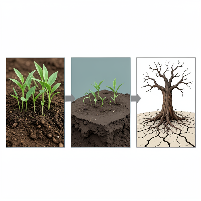
The Cycle of Recreational Degradation
AI-generated conceptual illustration (Forest soil and seedlings on the south-western slopes of Azerbaijan). It explains the idea and does not show study data.
View source evidence ↗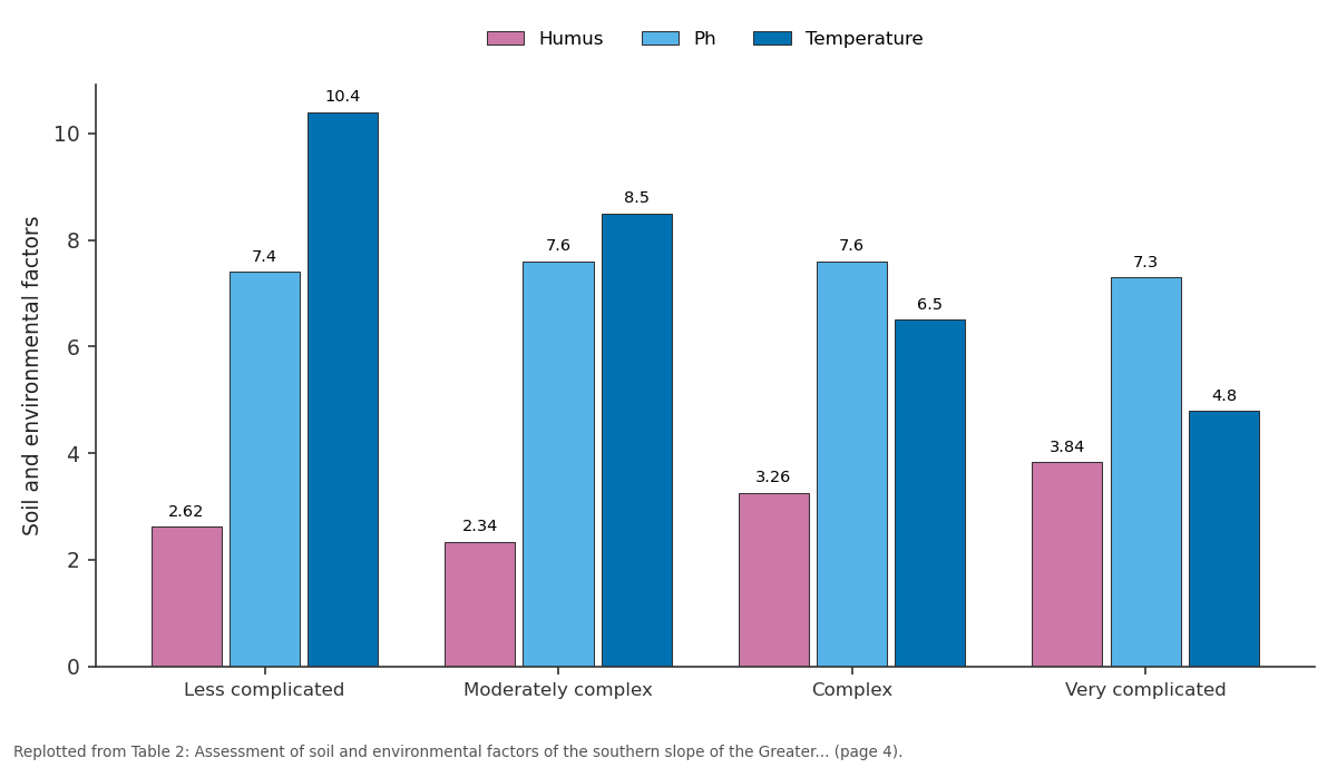
Humus and Ph and more: Less complicated vs Moderately complex vs Complex vs Very complicated
Replotted from Table 2 (page 4) of the original paper. Every bar is the paper's own table value.
View source evidence ↗Figures & tables
From the original paper Table 1
 Table 2
Introduction
Relevance of the study: Tourism is one of the fastest growing social and economic development directions of the XX century, which is of strategic importance. In this regard, tourism, which is part of the non-oil sector in Azerbaijan, has a special weight in strengthening the country's economy. It is also one of the areas of economic and political importance in the development of international economic relations. For this purpose, the implementation mechanism of the State Program on Tourism Development in the Republic of Azerbaijan for 2010-2014, approved by the Decree of the President of the Republic of Azerbaijan dated April 6, 2010, is of special importance. The main goal of this important state program is to form a modern tourism industry in Azerbaijan that meets high economic, social and environmental requirements and to ensure that it becomes one of the main pillars of the country's economy. It should be noted that the work done in this direction in the Republic over the past 10-15 years, the important state decisions on tourism and landscaping in the regions have given impetus to the development of tourism. Azerbaijan has also joined the world tourism system and is recognized [1,2,3,9] . Tourism is one of the factors that positively affect the growth of people's knowledge and skills, worldview and recreation. It should be noted that the understanding of self and the world through tourism has become possible due to the positive change in people's lives, the emergence of new modes of transport, the emergence of 21 new information technologies and, finally, the processes of globalization.
In tourism, consumer models are intertwined, and tourism is no longer a luxury for most people, but an essential element of the natural physiology of life. In the field of tourism, the natural environment, landscape complexes, social and economic development, historical and cultural ties, etc. Such components imitate people's tastes, give peace of mind and teach to love nature. In nature, it teaches the diversity of biodiversity in different places. From this point of view, Gabala region has its own place due to the richness of soil and vegetation. The total land fund of the region is 150,000 hectares and is very diverse due to its use [6,9] . In the south of the Sheki-Zakatala zone (Gabala, Şheki, Zakatala region), which is the object of research, from the low mountains bordering the Shirvan plain to the watershed peaks of the Greater Caucasus, the soil and vegetation cover is low. The rotation of areas and zones, which are distinguished by their diversity in accordance with the law of zoning, attracts attention [7] . Since 1993, the Gabala State Nature Reserve with a total area of 39,680 hectares has been established in the basins of the Vandam, Damiraparan, Hamzali, Bum and Garachay rivers, as well as in the Alvan gorge [8,11,12] . The reserve is home to a variety of trees and shrubs of the plain and mountain forest landscape, as well as endangered mountain goats, blackbirds, deer, bears, wild boars, lynxes, etc. rare animals are protected.
Aims and objectives of the Research:
The purpose of the assessment projects in terms of ecotourism is the proper organization of the area, efficient use of land cover, clarification of specialization, land reform, increasing productivity and protection of land cover. When calculating the economic assessment indicators, the basic indicators were used in the economic assessment of the cadastral price regions, which are mainly included in the economy. Environmental education of the population and ensuring the development of ecotourism in the area with great tourism potential is an important condition.
Object of Research:
In addition to protecting natural forest biocenoses around tourism facilities, it is also well promoted to tourists. As a result of field research, landscape changes in on the example of Sheki-Zakatala zone the Gabala region of the Southern Slope of the Greater Caucasus were noticeable, albeit insignificant. The vegetation of the area is difficult to adapt to climate change. Thus, as the drought lasts this year, the leaves of trees and shrubs are prematurely yellowed, protected and shed. Impact of recreational vegetation on the southern slope of the Greater Caucasus [3,10,14] . As the process of urbanization intensifies, most people want to spend their holidays in nature. For this reason, plants are trampled in nature. This is usually called "recreation". Recreation is derived from the Latin word "recreat.o", which means the restoration of physical and all kinds of activity. It is important to protect the area, as the increase in the number of people resting in recreational activities is inversely proportional. It is known that the recreational use of the forest is very serious. It is very profitable to use it for recreational purposes in some countries [9,13] . Although forests are of recreational and sanitary importance in our country, they are not used for recreational purposes. In the United States, 30% of state land is allocated for recreation. This figure can lead to the degradation of landscape recreation. The most important thing in the process of recreational use is the protection of nature. One of the main issues of the day is the inspection of the area, registration, study of its resilience to the effects of recreation, increasing the recreational tolerance of the landscape. The most important thing is that the boundaries of the phytocenosis can withstand the recreational load, otherwise the cost of the phytocenosis itself may fall. The tolerance of the boundaries of the phytocenosis allows to determine the recreational capacity, in other words, to determine how many people can rest in this area. At present, recreational weight is applied to different types of plants. Since most people come to the forest for recreation, many recreational effects take place in the forest phytocenosis. the most important work is to analyze the recreational tolerance of the forest [10,14] . Recreation affects the grass and tree strata, forest floor, seedlings, soil, wildlife, etc. from various components in the forest biocenosis. Under the influence of reclamation, the soil hardens, soil porosity, air permeability deteriorates and its structure is disrupted. As a result of soil hardening, anaerobic processes increase, the process of oxidation and reduction changes, the water regime of the soil deteriorates, and root growth becomes more difficult. Forest debris, moisture, heat, and air are very important in storing nutrients in the soil.In recreational forests, sedimentation is reduced or absent, which leads to soil freezing, reduced humus, and weakened grass cover [6,12] . As a result of trampling, the undergrowth is reduced from 5% to 51%, the viability of all tiers is reduced, and the productivity of trees is reduced by 2-3 times.
Grass Tier
Studies have shown that when the forest phytocenosis is used for recreational purposes, the grass layer is primarily damaged. One of the main components of the forest phytocenosis is grass, grass plays a role in regulating the microclimate and microbiological processes in the forest. The grass tier is stable in carrying the recreational load. According to the species composition of grasses, it is possible to determine the state of anthropogenic impact. Research shows that an increase in the recreational load affects the reduction in the number of plant species and the proportion of individuals [14] . In the forest, ornamental plants are not only trampled, but often collected as a bouquet of flowers, most often in the vicinity of cities. According to the duration of recreation, grasses are divided into 3 groups:
1. low-strength, 2. quite durable, 3. perennial plants.
From plants belonging to the less durable group, umbrellas, raspberries, etc., meadow grains from medium-resistant plants, chillies, etc., road grasses to perennial grasses, sagebrush, plantain, etc. [11,12] .
Mesophilic forest belt of high and medium mountains A belt of xerophilous forests in the middle and low mountains The grass cover is not damaged
The grass cover is damaged Degraded forests and forest-meadow species are weakened The grass cover is degraded, the number is sharply reduced, the stratification remains In the upper part of the forest, the grass cover was sharply damaged.
The grasses characteristic of the forest phytocenosis are degraded.
Degraded forests and forest-meadow species are weakened. Grass cover is degraded, the number is sharply reduced, and stratification remains.
In the upper part of the forest, the grass cover was sharply damaged. The grasses characteristic of the forest phytocenosis are degraded.
In light forests with recreational grass cover, for example, in Bunut forests of Gabala region, oak-maple and oak-maplehornbeam formations are not resistant to recreation. The natural regeneration of the forest has been disrupted as a result of recreation of the seedlings under the forest, and the upper part of the soil is hardened. Here, as a result of the trampling of seedlings, they perish. From this point of view, as a result of the transfer of forests around springs to private individuals, the forest is degraded, seedlings are trampled, the reaction force reaches a high level, anthropogenic pressure increases, and grass and moss cover is destroyed.
Therefore, there are no young seedlings in the forests of Bunut. Forest grazing is more dangerous in this area, the existing seedlings are eaten by animals, trampled, and the soil is hardened.
Especially during the rainy season, animals damage the soil surface and vegetation more, causing the destruction of grass and moss layers. This results in soil erosion on sloping slopes. Forests are damaged by tourists (trees, bushes and grass are damaged) and cars. Mechanical effects cause soil compaction and destruction of perennial grasses. As a result of soil hardening, one part of the soil remains dry and the other part becomes moist, which worsens the nutrition of trees. Weakening of nutrition prevents the growth and development of trees. This is especially true in coniferous forests [6,7] . Soil hardening disrupts its structure, reduces porosity, and worsens the living conditions of soil microorganisms. The landscape complexes of the southern slope of the Greater Caucasus react differently to different influences and recreational loads. Therefore, safe downloads for one natural complex may be critical for others. Recreational use of forests is of great importance for increasing the resource potential of society.
Rest in nature eliminates work stress and has a positive effect on people's ability to work. However, recreation around the city significantly harms the environment. Thus, recreational loads increase in forest areas, resulting in deteriorating forest quality or complete degradation. At the same time, the sanitaryhygienic, water protection and soil protection functions of forests are weakened, and their aesthetics is reduced. Climatic factor is the main factor that causes plants to spread on the earth in zones and zones. In mountainous areas, relief can change the climate by influencing it, in other words, it becomes a key factor in the spread of plants [2,9] . Relief is of great importance in the formation and development of soil and vegetation.
Relief is a major factor in the distribution of solar radiation and precipitation, depending on the visibility and slope of the slopes, and affects soil water, heat, nutrients, oxidation-reduction and salt regimes, plant productivity and species composition.
Studies have shown that the surface of different slopes and slopes do not receive the same amount of solar radiation. This is reflected in the temperature and water regime. Depending on the altitude of the mountains, the vertical zone of climate, vegetation and soils is formed due to lower temperatures and changes in humidity.
On the southern slope of the Greater Caucasus, as air masses approach the mountains, they gradually rise, cool, and cause precipitation [8,14] .
As can be seen from the table, the degree of complexity of the area, relief, altitude, humus, Ph, temperature, precipitation were calculated on the basis of the collected data.
In the plains and foothills of the region, 300-500 altitude, humus 2.34, Ph 7.40, temperature 10.4, precipitation 600-800 mm. In the low mountainous area, the height is 500-600 mm, humus 2.62, Ph 7.60, temperature 8.5, precipitation 800-1000 mm. The height is 600-1500 mm, humus 3.26, Ph 7.60, temperature 6.5, precipitation 1000-1200 mm in the fragmented middle mountainous area.
In the fragmented high mountain plateau, the height is 1500-2000, humus 3.84, Ph 7.30, temperature 4.8, precipitation 1200-1400 mm. The main criteria in assessing the soil ecological condition of the area were the characteristics of the relief, altitude, soil environment (pH), humus, temperature, precipitation.
Figures and tables from the paper
| Mesophilic forest belt of high and medium mountains | A belt of xerophilous forests in the middle and low mountains |
|---|---|
| The grass cover is not damaged | The grass cover is damaged |
| Degraded forests and forest-meadow species are weakened | The grass cover is degraded, the number is sharply reduced, the stratification remains |
| In the upper part of the forest, the grass cover was sharply damaged. | The grasses characteristic of the forest phytocenosis are degraded. |
Table text extracted from the original PDF; superscript letters are shown inline. The original table image is below.
View original table image
| The degree of complexity of the area | Relief | Height | Humus | Ph | Temperature | Precipitation, in mm |
|---|---|---|---|---|---|---|
| Less complicated | Plains and foothills | 300-500 | 2.62 | 7.40 | 10.4 | 600-800 |
| Moderately complex | Low mountainous area | 500-600 | 2.34 | 7.60 | 8.5 | 800-1000 |
| Complex | Fragmented middle mountainous area | 500-1500 | 3.26 | 7.60 | 6.5 | 1000-1200 |
| Very complicated | Fragmented high mountain plateau area | 1500-2000 | 3.84 | 7.30 | 4.8 | 1200-1400 |
Table text extracted from the original PDF; superscript letters are shown inline. The original table image is below.
View original table image
References
15 in the original paper- Abdullayev AH. Economic and geographical problems of tourism development in Azerbaijan, Baku, 2006
- Azar VI. Economics and organization of tourism. М, Economics, 1993.
- Land atlas of the Republic of Azerbaijan. Baku. Printing of Baku Cartography Factory, 2007, 102.
- Bilalov BA, Gulaliyev CH. Fundamentals of Tourism" - Baku, 2015
- Babayev FA. Protection of flora. Baku, 2005, 214.
- Gurbanov FI, Problems of tourism development in Azerbaijan. Baku, 2007.
- Ismayilov CHN, Zeynalova KZ. Materials of the international conference "Cluster concept and its importance in regional development", "H. Aliyev and development of geography in Azerbaijan" Baku, 2013, 80-82.
- Alirzayev AG Economics and management of tourism Baku, 2010.
- Zeynallı YQ. Economic and geographical problems of activity and management of tourism system in Azerbaijan, Baku, 1999.
- Nabiyev NA. Economic, social and environmental environment. Baku, 2000.
- Mammadov GSH, Khalilov MY. Ecology and protection of the environment". Baku, 2005, 879.
- Mammadov QSh. Ecological assessment of Azerbaijani lands. Baku, 1998, 282
- Mammadov QSh, Khalilov MY. Ecology, environment and man Baku, 2006, 607
- Mammadov Q.Sh, Khalilov MY. Azerbaijan forests. Baku. Elm, 2002, 427.
- Hüseynova GA. Ecological assessment of forest lands of the Southern slope of the Greater Caucasus. Abstract of the dissertation for the degree of biol. elml. namiz. alim, Baku, 2007, 19.
Cited by 1
From OpenAlex, OpenCitations and reference lists read by Scinovex
- Scientific Substantiation of Overcoming of Existing Ecological Problems Caused By Separate Impacts and Recreational Loads on Landscape Complexes on the South-Western Slopes of Azerbaijan(on the Example of Sheki-Zakatala Zone) ↗
Z Aliyev, G.A. Huseynova · Journal of Travel Tourism and Recreation · 2020
In the article, the landscape complexes of the Southern slope of the Caucasus react differently to different impacts and recreational loads on the example of Sheki-Zakatala zone, which is the object of study in terms of ecotourism development.In this regard, safe loads for one natural complex have been found to be critical for others.Recreational use of forests has been found…
❝ 0PDF